
Natural Resources
Conservation Service
Ecological site R043CY801OR
Cold Dry Subalpine Grasslands
(FEVI)
Last updated: 2/12/2025
Accessed: 08/29/2026
-
Search


Major Land Resource Area or ecological site by name and/or ID.
PreviousSectionsNextGeneral information
Provisional. A provisional ecological site description has undergone quality control and quality assurance review. It contains a working state and transition model and enough information to identify the ecological site.
Click to explore map
Figure 1. Mapped extent
Areas shown in blue indicate the maximum mapped extent of this ecological site. Other ecological sites likely occur within the highlighted areas. It is also possible for this ecological site to occur outside of highlighted areas if detailed soil survey has not been completed or recently updated.
MLRA notes
Major Land Resource Area (MLRA): 043C–Blue and Seven Devils Mountains
This MLRA covers the Blue and Seven Devils Mountains of Oregon, Washington and Idaho. The area is characterized by thrust and block-faulted mountains and deep canyons composed of sedimentary, metasedimentary, and volcanic rocks. Elevations range from 1,300 to 9,800 feet (395 to 2,990 meters). The climate is characterized by cold, wet winters and cool, dry summers. Annual precipitation, mostly in the form of snow, averages 12 to 43 inches (305 to 1,090 millimeters) yet ranges as high as 82 inches (2,085 millimeters) at upper elevations. Soil temperature regimes are predominately Frigid to Cryic and soil moisture regimes are predominately Xeric to Udic. Mollisols and Andisols are the dominant soil orders. Ecologically, forests dominate but shrub and grass communities may occur on south aspects and lower elevations as well as in alpine meadow environments. Forest composition follows moisture, temperature and elevational gradients and typically ranges from ponderosa pine and Douglas-fir plant associations at lower elevations, grand fir at middle elevations and subalpine fir and Engelman spruce at upper elevations. Historical fire regimes associated with these forest types range from frequent surface fires in ponderosa pine - Douglas Fir forest types to mixed and stand replacing fire regimes in grand fir and subalpine fir types. A large percentage of the MLRA is federally owned and managed by the U.S. Forest Service for multiple uses.
Classification relationships
Plant Assoc. of Blue and Ochoco Mountains (R6 E TP-036-92)
Green fescue - GS11
Hood's sedge - GS64
Western needlegrass - GS10
Plant Assoc. of Wallowa-Snake Province (R6 E 255-86)
Green fescue-Hood's sedge - GS1111
Green fescue-spurred lupine - GS1112
U.S. National Vegetation Classification System (USNVCS)
Group: G271. Rocky Mountain-North Pacific Subalpine-Montane Mesic Grassland & Meadow
Alliance: A1257: Festuca viridula - Carex hoodii - Lupinus spp. Subalpine Mesic Meadow AllianceEcological site concept
This is a high elevation grassland site occurring in the Blue and Wallowa mountains of Oregon. The vegetation composition is characterized by dominance of greenleaf fescue, yet other graminoids such as Ross' sedge, Hood's sedge, and Western needlegrass are also common. Common forbs include lupine, penstemon and sandwort. This site occurs on basins and ridgetops in the subalpine zone often in complex with subalpine fir and whitebark pine woodlands, where exposed positions, or coarse textured, drought prone and/or shallower soils preclude forest vegetation. Fire was rare in this site type yet grazing by both native and introduced ungulates has had considerable influence over the ecological dynamics of the site. The soil temperature regime is Cryic and the soil moisture regime is Xeric.
This is a provisional ecological site and is subject to extensive review and revision before final approval. All data herein should be considered provisional and contingent upon field validation prior to use in conservation planning.Associated sites
F043CY601OR Cold Wet Conifer Mountains and Plateaus (ABLA/VASC-VAME)
Adjacent forested areas with deeper soils, often on nearby backslope positions
Similar sites
F043CY601OR Cold Wet Conifer Mountains and Plateaus (ABLA/VASC-VAME)
Deeper soils, often on moisture holding aspects and protected positions
Table 1. Dominant plant species
Tree Not specified
Shrub Not specified
Herbaceous (1) Festuca viridula
Physiographic features
This site occurs in high elevation basins and mountains near timberline. Often occupying upper mountain slopes and plateaus, this site may also occur on lateral moraines. It typically occurs on variable gentle to steep slopes with linear or convex profiles. This site occurs on all aspects but may tend toward southerly aspects. Slopes typically range from 15 to 60% but may range from 0 to 90%. Elevation varies from 5800 to 8400 ft (1750 - 2550 m) with 6400 to 7500 ft (1950 - 2300 m) being the most common. This site does not experience ponding or flooding and no water table is present within the upper two meters of soil.
Table 2. Representative physiographic features
Landforms (1) Mountains > Mountain slope
(2) Mountains > Lateral moraine
(3) Mountains > Plateau
Flooding frequency None Ponding frequency None Elevation 6400 – 7500 ft Slope 2 – 60 % Ponding depth 0 in Water table depth 100 in Aspect W, NW, N, NE, E, SE, S, SW Table 3. Representative physiographic features (actual ranges)
Flooding frequency Not specified Ponding frequency Not specified Elevation 5800 – 8400 ft Slope 0 % Ponding depth 0 in Water table depth 0 in Climatic features
The annual precipitation typically ranges from 40 to 60 inches (1,000 - 1,500 mm). The precipitation occurs as snow during the months of November through March followed by spring rainfall. Localized, occasionally severe, convection storms occur during the summer. The mean annual air temperature is approximately 38 to 42 degrees F (3 to 5.5 degrees C) . Soil temperature regimes are cryic. The frost-free period ranges from 15 to 60 days. The period of optimum plant growth is from late May through mid August. Climate graphs are populated from the closest available weather stations and are included to represent general trends rather than representative values.
Table 4 Representative climatic features
Frost-free period (characteristic range) 20-60 days Freeze-free period (characteristic range) Precipitation total (characteristic range) 40-60 in Frost-free period (average) 30 days Freeze-free period (average) Precipitation total (average) 50 in Characteristic rangeActual rangeBarLineFigure 2. Monthly precipitation range
Characteristic rangeActual rangeBarLineFigure 3. Monthly minimum temperature range
Characteristic rangeActual rangeBarLineFigure 4. Monthly maximum temperature range
BarLineFigure 5. Monthly average minimum and maximum temperature
Figure 6. Annual precipitation pattern
Figure 7 Annual average temperature pattern
Climate stations used
-
(1) SENECA [USC00357675], Seneca, OR
">Influencing water features
High elevation snowfields provide meltwater which often supplements site soil moisture into the summer season. On degraded and denuded slopes this meltwater may create gully and sheet erosion. Variations in late season snow persistence will influence site productivity and potential for erosion.
Soil features
The soils of this site are formed in colluvium derived from basalt or granite, or glacial till, with a thin mantle of volcanic ash (or ash mixed with loess) in the surface or ash mixed throughout the profile. They are typically moderately deep but may range to shallow. Surface textures often contain substantial coarse fragment content and range from extremely cobbly ashy silt loam, gravelly ashy loam, very stony ashy very fine sandy loam and extremely stony ashy coarse sandy loam. The particle size class is typically loamy-skeletal. Erosion potential is high. Frosts action is moderate to high. Taxonomic classifications include Haploxerandic Humicryepts, Lithic Humicryepts and Vitrandic Humicryepts.
Table 5. Representative soil features
Parent material (1) Colluvium – basalt
(2) Colluvium – granite
(3) Till
Surface texture (1) Extremely stony coarse sandy loam
(2) Extremely cobbly silt loam
(3) Gravelly loam
(4) Very stony very fine sandy loam
Family particle size (1) Loamy-skeletal
Drainage class Well drained Permeability class Moderately slow to moderate Depth to restrictive layer 20 – 40 in Soil depth 20 – 40 in Surface fragment cover <=3" 0 – 45 % Surface fragment cover >3" 0 – 45 % Available water capacity
(0-40in)0.5 – 3.9 in Soil reaction (1:1 water)
(0-40in)5 – 6.2 Subsurface fragment volume <=3"
(4-40in)10 – 40 % Subsurface fragment volume >3"
(4-40in)15 – 65 % Table 6. Representative soil features (actual values)
Drainage class Not specified Permeability class Not specified Depth to restrictive layer 10 – 40 in Soil depth 10 – 40 in Surface fragment cover <=3" 0 % Surface fragment cover >3" 0 % Available water capacity
(0-40in)0 in Soil reaction (1:1 water)
(0-40in)0 Subsurface fragment volume <=3"
(4-40in)0 % Subsurface fragment volume >3"
(4-40in)0 % Ecological dynamics
The reference plant community of this site is dominated by greenleaf fescue (Festuca viridula), with western needlegrass (Achnatherum occidentale), Hood's sedge (Carex hoodii), and Ross' sedge (Carex rosii) and Parry's rush (Juncus parryi) also common. A diverse array of perennial forbs may occur in minor amounts with common members including lupines (Lupinus spp.), common yarrow (Achillea millefolium), penstemons (Penstemon spp.), buckwheats (Erioganum spp.), and prickly sandwort (Arenaria aculeata). Community compositions with higher proportion of Idaho fescue (Festuca idahoensis) may be found on warmer exposures and areas with shallower soil. Variability in plant composition and productivity is dependent on aspect, soil depth and duration of ephemeral subsurface flows. Green fescue strongly dominates the community in the reference state often forming a nearly forb-free continuous sod mat with interspaces consisting of litter. There is a virtual absence of bare ground and erosion pavement. Sedges increase on deeper soils receiving additional late season subsurface flows. Needlegrasses increase slightly on shallower soils and on granitic parent materials. Production increases with soil depth.
Fire was likely historically infrequent in this site due to cool and moist conditions for much of the year. Disturbance regimes have historically been influenced by climate cycles modifying snowpack and the impacts of ungulate herbivory and rodent burrowing. Chronic overutilization and improper management of livestock may result in a decline in green fescue cover and a subsequent increase in forbs and other graminoides. Forbs that often experience increased cover include poke knotweed (Polygonaum phytolaccifolium), fleabane (Erigeron spp.), yarrow, lupine, and western coneflower (Rudbeckia occidentalis). Graminoids that may increase include hood's sedge, parry's sedge, and needlegrasses (Achnatherum spp.). With continued deterioration the sod is broken, bar soil is rapidly removed by accelerated water erosion and potential site productivity is lost. Deteriorated green fescue communities are characterized by a distinctive hummocky appearance with deflation depressions containing an erosion pavement (Johnson 2004). Letterman's needlegrass (Achnatherum occidentale), Ross' sedge, pussytoes (Antenaria spp.), prickly sandwort, buckwheat and penstemons often increase on erosion pavement between hummocks and pedestals. Rushes, poke knotweed, coneflower and other forbs increase on increase on remnant pedestals. Bare soil and soil mounds may also be created by rodent disturbance, especially pocket gophers.
Heavy grazing by sheep herds following European settlement has had significant impacts on much of the range of this site, leading to the existence of alternative states. In many areas, herd size peaked near the turn of the 20th century then dropped near the middle of the 20th century. Currently in many areas this historical land use has been significantly reduced or eliminated however impacts remain on the landscape. Elk herds may impact these communities as well and population fluctuations have been linked to altered site condition. Long-term documented evidence shows that on badly eroded sites with significant topsoil loss, green fescue will be present only as sparsely scattered plants even after 50 years of protection from heavy grazing. If the site is not eroded and green fescue remnants are present, the site may recover much of its ecological structure and function in as little as 20 years (Johnson 2003). Encroachment of subalpine fir (Abies lasiocarpa) and whitebark pine (Pinus albicaulis) into these grasslands may also occur on this site where soil depth and physiography allow for conifer establishment.State and transition model
More interactive model formats are also available. View Interactive Models
Click on state and transition labels to scroll to the respective textEcosystem states
T1A - Sustained overutilization by ungulates T2A - Further sustained overutilization and improperly managed grazing R3A - Sustained rest from grazing or dramatic reductions in ungulate stocking rate, duration or grazing intensity, potentially coupled with reseeding with native species and erosion control structures State 1 submodel, plant communities
1.1A - Sustained ungulate grazing and/or rodent disturbance. 1.2A - Extended rest from ungulate grazing or rodent disruptions or significant alterations in grazing management State 1
Reference
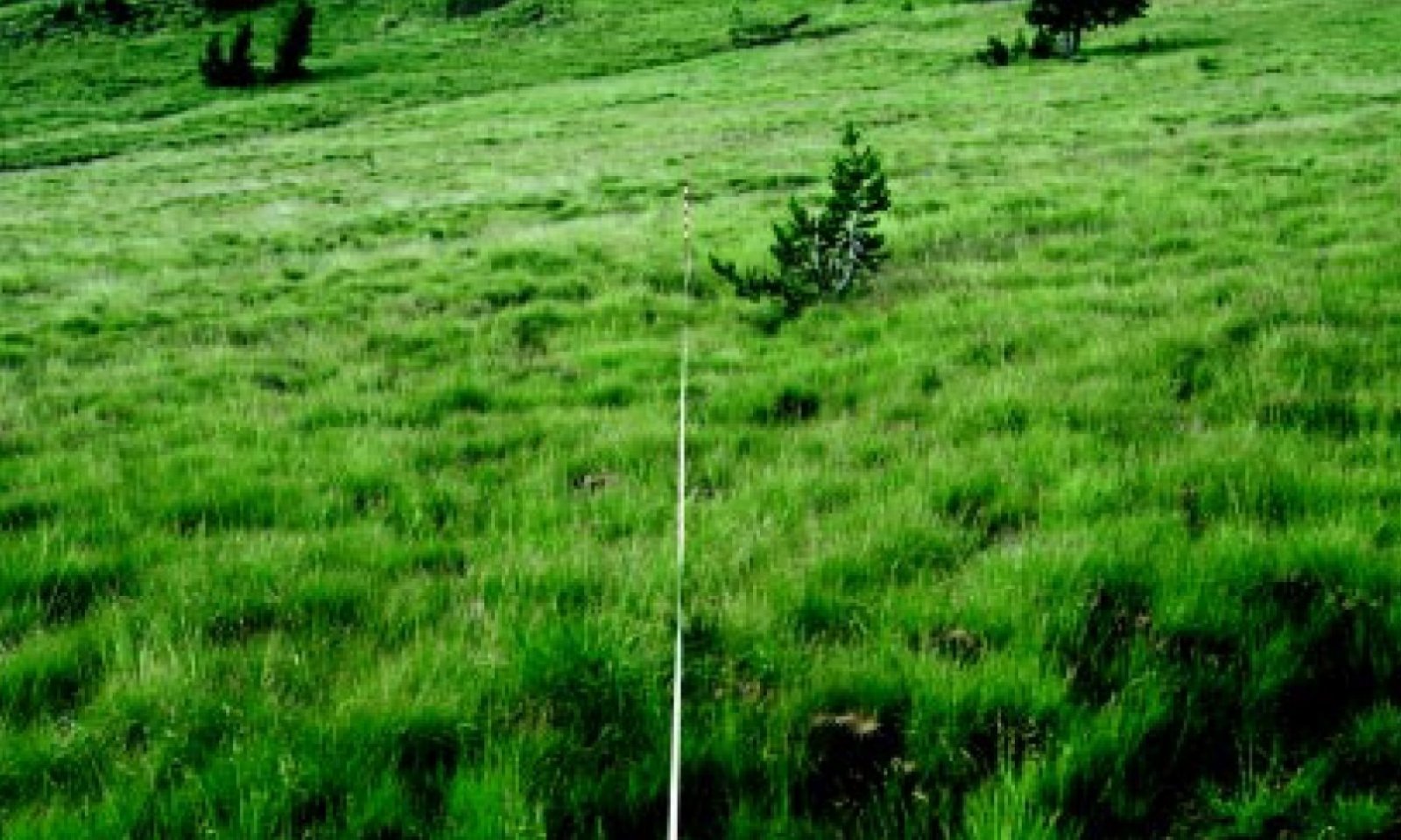
Figure 8. Reference greenleaf fescue dominated rangeland. from Johnson 2003.
Green fescue strongly dominates the community in the reference state often forming a nearly forb-free continuous sod mat with interspaces consisting of litter. Other graminoides also include western needlegrass (Achnatherum occidentale), Hood's sedge (Carex hoodii), and Ross' sedge (Carex rosii) and Parry's rush (Juncus parryi). A diverse array of perennial forbs may occur in minor amounts with common members including lupines (Lupinus spp.), common yarrow (Achillea millefolium), penstemons (Penstemon spp.), buckwheats (Erioganum spp.), and prickly sandwort (Arenaria aculeata). Variability in plant composition and productivity is dependent on aspect, soil depth and duration of ephemeral subsurface flows. Bare ground, plant productivity and composition is influenced by climate cycles, ungulate use and rodent burrowing.
Dominant plant species
-
greenleaf fescue (Festuca viridula), grass
-
Parry's rush (Juncus parryi), grass
-
Hood's sedge (Carex hoodii), grass
-
Ross' sedge (Carex rossii), grass
Community 1.1
Historic Reference Plant Community
Figure 9. Greenleaf fescue dominated plant community following 36 years of reduced ungulate use, from Johnson 2003.
The potential native plant community is strongly dominated by green fescue. Western needlegrass and lupines are common. Sedges, rushes and a variety of other forbs are present. The potential vegetative composition is approximately 90 percent grass and 10 percent forbs.
Figure 10. Annual production by plant type (representative values) or group (midpoint values)
Table 7. Annual production by plant type
Plant type Low
(lb/acre)Representative value
(lb/acre)High
(lb/acre)Grass/Grasslike 621 828 1035 Forb 36 97 162 Tree 18 27 36 Total 675 952 1233 Community 1.2
Disturbed community
Figure 11. Greenleaf fescue community following heavy sheep grazing, from Johnson 2003
Continued ungulate herbivory leads to a reduction in greenleaf fescue and a subsequent increase in needlegrasses and forbs and other graminoids such as poke knotweed (Polygonaum phytolaccifolium), fleabane (Erigeron spp.), yarrow, lupine, and western coneflower (Rudbeckia occidentalis), hood's sedge and parry's sedge. Communities dominated by western needlegrass, or codominated by Hood's sedge are included in this type. Areas of rodent burrowing disturbance, especially by pocket gophers, may also create patches of disturbance with increased forb composition. Bare ground may increase and some erosion may occur but it is within the historical range of variability for the site, however, continued use threatens to shift the community into alternative state 3, eroded state. This community may characterize the entire site or exist in localized occurrences depending on ungulate and rodent populations and duration of use.
Pathway 1.1A
Community 1.1 to 1.2
Historic Reference Plant Community
Disturbed communitySustained ungulate grazing and/or rodent disturbance.
Pathway 1.2A
Community 1.2 to 1.1
Disturbed community
Historic Reference Plant CommunityExtended rest from ungulate grazing or rodent disruptions or significant alterations in grazing management.
State 2
Current Potential
Figure 12. Tenderfoot Basin 50 years after significant reductions in sheep numbers and alterations in grazing practices, from Johnson 2003.
This follows long term recovery from chronic overutilization of the site by ungulates. The state mirrors the reference plant community yet some soil resources have been lost to erosion, mild hummocky topography may persist and plant community composition may be altered. Plant communities will likely host a greater composition of forbs and shallow-rooted graminoids with a reduction in greenleaf fescue. Long term documented evidence shows that on badly eroded sites (alternative state 3) with little topsoil left, green fescue will be present only as sparsely scattered plants even after 50 years of protection. If the site is not eroded and green fescue remnants are present the site may recover in as little as 20 years (Johnson 2003).
Dominant plant species
-
Letterman's needlegrass (Achnatherum lettermanii), grass
-
Hood's sedge (Carex hoodii), grass
-
Parry's rush (Juncus parryi), grass
-
greenleaf fescue (Festuca viridula), grass
-
lupine (Lupinus), other herbaceous
-
yarrow (Achillea), other herbaceous
-
beardtongue (Penstemon), other herbaceous
-
buckwheat (Eriogonum), other herbaceous
State 3
Eroded
Figure 13. Tenderfoot basin after several decades of sustained heavy grazing by sheep herds, from Johnson 2003.
Following sustained chronic overutilization, overstocking and improperly managed grazing, loss of continuous greenleaf fescue sod occurs and widespread erosion follows. Litter is decreased, and soil is displaced and lost from the site. These conditions set the stage for the generation of pedestals and hummocks where vegetation is able to hold on to some of the soil resource and eroded interspaces where erosion pavement forms. This eroded pavement is characterized by surface rock fragments and hosts a plant community mostly absent of greenleaf fescue and replaced by forbs and graminoids that can tolerate the shallower soil and coarse surface texture. These species may include Letterman's needlegrass, Ross' sedge, pussytoes, prickly sandwort, buckwheat and penstemons. Rushes, poke knotweed, coneflower and other forbs increase on remnant pedestals.
Dominant plant species
-
Letterman's needlegrass (Achnatherum lettermanii), grass
-
Ross' sedge (Carex rossii), grass
-
rush (Juncus), grass
-
buckwheat (Eriogonum), other herbaceous
-
pussytoes (Antennaria), other herbaceous
-
coneflower (Rudbeckia), other herbaceous
-
poke knotweed (Polygonum phytolaccifolium), other herbaceous
-
prickly sandwort (Arenaria aculeata), other herbaceous
-
beardtongue (Penstemon), other herbaceous
Transition T1A
State 1 to 2
Reference
Current PotentialSustained overutilization by ungulates leading to a reduction in vegetative cover, alterations of plant community composition, increases in bare ground and loss of some soil by erosion.
Transition T2A
State 2 to 3
Current Potential
ErodedFurther overutilization and improperly managed grazing, often by large sheep herds, will increase bare ground, decrease vegetative and litter cover and lead to widespread erosion and the creation of pedestals and deflation depressions.
Restoration pathway R3A
State 3 to 2
Eroded
Current PotentialSustained rest from grazing or dramatic reductions in ungulate stocking rate, duration or grazing intensity. Research has demonstrated that 30 - 50 years of improved management may return the site to a current potential state (Johnson 2003). If the plant communities have been further degraded and seed banks have been severely depleted, reseeding with native species and erosion control structures may be required but will be limited by topography, access and sites conditions.
Additional community tables
Table 8. Community 1.1 plant community composition
Group Common name Symbol Scientific name Annual production () Foliar cover (%) Grass/Grasslike1 Perennial Deep-rooted Dominant 540–720 greenleaf fescue FEVI Festuca viridula 540–720 – 2 Perennial Deep-rooted Sub-dominant 60–225 western needlegrass ACOC3 Achnatherum occidentale 45–135 – sedge CAREX Carex 18–90 – 5 SSSS 20–90 Letterman's needlegrass ACLE9 Achnatherum lettermanii 2–8 – timber oatgrass DAIN Danthonia intermedia 2–8 – squirreltail ELEL5 Elymus elymoides 2–8 – slender wheatgrass ELTR7 Elymus trachycaulus 2–8 – Drummond's rush JUDR Juncus drummondii 2–8 – Parry's rush JUPA Juncus parryi 2–8 – prairie Junegrass KOMA Koeleria macrantha 2–8 – oniongrass MEBU Melica bulbosa 2–8 – alpine timothy PHAL2 Phleum alpinum 2–8 – Cusick's bluegrass POCU3 Poa cusickii 2–8 – spike trisetum TRSP2 Trisetum spicatum 2–8 – Forb7 Perennial All Dominant 20–70 lupine LUPIN Lupinus 18–72 – 9 PPFF 20–90 common yarrow ACMI2 Achillea millefolium 1–5 – pussytoes ANTEN Antennaria 1–5 – prickly sandwort ARAC2 Arenaria aculeata 1–5 – alpine golden buckwheat ERFL4 Eriogonum flavum 1–5 – parsnipflower buckwheat ERHE2 Eriogonum heracleoides 1–5 – fleabane ERIGE2 Erigeron 1–5 – thickstem aster EUIN9 Eurybia integrifolia 1–5 – groundsmoke GAYOP Gayophytum 1–5 – Jessica sticktight HAMI Hackelia micrantha 1–5 – nodding microseris MINU Microseris nutans 1–5 – globe penstemon PEGL5 Penstemon globosus 1–5 – Rydberg's penstemon PERY Penstemon rydbergii 1–5 – silverleaf phacelia PHHA Phacelia hastata 1–5 – poke knotweed POPH Polygonum phytolaccifolium 1–5 – western coneflower RUOC2 Rudbeckia occidentalis 1–5 – ragwort SENEC Senecio 1–5 – Tree16 Perennial Evergreen Dominant 20–35 subalpine fir ABLA Abies lasiocarpa 9–18 – whitebark pine PIAL Pinus albicaulis 9–18 – Table 9. Community 1.2 plant community composition
Group Common name Symbol Scientific name Annual production () Foliar cover (%) Interpretations
Animal community
Livestock Grazing:
This site is suited to summer use by cattle and sheep under a planned grazing system. The key species is green fescue. Green fescue can be damaged if heavily grazed during periods of flowering and seed formation when root reserves are low. Care should be taken to avoid sod breakup, plant trampling damage and soil compaction when soils are wet.
Wildlife:
When the ecological condition is high this site provides food for mountain sheep, elk, deer and subalpine wildlife. Adjacent to sites with excellent cover, it is an important summer and fall use area for elk and deer.
Native Wildlife Associated With The Potential Climax Community:
Rocky Mountain bighorn sheep, elk, mule deer and a variety of subalpine wildlife use this site for food and limited cover.Hydrological functions
The soils of this site have good water holding capacities providing late season water for plant growth. The hydrologic cover condition is good when the ecological condition is high.
Other information
When in poor condition the site has a low potential for range seeding because of climatic limitatins, limited availabilty of green fescue seed, slope and stoniness.
Supporting information
References
-
1980. USNVC [United States National Vegetation Classification]. 2019. United States National Vegetation Classification Database, V2.03. Federal Geographic Data Committee, Vegetation Subcommittee, Washington DC.. USNVC: http://usnvc.org/.
-
Johnson Jr, C.G. and R.R. Clausnitzer. 1992. Plant Association of the Blue and Ochoco Mountains. Tech. Publ. R6-ERW-TP-036-92.. U.S. Department of Agriculture, Forest Service, Pacific Northwest Region, Wallow-Whitman National Forest, Portland, OR.
-
Johnson, C.G. and S.A. Simon. 1987. Plant Association of the Walla-Snake Province, Wallowa-Whitman National Forest. R6-ECOL-TP-225A-86.. U.S. Department of Agriculture, Forest Service, Pacific Northwest Region, Wallow-Whitman National Forest.
Other references
Johnson, Charles G., Jr. 2003. Green fescue rangelands: changes over time in the Wallowa Mountains. Gen. Tech. Rep. PNW-GTR-569. Portland, OR: U.S. Department of Agriculture, Forest Service, Pacific Northwest Research Station. 41 p.
Johnson, Charles G., Jr. 2004. Alpine and Subalpine Vegetation of the Wallowa, Seven Devils, and Blue Mountains. Technical paper R6-NR-ECOL. Portland, OR: U.S. Department of Agriculture, Forest Service, Pacific Northwest Research Station. 41 p.Contributors
Justin Gredvig
Andrew Neary - Further concept development for 2020 PES initiative
AV BahnApproval
Kirt Walstad, 2/12/2025
Rangeland health reference sheet
Interpreting Indicators of Rangeland Health is a qualitative assessment protocol used to determine ecosystem condition based on benchmark characteristics described in the Reference Sheet. A suite of 17 (or more) indicators are typically considered in an assessment. The ecological site(s) representative of an assessment location must be known prior to applying the protocol and must be verified based on soils and climate. Current plant community cannot be used to identify the ecological site.
Author(s)/participant(s) Jeff Repp Contact for lead author Oregon NRCS State Rangeland Management Specialist Date 07/30/2012 Approved by Approval date Composition (Indicators 10 and 12) based on Annual Production Indicators
-
Number and extent of rills:
None to some, severe sheet & rill erosion hazard -
Presence of water flow patterns:
None to some -
Number and height of erosional pedestals or terracettes:
None -
Bare ground from Ecological Site Description or other studies (rock, litter, lichen, moss, plant canopy are not bare ground):
5-10% -
Number of gullies and erosion associated with gullies:
None -
Extent of wind scoured, blowouts and/or depositional areas:
None, slight wind erosion hazard -
Amount of litter movement (describe size and distance expected to travel):
Fine - limited movement -
Soil surface (top few mm) resistance to erosion (stability values are averages - most sites will show a range of values):
Moderately resistant to erosion; aggregate stability = 3-5 -
Soil surface structure and SOM content (include type of structure and A-horizon color and thickness):
Moderately deep to shallow, well drained, with a stony loam surface; low OM (1-2%) -
Effect of community phase composition (relative proportion of different functional groups) and spatial distribution on infiltration and runoff:
Significant ground cover (80-90%) and moderate to steep slopes (2-60%) moderately limit rainfall impact and overland flow -
Presence and thickness of compaction layer (usually none; describe soil profile features which may be mistaken for compaction on this site):
None -
Functional/Structural Groups (list in order of descending dominance by above-ground annual-production or live foliar cover using symbols: >>, >, = to indicate much greater than, greater than, and equal to):
Dominant:
Green fescue > Western needlegrass > sedge > other grasses = forbs > treesSub-dominant:
Other:
Additional:
-
Amount of plant mortality and decadence (include which functional groups are expected to show mortality or decadence):
Normal decadence and mortality expected -
Average percent litter cover (%) and depth ( in):
-
Expected annual annual-production (this is TOTAL above-ground annual-production, not just forage annual-production):
Favorable: 1300, Normal: 900, Unfavorable: 600 lbs/acre/year at high RSI (HCPC) -
Potential invasive (including noxious) species (native and non-native). List species which BOTH characterize degraded states and have the potential to become a dominant or co-dominant species on the ecological site if their future establishment and growth is not actively controlled by management interventions. Species that become dominant for only one to several years (e.g., short-term response to drought or wildfire) are not invasive plants. Note that unlike other indicators, we are describing what is NOT expected in the reference state for the ecological site:
Needlegrasses, rushes, and perennial forb species will increase with detrioration of plant community. Excessive erosion occurs on the interspaces, deteriorating site potential. -
Perennial plant reproductive capability:
All species should be capable of reproducing annually
Print Options
Sections
Font
AAAAOther
PrintThe Ecosystem Dynamics Interpretive Tool is an information system framework developed by the USDA-ARS Jornada Experimental Range, USDA Natural Resources Conservation Service, and New Mexico State University.
Accessibility statement


