Natural Resources
Conservation Service
-
Search


Major Land Resource Area or ecological site by name and/or ID.
PreviousSectionsNextGeneral information
Draft. A draft ecological site description is either incomplete or has not undergone quality control and quality assurance review.
MLRA notes
Major Land Resource Area (MLRA): 035X–Colorado Plateau
This ecological site occurs in the northern portion of MLRA 35, Colorado Plateau Province. It is found principally in the in the Canyon Lands and High Plateaus of Utah sections within that MLRA. This area has been stucturally uplifted over time while rivers flowing across it were cutting down into it's bedrock. Areas of shale, sandstone, limestone, dolomite, and volcanic rock outcrop are found throughout the region.
Associated sites
R035XY308UT Upland Loam (Mountain Big Sagebrush)
Similar sites
R047XA302UT Upland Clay (low sagebrush)
Table 1. Dominant plant species
Tree Not specified
Shrub (1) Artemisia arbuscula
(2) Atriplex canescensHerbaceous (1) Pascopyrum smithii
(2) achnatherum hymenoidesPhysiographic features
This ecological site typically occurs on alluvial fans and flats, hills, ridges, valley flats and bottoms and on stream terraces. Slope and aspect have only a minor influence the vegetative floristics of this ecological site. Runoff is typically high to very high. Flooding and ponding do not occur or are very rare due to local landscape positions and the dry nature of the ecosystem. Slopes generally range from 2% to 6% but can range to 10%. Elevations range from 6200 to 7200 feet.
Table 2. Representative physiographic features
Landforms (1) Alluvial fan
(2) Hill
(3) Valley flat
Flooding duration Very brief (4 to 48 hours) Flooding frequency None to rare Ponding frequency None Elevation 6200 – 7200 ft Slope 2 – 10 % Aspect Aspect is not a significant factor Climatic features
The climate is characterized by cold, snowy winters and warm moist summers. About 45 percent of the precipitation comes as snow from November through March. On the average, May through June are the direst months and July through October are the wettest months, most of which occurs as convection thunderstorms. Mean annual air temperatures range from 48-50 degrees Fahrenheit. Soil temperatures are mesic. Precipitation is variable from month to month and year to year but averages between 13-18 inches. In average years, plants begin growth around March 10 and end growth around October 10.
Table 3 Representative climatic features
Frost-free period (average) 120 days Freeze-free period (average) 150 days Precipitation total (average) 20 in BarLineFigure 1. Monthly precipitation range
BarLineFigure 2. Monthly average minimum and maximum temperature
Figure 3. Annual precipitation pattern
Figure 4 Annual average temperature pattern
">Influencing water features
There are no influencing water features on this ecological site.
Soil features
This site occurs on moderately deep to deep soils. Surface soil textures range from clays and silty clays to silty clay loams. These soils are well developed, moderately well to well drained, and have good water holding capacities. Soil temperature regime is mesic and moisture regime is ustic aridic (torric). Surface coarse fragments are rare. Biological crust cover is characterized as crustless with the possible occurrence of light cyanobacteria and/or isolated lichen and moss pinnacles. This site has been used in the following soils surveys and has been correlated to the following components:
UT636-Panguitch Area - Bayfield.
UT639-San Juan Area - Lockerby, Ucolo.
UT686—Escalante Grand Staircase National Monument — Bodot, Sili.
Typical Soil Profile: (Ucolo).
A1—0-2 inches; silt loam; very dark grayish brown 10YR 3/2); weak medium platy structure; strongly calcareous; moderately alkaline.
A2—2-10 inches; silty clay loam; very dark grayish brown (10YR 3/2); weak thick platy structure; strongly calcareous; moderately alkaline.
C1-10-30 inches; silty clay; dark grayish brown (10YR 4/2); very weak medium prismatic parting to weak subangular blocky structure; strongly calcareous; strongly alkaline.
C2-30-53 inches; clay; dark grayish brown (10YR 4/2); massive structure; strongly calcareous; moderately alkaline.
C3-53-72 inches; clay; light grayish brown (2.5YR 5/2); massive structure; strongly calcareous; strongly alkaline.Table 4. Representative soil features
Parent material (1) Alluvium – shale
Surface texture (1) Silty clay loam
(2) Clay
(3) Silty clay
Family particle size (1) Clayey
Drainage class Moderately well drained to well drained Permeability class Very slow to slow Soil depth 40 – 60 in Surface fragment cover <=3" Not specified Surface fragment cover >3" Not specified Available water capacity
(0-40in)4.2 – 7.3 in Calcium carbonate equivalent
(0-40in)15 – 30 % Electrical conductivity
(0-40in)0 – 4 mmhos/cm Sodium adsorption ratio
(0-40in)0 – 4 Soil reaction (1:1 water)
(0-40in)7.9 – 9 Subsurface fragment volume <=3"
(Depth not specified)Not specified Subsurface fragment volume >3"
(Depth not specified)Not specified Ecological dynamics
This ecological site occurs on moderately deep to deep, well developed clay and silty clay textured soils found on alluvial fans and flats, hills, ridges, valley flats and bottoms and on stream terraces in Major Land Resource Area (MLRA) 35-The Colorado Plateau. This site is small in extent, occurring mainly north and east of Monticello, Utah. Much of this site (estimated at approximately 80%) has been converted to either dry cropland or seeded rangeland.
In its reference condition, low sagebrush typically forms the dominant visual aspect. Fourwing saltbush and winterfat commonly occur. A mixture of cool and warm season grasses including Indian ricegrass, western wheatgrass and James galleta form a dense herbaceous layer.
This site developed under natural ecological conditions which included the natural influences of herbivory, fire, and climate. The natural disturbance regime consisted of fairly infrequent fires ignited by both natural causes and Native Americans. It is estimated that the historic fire return interval was 35-100+ years depending on fine fuel accumulations (Howard, 2003).
This ecological site has been grazed by domestic livestock since they were first introduced into the area. This livestock introduction, with its the use of fencing and the development of reliable water sources influenced the disturbance regime historically associated with this ecological site.
Fire would most typically occur on this site following several good moisture years which would create sufficient fine fuels for burning, followed by a source of ignition such as lightening. In some cases, this introduction of domestic livestock reduced these fine fuels, increasing fire periods. In addition to influencing this sites fire regime, improperly managed livestock grazing, where it occurred, may have caused this site to depart from the reference plant community. Continued improper domestic livestock grazing likely removed the native perennial grasses and palatable shrubs from the system which created opportunities for invasive plants to establish.
Other disturbance mechanisms including extended drought, changes in the site’s drainage patterns, insect herbivory, off road vehicle use, and prolonged rodent activity can facilitate this sites transition into different plant communities or cause the transition from one stable state to another. Once these changes occur, a return to previous states may not be possible without major energy inputs.
The following State and Transition diagram describes the most common plant communities found on this site. They do not represent every possibility, but they are the most prevalent and repeatable. As more data are collected, some of these plant communities may be revised or removed, and new ones may be added. Both ocular and measured data was collected and utilized in developing this model.State and transition model
Custom diagramStandard diagram
Figure 5. R035XY301UT
More interactive model formats are also available. View Interactive Models
More interactive model formats are also available. View Interactive Models
Click on state and transition labels to scroll to the respective textEcosystem states
State 1 submodel, plant communities
State 2 submodel, plant communities
State 3 submodel, plant communities
State 1
Reference StateThis reference state describes the various biotic communities that are expected to be found on this ecological site under natural conditions. This reference state has a well developed shrub layer with low sagebrush dominating. Fourwing saltbush and winterfat are other common shrub species. Indian ricegrass and western wheatgrass are the dominant herbaceous species with James galleta and needle-and-thread commonly occurring. Other native grasses, forbs, and shrubs will often produce a significant portion of vegetative composition in the plant community.
This site occurs on 2 to 10% slopes on all aspects. It is usually found on rolling hills and ridges and on alluvial formations. Its soils have a well developed argillic horizon occurring at 20 to 30 inches. Surface textures are typically silty clays.
The reference state is self-sustaining and resistant to change due to a good natural resilience to its natural disturbances. The primary natural disturbance mechanisms are wildlife population densities which can affect the shrub layer composition, weather fluctuations, and fire period.
Definitions:
Reference State: Natural plant communities as influenced by shrub canopy density, long term weather fluctuations, and periodic fire.
Indicators: These communities are dominated by low sagebrush and Indian ricegrass. The density of the shrub canopy determines the amount and composition of the other native species present in the community.
Feedbacks: Natural fluctuations in weather patterns that allow for a self-sustaining tree and shrub and native grass community. Prolonged drought, an increase in fire frequency, or other disturbances may allow for the establishment of invasive species.
At-risk Community Phase: All communities are at risk when native plants are stressed and conditions are created that may allow invasive plants to establish.
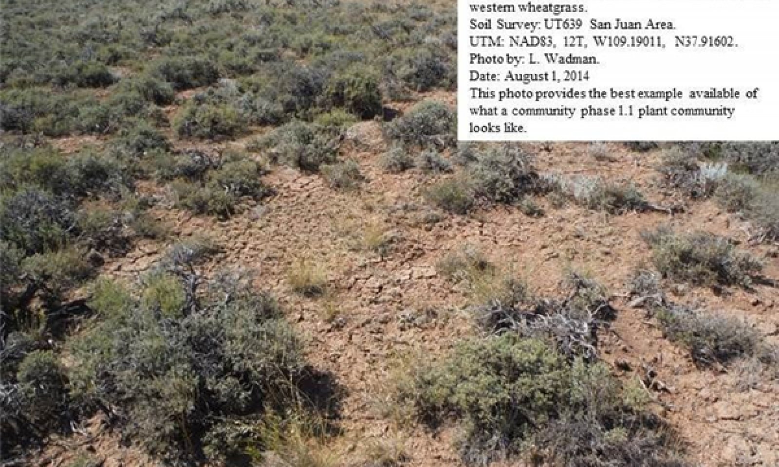
Trigger: The establishment of invasive plant species.Community 1.1
Low Sagebrush, Perennial Grass Community Phase.
Figure 6. Community Phase 1.1
This phase of the ecological site is characterized by a shrub layer dominated by Low sagebrush. A wide array of other shrubs including fourwing saltbush and winterfat are also commonly present. Indian ricegrass and western wheatgrass dominate the herbaceous layer. Other commonly occurring herbaceous species include James galleta, needle-and-thread, blue grama and scarlet globemallow. The appearance of most forbs is episodic in nature and is closely tied to precipitation events.
Air dry weight is approximately 50 percent shrubs, 10 percent forbs, and 40 percent grasses. Bare ground is variable (2-55%) depending on biological crust cover, which is also variable (0-64%).
The following tables present a typical example of the vegetative floristics of a community phase 1.1 plant community.Figure 7. Annual production by plant type (representative values) or group (midpoint values)
Table 5. Annual production by plant type
Plant type Low
(lb/acre)Representative value
(lb/acre)High
(lb/acre)Shrub/Vine 250 370 525 Grass/Grasslike 225 340 475 Forb 25 40 50 Total 500 750 1050 Table 6. Ground cover
Tree foliar cover 0% Shrub/vine/liana foliar cover 30-30% Grass/grasslike foliar cover 30-30% Forb foliar cover 0-10% Non-vascular plants 0% Biological crusts 0% Litter 0% Surface fragments >0.25" and <=3" 0% Surface fragments >3" 0% Bedrock 0% Water 0% Bare ground 0% Table 7. Canopy structure (% cover)
Height Above Ground (ft) Tree Shrub/Vine Grass/
GrasslikeForb <0.5 – – – – >0.5 <= 1 – – 29-31% 4-6% >1 <= 2 – 29-31% – – >2 <= 4.5 – – – – >4.5 <= 13 – – – – >13 <= 40 – – – – >40 <= 80 – – – – >80 <= 120 – – – – >120 – – – – Community 1.2
Low Sagebrush, Western Wheatgrass Community Phase.
Figure 8. Community Phase 1.2
This community phase of the ecological site is characterized by a shrub layer dominated by Low sagebrush. A wide array of other shrubs including fourwing saltbush and winterfat may also be present. Western wheatgrass dominates the herbaceous layer, Indian ricegrass and other perennial bunchgrasses are much reduced. James galleta, blue grama and scarlet globemallow may increase.
Air dry weight is approximately 40 percent shrubs, 10 percent forbs, and 50 percent grasses. Bare ground is variable (2-55%) depending on biological crust cover, which is also variable (0-64%).
The following tables present a typical example of the vegetative floristics of a community phase 1.2 plant community.Figure 9. Annual production by plant type (representative values) or group (midpoint values)
Table 8. Annual production by plant type
Plant type Low
(lb/acre)Representative value
(lb/acre)High
(lb/acre)Shrub/Vine 250 370 525 Grass/Grasslike 225 340 475 Forb 25 40 50 Total 500 750 1050 Table 9. Ground cover
Tree foliar cover 0% Shrub/vine/liana foliar cover 30-30% Grass/grasslike foliar cover 30-30% Forb foliar cover 0-10% Non-vascular plants 0% Biological crusts 0% Litter 0% Surface fragments >0.25" and <=3" 0% Surface fragments >3" 0% Bedrock 0% Water 0% Bare ground 0% Table 10. Canopy structure (% cover)
Height Above Ground (ft) Tree Shrub/Vine Grass/
GrasslikeForb <0.5 – – – – >0.5 <= 1 – – 29-31% 4-6% >1 <= 2 – 29-31% – – >2 <= 4.5 – – – – >4.5 <= 13 – – – – >13 <= 40 – – – – >40 <= 80 – – – – >80 <= 120 – – – – >120 – – – – Pathway 1.1A
Community 1.1 to 1.2
Low Sagebrush, Perennial Grass Community Phase.
Low Sagebrush, Western Wheatgrass Community Phase.This pathway describes the affects of any combination of recent fire activity and dry weather periods which can decrease the amount perennial bunchgrass. Improper livestock management and heavy wildlife browsing can also allow for decreased vigor in these bunchgrass species.
Pathway 1.2A
Community 1.2 to 1.1
Low Sagebrush, Western Wheatgrass Community Phase.
Low Sagebrush, Perennial Grass Community Phase.This pathway describes the affects of any combination of no recent fire activity and wet weather periods which will increase the amount of herbaceous vegetation. Good livestock management and moderate wildlife browsing will allow for improved vigor in perennial bunchgrasses and other herbaceous species.
State 2
Current Potential StateThe Current Potential State is similar to the Reference Sate except that non-native species are now present. This state describes the plant communities that may or have become established on this ecological site under various successional sequences and disturbance conditions. Low sagebrush dominates the shrub layer. Fourwing saltbush and winterfat are other common shrub species. Crested wheatgrass dominates the herbaceous layer. Indian ricegrass and James galleta and other perennial grasses and forbs are commonly found. Native grasses, forbs, and shrubs may produce a significant amount of the sites production. Cheatgrass, Russian thistle, redstem storksbill, various mustard species and other non-native species are present on the site and under certain circumstances, may visually dominate the sites aspect.
The primary disturbance mechanisms are the shrub layer density; the amount of invasive species present; weather fluctuations; and fire. The current potential state is still self-sustaining but may be losing its resistance to change due to the impact of disturbances with less resilience following those disturbances.
Definitions:
Current Potential State: Plant communities influenced by shrub canopy density, long term weather fluctuations, and periodic fire. Invasive species are present in various amounts.
Indicators: A community dominated by low sagebrush, crested wheatgrass and Indian ricegrass. The density of the shrub canopy determines the amount and composition of the other native and introduced grasses and forbs that may be present.
Feedbacks: Natural fluctuations in weather patterns that allow for a self sustaining shrub and native grass community. Prolonged drought, more frequent fires, and/or other disturbances that may allow for the increase of invasive species.
At-risk Community Phase: All communities are at risk when native plants are stressed and nutrients become available for invasive plants to increase.
Trigger: A reduction of perennial grass and forb species combined with an increase of invasive plant species.Community 2.1
Low Sagebrush, Crested Wheatgrass, Invasive Weed Community Phase.
Figure 10. Community Phase 2.1
This community phase of the ecological site is characterized by a shrub layer dominated by Low sagebrush. A other shrubs including fourwing saltbush and winterfat may also be present. Crested and western wheatgrass dominate the herbaceous layer, Indian ricegrass and other perennial bunchgrasses are much reduced. James galleta, blue grama and scarlet globemallow may increase. Invasive weeds including cheatgrass, six weeks fescue, Russian thistle and various mustard species are now present in the plant community.
Air dry weight is approximately 50 percent shrubs, 5 percent forbs, and 30 percent grasses. Bare ground is variable (2-55%) depending on biological crust cover, which is also variable (0-64%).
The following tables present a typical example of the vegetative floristics of a community phase 2.1 plant community.Figure 11. Annual production by plant type (representative values) or group (midpoint values)
Table 11. Annual production by plant type
Plant type Low
(lb/acre)Representative value
(lb/acre)High
(lb/acre)Shrub/Vine 250 370 525 Grass/Grasslike 225 340 475 Forb 25 40 50 Total 500 750 1050 Table 12. Ground cover
Tree foliar cover 0% Shrub/vine/liana foliar cover 30-30% Grass/grasslike foliar cover 30-30% Forb foliar cover 0-10% Non-vascular plants 0% Biological crusts 0% Litter 0% Surface fragments >0.25" and <=3" 0% Surface fragments >3" 0% Bedrock 0% Water 0% Bare ground 0% Table 13. Canopy structure (% cover)
Height Above Ground (ft) Tree Shrub/Vine Grass/
GrasslikeForb <0.5 – – – – >0.5 <= 1 – – 29-31% 4-6% >1 <= 2 – 29-31% – – >2 <= 4.5 – – – – >4.5 <= 13 – – – – >13 <= 40 – – – – >40 <= 80 – – – – >80 <= 120 – – – – >120 – – – – Community 2.2
Low Sagebrush, Invasive Weed Community Phase.
Figure 12. Community Phase 2.2
This community phase of the ecological site is characterized by a shrub layer dominated by Low sagebrush. Other shrubs including fourwing saltbush and winterfat may be present in limited amounts. Western wheatgrass, Indian ricegrass and other perennial grasses are much reduced. James galleta, blue grama and scarlet globemallow may increase. Invasive weeds including cheatgrass, six weeks fescue, Russian thistle and various mustard species are now present and may dominate the herbaceous layer in the plant community.
Air dry weight is approximately 90 percent shrubs, 5 percent forbs, and 5 percent grasses. Bare ground is variable (2-55%) depending on biological crust cover, which is also variable (0-64%).
The following tables present a typical example of the vegetative floristics of a community phase 2.2 plant community.Figure 13. Annual production by plant type (representative values) or group (midpoint values)
Table 14. Annual production by plant type
Plant type Low
(lb/acre)Representative value
(lb/acre)High
(lb/acre)Shrub/Vine 250 370 525 Grass/Grasslike 225 340 475 Forb 25 40 50 Total 500 750 1050 Table 15. Ground cover
Tree foliar cover 0% Shrub/vine/liana foliar cover 30-30% Grass/grasslike foliar cover 30-30% Forb foliar cover 0-10% Non-vascular plants 0% Biological crusts 0% Litter 0% Surface fragments >0.25" and <=3" 0% Surface fragments >3" 0% Bedrock 0% Water 0% Bare ground 0% Table 16. Canopy structure (% cover)
Height Above Ground (ft) Tree Shrub/Vine Grass/
GrasslikeForb <0.5 – – – – >0.5 <= 1 – – 29-31% 4-6% >1 <= 2 – 29-31% – – >2 <= 4.5 – – – – >4.5 <= 13 – – – – >13 <= 40 – – – – >40 <= 80 – – – – >80 <= 120 – – – – >120 – – – – Pathway 2.1A
Community 2.1 to 2.2
Low Sagebrush, Crested Wheatgrass, Invasive Weed Community Phase.
Low Sagebrush, Invasive Weed Community Phase.This pathway describes the affects of any combination of recent fire activity and long term dry weather periods which can decrease the amount perennial grass. Improper livestock management and heavy wildlife browsing for long periods can also allow for decreased vigor in these bunchgrass species. Invasive weeds can increase significantly during this time.
Pathway 2.2A
Community 2.2 to 2.1
Low Sagebrush, Invasive Weed Community Phase.
Low Sagebrush, Crested Wheatgrass, Invasive Weed Community Phase.This pathway describes the affects of any combination of lack of recent fire activity and wet weather periods which will increase the amount of herbaceous vegetation. Good livestock management and moderate wildlife browsing will allow for improved vigor in perennial bunchgrasses and other herbaceous species. Range seeding can increase herbaceous vegetation where insufficient native species are present.
State 3
Altered StateThe Altered State of this ecological site has been mechanically disked to remove all perennial vegetation. The site is then typically converted to dry cropland or seeded to introduced range grasses such as crested wheatgrass or intermediate wheatgrass. Where cropland has been abandoned or range seedings fail, invasive weeds may dominate the site. This state has lost significant resistance to natural disturbances.
Terminology:
Current Potential State: Plant communities influenced by man influenced events including disking, rodent activity and climatic fluctuations.
Indicators: Non-native species are now present in all plant communities.
Feedbacks: Extended drought and other disturbance that changes the ecological dynamics of the site.
At-risk Community Phase: All communities are at risk.
Trigger: Disturbance that facilitates the dominance of invasive forbs and/or grasses.Community 3.1
Disked, Rangeland Seeding Community Phase.
Figure 14. Community Phase 3.1
This community phase of the ecological site has been deep disked to remove all vegetation. The site has been seeded to introduced rangeland grasses including crested wheatgrass, intermediate wheatgrass or Russian wildrye. A few native perennial grasses including Indian ricegrass, James galleta and blue grama may still be present. Invasive species including Russian thistle, cheatgrass, redstem storksbill and various mustard species may also be present in small amounts.
Air dry weight is approximately 5 percent shrubs, 5 percent forbs, and 90 percent grasses. Bare ground is variable (2-55%) depending on biological crust cover, which is also variable (0-64%).
The following tables present a typical example of the vegetative floristics of a community phase 3.1 plant community.Figure 15. Annual production by plant type (representative values) or group (midpoint values)
Table 17. Annual production by plant type
Plant type Low
(lb/acre)Representative value
(lb/acre)High
(lb/acre)Shrub/Vine 250 370 525 Grass/Grasslike 225 340 475 Forb 25 40 50 Total 500 750 1050 Table 18. Ground cover
Tree foliar cover 0% Shrub/vine/liana foliar cover 30-30% Grass/grasslike foliar cover 30-30% Forb foliar cover 0-10% Non-vascular plants 0% Biological crusts 0% Litter 0% Surface fragments >0.25" and <=3" 0% Surface fragments >3" 0% Bedrock 0% Water 0% Bare ground 0% Table 19. Canopy structure (% cover)
Height Above Ground (ft) Tree Shrub/Vine Grass/
GrasslikeForb <0.5 – – – – >0.5 <= 1 – – 29-31% 4-6% >1 <= 2 – 29-31% – – >2 <= 4.5 – – – – >4.5 <= 13 – – – – >13 <= 40 – – – – >40 <= 80 – – – – >80 <= 120 – – – – >120 – – – – Community 3.2
Dry Cropland Community Phase.
Figure 16. Community Phase 3.2
This community phase of the ecological site has been deep disked to remove all vegetation. The site has been converted from rangeland to dry cropland. the most commonly grown crops are wheat and barley.
Table 20. Canopy structure (% cover)
Height Above Ground (ft) Tree Shrub/Vine Grass/
GrasslikeForb <0.5 – – – – >0.5 <= 1 – – 29-31% 4-6% >1 <= 2 – 29-31% – – >2 <= 4.5 – – – – >4.5 <= 13 – – – – >13 <= 40 – – – – >40 <= 80 – – – – >80 <= 120 – – – – >120 – – – – Pathway 3.1A
Community 3.1 to 3.2
Disked, Rangeland Seeding Community Phase.
Dry Cropland Community Phase.This pathway describes the affects of deep disking to remove all site vegetation. Site in now being used for dry cropland.
Pathway 3.2A
Community 3.2 to 3.1
Dry Cropland Community Phase.
Disked, Rangeland Seeding Community Phase.This pathway describes the affects of range seeding on dry cropland that is being converted to seeded rangeland. Land being placed into the Conservation Reserve Program (CRP) would be an example of this pathway.
Transition T1A
State 1 to 2This pathway describes the affects of a long term drought that does not allow for sufficient precipitation to support herbaceous species and/or long periods without fire. Heavy wildlife browsing can allow for non-palatable shrubs to increase. Heavy livestock grazing will reduce palatable herbaceous species. Invasive weedy species may invade plant communities.
Transition T2A
State 2 to 3This pathway describes the affects of disking to remove unwanted vegetation. Site is converted into seeded rangeland or dry cropland.
Additional community tables
Table 21. Community 1.1 plant community composition
Group Common name Symbol Scientific name Annual production () Foliar cover (%) Grass/Grasslike1 Dominant Grasses 180–320 Indian ricegrass ACHY Achnatherum hymenoides 70–120 – western wheatgrass PASM Pascopyrum smithii 70–120 – James' galleta PLJA Pleuraphis jamesii 30–60 – 2 Sub-Dominant Grasses 70–140 Grass, annual 2GA Grass, annual 20–40 – Grass, perennial 2GP Grass, perennial 20–40 – blue grama BOGR2 Bouteloua gracilis 20–40 – needle and thread HECOC8 Hesperostipa comata ssp. comata 20–40 – prairie Junegrass KOMA Koeleria macrantha 10–20 – Kentucky bluegrass POPR Poa pratensis 10–20 – Sandberg bluegrass POSE Poa secunda 10–20 – squirreltail ELEL5 Elymus elymoides 10–20 – Letterman's needlegrass ACLE9 Achnatherum lettermanii 10–20 – Forb3 Forbs 90–225 Forb, annual 2FA Forb, annual 20–40 – Forb, perennial 2FP Forb, perennial 20–40 – tapertip onion ALAC4 Allium acuminatum 10–20 – woolly locoweed ASMO7 Astragalus mollissimus 10–20 – sego lily CANU3 Calochortus nuttallii 10–20 – wavyleaf thistle CIUN Cirsium undulatum 10–20 – Wright's bird's beak COWR2 Cordylanthus wrightii 10–20 – basin fleabane ERPU9 Erigeron pulcherrimus 10–20 – redroot buckwheat ERRA3 Eriogonum racemosum 10–20 – mountain pepperweed LEMO2 Lepidium montanum 10–20 – silky lupine LUSE4 Lupinus sericeus 10–20 – hoary tansyaster MACA2 Machaeranthera canescens 10–20 – lobeleaf groundsel PAMU11 Packera multilobata 10–20 – spiny phlox PHHO Phlox hoodii 10–20 – old-man-in-the-Spring SEVU Senecio vulgaris 10–20 – scarlet globemallow SPCO Sphaeralcea coccinea 10–20 – gooseberryleaf globemallow SPGR2 Sphaeralcea grossulariifolia 10–20 – Shrub/Vine4 Dominant Shrubs 220–360 little sagebrush ARAR8 Artemisia arbuscula 150–250 – fourwing saltbush ATCA2 Atriplex canescens 30–60 – winterfat KRLA2 Krascheninnikovia lanata 30–60 – 5 Sub-Dominant Shrubs 70–200 Shrub (>.5m) 2SHRUB Shrub (>.5m) 30–60 – mountain big sagebrush ARTRV Artemisia tridentata ssp. vaseyana 20–40 – antelope bitterbrush PUTR2 Purshia tridentata 20–40 – mountain snowberry SYOR2 Symphoricarpos oreophilus 10–20 – alderleaf mountain mahogany CEMO2 Cercocarpus montanus 10–20 – yellow rabbitbrush CHVI8 Chrysothamnus viscidiflorus 10–20 – rubber rabbitbrush ERNAN5 Ericameria nauseosa ssp. nauseosa var. nauseosa 10–20 – cushion buckwheat EROV Eriogonum ovalifolium 10–20 – bastardsage ERWR Eriogonum wrightii 10–20 – broom snakeweed GUSA2 Gutierrezia sarothrae 10–20 – rock goldenrod PEPU7 Petradoria pumila 10–20 – wild crab apple PERA4 Peraphyllum ramosissimum 10–20 – prairie sagewort ARFR4 Artemisia frigida 10–20 – Table 22. Community 1.2 plant community composition
Group Common name Symbol Scientific name Annual production () Foliar cover (%) Grass/Grasslike1 Dominant Grasses 180–320 western wheatgrass PASM Pascopyrum smithii 120–180 – James' galleta PLJA Pleuraphis jamesii 30–60 – Indian ricegrass ACHY Achnatherum hymenoides 30–60 – 2 Sub-Dominant Grasses 70–140 Grass, annual 2GA Grass, annual 20–40 – Grass, perennial 2GP Grass, perennial 20–40 – blue grama BOGR2 Bouteloua gracilis 20–40 – needle and thread HECOC8 Hesperostipa comata ssp. comata 20–40 – prairie Junegrass KOMA Koeleria macrantha 10–20 – Kentucky bluegrass POPR Poa pratensis 10–20 – Sandberg bluegrass POSE Poa secunda 10–20 – squirreltail ELEL5 Elymus elymoides 10–20 – Letterman's needlegrass ACLE9 Achnatherum lettermanii 10–20 – Forb3 Forbs 90–225 Forb, annual 2FA Forb, annual 20–40 – Forb, perennial 2FP Forb, perennial 20–40 – tapertip onion ALAC4 Allium acuminatum 10–20 – woolly locoweed ASMO7 Astragalus mollissimus 10–20 – sego lily CANU3 Calochortus nuttallii 10–20 – wavyleaf thistle CIUN Cirsium undulatum 10–20 – Wright's bird's beak COWR2 Cordylanthus wrightii 10–20 – basin fleabane ERPU9 Erigeron pulcherrimus 10–20 – redroot buckwheat ERRA3 Eriogonum racemosum 10–20 – mountain pepperweed LEMO2 Lepidium montanum 10–20 – silky lupine LUSE4 Lupinus sericeus 10–20 – hoary tansyaster MACA2 Machaeranthera canescens 10–20 – lobeleaf groundsel PAMU11 Packera multilobata 10–20 – spiny phlox PHHO Phlox hoodii 10–20 – old-man-in-the-Spring SEVU Senecio vulgaris 10–20 – scarlet globemallow SPCO Sphaeralcea coccinea 10–20 – gooseberryleaf globemallow SPGR2 Sphaeralcea grossulariifolia 10–20 – Shrub/Vine4 Dominant Shrubs 220–360 little sagebrush ARAR8 Artemisia arbuscula 150–250 – fourwing saltbush ATCA2 Atriplex canescens 30–60 – winterfat KRLA2 Krascheninnikovia lanata 30–60 – 5 Sub-Dominant Shrubs 70–200 Shrub (>.5m) 2SHRUB Shrub (>.5m) 30–60 – mountain big sagebrush ARTRV Artemisia tridentata ssp. vaseyana 20–40 – antelope bitterbrush PUTR2 Purshia tridentata 20–40 – mountain snowberry SYOR2 Symphoricarpos oreophilus 10–20 – alderleaf mountain mahogany CEMO2 Cercocarpus montanus 10–20 – yellow rabbitbrush CHVI8 Chrysothamnus viscidiflorus 10–20 – rubber rabbitbrush ERNAN5 Ericameria nauseosa ssp. nauseosa var. nauseosa 10–20 – cushion buckwheat EROV Eriogonum ovalifolium 10–20 – bastardsage ERWR Eriogonum wrightii 10–20 – broom snakeweed GUSA2 Gutierrezia sarothrae 10–20 – rock goldenrod PEPU7 Petradoria pumila 10–20 – wild crab apple PERA4 Peraphyllum ramosissimum 10–20 – prairie sagewort ARFR4 Artemisia frigida 10–20 – Table 23. Community 2.1 plant community composition
Group Common name Symbol Scientific name Annual production () Foliar cover (%) Grass/Grasslike1 Dominant Grasses 180–320 western wheatgrass PASM Pascopyrum smithii 60–90 – James' galleta PLJA Pleuraphis jamesii 30–60 – Indian ricegrass ACHY Achnatherum hymenoides 30–60 – cheatgrass BRTE Bromus tectorum 30–60 – sixweeks fescue VUOC Vulpia octoflora 20–40 – 2 Sub-Dominant Grasses 70–140 Grass, annual 2GA Grass, annual 20–40 – Grass, perennial 2GP Grass, perennial 20–40 – blue grama BOGR2 Bouteloua gracilis 20–40 – needle and thread HECOC8 Hesperostipa comata ssp. comata 20–40 – prairie Junegrass KOMA Koeleria macrantha 10–20 – Kentucky bluegrass POPR Poa pratensis 10–20 – Sandberg bluegrass POSE Poa secunda 10–20 – squirreltail ELEL5 Elymus elymoides 10–20 – Letterman's needlegrass ACLE9 Achnatherum lettermanii 10–20 – Forb3 Forbs 90–225 lambsquarters CHAL7 Chenopodium album 30–60 – herb sophia DESO2 Descurainia sophia 30–60 – Russian thistle SAKA Salsola kali 30–60 – curlycup gumweed GRSQ Grindelia squarrosa 20–40 – common sunflower HEAN3 Helianthus annuus 20–40 – Forb, annual 2FA Forb, annual 20–40 – Forb, perennial 2FP Forb, perennial 20–40 – tapertip onion ALAC4 Allium acuminatum 10–20 – woolly locoweed ASMO7 Astragalus mollissimus 10–20 – sego lily CANU3 Calochortus nuttallii 10–20 – basin fleabane ERPU9 Erigeron pulcherrimus 10–20 – redroot buckwheat ERRA3 Eriogonum racemosum 10–20 – wavyleaf thistle CIUN Cirsium undulatum 10–20 – Wright's bird's beak COWR2 Cordylanthus wrightii 10–20 – mountain pepperweed LEMO2 Lepidium montanum 10–20 – silky lupine LUSE4 Lupinus sericeus 10–20 – hoary tansyaster MACA2 Machaeranthera canescens 10–20 – lobeleaf groundsel PAMU11 Packera multilobata 10–20 – spiny phlox PHHO Phlox hoodii 10–20 – old-man-in-the-Spring SEVU Senecio vulgaris 10–20 – scarlet globemallow SPCO Sphaeralcea coccinea 10–20 – gooseberryleaf globemallow SPGR2 Sphaeralcea grossulariifolia 10–20 – Shrub/Vine4 Dominant Shrubs 220–360 little sagebrush ARAR8 Artemisia arbuscula 150–250 – fourwing saltbush ATCA2 Atriplex canescens 30–60 – winterfat KRLA2 Krascheninnikovia lanata 30–60 – 5 Sub-Dominant Shrubs 70–200 Shrub (>.5m) 2SHRUB Shrub (>.5m) 30–60 – mountain big sagebrush ARTRV Artemisia tridentata ssp. vaseyana 20–40 – antelope bitterbrush PUTR2 Purshia tridentata 20–40 – mountain snowberry SYOR2 Symphoricarpos oreophilus 10–20 – alderleaf mountain mahogany CEMO2 Cercocarpus montanus 10–20 – yellow rabbitbrush CHVI8 Chrysothamnus viscidiflorus 10–20 – rubber rabbitbrush ERNAN5 Ericameria nauseosa ssp. nauseosa var. nauseosa 10–20 – cushion buckwheat EROV Eriogonum ovalifolium 10–20 – bastardsage ERWR Eriogonum wrightii 10–20 – broom snakeweed GUSA2 Gutierrezia sarothrae 10–20 – rock goldenrod PEPU7 Petradoria pumila 10–20 – wild crab apple PERA4 Peraphyllum ramosissimum 10–20 – prairie sagewort ARFR4 Artemisia frigida 10–20 – Table 24. Community 2.2 plant community composition
Group Common name Symbol Scientific name Annual production () Foliar cover (%) Grass/Grasslike1 Dominant Grasses 180–320 western wheatgrass PASM Pascopyrum smithii 60–90 – James' galleta PLJA Pleuraphis jamesii 30–60 – Indian ricegrass ACHY Achnatherum hymenoides 30–60 – cheatgrass BRTE Bromus tectorum 30–60 – sixweeks fescue VUOC Vulpia octoflora 20–40 – 2 Sub-Dominant Grasses 70–140 Grass, annual 2GA Grass, annual 20–40 – Grass, perennial 2GP Grass, perennial 20–40 – blue grama BOGR2 Bouteloua gracilis 20–40 – needle and thread HECOC8 Hesperostipa comata ssp. comata 20–40 – prairie Junegrass KOMA Koeleria macrantha 10–20 – Kentucky bluegrass POPR Poa pratensis 10–20 – Sandberg bluegrass POSE Poa secunda 10–20 – squirreltail ELEL5 Elymus elymoides 10–20 – Letterman's needlegrass ACLE9 Achnatherum lettermanii 10–20 – Forb3 Forbs 90–225 lambsquarters CHAL7 Chenopodium album 30–60 – herb sophia DESO2 Descurainia sophia 30–60 – Russian thistle SAKA Salsola kali 30–60 – curlycup gumweed GRSQ Grindelia squarrosa 20–40 – common sunflower HEAN3 Helianthus annuus 20–40 – Forb, annual 2FA Forb, annual 20–40 – Forb, perennial 2FP Forb, perennial 20–40 – tapertip onion ALAC4 Allium acuminatum 10–20 – woolly locoweed ASMO7 Astragalus mollissimus 10–20 – sego lily CANU3 Calochortus nuttallii 10–20 – basin fleabane ERPU9 Erigeron pulcherrimus 10–20 – redroot buckwheat ERRA3 Eriogonum racemosum 10–20 – wavyleaf thistle CIUN Cirsium undulatum 10–20 – Wright's bird's beak COWR2 Cordylanthus wrightii 10–20 – mountain pepperweed LEMO2 Lepidium montanum 10–20 – silky lupine LUSE4 Lupinus sericeus 10–20 – hoary tansyaster MACA2 Machaeranthera canescens 10–20 – lobeleaf groundsel PAMU11 Packera multilobata 10–20 – spiny phlox PHHO Phlox hoodii 10–20 – old-man-in-the-Spring SEVU Senecio vulgaris 10–20 – scarlet globemallow SPCO Sphaeralcea coccinea 10–20 – gooseberryleaf globemallow SPGR2 Sphaeralcea grossulariifolia 10–20 – Shrub/Vine4 Dominant Shrubs 220–360 little sagebrush ARAR8 Artemisia arbuscula 150–250 – fourwing saltbush ATCA2 Atriplex canescens 30–60 – winterfat KRLA2 Krascheninnikovia lanata 30–60 – 5 Sub-Dominant Shrubs 70–200 Shrub (>.5m) 2SHRUB Shrub (>.5m) 30–60 – mountain big sagebrush ARTRV Artemisia tridentata ssp. vaseyana 20–40 – antelope bitterbrush PUTR2 Purshia tridentata 20–40 – mountain snowberry SYOR2 Symphoricarpos oreophilus 10–20 – alderleaf mountain mahogany CEMO2 Cercocarpus montanus 10–20 – yellow rabbitbrush CHVI8 Chrysothamnus viscidiflorus 10–20 – rubber rabbitbrush ERNAN5 Ericameria nauseosa ssp. nauseosa var. nauseosa 10–20 – cushion buckwheat EROV Eriogonum ovalifolium 10–20 – bastardsage ERWR Eriogonum wrightii 10–20 – broom snakeweed GUSA2 Gutierrezia sarothrae 10–20 – rock goldenrod PEPU7 Petradoria pumila 10–20 – wild crab apple PERA4 Peraphyllum ramosissimum 10–20 – prairie sagewort ARFR4 Artemisia frigida 10–20 – Table 25. Community 3.1 plant community composition
Group Common name Symbol Scientific name Annual production () Foliar cover (%) Grass/Grasslike1 Dominant Grasses 180–320 crested wheatgrass AGCR Agropyron cristatum 100–300 – Russian wildrye PSJU3 Psathyrostachys juncea 100–300 – intermediate wheatgrass THIN6 Thinopyrum intermedium 100–300 – western wheatgrass PASM Pascopyrum smithii 60–90 – James' galleta PLJA Pleuraphis jamesii 30–60 – cheatgrass BRTE Bromus tectorum 30–60 – Indian ricegrass ACHY Achnatherum hymenoides 30–60 – sixweeks fescue VUOC Vulpia octoflora 20–40 – 2 Sub-Dominant Grasses 70–140 Grass, annual 2GA Grass, annual 20–40 – Grass, perennial 2GP Grass, perennial 20–40 – needle and thread HECOC8 Hesperostipa comata ssp. comata 20–40 – blue grama BOGR2 Bouteloua gracilis 20–40 – squirreltail ELEL5 Elymus elymoides 10–20 – prairie Junegrass KOMA Koeleria macrantha 10–20 – Kentucky bluegrass POPR Poa pratensis 10–20 – Sandberg bluegrass POSE Poa secunda 10–20 – Letterman's needlegrass ACLE9 Achnatherum lettermanii 10–20 – Forb3 Forbs 90–120 lambsquarters CHAL7 Chenopodium album 30–60 – herb sophia DESO2 Descurainia sophia 30–60 – Russian thistle SAKA Salsola kali 30–60 – curlycup gumweed GRSQ Grindelia squarrosa 20–40 – common sunflower HEAN3 Helianthus annuus 20–40 – Forb, annual 2FA Forb, annual 20–40 – Forb, perennial 2FP Forb, perennial 20–40 – tapertip onion ALAC4 Allium acuminatum 10–20 – woolly locoweed ASMO7 Astragalus mollissimus 10–20 – sego lily CANU3 Calochortus nuttallii 10–20 – basin fleabane ERPU9 Erigeron pulcherrimus 10–20 – redroot buckwheat ERRA3 Eriogonum racemosum 10–20 – wavyleaf thistle CIUN Cirsium undulatum 10–20 – Wright's bird's beak COWR2 Cordylanthus wrightii 10–20 – mountain pepperweed LEMO2 Lepidium montanum 10–20 – silky lupine LUSE4 Lupinus sericeus 10–20 – hoary tansyaster MACA2 Machaeranthera canescens 10–20 – lobeleaf groundsel PAMU11 Packera multilobata 10–20 – spiny phlox PHHO Phlox hoodii 10–20 – old-man-in-the-Spring SEVU Senecio vulgaris 10–20 – scarlet globemallow SPCO Sphaeralcea coccinea 10–20 – gooseberryleaf globemallow SPGR2 Sphaeralcea grossulariifolia 10–20 – Shrub/Vine4 Dominant Shrubs 60–90 little sagebrush ARAR8 Artemisia arbuscula 30–60 – fourwing saltbush ATCA2 Atriplex canescens 30–60 – winterfat KRLA2 Krascheninnikovia lanata 30–60 – 5 Sub-Dominant Shrubs 40–80 Shrub (>.5m) 2SHRUB Shrub (>.5m) 30–60 – antelope bitterbrush PUTR2 Purshia tridentata 20–40 – mountain big sagebrush ARTRV Artemisia tridentata ssp. vaseyana 20–40 – alderleaf mountain mahogany CEMO2 Cercocarpus montanus 10–20 – yellow rabbitbrush CHVI8 Chrysothamnus viscidiflorus 10–20 – rubber rabbitbrush ERNAN5 Ericameria nauseosa ssp. nauseosa var. nauseosa 10–20 – cushion buckwheat EROV Eriogonum ovalifolium 10–20 – bastardsage ERWR Eriogonum wrightii 10–20 – broom snakeweed GUSA2 Gutierrezia sarothrae 10–20 – rock goldenrod PEPU7 Petradoria pumila 10–20 – wild crab apple PERA4 Peraphyllum ramosissimum 10–20 – mountain snowberry SYOR2 Symphoricarpos oreophilus 10–20 – prairie sagewort ARFR4 Artemisia frigida 10–20 – Table 26. Community 3.2 plant community composition
Group Common name Symbol Scientific name Annual production () Foliar cover (%) Interpretations
Animal community
--Livestock and Wildlife Grazing--
This site provides good grazing conditions for livestock and wildlife during spring, summer, and fall when in good ecological condition due to accessibility and nutritious forage. However, this site may lack the natural perennial water sources, which can influence the suitability for livestock and wildlife grazing. Care should be taken to maintain the native perennial grasses and shrubs due to the poor suitability for re-seeding or restoring this site. Reseeding and/or restoration are possible, but the major limiting factor is the lack of precipitation at critical times. This site may occur in mule deer and elk habitat; however in many places the populations will be small and have little grazing impact on the site.
The plant community is generally an equal mixture of shrubs and grasses. Shrubs including low sagebrush, antelope bitterbrush, and mountain big sagebrush provide good browse for cattle, sheep, goats, mule deer and elk. This shrub is palatable and is preferred over the other sagebrush species by mule deer. Livestock also will readily eat low sagebrush especially in the spring, fall, and winter. The presence of grasses, including Indian ricegrass, western wheatgrass, blue grama, and bottlebrush squirreltail provide desirable grazing conditions for all classes of livestock and wildlife. Forb composition and annual production depends primarily on precipitation amounts and thus is challenging to use in livestock grazing management decisions. However, forb composition should be monitored for species diversity, as well as poisonous or injurious plant communities which may be detrimental to livestock if grazed. Before making specific grazing management recommendations, an onsite evaluation must be made.Hydrological functions
The soils associated with this ecological site are generally in Hydrologic Soil Group D due to the shallow depth to a restrictive layer(NRCS National Engineering Handbook). Once these soils become saturated, run off potential is high. Hydrological groups are used in equations that estimate runoff from rainfall. These estimates are needed for solving hydrologic problems that arise in planning watershed-protection and flood-prevention projects and for designing structures for the use, control and disposal of water. Heavy grazing can alter the hydrology by decreasing plant cover and increasing bare ground. Fire can also affect hydrology, but its affect is variable. Fire intensity, fuel type, soil, climate, and topography can each have different influences. Fires can increase areas of bare ground and hydrophobic layers that reduce infiltration and increase runoff (National Range and Pasture Handbook, 2003).
Recreational uses
This site has fair to good values for aesthetics and natural beauty. Hunting is fair for deer, upland game, and rabbits. Potential is poor to fair for camping and picnicking on the basis of vegetation.
Wood products
None
Other information
--Poisonous/Toxic Plant Communities--
Toxic plants associated with this site include woolly locoweed and silky lupine. Woolly locoweed is toxic to all classes of livestock and wildlife. Locoweed is palatable and has similar nutrient value to alfalfa, which may cause animals to consume it even when other forage is available. Locoweed contains swainsonine (indolizdine alkaloid) and is poisonous at all stages of growth. Poisoning will become evident after 2-3 weeks of continuous grazing and is associated with 4 major symptoms: 1) neurological damage, 2) emaciation, 3) reproductive failure and abortion, and 4) congestive heart failure linked with “high mountain disease”. Lupine toxicity depends primarily on species—many lupines are nontoxic. The toxic compounds, quinolizidine and piperlizidine alkaloids, are found in all part of the plants, during all phases. Lupine poisoning is associated with 2 syndromes: 1) crooked calf disease and 2) neurological disease. Crooked calf disease is characterized by calves being born with skeletal deformities and caused by cows consuming toxic levels of lupines between 40 and 70 days gestation. The neurological diseases is marked by include muscle tremors, labored breathing, coma, and death and is caused by animals grazing lupines at anytime.
Potentially toxic plants associated with this site include some buckwheat species, and mountain big sagebrush. Some buckwheat species may accumulate selenium, but only when growing on selenium enriched soils. These plants, when consumed will cause alkali disease or chronic selenosis, which affects all classes of livestock (excluding goats). Typically animals consuming 5-50 ppm selenium will develop chronic selenosis and animals consuming greater than 50 ppm selenium will develop acute selenosis. Clinical signs include lameness, soughing of the hoof, hair loss, blindness, and aimless wondering. Horses tend to develop what is called a “bob” tail or “roached” main due to breakage of the long hairs. Mountain big sagebrush contains sesquiterpene lactones and monoterpenes which have been suspected of being toxic to sheep. An experimental dosage of ¾ lbs of big sagebrush fed to sheep for three days was found to be lethal.
Russian thistle is an invasive toxic plant, causing nitrate and to a lesser extent oxalate poisoning, which affects all classes of livestock. The buildup of nitrates in these plants is highly dependent upon environmental factors, such as after a rain storm during a drought, cool/cloudy days, and soils high in nitrogen and low in sulfur and phosphorus, all which cause increased nitrate accumulation. Nitrate collects in the stems and can persist throughout the growing season. Clinical signs of nitrate poisoning include drowsiness, weakness, muscular tremors, increased heart and respiratory rates, staggering gait, and death. Conversely, oxalate poisoning causes kidney failure; clinical signs include muscle tremors, tetany, weakness, and depression. Poisoning generally occurs when livestock consume and are not accustomed to grazing oxalate-containing plants. Animals with prior exposure to oxalates have increased numbers of oxalate-degrading rumen microflora and thus are able to degrade the toxin before clinical poisoning can occur.
--Invasive Plant Communities--
Generally as ecological conditions deteriorate and perennial vegetation decreases due to disturbance (fire, over grazing, drought, off road vehicle overuse, erosion, etc.) annual forbs and grasses will invade the site. Of particular concern in semi-arid environments are the non-native annual invaders including cheatgrass, Russian thistle, kochia, halogeton, and annual mustards. The presence of these species will depend on soil properties and moisture availability; however, these invaders are highly adaptive and can flourish in many locations. Once established, complete removal is difficult but suppression may be possible. Pinyon pine and Utah juniper are natural invaders if stands are found adjacent to this site. Trees left uncontrolled can form dense stands and eventually dominate the site.
--Fire Ecology--
The ability for an ecological site to carry fire depends primarily on the present fuel load and plant moisture content—sites with small fuel loads will burn more slowly and less intensely than sites with large fuel loads. Many plant communities in the Colorado Plateau may have evolved without the influence of fire. However a year of exceptionally heavy winter rains can generate fuels by producing heavy stands of annual forbs and grasses. When fires do occur, the effect on the plant community may be extreme due to the harsh environment and slow rate of recovery.
Fire is an important aspect of low sagebrush dominated ecological sites. Shrub vegetation is able to reestablish from seed dispersal from the adjacent non burned sagebrush stands; the process taking anywhere from 2-5 years. Fire also decreases the extent of Utah juniper/pinyon pine invasions, which allows the historic plant community to maintain integrity. When the plant community is burned shrubs will decrease, while perennial and annual grasses increase. The perennial shrubs associated with this site are able to recover at a faster rate than the invading trees. However, big sagebrush species have been known to invade this site after a fire, which diminishes the integrity of the site. When the site is degraded by the presence of invasive annuals, the fire return interval is shortened due to increased flashy fuels. The shortened fire return interval is often sufficient to suppress the native plant community.Supporting information
Other references
Relative Forage Preference of Plants for Grazing Use by Season: Plants commonly found in Major Land Resource Area D35 --The Colorado Plateau. 2007
Stubbendieck, J., S. L. Hatch, and C. H. Butterfield. 1997. North American range plants. Lincoln, NE: University of Nebraska Press. 501p.
USDA, Forest Service. 2007. Fire effects information: plant species life form. Available at http://www.fs.fed.us/database/feis/plants/index.html. Accessed 7 August 2007.
Knight, A. P. and R. G. Walter. 2001. A guide to plant poisoning of animals in North America. Jackson, WY: Teton NewMedia. 367p.
USDA, Forest Service. 2007. Fire effects information: plant species life form. Available at http://www.fs.fed.us/database/feis/plants/index.html. Accessed 7 August 2007.Contributors
Susanne Mayne
V. Keith WadmanRangeland health reference sheet
Interpreting Indicators of Rangeland Health is a qualitative assessment protocol used to determine ecosystem condition based on benchmark characteristics described in the Reference Sheet. A suite of 17 (or more) indicators are typically considered in an assessment. The ecological site(s) representative of an assessment location must be known prior to applying the protocol and must be verified based on soils and climate. Current plant community cannot be used to identify the ecological site.
Author(s)/participant(s) V. Keith Wadman (NRCS Ret.), Fee Busby (USU), Dana Truman (NRCS), Paul Curtis (BLM), Shane A. Green (NRCS), Robert Stager (BLM). Revised to include new concepts and terminology by V. Keith Wadman. Contact for lead author Shane.Green@ut.usda.gov Date 07/30/2014 Approved by Approval date Composition (Indicators 10 and 12) based on Annual Production Indicators
-
Number and extent of rills:
None to very few rills present. Some very minor rill development may occur on steeper slopes or on areas located below exposed bedrock or other water shedding areas where increased runoff may occur. Any rills present should be <1 inch deep, fairly short (<8 feet long) and somewhat widely spaced (6-8 feet). Minor rill development may be observed following major thunderstorm or spring runoff events but should heal during the next growing season. -
Presence of water flow patterns:
Very few sinuous flow patterns wind around perennial plants and surface rock. Evidence of flow patterns is expected to increase somewhat with increased slope. Water flow patterns are long (15-20 feet), narrow (<1 foot wide), and spaced widely (10-20 yards) on gentle slopes (<15%) and more closely (<10 yards) on steeper slopes. -
Number and height of erosional pedestals or terracettes:
Small pedestals may form at the base of plants that occur on the edge of water flow patterns, but should not show any exposed roots. Terracettes are fairly common, forming behind debris dams of small to medium sized litter (up to 2 inches in diameter) in water flow patterns. These debris dams may accumulate smaller litter (leaves, grass and forb stems) and sediment. -
Bare ground from Ecological Site Description or other studies (rock, litter, lichen, moss, plant canopy are not bare ground):
25–35%. (Soil surface is typically has <2% surface fragments). Most bare ground is associated with water flow patterns, rills, and gullies. Poorly developed biological soil crusts that are interpreted as functioning as bare ground (therefore they would be susceptible to raindrop splash erosion) should be recorded as bare ground. Ground cover is based on first raindrop impact, and bare ground is the opposite of ground cover. -
Number of gullies and erosion associated with gullies:
None to very few. Some gullies may be present in landscape settings where increased runoff may accumulate (such as areas below exposed bedrock). Such gully development is expected to be limited to sites adjacent to areas where runoff accumulation occurs. Any gullies present should show little sign of accelerated erosion and should be stabilized with perennial vegetation. -
Extent of wind scoured, blowouts and/or depositional areas:
No evidence of wind generated soil movement. Wind caused blowouts and depositions are not expected to be present. -
Amount of litter movement (describe size and distance expected to travel):
Most litter resides in place with some redistribution caused by water movement. Minor litter removal may occur in flow patterns and rills with deposition occurring at points of obstruction. The majority of litter accumulates at the base of plants. Some grass leaves and small twigs (grass stems) may accumulate in soil depressions adjacent to plants. Woody stems not likely to move. -
Soil surface (top few mm) resistance to erosion (stability values are averages - most sites will show a range of values):
This site should have a soil stability rating of 5 to 6 under the plant canopies using the soil stability kit test, and a rating of 4 to 5 in the interspaces. The average should be a 5. Surface textures are silty clay loams clays. Vegetation cover, litter, and biological soil crusts reduce erosion. -
Soil surface structure and SOM content (include type of structure and A-horizon color and thickness):
(Ucolo) Soil surface horizon is 0-2 inches deep. Structure is weak medium platy parting to weak to weak fine granular. Color is very dark grayish brown (10YR-3/2). There is little if any difference under canopy or in interspaces and a recognizable A horizon is expected to be present throughout. Use the specific information for the soil you are assessing found in the published soil survey to supplement this description. -
Effect of community phase composition (relative proportion of different functional groups) and spatial distribution on infiltration and runoff:
Bare spaces are small and rounded in shape and are usually not connected, perennial grasses, sagebrush, and biological soil crusts (where present) are usually distributed in sufficient density to intercept raindrops, increase surface detention of water, to increase infiltration and reduce erosive energy of runoff. When perennial grasses decrease, reducing ground cover and increasing bare ground, runoff would be expected to increase and associated infiltration would be reduced. A reduction in vegetative structure can reduce snow capture. -
Presence and thickness of compaction layer (usually none; describe soil profile features which may be mistaken for compaction on this site):
None. Some soils have increase in clay content at 3 to 9 inches and a well developed argillic horizon at 20 to 30 inches that should not be mistaken for a compaction layer. Naturally occurring hard layer (i.e., calcic horizons) should not be considered as compaction layers. -
Functional/Structural Groups (list in order of descending dominance by above-ground annual-production or live foliar cover using symbols: >>, >, = to indicate much greater than, greater than, and equal to):
Dominant:
Non-sprouting shrubs (low sagebrush) > Perennial bunchgrasses (Indian ricegrass) > Rhizomatous grasses (western wheatgrass).Sub-dominant:
Non-sprouting shrubs (mountain sagebrush) > Perennial bunchgrasses (bottlebrush squirreltail) > Rhizomatous grasses (blue grama).Other:
Functional/structural groups may appropriately contain non-native species if their ecological function is the same as the native species in the reference state (e.g. Crested wheatgrass, Intermediate wheatgrass, Small burnet, etc.)Additional:
Disturbance regime includes infrequent fire, insects, and drought. Biological soil crust is variable in its expression where present on this site and is measured as a component of ground cover. Following a recent disturbance such as fire, drought, or insects that removes the woody vegetation, forbs and perennial grasses (herbaceous species) may dominate the community. These conditions would reflect a functional community phase within the reference state. The perennial grass and non-sprouting shrub functional groups are expected on this site. Perennial and annual forbs can be expected to vary widely in their expression in the plant community based upon departures from average growing conditions. -
Amount of plant mortality and decadence (include which functional groups are expected to show mortality or decadence):
All age classes of perennial grasses should be present under average to above average growing conditions with age class expression likely subdued under below average conditions, or on sites with high (usually greater than 65%) similarity index (late seral to historic climax). Slight decadence in the principle shrubs could occur near the end of the fire cycle. In general, a mix of age classes may be expected with some dead and decadent plants present. -
Average percent litter cover (%) and depth ( in):
Litter cover (including under plants) nearly all of which should be fine litter. Depth should be 1/4 inch thickness in the interspaces and up to 1/2 inch under shrub canopies. Litter cover may increase to 40% on some years due to increased production of plants. -
Expected annual annual-production (this is TOTAL above-ground annual-production, not just forage annual-production):
Annual production in air-dry herbage should be approximately 600 - 900#/acre on an average year, but could range from 500 to 1500#/acre during periods of prolonged drought or above average precipitation. -
Potential invasive (including noxious) species (native and non-native). List species which BOTH characterize degraded states and have the potential to become a dominant or co-dominant species on the ecological site if their future establishment and growth is not actively controlled by management interventions. Species that become dominant for only one to several years (e.g., short-term response to drought or wildfire) are not invasive plants. Note that unlike other indicators, we are describing what is NOT expected in the reference state for the ecological site:
Few invasive species are capable of dominating this site. When invasion does occur, cheatgrass, and mustard species are the most likely species to invade. -
Perennial plant reproductive capability:
All perennial plants should have the ability to reproduce in all years, except in extreme drought years. There are no restrictions on either seed or vegetative reproduction. Some seedling recruitment of major species is present during average and above average growing years.
Print Options
Sections
Font
AAAAOther
PrintThe Ecosystem Dynamics Interpretive Tool is an information system framework developed by the USDA-ARS Jornada Experimental Range, USDA Natural Resources Conservation Service, and New Mexico State University.
Accessibility statement