
Natural Resources
Conservation Service
Ecological site R028AY309UT
Upland Loam (Wyoming Big Sagebrush)
Last updated: 6/12/2025
Accessed: 10/18/2026
-
Search


Major Land Resource Area or ecological site by name and/or ID.
PreviousSectionsNextGeneral information
Provisional. A provisional ecological site description has undergone quality control and quality assurance review. It contains a working state and transition model and enough information to identify the ecological site.
MLRA notes
Major Land Resource Area (MLRA): 028A–Ancient Lake Bonneville
MLRA 28A occurs in Utah (82 percent), Nevada (16 percent), and Idaho (2 percent). It encompasses approximately 36,775 square miles (95,246 square kilometers). A large area west and southwest of Great Salt Lake is a salty playa. This area is the farthest eastern extent of the Great Basin Section of the Basin and Range Province of the Intermontane Plateaus. It is an area of nearly level basins between widely separated mountain ranges trending north to south. The basins are bordered by long, gently sloping alluvial fans. The mountains are uplifted fault blocks with steep side slopes. Most of the valleys are closed basins containing sinks or playa lakes. Elevation ranges from 3,950 to 6,560 feet (1,204 to 2000 meters) in the basins and from 6,560 to 11,150 feet (1996 to 3398 meters) in the mountains. Much of the MLRA has alluvial valley fill and playa lakebed deposits at the surface from pluvial Lake Bonneville, which dominated this MLRA 13,000 years ago. A level line of remnant lake terraces on some mountain slopes indicates the former extent of this glacial lake. The Great Salt Lake is what remains of the pluvial lake.
Mountains in the interior of this MLRA consist of tilted blocks of marine sediments from Cambrian to Mississippian age with scattered outcrops of Tertiary continental sediments and volcanic rocks. The average annual precipitation is 5 to 12 inches (13 to 30 cm) in the valleys and ranges up to 49 inches (124 cm) in the mountains. Most of the rainfall in the southern LRU occurs as high-intensity, convective thunderstorms during the growing season (April through September). The driest period is from midsummer to early autumn in the northern LRU. Precipitation in winter typically occurs as snow. The average annual temperature is 39 to 53 °F (4 to 12 °C). The freeze-free period averages 165 days and ranges from 110 to 215 days, decreasing in length with increasing elevation. The dominant soil orders in this MLRA are Aridisols, Entisols, and Mollisols. Soils are dominantly in the mesic or frigid soil temperature regime, aridic or xeric soil moisture regime, and mixed mineralogy. The soils are generally well drained, loamy or loamy-skeletal, and very deep.LRU notes
The Basin and Range North LRU exhibits dry summer with stronger xeric patterns than the Basin and Range South LRU. Ranges in the north LRU are about 50 percent Paleozoic sedimentary/metasedimentary (limestone/quartzite dominant) and about 10 percent Tertiary volcanics. The basin floors are between 4,200 and 5,100 feet (1,280 to 1,554 meters) in elevation. Pinyon and juniper sites have a greater percentage of Utah juniper (Juniperus osteosperma) in the plant community than pinyon pine (Pinus edulis or monophylla). The Basin and Range North have few semidesert ecological sites with Utah juniper. Cool season grasses, such as bluebunch wheatgrass (Pseudoroegneria spicata), are dominant in the plant community, while warm season grasses are largely absent or a small component of the plant community.
Ecological site concept
The Upland Loam (Wyoming Big Sagebrush) site is typically found in the 12 to 14 inch precipitation zone. It is found lower in elevation than mountain big sagebrush (Artemisia tridentata ssp. vaseyana) or Bonneville big sagebrush (Artemisia tridentata ssp. bonnevilliensis). This site is located on lake terraces and fan remnants.
Associated sites
R028AY306UT Upland Gravelly Loam (Bonneville Big Sagebrush)
This site is located on the gravelly ridges and terraces located adjacent to the loam site. The sagebrush species also changes from Wyoming big sagebrush to Bonneville big sagebrush.
R028AY307UT Upland Gravelly Loam (Wyoming Big Sagebrush)
This site is located on the gravelly ridges and terraces located adjacent to the loam site.
R028AY325UT Upland Shallow Loam (Black Sagebrush)
This site is located on the ridge tops that run through this site.
R028AY334UT Upland Stony Loam (Wyoming Big Sagebrush)
This site is located on the stony ridges and terraces located adjacent to the loam site.
R028AY310UT Upland Loam (Bonneville Big Sagebrush) North
This site will be adjacent and typically higher in elevation.
R028AY312UT Upland Sand (Indian Ricegrass)
This site will be located in coarser texture soils.
Similar sites
R028AY307UT Upland Gravelly Loam (Wyoming Big Sagebrush)
This site will often have less forb diversity and somewhat less amount of forbs. Also production will be lower.
R028AY310UT Upland Loam (Bonneville Big Sagebrush) North
Sagebrush species is diferent (Bonneville big sagebrush vs. Wyoming big sagebrush)
R028AY066NV GRAVELLY LOAM 12-14 P.Z.
This site is located in the Nevada portion of 28A and is similar in community dynamics.
R028AY312UT Upland Sand (Indian Ricegrass)
This site is in coarser textured soils and is dominated by grasses.
Table 1. Dominant plant species
Tree Not specified
Shrub (1) Artemisia tridentata ssp. wyomingensis
Herbaceous Not specified
Physiographic features
The Upland Loam (Wyoming Big Sagebrush) site occurs on lake terraces and fan remnants on gentle slopes (1 to 10 percent) at elevations between 4,300 and 5250 feet (1,310 to 1,600 meters).

Figure 1. 28AT309 Catena
Table 2. Representative physiographic features
Landforms (1) Lake terrace
(2) Fan remnant
Flooding frequency None Elevation 4300 – 5250 ft Slope 1 – 10 % Aspect Aspect is not a significant factor Climatic features
The climate is characterized by warm, dry summers, cold, moist winters and moist springs. This climate is modified by local topographic conditions. The mountains appreciably modify both the precipitation and temperature patterns. October to May is the wettest part of the year with June to August being the driest. Warm season moisture is less effective for plant growth on this site because summer storms are short and undependable.
Table 3 Representative climatic features
Frost-free period (characteristic range) Freeze-free period (characteristic range) Precipitation total (characteristic range) 10-20 in Frost-free period (average) 120 days Freeze-free period (average) 140 days Precipitation total (average) 10 in BarLineFigure 2. Monthly precipitation range
BarLineFigure 3. Monthly average minimum and maximum temperature
">Influencing water features
Soil features
The soils are deep and well drained. They formed in lacustrine and alluvial deposits from limestone, sandstone, and quartzite. The surface texture is silt loam to loam with no rock fragments on the surface and less than 3 percent volume in the subsurface. The permeability is moderate between 10 and 40 inches. The pH is between 7.4 and 9.6 and the they are moderately calcareous.
Soil Map Units that may contain this site:
Soil Survey Area; Soil Components (Map units in parentheses)
Box Elder County, Eastern Part (UT602) Kearns (KeB, KeC, KgD, KmB, PwE, SsB, SsD, ThD); Kidman (KmB); Middle (ABE); Pomat (KgD, PVA, PVC, PwE, PwG2, SvB, SvD,, ThD); Stingal (KgD, SvB, SvD, ThD); Thiokol (KeB, KeC, PAB, ThB, ThD)
This site has also been mapped in surveys Beaver County area (UT628) and Loa-Marysvale (UT629) however, the areas mapped are outside of MLRA 28A boundary and need to be evaluated and possibly re-correlated within the appropriate MLRA.Table 4. Representative soil features
Parent material (1) Lacustrine deposits – limestone and sandstone
(2) Alluvium – quartzite
Surface texture (1) Loam
(2) Silt loam
Drainage class Well drained Permeability class Moderate Soil depth 0 – 60 in Available water capacity
(0-40in)6.2 – 7.9 in Calcium carbonate equivalent
(0-40in)5 – 30 % Electrical conductivity
(0-40in)0 – 2 mmhos/cm Sodium adsorption ratio
(0-40in)0 – 5 Soil reaction (1:1 water)
(0-40in)7.4 – 9.6 Subsurface fragment volume <=3"
(Depth not specified)0 – 3 % Ecological dynamics
These plant communities may not represent every possibility, but they are the most prevalent and repeatable plant communities. As more data is collected, some of these plant communities may be revised or removed and new ones may be added. None of these plant communities should necessarily be thought of as the “desired plant community”. According to the USDA NRCS National Range and Pasture Handbook, the desired plant community will be determined by the decision makers and will meet minimum quality criteria established by the NRCS. The main purpose for including any description of a plant community here is to capture the current knowledge and experience at the time of this revision.
The Upland Loam (Wyoming Big Sagebrush) ecological site is dominated by perennial deep rooted cool season bunchgrasses and deep-rooted shrubs. Wyoming big sagebrush (Artemisia tridentata ssp. wyomingensis) is the dominant shrub and the perennial bunchgrasses that are co-dominant with the shrubs include bluebunch wheatgrass (Pseudorogenaria spicata) and Indian ricegrass (Achnatherum hymenoides). These species generally have somewhat shallower root systems than the shrubs, but root densities are often as high as or higher than those of shrubs in the upper 0.5 m but taper off more rapidly than shrubs. General differences in root depth distributions between grasses and shrubs result in resource partitioning in these shrub/grass systems.
Utah juniper (Juniperus osteosperma) and singleleaf pinyon (Pinus monophylla) may be present on this site due to the proximity of the pinyon/juniper zone. This site is vulnerable to an increase in both pinyon and juniper trees without disturbances that keep the tree densities lower (i.e. fire). Singleleaf pinyon and Utah juniper may dominate the site if there is time without disturbances and eventually out-compete mountain big sagebrush for water and sunlight, severely reducing both the shrub and herbaceous understory (Miller et al. 2000, Lett and Knapp 2005). Bluegrasses may remain underneath trees on north-facing slopes. The potential for soil erosion increases as the Utah juniper woodland matures and the understory plant community cover declines (Pierson et al. 2010).
This ecological site has low resilience to disturbance and low resistance to invasion (Miller et al. 2015). Resilience increases with elevation, aspect, increased precipitation, and increased nutrient availability. Long-term disturbance response may be influenced by small differences in landscape topography. Concave areas receive run-in from adjacent landscapes and consequently retain more moisture to support the growth of deep-rooted perennial grasses (i.e. bluebunch wheatgrass) whereas convex areas where runoff occurs are slightly less resilient and may have more shallow-rooted perennial grasses. North slopes are also more resilient than south slopes because lower soil surface temperatures operate to keep moisture content higher on northern exposures.
Fire Ecology:
Wyoming big sagebrush is killed by fire, and does not resprout (Miller et al. 2013). Plant community composition after a fire is influenced by what plants were present before the fire and their densities (Miller et al. 2013). Typically, plants that are tolerant to fire will return after the fire (this also will depend on the severity of the fire). Bluebunch wheatgrass is tolerant of fire and can reestablish to pre-fire densities within 3 years. If the density of deep-rooted perennial grasses is low before the fire, they will be low after the fire (Miller et al. 2013). Wyoming big sagebrush may never recover to pre-burn canopy cover (Miller et al. 2013). Recovery of big sagebrush is limited in the presence of cheatgrass either before or after fire (Miller et al. 2013).
The introduction of annual weedy species, like cheatgrass, may cause an increase in fire frequency and eventually lead to an annual dominated community (Miller et al. 2013). Infilling by singleleaf pinyon and Utah juniper may also occur with an extended fire return interval. Without fire or changes in management, pinyon and juniper will dominate the site and Bonneville big sagebrush will be severely reduced. The herbaceous understory will typically be reduced. The potential for soil erosion increases as the juniper woodland matures and the understory plant community cover declines. Catastrophic wildfire in juniper controlled sites may lead to an annual weed dominated site.
Livestock/Wildlife Grazing Interpretations:
Overgrazing leads to an increase in sagebrush and a decline in understory plants like bluebunch wheatgrass. Squirreltail will increase temporarily with further degradation. Invasion of annual weedy forbs and cheatgrass could occur with further grazing degradation, leading to a decline in squirreltail and an increase in bare ground. Wetter sites are more resistant to degradation and may end up having sagebrush and Sandberg bluegrass dominate the site. A combination of overgrazing and prolonged drought may lead to soil redistribution, increased bare ground and a loss in plant production. Bluebunch wheatgrass is moderately grazing tolerant but is very sensitive to defoliation during the active growth period (Blaisdell and Pechanec 1949, Laycock 1967, Anderson and Scherzinger 1975). Sandberg bluegrass may slow reestablishment of deeper rooted bunchgrass, increase under grazing pressure (Tisdale and Hironaka 1981) and is capable of co-existing with cheatgrass. Reduced bunchgrass vigor or density provides an opportunity for Sandberg bluegrass expansion and/or cheatgrass and other invasive species to occupy interspaces, leading to increased fire frequency and potentially an annual plant community. Depending on the season of use, the grazer and site conditions, either Sandberg bluegrass or cheatgrass may become the dominant understory with inappropriate grazing management. For example, Daubenmire (1970) found that heavy sheep grazing favors Sandberg bluegrass, while heavy cattle grazing favors cheatgrass.
Six possible alternative stable states have been identified for this ecological site. The Reference State contains three community phases, shrub/grass dominated, shrub dominated, and a fire tolerant phase. The primary drivers in this state are fire, drought, and/or insect of disease. The Current Potential State is like the Reference State; however, non-native species have been introduced in the system which alters the resilience and resistance of the state. The Shrub State occurs with time and lack of disturbance and/or inappropriate grazing management. The Annual State occurs after large fires or multiple fires that promote annual invasive species dominance over native shrubs and grasses. The Tree State occurs when there has been sufficient time for junipers and/or pinyon trees to increase in density and dominate the site dynamics. The Seeded State occurs with management with seeding of deep rooted perennial bunchgrasses. Specific community phases and transitions will be described in the narratives below.State and transition model
Custom diagramStandard diagram
Figure 4. 28A309 S&T Model
More interactive model formats are also available. View Interactive Models
More interactive model formats are also available. View Interactive Models
Click on state and transition labels to scroll to the respective textEcosystem states
States 2, 5 and 6 (additional transitions)
State 2 submodel, plant communities
State 3 submodel, plant communities
State 4 submodel, plant communities
State 5 submodel, plant communities
State 6 submodel, plant communities
State 1
Reference StateThe Reference State includes the plant communities that were best adapted to the unique combination of factors associated with the ecological site. It is assumed that this site was in dynamic equilibrium with the historic biotic, abiotic, climatic factors in North America at the time of European immigration and settlement. This dominant aspect of the plant community is Wyoming big sagebrush and bluebunch wheatgrass. The community is made up of 65 percent grass, 15 percent forbs, and 20 percent shrubs based on dry weight. The community phases are interrelated and dependent on weather patterns and events as well as fire frequency and intensity. The fire frequency should be around 35 to 55 years. Any set of events that force the plant community out of this pattern can push it over a threshold and into another state (i.e. introduction of annual non-native plants).
Characteristics and indicators. This state does not have non-native species in the plant community.
Community 1.1
Wyoming big sagebrush/Perennial Cool Season Grasses ≥ Forbs ≥ Other ShrubsThe plant community is represented with 55 percent grasses, 10 percent forbs, and 35 percent shrubs. The dominant shrub is Wyoming big sagebrush. The dominant grass is bluebunch wheatgrass and the dominant forb is arrowleaf balsamroot (Balsamorhiza sagittata). This community typically has between 10 to 15 percent bare ground.
Figure 5. Annual production by plant type (representative values) or group (midpoint values)
Table 5. Annual production by plant type
Plant type Low
(lb/acre)Representative value
(lb/acre)High
(lb/acre)Grass/Grasslike 310 650 700 Shrub/Vine 250 475 490 Forb 90 100 110 Total 650 1225 1300 Table 6. Canopy structure (% cover)
Height Above Ground (ft) Tree Shrub/Vine Grass/
GrasslikeForb <0.5 – 0% 0% 0% >0.5 <= 1 – 0% 5-10% 5-10% >1 <= 2 – 1-5% 15-30% 1-5% >2 <= 4.5 – 10-20% 0-5% 0% >4.5 <= 13 – – – – >13 <= 40 – – – – >40 <= 80 – – – – >80 <= 120 – – – – >120 – – – – Community 1.2
Wyoming big sagebrush = Perennial Cool Season grasses ≥ Forbs ≥ Other ShrubsThe plant community occurs when there is a time between disturbance. Shrubs increase in this community phase and grasses decrease. The community composition is 45 percent grasses, 10 percent forbs, and 45 percent shrubs.
Community 1.3
Perennial Cool Season Grasses ≥ Forbs ≥ Fire Tolerant ShrubsWyoming big sagebrush has been removed and perennial cool season grasses dominate. Some fire tolerant shrubs may also be part of the community. The community composition is 75 percent grasses, 10 percent forbs, and 15 percent fire tolerant shrubs. There will also be about 15 to 25 percent bare ground.
Pathway 1.1a
Community 1.1 to 1.2Time without catastrophic event. This was probably dependent on a specific chain of climatic events.
Pathway 1.1b
Community 1.1 to 1.3Fire, insects, prolonged drought, and/or pathogens that kills and/or reduces the dominant shrub overstory. Fire is the most effective of these disturbances.
Pathway 1.2a
Community 1.2 to 1.3Fire, insects, prolonged drought, and/or pathogens that kills and/or reduces the dominant shrub overstory. Fire is the most effective of these disturbances.
Pathway 1.3a
Community 1.3 to 1.1Time without catastrophic event. This was probably dependent on a specific chain of climatic events.
State 2
Current Potential StateThe Current Potential State (CPS) includes the biotic communities that would become established on the ecological site if all successional sequences were completed without interferences by humans under the present environmental conditions. Natural disturbances are inherent in its development. The CPS state may include acclimatized, naturalized or invasive nonnative species. There is no known way to effectively remove these plants from the site once they have become established. The level of occurrence of these plants in the CPS is such that careful management can prevent their domination of the site. This site is irreversibly changed. Plant communities within the CPS state may be managed and used for various purposes without significant alteration in plant community composition or production. It includes all the plant communities that exist in the Reference State with the inclusion of species that are non-native to this ESD.
These scenarios are very interrelated and dependent on weather patterns and events as well as fire frequency and intensity. The fire frequency should be around 30 to 55 years. Any set of events that are strong enough to force the plant community out of this pattern can push it over a threshold and push it into another state.
Characteristics and indicators. This state is similar to the Reference State except it includes non-native species in the plant community.
Community 2.1
Wyoming big sagebrush ≥ Perennial Cool Season Grass ≥ Forbs ≥ Other Native Shrubs ≥ Non-Native SpeciesThis community is represented with 55 percent grasses, 10 percent forbs, and 35 percent shrubs. The dominant shrub is Wyoming big sagebrush. The dominant grass is bluebunch wheatgrass and the dominant forb is arrowleaf balsamroot. This community will have between 15 to 25 percent bare ground. This community will have notable amounts of non-native species.
Community 2.2
Wyoming big sagebrush = Perennial Cool Season Grasses ≥ Forbs ≥ Non-Native SpeciesThis plant community occurs when there has been sufficient time between disturbances. Wyoming sagebrush increases and the understory decreases. The community composition is 45 percent grasses, 10 percent forbs, and 45 percent shrubs. This community typically has between 20 to 30 percent bare ground. This community will also have notable amounts of non-native species.
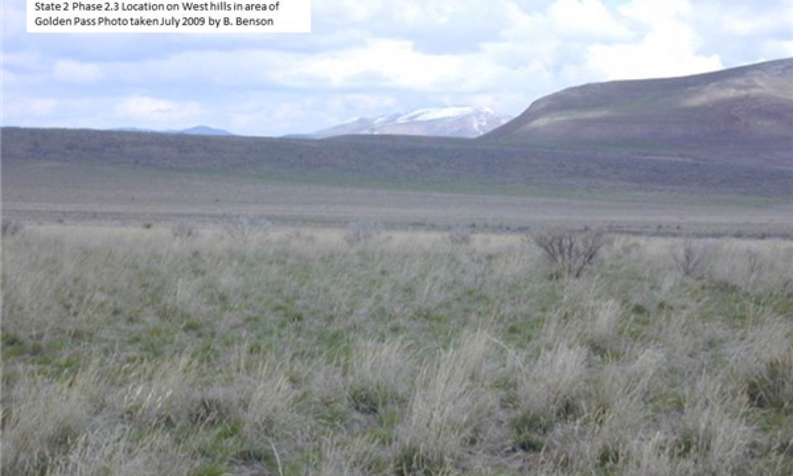
Community 2.3
Perennial Cool Season Grasses ≥ Forbs ≥ Fire Tolerant Shrubs ≥ Non-Native Species
Figure 6. R028AY309UT State 2 phase 2.3 Bluebunch wheatgrass
This community occurs when a fire moves through the site eliminating the Wyoming big sagebrush and other shrubs. The community composition is 75 percent grasses, 10 percent forbs, and 15 percent fire tolerant shrubs. This community will have 15 to 25 percent bare ground. This community will have notable amounts of non-native species.
Pathway 2.1a
Community 2.1 to 2.2Time without catastrophic event. This was probably dependent on a specific chain of climatic events.
Pathway 2.1b
Community 2.1 to 2.3Fire, insects, prolonged drought, and/or pathogens that kills and/or reduces the dominant shrub overstory. Also overgrazing with or without drought over a prolonged period of time fire and/or overgrazing are the most common of these disturbances.
Pathway 2.2a
Community 2.2 to 2.3Fire, insects, prolonged drought, and/or pathogens that kills and/or reduces the dominant shrub overstory. Also overgrazing with or without drought over a prolonged period of time fire and/or overgrazing are the most common of these disturbances
Pathway 2.3a
Community 2.3 to 2.1Time without catastrophic event. This was probably dependent on a specific chain of climatic events.
State 3
Utah Juniper Invasion StateThe Utah Juniper Invasion State has only two described plant communities, but many variations of the represented ones are present. This state occurs when lack of disturbance, typically fire, has allowed Utah juniper and pinyon to establish and increase on the site. The Utah juniper increases and uses more resources. The juniper will eventually suppresses the shrub and grass understory. Shrubs are typically the first plants to decrease and may be found in small amounts or be absent in the community. The transition to tree dominated increases the probability of non-native annual dominance in the understory as those annual species can utilize the bare space between trees. This state may also accelerate soil erosion as the understory decreases leaving more bare ground susceptible to erosion. This state is persistent until the right conditions occur for a large wildfire. Mechanical tree removal may also occur to reduce tree cover.
Characteristics and indicators. This state will have a noticeable presence of Utah juniper in the plant community.
Community 3.1
Utah juniper Wyoming big sagebrush Native Grasses & Forbs Non-Native Invasive Annuals
Figure 7. R028AY309UT State 3 Phase 3.1 Juniper Invasion
This community has a strong overstory of Utah juniper with some One-seed pinyon but still has an
understory similar to community 2.1. The community will have around 20 to 35% bare ground. Fire could potentially reset the community back to the Current Potential State.Community 3.2
Utah Juniper Invasive AnnualsThis community is present when around 95% of the native plants have been removed from the plant community and only pinyon and juniper with a sparse understory of invasive annuals are left on the site. This community will have around 45 to 85% bare ground. If any native plants are found in the community it will be very few Sandberg bluegrass.
Pathway 3.1a
Community 3.1 to 3.2Overgrazing with or without drought over a prolonged period of time.
Pathway 3.2a
Community 3.2 to 3.1Fire; insects; prolonged drought; pathogens that reduce the dominant shrub overstory. Fire is the most effective of these disturbances.
State 4
Yellow rabbitbrush/invasive annuals = native perennialsThe Yellow rabbitbrush/invasive annuals = native perennials state occurs when fire removes the non-fire tolerant shrubs like big sagebrush. Overgrazing can and often does enhance the effect of fire. Other things like drought can also lead toward this condition. The dominant visual aspect of this community are annual grasses (mainly cheatgrass brome) and yellow rabbitbrush. The plant community composition is 35 percent cheatgrass brome, 10 percent forbs, and 45 percent fire tolerant shrubs with 90 percent of the shrub component being yellow rabbitbrush with 10 percent native perennials. If the site continues along the above described path it will deteriorate to an annual plant community.
Characteristics and indicators. This state is dominated by shrubs other than Wyoming big sagebrush, such as rabbitbrush and broom snakeweed.
Community 4.1
Yellow rabbitbrush ≥ Invasive Annuals = Native perennialsThis plant community consists of about 40 percent non-native annual grass, 40 percent yellow rabbitbrush, 8 percent other fire tolerant shrubs, 10 percent forbs, and 2 percent native perennials. A continued short fire cycle (8 to 10 years) allows this community to persist. This community has about 20 to 35 percent bare ground.
Community 4.2
Invasive AnnualsThe community composition is 85 percent invasive annals, 5 percent forbs, and 5 percent native perennials with few shrubs. This community will have 25 to 40 percent bare ground.
Pathway 4.1a
Community 4.1 to 4.2Increased fire frequency (3 to 5 years) and intensity without follow-up management. Overgrazing can create conditions that enhance this pathway.
Pathway 4.2a
Community 4.2 to 4.1Time and management of grazing alone or along with other disturbances where human and/or naturalized introduction of native and/or introduced perennial plant species takes place.
State 5
Invasive Annual Grass StateThe Invasive Annual Grass State occurs when this site is overgrazed and then burned and not seeded or has a failed seeding. The dominant aspect of the plant community is cheatgrass brome and yellow rabbitbrush. The community will usually be made up of 75 percent non-native annual grasses, 10 percent forbs (introduced or native), and 10 percent yellow rabbitbrush with minor components of other shrubs. The fire frequency in this state is 4 to 8 years.
Characteristics and indicators. This state will be dominated by invasive annual plants.
Community 5.1
Invasive Annuals = Native Perennial Grasses & Forbs ≥ Few Fire Tolerant ShrubsThis plant community consists of approximately 43 percent non-native annual grasses, 32 percent native perennials, 10 percent forbs (both native and introduced), 8 percent yellow rabbitbrush, 2 percent other fire tolerant shrubs, and 5 percent other annual grasses. A continued short fire cycle (8 – 10 years) is what is needed to make this community continue along this path. This community will have around 20 to 35 percent bare ground.
Community 5.2
Invasive Annuals
Figure 8. R028AY309UT State 5 Phase 5.2 Cheatgrass brome
This plant community consists of approximately 85 percent invasive annuals (predominately cheatgrass brome), 5 percent forbs, 5 percent native perennials, and a small component of other species. This community will have around 25 to 40 percent bare ground.
Pathway 5.1a
Community 5.1 to 5.2Overgrazing and/or other types of disturbances that cause destruction of the perennial plants over a long period of time.
Pathway 5.2a
Community 5.2 to 5.1Time without disturbance and/or improved management of grazing coupled with climatic events that allow native plants to establish on the site.
State 6
Seeded Range StateThe Seeded Range State exists when the site is cultivated and/or burned and planted to introduced and/or in some situations native grasses with or with-out forbs and shrubs.
Characteristics and indicators. Non-native bunchgrasses and forbs dominate the plant community.
Community 6.1
Introduced Perennial PlantsThe plant community consists of introduced grasses and may include introduced forbs and/or shrubs. In some situations native grasses and native forbs and/or native shrubs. Or the community could be a combination of both introduced and native plants. These plantings are often as productive as the site in the Current Potential State.
Community 6.2
Native Shrubs = Introduced Perennial PlantsThis plant community occurs when management and weather conditions create the kind of episodic situation that allows Wyoming big sagebrush and other native plant species to move back onto the site.
Pathway 6.1a
Community 6.1 to 6.2Time without catastrophic event. This was probably dependent on a specific chain of climatic events.
Pathway 6.2a
Community 6.2 to 6.1Time and management of grazing alone or along with other disturbances where human intervention takes place to move the community back.
Transition T1a
State 1 to 2Introduction of non-native species into the ecosystem.
Transition T1b
State 1 to 3Introduction of Utah juniper along with the introduction of non-native species into the ecosystem. Along with prolonged drought, overgrazing, extreme lengthening of the fire interval frequency. This takes place when the sagebrush canopy increases and destroys the perennial grass and forb under story and the fire frequency is increased from 50 to 60 years to 70 to 90 years and the introduction of Utah juniper with pinyon in areas where seed for these species are available.
Transition T2a
State 2 to 3Prolonged drought, overgrazing, extreme lengthening of the fire interval frequency. This takes place when the sagebrush canopy gets so heavy that it destroys the perennial grass and forb under story and the fire frequency is increased from 50 to 60 years to 70 to 90 years and the introduction of Utah juniper with pinyon in areas where the seed for these species are available.
Transition T2b
State 2 to 4Overgrazing and/or increase of fire frequency over a long period, between 8 and 12 years between fires.
Transition T2c
State 2 to 5Overgrazing and/or increase of fire frequency over a long period, between 4 and 8 years between fires.
Transition T2d
State 2 to 6Human caused disturbance (mechanical treatment and seeding; chemical treatment and seeding. etc.)
Transition T3a
State 3 to 4Continued overgrazing and increase of fire frequency over a very prolonged period. (8 to 12 year fire frequency interval)
Transition T3b
State 3 to 6Human caused disturbance (mechanical treatment and seeding; chemical treatment and seeding. etc.)
Transition T4a
State 4 to 5Time without catastrophic event and/or with management of grazing and often energy inputs. The community phase 4.2 will be self-sustaining if the fire frequency remains 3 to 5 years. This will continue unless a large amount of energy is injected into the system and management is changed..
Transition T4b
State 4 to 6Human caused disturbance (mechanical treatment and seeding; chemical treatment and seeding. etc.)
Transition T5a
State 5 to 6Human caused disturbance (mechanical treatment and seeding; chemical treatment and seeding etc.)
Restoration pathway R6a
State 6 to 2Time with proper management that favors the native plants as they establish on site. This may take over 30 years. The time frame depends on management and on the precipitation amounts.
Conservation practices
Prescribed Grazing Grazing Management Plan - Applied Additional community tables
Table 7. Community 1.1 plant community composition
Group Common name Symbol Scientific name Annual production () Foliar cover (%) Shrub/Vine0 Primary Shrubs 180–300 Grass, perennial 2GP Grass, perennial 48–120 – Grass, annual 2GA Grass, annual 36–60 – slender wheatgrass ELTR7 Elymus trachycaulus 12–60 – Idaho fescue FEID Festuca idahoensis 12–36 – needle and thread HECO26 Hesperostipa comata 12–36 – prairie Junegrass KOMA Koeleria macrantha 12–36 – western wheatgrass PASM Pascopyrum smithii 12–36 – Sandberg bluegrass POSE Poa secunda 12–36 – thickspike wheatgrass ELLA3 Elymus lanceolatus 12–36 – purple threeawn ARPU9 Aristida purpurea 12–24 – sand dropseed SPCR Sporobolus cryptandrus 12–24 – 3 Secondary Shrubs 120–360 Grass/Grasslike0 PrimaryGrasses 540–780 Forb, annual 2FA Forb, annual 60–120 – Forb, perennial 2FP Forb, perennial 60–120 – common yarrow ACMI2 Achillea millefolium 12–36 – white sagebrush ARLU Artemisia ludoviciana 12–36 – freckled milkvetch ASLE8 Astragalus lentiginosus 12–36 – woolly locoweed ASMO7 Astragalus mollissimus 12–36 – matted buckwheat ERCA8 Eriogonum caespitosum 12–36 – Eaton's fleabane EREA Erigeron eatonii 12–36 – shaggy fleabane ERPU2 Erigeron pumilus 12–36 – common sunflower HEAN3 Helianthus annuus 12–36 – prairie flax LILEA Linum lewisii var. alpicola 12–36 – western stoneseed LIRU4 Lithospermum ruderale 12–36 – tailcup lupine LUCAC3 Lupinus caudatus ssp. caudatus 12–36 – whitestem blazingstar MEAL6 Mentzelia albicaulis 12–36 – tapertip hawksbeard CRAC2 Crepis acuminata 12–36 – roundspike cryptantha CRHU2 Cryptantha humilis 12–36 – low beardtongue PEHU Penstemon humilis 12–36 – gooseberryleaf globemallow SPGR2 Sphaeralcea grossulariifolia 12–36 – foothill deathcamas ZIPA2 Zigadenus paniculatus 12–24 – longleaf phlox PHLO2 Phlox longifolia 12–24 – longstalk springparsley CYLO Cymopterus longipes 12–24 – tall annual willowherb EPBR3 Epilobium brachycarpum 12–24 – Brandegee's woollystar ERBR3 Eriastrum brandegeeae 12–24 – yellow owl's-clover ORLU2 Orthocarpus luteus 12–24 – sego lily CANU3 Calochortus nuttallii 12–24 – wavyleaf thistle CIUNU Cirsium undulatum var. undulatum 12–24 – 1 Secondary Grasses 120–240 Forb0 Primary Forbs 60–180 Shrub, other 2S Shrub, other 60–120 – yellow rabbitbrush CHVI8 Chrysothamnus viscidiflorus 12–36 – Nevada jointfir EPNE Ephedra nevadensis 12–36 – slender buckwheat ERMI4 Eriogonum microthecum 12–36 – plains pricklypear OPPO Opuntia polyacantha 12–36 – spineless horsebrush TECA2 Tetradymia canescens 12–36 – broom snakeweed GUSA2 Gutierrezia sarothrae 0–24 – 2 Secondary Forbs 240–480 Table 8. Community 1.2 plant community composition
Group Common name Symbol Scientific name Annual production () Foliar cover (%) Table 9. Community 1.3 plant community composition
Group Common name Symbol Scientific name Annual production () Foliar cover (%) Table 10. Community 2.1 plant community composition
Group Common name Symbol Scientific name Annual production () Foliar cover (%) Table 11. Community 2.2 plant community composition
Group Common name Symbol Scientific name Annual production () Foliar cover (%) Table 12. Community 2.3 plant community composition
Group Common name Symbol Scientific name Annual production () Foliar cover (%) Table 13. Community 3.1 plant community composition
Group Common name Symbol Scientific name Annual production () Foliar cover (%) Table 14. Community 3.2 plant community composition
Group Common name Symbol Scientific name Annual production () Foliar cover (%) Table 15. Community 4.1 plant community composition
Group Common name Symbol Scientific name Annual production () Foliar cover (%) Table 16. Community 4.2 plant community composition
Group Common name Symbol Scientific name Annual production () Foliar cover (%) Table 17. Community 5.1 plant community composition
Group Common name Symbol Scientific name Annual production () Foliar cover (%) Table 18. Community 5.2 plant community composition
Group Common name Symbol Scientific name Annual production () Foliar cover (%) Table 19. Community 6.1 plant community composition
Group Common name Symbol Scientific name Annual production () Foliar cover (%) Table 20. Community 6.2 plant community composition
Group Common name Symbol Scientific name Annual production () Foliar cover (%) Interpretations
Animal community
The Upland Loam (Wyoming Big Sagebrush) site provides both food and cover for wildlife.
This site is a part of the sagebrush steppe and supports many at-risk neotropical migratory bird species and may support pygmy rabbit (Brachylagus idahoensis). Other wildlife using this site include black-tail jackrabbit; gold eagle; ravens and mule deer. This is a short list of the more common species found. Many other species are present as well.
This site is suited for grazing by cattle and sheep during spring, summer, and fall.Hydrological functions
The soil series are in Hydologic group B. The runoff curve number is 61 when the vegetation and soils are in good condition.
Recreational uses
Resources that have special aesthetic and landscape values are grassland aesthetics. Some recreation uses of this site are camping, hiking, and hunting.
Wood products
No wood products, except in the Utah Juniper Invasion State, where fire wood and cedar posts would be available.
Supporting information
Inventory data references
The Range site description was documented with 20 NRCS-ECS-417s and 10 UT-Range 2s.
Other references
Anderson, E. W. and R. J. Scherzinger. 1975. Improving quality of winter forage for elk by cattle grazing. Journal of Range Management:120-125.
Blaisdell, J.P. and J.F. Pechanec. 1949. Effects of herbage removal at various dates on vigor of bluebunch wheatgrass and arrowleaf balsamroot. Ecology 30(3):298-305.
Daubenmire, R. 1970. Steppe Vegetation of Washington. 131 pp.
Laycock, W. A. 1967. How heavy grazing and protection affect sagebrush-grass ranges. Journal of Range Management:206-213.
Lett, M. S., and A. K. Knapp. 2005. Woody plant encroachment and removal in mesic grassland: Production and composition responses of herbaceous vegetation. American Midland Naturalist 153:217-231.
Miller, R.F., J.C. Chambers, D.A. Pyke, F.B. Pierson, and C.J. Williams. 2013. A review of fire effects on vegetation and soils in the Great Basin Region: response and ecological site characteristics. Gen. Tech. Rep. RMRS-GTR-308. Fort Collins, CO: U.S. Department of Agriculture, Forest Service, Rocky Mountain Research Station. 126 p.
Miller, R.F., J.C. Chambers, and M. Pellant. 2015. A field guide for rapid assessment of post-wildfire recovery potential in sagebrush and pinon-juniper ecosystems in the Great Basin: Evaluating resilience to disturbance and resistance to invasive annual grasses and predicting vegetation response. Gen. Tech. Rep. RMRS-GTR-338. Fort Collins, CO: U.S. Department of Agriculture, Forest Service, Rocky Mountain Research Station. 70 p.
Miller, R. F., T. J. Svejcar, and J. A. Rose. 2000. Impacts of western juniper on plant community composition and structure. Journal of Range Management:574-585.
Pierson, F. B., C. J. Williams, P. R. Kormos, S. P. Hardegree, P. E. Clark, and B. M. Rau. 2010. Hydrologic vulnerability of sagebrush steppe following pinyon and juniper encroachment. Rangeland Ecology & Management 63:614-629.
Tisdale, E. W. and M. Hironaka. 1981. The sagebrush-grass region: A review of the ecological literature. University of Idaho, Forest, Wildlife and Range Experiment Station.Contributors
Brock Benson
Approval
Marji Patz, 6/12/2025
Rangeland health reference sheet
Interpreting Indicators of Rangeland Health is a qualitative assessment protocol used to determine ecosystem condition based on benchmark characteristics described in the Reference Sheet. A suite of 17 (or more) indicators are typically considered in an assessment. The ecological site(s) representative of an assessment location must be known prior to applying the protocol and must be verified based on soils and climate. Current plant community cannot be used to identify the ecological site.
Author(s)/participant(s) Brock Benson (NRCS), Shane Green (NRCS) Contact for lead author Shane Green (NRCS) shane.green@ut.usda.gov Date 04/25/2014 Approved by Approval date Composition (Indicators 10 and 12) based on Annual Production Indicators
-
Number and extent of rills:
None to few. Any rills present should be short in length (less than 1.5 feet long) and follow the surface micro-features. Old rills will weather quickly because of loamy surface textures. A slight increase in rill formation may be caused by major disturbance events such as severe thunderstorms. -
Presence of water flow patterns:
Flow patterns around perennial plants bases will show minor evidence of erosion. They will be short (1 to 3 feet long) and look stable. There is slight evidence of deposition. -
Number and height of erosional pedestals or terracettes:
Plants should show slight (1/8 – ½ in.) pedestialing. Pedestialing on the down slope side of plants may appear to be greater than this and will be more visible as slopes increase. Terracettes should be absent until slopes are greater than 20 %. At this point the terracettes should look stable and have little evidence of soil being re-deposited. -
Bare ground from Ecological Site Description or other studies (rock, litter, lichen, moss, plant canopy are not bare ground):
10 to 30 % (10 – 15 % on slopes up to 25 % and 15 – 30 % on slopes from 25 % up) -
Number of gullies and erosion associated with gullies:
None to very few. Any gullies present should show little sign of active erosion and should appear stable having perennial plants growing in the bottom and on the sides. -
Extent of wind scoured, blowouts and/or depositional areas:
Slight wind generated soil movement is normal. Wind caused blowouts are very rare and are mostly stable and have healed over or started to do so. Increased wind generated soil movement can occur after severe wind events but will not be visually apparent. -
Amount of litter movement (describe size and distance expected to travel):
Little redistribution can be caused by both wind and water. Very fine to fine litter movement may occur in water flow patterns with deposition occurring at points of obstruction. Fine litter may be removed from its original site by wind action. -
Soil surface (top few mm) resistance to erosion (stability values are averages - most sites will show a range of values):
80 to 90% of this site should have soil surfaces that are stabilized by organic matter both decompositional and incorporated. This should be observable in that water flow patterns are not scoured to where the surface is visibly smoother than soil surfaces in non flow pattern areas. -
Soil surface structure and SOM content (include type of structure and A-horizon color and thickness):
The A horizon is varies from 5 to 16 inches thick. Color is a grayish brown gravelly loam (typical mollic colors). Structure should be granular. -
Effect of community phase composition (relative proportion of different functional groups) and spatial distribution on infiltration and runoff:
When perennial plant community is intact it will maintain the organic granular structure, soil porosity, and sinuous water flow paths that allows water to infiltrate at a rate that will not lend to water leaving the site. If the plant community has been degraded then the site will show longer and/or smoother than expected water flow patterns. -
Presence and thickness of compaction layer (usually none; describe soil profile features which may be mistaken for compaction on this site):
There should be no compaction layer. -
Functional/Structural Groups (list in order of descending dominance by above-ground annual-production or live foliar cover using symbols: >>, >, = to indicate much greater than, greater than, and equal to):
Dominant:
Bluebunch wheatgrass > indian ricegrass > Nevada bluegrass & Bottlebrush squirreltail >= wyoming big sagebrush > arrowleaf balsamroot.Sub-dominant:
Slender wheatgrass > western wheatgrass >= Idaho fescue andother perennial grasses >= western yarrow and other perennial forbs >= other shrubs.Other:
There is a wide variety of other Grasses, forbs and shrubs besides the ones noted above.Additional:
This community requires fire to properly maintain itself. Assume a fire cycle of 45 to 60 years -
Amount of plant mortality and decadence (include which functional groups are expected to show mortality or decadence):
All age classes (seedling, immature, mature, and decadent) of perennial bunchgrasses and non-sprouting shrubs should be present. The % of decadent and/or dead plants should not exceed 5 %. -
Average percent litter cover (%) and depth ( in):
Litter cover will be notebly heavier under plants. Most litter will be herbaceous. Perennial vedegation should be well distributed on the site. -
Expected annual annual-production (this is TOTAL above-ground annual-production, not just forage annual-production):
1150 to 1200 lb./acre on slopes less than 20 % and 100 to 1100 lb./acre on slopes 20 to 30 % under normal growing conditions. -
Potential invasive (including noxious) species (native and non-native). List species which BOTH characterize degraded states and have the potential to become a dominant or co-dominant species on the ecological site if their future establishment and growth is not actively controlled by management interventions. Species that become dominant for only one to several years (e.g., short-term response to drought or wildfire) are not invasive plants. Note that unlike other indicators, we are describing what is NOT expected in the reference state for the ecological site:
As ecological condition deteriorates due to outside disturbances, perennial bunch grasses decrease while less desirable plants like Low rabbitbrush, and Pricklypear increase along with invasive plants like Cheatgrass brome and Utah juniper. When the historic climax plant community is burned, wyoming big sagebrush will decrease while perennial grasses, forbs and yellow rabbitbrush increase markedly. Broom snakeweed and nevada jointfir increase to a much lesser extent. If the site is burned too frequently cheatgrass brome, halogeton, broom snakeweed and russian thistle are most likely to invade this site and eventually dominate it. -
Perennial plant reproductive capability:
All plants should have the ability to reproduce either by seed and/or vegetative tillers in all years, except after prolonged extreme drought years.
Print Options
Sections
Font
AAAAOther
PrintThe Ecosystem Dynamics Interpretive Tool is an information system framework developed by the USDA-ARS Jornada Experimental Range, USDA Natural Resources Conservation Service, and New Mexico State University.
Accessibility statement


