
Natural Resources
Conservation Service
-
Search


Major Land Resource Area or ecological site by name and/or ID.
PreviousSectionsNextGeneral information
Draft. A draft ecological site description is either incomplete or has not undergone quality control and quality assurance review.
MLRA notes
Major Land Resource Area (MLRA): 022A–Sierra Nevada and Tehachapi Mountains
MLRA 22A
Major Land Resource Area 22A, Sierra Nevada Mountains, is located predominantly in California and a small section of western Nevada. The area lies completely within the Sierra Nevada Section of the Cascade-Sierra Mountains Province. The Sierra Nevada range has s gentle western slope, and a very abrupt eastern slope. The Sierra Nevada consists of hilly to steep mountains and occasional flatter mountain valleys. Elevation ranges between 1,500 and 9,000 ft throughout most of the range, but peaks often exceed 12,000 ft. The highest point in the continental US occurs in this MLRA (Mount Whitney, 14,494 ft). Most of the Sierra Nevada is dominated by granitic rock of the Mesozoic age, known as the Sierra Nevada Batholith. The northern half is flanked on the west by a metamorphic belt, which consists of highly metamorphosed sedimentary and volcanic rocks. Additionally, glacial activity of the Pleistocene has played a major role in shaping Sierra Nevada features, including cirques, arêtes, and glacial deposits and moraines. Average annual precipitation ranges from 20 to 80 inches in most of the area, with increases along elevational and south-north gradients. Soil temperature regime ranges from mesic, frigid, and cryic. Due to the extreme elevational range found within this MLRA, Land Resource Units (LRUs) were designated to group the MLRA into similar land units.
LRU "C" Northern Sierra Subalpine: Elevations are typically between 7,800 and 9,800 feet. The frost free period is between 30 and 90 days, MAAT is between 35 and 44 degrees, MAP is between 45 and 65 inches. Soils are typically cryic, but frigid soils may occur at lower elevations on southern aspects. Forests are dominated by whitebark pine (Pinus albicaulis), Sierra lodgepole pine (Pinus contorta spp. murrayana), mountain hemlock (Tsuga mertensiana) and/or California red fir (Abies magnifica).
Ecological site concept
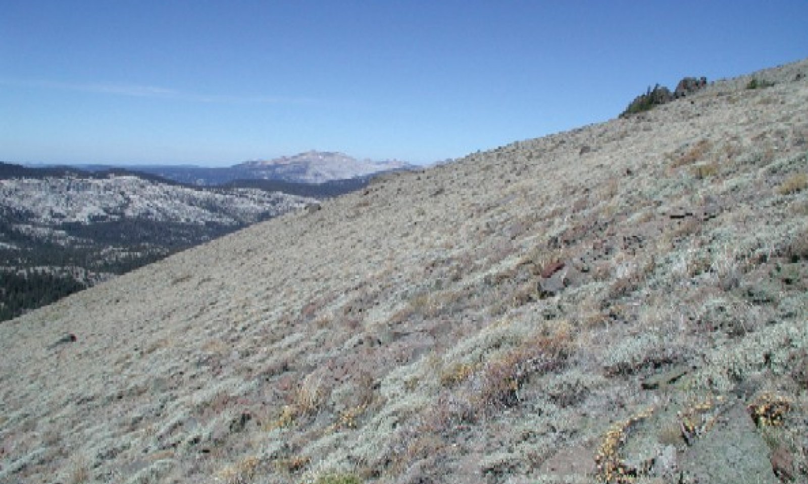
This ecological site occurs on high rocky montane slopes with shallow umbric soils and a typic xeric soil moisture regime and cryic soil temperature regime. Elevations are typically between 8,000 and 9,000 feet and slopes typically between 15 and 50 percent. Shallow soils support a dwarf shrub community dominated by low sagebrush (Artemisia arbuscula). Low sagebrush dominates where soils are too dry or shallow for mountain big sagebrush (Artemisia tridentata ssp. vaseyana). It is associated with cold exposed sites with shallow soils. Annual production is relatively low, with a reference value of 475 pounds per acre, and ranging from 330 to 620 pounds per acre.
Tabular data ranges for the following Physiographic, Climate, and Soils sections are based on major (15% or greater) components only.Associated sites
F022AY103NV POTR5/SYMPH/BRMA4
Occurs on adjacent mountain slopes. Aspen (Populus tremuloides) dominates.
R022AC200CA High Elevation Volcanic Mountain Slopes
Occurs on adjacent higher elevation slopes with moderately deep soils. This site occurs near treeline and is dominated by whitebark pine (Pinus albicaulis).
R022AC204CA Cryic, Umbric Or Andic Slopes
Occurs on adjacent mountain slopes with more productive soils and topographic positions. Mountain big sagebrush (Artemisia tridentata ssp. vaseyana) and antelope bitterbrush (Purshia tridentata) dominate with a productive herbaceous community.
Similar sites
R022AC204CA Cryic, Umbric Or Andic Slopes
This site is found on more productive soils and topographic positions. Mountain big sagebrush (Artemisia tridenata ssp. vaseyana) and antelope bitterbrush (Purshia tridentata) dominate while low sagebrush (Artemisia arbuscula) is a minor species if present.
Table 1. Dominant plant species
Tree Not specified
Shrub (1) Artemisia arbuscula
(2) Eriogonum umbellatumHerbaceous (1) Poa secunda
(2) Phlox diffusaPhysiographic features
This ecological site is found on mountainous uplands, between 8,000 and 10,000 feet in elevation, but typically below 9,000 feet. It occurs on all aspects, but typically occurs on northeast to northwest facing slopes. Slopes range from 15 to 75 percent, but are typically below 50 percent. Runoff is very high.
Table 2. Representative physiographic features
Landforms (1) Mountain
Flooding frequency None Ponding frequency None Elevation 8000 – 10000 ft Slope 15 – 75 % Aspect N, NE, NW Climatic features
The climate of this ecological site is characterized by cool temperatures, wet winters with most precipitation falling as snow in winters, and relatively dry summers. The mean annual precipitation ranges from 40 to 50 inches and mean annual air temperature ranges from 36 to 39 degrees F. The frost free period is 30 to 60 days, and the freeze free period is 40 to 80 days.
Maximum and minimum monthly climate data for this ESD were generated by the Climate Summarizer
(http://www.nm.nrcs.usda.gov/technical/handbooks/nrph/Climate_Summarizer.xls). The data from multiple weather stations were combined to most accurately reflect the climatic conditions of this ecological site. These weather stations occur at the lower elevation range of this ecological site.
Table 3 Representative climatic features
Frost-free period (average) 60 days Freeze-free period (average) 50 days Precipitation total (average) 50 in BarLineFigure 1. Monthly precipitation range
BarLineFigure 2. Monthly average minimum and maximum temperature
Figure 3. Annual precipitation pattern
Figure 4 Annual average temperature pattern
">Influencing water features
This ecological site is not influenced by wetland or riparian water features.
Soil features
The soils associated with this site are very shallow to shallow to hard volcanic bedrock. Soils are derived from colluvium over residuum from andesite, andesitic lahar, and tuff brecciea. Soils are somewhat excessively to excessively drained and have moderately rapid permeability. The soil moisture regime is xeric and the soil temperature regime is cryic. Surface textures are cobbly ashy loam and extremely gravelly sandy loam. Subsurface textures are gravelly ashy loam and very and extremely gravelly sandy loam. Surface rock fragments smaller than 3 inches in diameter range from 20 to 60 percent, and larger rock fragments range from 1 to 10 percent. Subsurface rock fragments less than 3 inches in diameter range from 20 to 66 percent by volume and larger rock fragments range from 0 to 10 percent for a depth of 13 inches. The soils correlated with this site are Meiss (Loamy, isotic Lithic Humicryepts), and Lithnip (Loamy-skeletal, isotic, nonacid Lithic Cryorthents). Meiss soils have an umbric epipedon from 0 to 3 inches.
This ecological site has been correlated with the following mapunits and soil components in the Tahoe Basin soil survey area (CA693):
Area_sym ; Musym ; MUname ; Compname ; Local_phase ; Comp_pct
CA693 ; 9131 ; Lithnip-Meiss-Hawkinspeak association, 30 to 75 percent slopes ; Lithnip ; ; 40; Meiss ; ; 30
CA693 ; 9171 ; Mountrose-Wardcreek-Melody complex, 50 to 70 percent slopes ; Meiss ; ; 5
CA693 ; 7191 ; Rock outcrop, volcanic ; Lithnip ; ; 2; Meiss ; ; 2
CA693 ; 9111 ; Florand-Lostridge-Fishsnooze association, 15 to 50 percent slopes ; Lithnip ; ; 2
CA693 ; 9141 ; Melody-Rock Outcrop complex, 9 to 30 percent slopes ; Lithnip ; ; 1; Meiss ; ; 1
CA693 ; 9142 ; Melody-Rock Outcrop complex, 30 to 50 percent slopes ; Lithnip ; ; 1; Meiss ; ; 1
CA693 ; 9143 ; Melody-Rock outcrop complex, 50 to 70 percent slopes ; Lithnip ; ; 1; Meiss ; ; 1
CA693 ; 9161 ; Sky gravelly sandy loam, 9 to 30 percent slopes ; Lithnip ; ; 1; Meiss ; ; 1
CA693 ; 9162 ; Sky gravelly sandy loam, 30 to 50 percent slopes ; Lithnip ; ; 1; Meiss ; ; 1
CA693 ; 9163 ; Sky gravelly sandy loam, 50 to 70 percent slopes ; Lithnip ; ; 1; Meiss ; ; 1
CA693 ; 9164 ; Sky-Melody complex, 9 to 30 percent slopes ; Lithnip ; ; 1; Meiss ; ; 1
CA693 ; 9165 ; Sky-Melody complex, 30 to 50 percent slopes ; Lithnip ; ; 1; Meiss ; ; 1
CA693 ; 9166 ; Sky-Melody Complex, 50 To 70 Percent Slopes ; Lithnip ; ; 1; Meiss ; ; 1
Table 4. Representative soil features
Parent material (1) Colluvium – andesite
(2) Residuum – tuff breccia
Surface texture (1) Gravelly loam
(2) Extremely gravelly sandy loam
Family particle size (1) Loamy
Drainage class Somewhat excessively drained to excessively drained Permeability class Moderately rapid Soil depth 4 – 20 in Surface fragment cover <=3" 20 – 60 % Surface fragment cover >3" 1 – 10 % Available water capacity
(0-40in)0.2 – 1.9 in Soil reaction (1:1 water)
(0-40in)5 – 7.3 Subsurface fragment volume <=3"
(Depth not specified)20 – 66 % Subsurface fragment volume >3"
(Depth not specified)0 – 10 % Ecological dynamics
Abiotic factors
This ecological site occurs on rocky montane slopes with shallow umbric soils with a typic xeric soil moisture regime and a cryic soil temperature regime. Shallow soils support a dwarf shrub community dominated by low sagebrush. Low sagebrush dominates where soils are too dry or shallow for mountain big sagebrush (Artemisia tridentata ssp. vaseyana), and is associated with cold exposed sites where soils are shallow to bedrock or a claypan, or are fine-textured (West et al. 1978, Jensen et al. 1989, Miller and Heyerdahl 2008, Sawyer et al. 2009).
Disturbance dynamics
Infrequent fire is the dominant natural disturbance in this ecological site. Lighting ignited fires are common in the range of the site, but high cover of rock and bare ground, and low fuel levels in the reference state mean that fire does not often spread far, and the natural fire return interval is estimated to be on the order of 100 years (Blaisdell et al. 1982, Miller and Rose 1999). Fire is most likely to spread in years of high precipitation, when grasses and other forbs have high production. In the event of a fire, low sagebrush is killed, and recolonizes from seed from off-site dispersal. Reports of the time necessary for low sagebrush recovery are variable, ranging from 5 to 30 years (Steinberg 2002). The post-fire community is initially dominated by grasses and forbs (1-2 years), with resprouting shrubs increasing in abundance over time, and low sagebrush slowly regaining dominance.
Medusahead (Taeniatherum caput-medusae) invasion is a problem in lower elevation low sagebrush communities, where it may increase flammability and increase fire return frequencies (Young and Evans 1971). It has not been observed in the high elevations of this ecological site, but may become a problem with global warming.
Livestock grazing has impacted the ecological dynamics of this ecological site. Low sagebrush can tolerate light to moderate grazing, and may increase with grazing as perennial grasses decline, but may decline with severe overgrazing (Steinberg 2002). The herbaceous component of the reference community declines with grazing (Zamora and Tueller 1973), and overgrazing will cause a transition to an overgrazed state lacking perennial grasses. Severe overgrazing, or grazing combined with drought and/or fire on the shallow soils of this site can cause a transition to an eroded state.
State and transition model
Custom diagramStandard diagram
Figure 5. R022AC202CA
More interactive model formats are also available. View Interactive Models
More interactive model formats are also available. View Interactive Models
Click on state and transition labels to scroll to the respective textEcosystem states
State 1 submodel, plant communities
State 2 submodel, plant communities
State 3 submodel, plant communities
State 1
Reference StateThe reference state is maintained by long fire return intervals (approximately 100 years), and a lack of overgrazing.
Community 1.1
Reference Community Phase - Low Sagebrush
Figure 6. Reference Community Phase
Dwarf shrubs dominate this harsh landscape. Low sagebrush is dominant and sulphur-flower buckwheat (Eriogonum umbellatum) is an important secondary shrub. Other secondary shrubs may include mountain big sagebrush, roundleaf snowberry (Symphoricarpos rotundifolia), and several species of goldenbush (Ericameria spp.). Perennial forbs contribute approximately 20 percent of annual production, and common species include spreading phlox (Phlox diffusa), granite prickly phlox (Linanthus pungens), lupines (Lupinus spp.), woolly mules-ears (Wyethia mollis), and elkweed (Frasera speciosa). Perennial grasses account for approximately 10 percent of annual production. Sandberg bluegrass (Poa secunda) is the dominant grass, and squirreltail (Elymus elymoides), and needlegrass species (Achnatherum spp.) may also be present.
Moderate grazing may cause increased shrub dominance, with a decline in perennial grasses. Less palatable forbs such as woolly mule-ears may increase in abundance. Bare ground increases with grazing in this plant community, and the risk of erosion increases.
Figure 7. Annual production by plant type (representative values) or group (midpoint values)
Table 5. Annual production by plant type
Plant type Low
(lb/acre)Representative value
(lb/acre)High
(lb/acre)Shrub/Vine 230 330 430 Forb 70 100 130 Grass/Grasslike 30 45 60 Total 330 475 620 Table 6. Ground cover
Tree foliar cover 0% Shrub/vine/liana foliar cover 10-30% Grass/grasslike foliar cover 0-10% Forb foliar cover 10-20% Non-vascular plants 0-10% Biological crusts 0% Litter 20-40% Surface fragments >0.25" and <=3" 30-50% Surface fragments >3" 10-30% Bedrock 0% Water 0% Bare ground 20-30% Table 7. Canopy structure (% cover)
Height Above Ground (ft) Tree Shrub/Vine Grass/
GrasslikeForb <0.5 – 5-15% 1-10% 1-10% >0.5 <= 1 – 2-8% 0-1% 1-10% >1 <= 2 – 1-8% – – >2 <= 4.5 – – – – >4.5 <= 13 – – – – >13 <= 40 – – – – >40 <= 80 – – – – >80 <= 120 – – – – >120 – – – – Community 1.2
Fire Regeneration (Provisional)In the unlikely event of a fire, perennial grasses such as western needlegrass, squirreltail, and Sandberg bluegrass, and perennial forbs such as woolly mule-ears would be most likely to recover first. Woolly mule-ears can greatly increase after fire, sometimes becoming dominant (Parker and Yoder-Williams 1989, Riegel et al. 2002). These perennial species can withstand moderate fires, allowing the underground root crown to survive and resprout.
Grazing in the recently burned phase may slow recovery of vegetation, putting the community at risk for transitioning to an altered state, especially if accompanied by drought.
Community 1.3
Mid-Seral (Provisional)The perennial grasses and forbs continue to maintain their presence, while secondary shrubs capable of resprouting, such as sulphur-flower buckwheat, roundleaf snowberry, and rabbitbrush increase in abundance. Low sagebrush will recolonizes from seed, increasing in cover over time.
Heavy grazing in this phase may slow recovery of vegetation, putting the community at risk for transitioning to an altered state.Pathway 1.1a
Community 1.1 to 1.2Occurs with fire.
Pathway 1.2a
Community 1.2 to 1.3Occurs with time and the absence of additional disturbance, including fire, grazing and severe drought.
Pathway 1.3a
Community 1.3 to 1.1Occurs with time and the absence of additional disturbance, including fire and overgrazing.
Pathway 1.3b
Community 1.3 to 1.2Occurs with fire.
State 2
Overgrazed StateThis state develops when severe overgrazing or fire in an at-risk community (burn recovery phase or moderately grazed phase) triggers an ecological threshold to be crossed where the natural ecological dynamics no longer function and cannot be restored without active intervention. The range of diversity in the herbaceous component of the vegetation community is no longer present. The perennial grass component is absent or very sparse. Total vegetation cover is low, exposing bare ground that is susceptible to erosion. This eroded soil is inhospitable for seed germination and plant recruitment, which causes a negative feedback limiting recovery of vegetation cover.
Fire is very unlikely in this state due to very low fuels and large areas of bare ground.Community 2.1
OvergazedThis community phase is characterized by strong shrub dominance, with shrubs accounting for more than 90% of annual production. Low sagebrush is strongly dominant. Perennial grasses are absent or very rare. Forbs account for an increased proportion of annual production than in the reference plant community, and unpalatable species such as woolly mule’s ears may be abundant.
Community 2.2
Grazed + BurnedPerennial forbs recover first, and dominate this phase, with woolly mule-ears abundant. There is a high cover of bare ground. With time, secondary shrubs capable of resprouting, such as sulphur-flower buckwheat, roundleaf snowberry, and rabbitbrush increase in abundance. Low sagebrush recolonizes from seed, slowly increasing in cover.
This phase is at high risk of transitioning to an eroded state with grazing and/or severe drought.
Pathway 2.1a
Community 2.1 to 2.2Occurs in the unlikely event of fire.
Pathway 2.2a
Community 2.2 to 2.1Occurs with time and the absence of additional disturbance, including fire and grazing.
State 3
Eroded StateThis state is characterized by low vegetation cover, high bare ground, and eroded soils. This eroded soil is inhospitable for seed germination and plant recruitment, which causes a negative feedback preventing recovery of vegetation cover.
Community 3.1
Eroded Community Phase
Figure 8. Community Phase 3.1
This community phase is characterized by a high proportion of bare ground and sparse vegetative cover. Annual production and species diversity is low relative to the reference plant community. Perennial grasses are generally not present. Woolly mule-ears may increase in cover, and has the potential to dominate this phase (Matthews 1993). Increased bare ground is susceptible to erosion and indicators of erosion such as rilling are present.
The community composition table presented below is a typical example of an eroded phase community; community composition could vary.Figure 9. Annual production by plant type (representative values) or group (midpoint values)
Table 8. Annual production by plant type
Plant type Low
(lb/acre)Representative value
(lb/acre)High
(lb/acre)Forb 0 15 200 Shrub/Vine 85 120 155 Grass/Grasslike 0 0 10 Total 85 135 365 Transition T1
State 1 to 2This transition occurs with ongoing overgrazing in the reference phase.
Transition T2
State 1 to 3This transition occurs when overgrazing in an at-risk community phase (burn recovery phase or seral phase) or when continued severe overgrazing of any phase triggers an ecological threshold to be crossed where the natural ecological dynamics no longer function and cannot be restored without active intervention. This trigger causing this transition may be exacerbated by severe drought.
Transition T3
State 2 to 3This transition occurs when grazing in an at-risk community phase (burn recovery phase) or when continued severe overgrazing triggers an ecological threshold to be crossed where the natural ecological dynamics no longer function and cannot be restored without active intervention. This trigger causing this transition may be exacerbated by severe drought.
Additional community tables
Table 9. Community 1.1 plant community composition
Group Common name Symbol Scientific name Annual production () Foliar cover (%) Shrub/Vine1 Shrubs 230–430 little sagebrush ARAR8 Artemisia arbuscula 120–300 8–15 rabbitbush ERBL2 Ericameria bloomeri 0–100 0–7 mountain big sagebrush ARTRV Artemisia tridentata ssp. vaseyana 0–90 0–5 roundleaf snowberry SYRO Symphoricarpos rotundifolius 0–75 0–5 rubber rabbitbrush ERNA10 Ericameria nauseosa 0–50 0–6 sulphur-flower buckwheat ERUM Eriogonum umbellatum 20–35 3–5 singlehead goldenbush ERSU13 Ericameria suffruticosa 0–5 0–1 Grass/Grasslike2 Grasses 30–60 Sandberg bluegrass POSE Poa secunda 5–35 1–10 needlegrass ACHNA Achnatherum 1–20 0–5 western needlegrass ACOC3 Achnatherum occidentale 1–10 0–5 squirreltail ELEL5 Elymus elymoides 1–5 0–1 Forb3 Forbs 70–130 granite prickly phlox LIPU11 Linanthus pungens 0–65 0–8 spreading phlox PHDI3 Phlox diffusa 5–55 2–10 silvery lupine LUAR3 Lupinus argenteus 0–50 0–3 woolly mule-ears WYMO Wyethia mollis 0–45 0–4 lupine LUPIN Lupinus 0–25 0–8 elkweed FRSP Frasera speciosa 0–20 0–4 Lewis flax LILE3 Linum lewisii 1–10 0–3 rockcress ARABI2 Arabis 0–1 0–2 milkvetch ASTRA Astragalus 0–1 0–1 beardtongue PENST Penstemon 0–1 0–1 catchfly SILEN Silene 0–1 0–1 Table 10. Community 1.2 plant community composition
Group Common name Symbol Scientific name Annual production () Foliar cover (%) Table 11. Community 1.3 plant community composition
Group Common name Symbol Scientific name Annual production () Foliar cover (%) Table 12. Community 2.1 plant community composition
Group Common name Symbol Scientific name Annual production () Foliar cover (%) Table 13. Community 2.2 plant community composition
Group Common name Symbol Scientific name Annual production () Foliar cover (%) Table 14. Community 3.1 plant community composition
Group Common name Symbol Scientific name Annual production () Foliar cover (%) Shrub/Vine1 Shrubs 85–155 little sagebrush ARAR8 Artemisia arbuscula 50–100 5–8 roundleaf snowberry SYRO Symphoricarpos rotundifolius 50–100 3–5 sulphur-flower buckwheat ERUM Eriogonum umbellatum 30–60 3–5 Forb2 Forb 0–200 woolly mule-ears WYMO Wyethia mollis 0–150 0–15 lupine LUPIN Lupinus 10–20 1–5 Lewis flax LILE3 Linum lewisii 10–20 0–2 Interpretations
Animal community
Low sagebrush provides cover and nesting sites for a range of birds (Steinberg 2002). It is considered valuable browse for mule deer, and fair winter browse for sheep and cattle (Steinberg 2000).
Recreational uses
This ecological site occurs in very scenic areas appropriate for well-designed hiking trails.
Supporting information
Inventory data references
The following NRCS plots represent this ecological site. Community Phase 1.1: MxF02h8 (Type location) MxF02h1 MxF02h2 MxF02h4 Community Phase 2.1: MxF02h11
Type locality
Location 1: El Dorado County, CA Township/Range/Section T10N R18E S10 UTM zone N UTM northing 4291466 UTM easting 240202 General legal description The site location is east of Stevens Peak, on Meiss Meadow side of the ridge. Access from Carson Pass off of HW 89. Other references
Blaisdell, J. P., R. B. Murray, and E. D. McArthur. 1982. Managing intermountain rangelands--sagebrush-grass ranges. U.S. Department of Agriculture, Forest Service, Intermountain Forest and Range Experimental Station, Ogden, UT.
Jensen, M. E., L. S. Peck, and M. V. Wilson. 1989. Soil characteristics of mountainous northeastern Nevada sagebrush community types. Western North American Naturalist 49:469-481.
Matthews, R. F. 1993. Wyethia amplexicaulis. Fire Effects Information System. U.S. Department of Agriculture, Forest Service, Rocky Mountain Research Station, Fire Sciences Laboratory.
Miller, R. F. and E. K. Heyerdahl. 2008. Fine-scale variation of historical fire regimes in sagebrush-steppe and juniper woodland: an example from California, USA. International Journal of Wildland Fire 17:245-254.
Miller, R. F. and J. A. Rose. 1999. Fire history and western juniper encroachment in sagebrush steppe. Journal of Range Management 52:550-559.
Parker, V. T. and M. P. Yoder-Williams. 1989. Reduction of survival and growth of young Pinus jeffreyi by an herbaceous perennial, Wyethia mollis. American Midland Naturalist 121:105-111.
Riegel, G. M., T. J. Svejcar, and M. D. Busse. 2002. Does the presence of Wyethia mollis affect growth of Pinus jeffreyi seedlings? Western North American Naturalist 62:141-150.
Sawyer, J. O., T. Keeler-Woolf, and J. M. Evans. 2009. A manual of California vegetation. 2nd edition. California Native Plant Society, Sacramento, California.
Steinberg, P. D. 2002. Artemisia arbuscula. Fire Effects Information System. U.S. Department of Agriculture, Forest Service, Rocky Mountain Research Station, Fire Sciences Laboratory.
West, N. E., R. J. Tausch, K. H. Rea, and P. T. Teuller. 1978. Taxonomic determination, distribution, and ecological indicator values of sagebrush within the pinyon-juniper woodlands of the Great Basin. Journal of Range Management 31:87-92.
Young, J. A. and R. A. Evans. 1971. Medusahead invasion as influenced by herbicides and grazing on low sagebrush sites. Journal of Range Management 24:451-454.
Zamora, B. and P. T. Tueller. 1973. Artemisia arbuscula, A. longiloba, and A. nova habitat types in northern Nevada. The Great Basin Naturalist 33:225-242.
Contributors
Alice Miller
Marchel M. MunneckeRangeland health reference sheet
Interpreting Indicators of Rangeland Health is a qualitative assessment protocol used to determine ecosystem condition based on benchmark characteristics described in the Reference Sheet. A suite of 17 (or more) indicators are typically considered in an assessment. The ecological site(s) representative of an assessment location must be known prior to applying the protocol and must be verified based on soils and climate. Current plant community cannot be used to identify the ecological site.
Author(s)/participant(s) Contact for lead author Date Approved by Approval date Composition (Indicators 10 and 12) based on Annual Production Indicators
-
Number and extent of rills:
-
Presence of water flow patterns:
-
Number and height of erosional pedestals or terracettes:
-
Bare ground from Ecological Site Description or other studies (rock, litter, lichen, moss, plant canopy are not bare ground):
-
Number of gullies and erosion associated with gullies:
-
Extent of wind scoured, blowouts and/or depositional areas:
-
Amount of litter movement (describe size and distance expected to travel):
-
Soil surface (top few mm) resistance to erosion (stability values are averages - most sites will show a range of values):
-
Soil surface structure and SOM content (include type of structure and A-horizon color and thickness):
-
Effect of community phase composition (relative proportion of different functional groups) and spatial distribution on infiltration and runoff:
-
Presence and thickness of compaction layer (usually none; describe soil profile features which may be mistaken for compaction on this site):
-
Functional/Structural Groups (list in order of descending dominance by above-ground annual-production or live foliar cover using symbols: >>, >, = to indicate much greater than, greater than, and equal to):
Dominant:
Sub-dominant:
Other:
Additional:
-
Amount of plant mortality and decadence (include which functional groups are expected to show mortality or decadence):
-
Average percent litter cover (%) and depth ( in):
-
Expected annual annual-production (this is TOTAL above-ground annual-production, not just forage annual-production):
-
Potential invasive (including noxious) species (native and non-native). List species which BOTH characterize degraded states and have the potential to become a dominant or co-dominant species on the ecological site if their future establishment and growth is not actively controlled by management interventions. Species that become dominant for only one to several years (e.g., short-term response to drought or wildfire) are not invasive plants. Note that unlike other indicators, we are describing what is NOT expected in the reference state for the ecological site:
-
Perennial plant reproductive capability:
Print Options
Sections
Font
AAAAOther
PrintThe Ecosystem Dynamics Interpretive Tool is an information system framework developed by the USDA-ARS Jornada Experimental Range, USDA Natural Resources Conservation Service, and New Mexico State University.
Accessibility statement


