
Natural Resources
Conservation Service
Ecological site F236XY111AK
Boreal Forest Loamy Flood Plains
Last updated: 2/07/2024
Accessed: 09/24/2026
-
Search


Major Land Resource Area or ecological site by name and/or ID.
PreviousSectionsNextGeneral information
Provisional. A provisional ecological site description has undergone quality control and quality assurance review. It contains a working state and transition model and enough information to identify the ecological site.
Click to explore map
Figure 1. Mapped extent
Areas shown in blue indicate the maximum mapped extent of this ecological site. Other ecological sites likely occur within the highlighted areas. It is also possible for this ecological site to occur outside of highlighted areas if detailed soil survey has not been completed or recently updated.
MLRA notes
Major Land Resource Area (MLRA): 236X–Bristol Bay-Northern Alaska Peninsula Lowlands
The Bristol Bay-Northern Alaska Peninsula Lowland Major Land Resource Area (MLRA 236) is located in Western Alaska. This MLRA covers approximately 19,500 square miles and is defined by an expanse of nearly level to rolling lowlands, uplands and low to moderate hills bordered by long, mountain footslopes. Major rivers include the Egegik, Mulchatna, Naknek, Nushagak, and Wood River. MLRA 236 is in the zone of discontinuous permafrost. It is primarily in areas with finer textured soils on terraces, rolling uplands and footslopes. This MLRA was glaciated during the early to middle Pleistocene. Moraine and glaciofluvial deposits cover around sixty percent of the MLRA. Alluvium and coastal deposits make up a large portion of the remaining area (Kautz et al., 2012; USDA, 2006).
Climate patterns across this MLRA shift as one moves away from the coast. A maritime climate is prominent along the coast, while continental weather, commonly associated with Interior Alaska, is more influential inland. Across the MLRA, summers are general short and warm while winters are long and cold. Mean annual precipitation is 13 to 50 inches, with increased precipitation at higher elevations and areas away from the coast. Mean annual temperatures is between 30 and 36 degrees F (USDA, 2006).
The Bristol Bay-Northern Alaska Peninsula MLRA is principally undeveloped wilderness. Federally managed land includes parts of the Katmai and Aniakchak National Parks, and the Alaska Peninsula, Becharof, Togiak and Alaska Maritime National Wildlife Refuges. The MLRA is sparsely populated. Principal communities include Dillingham, Naknek, and King Salmon. Commercial fishing in Bristol Bay and the Bering Sea comprises a major part of economic activity in the MLRA. Other land uses include subsistence activities (fishing, hunting, and gathering) and sport hunting and fishing (USDA, 2006).Ecological site concept
This boreal ecological site is on high flood plains, which are defined relative to low flood plains. High flood plains are typically further from the flood source, and flood less frequently and with less scouring energy than low flood plains. Water run-in via precipitation and snow melt are the main sources of water on this site. Site elevation ranges from sea level to 580 feet. Slopes gradients are nearly level (0 – 2 percent). Soils are predominantly well drained silt and silt loams atop sandy or gravelly parent material. Soil and site characteristics and a flooding regime shape the vegetative communities.
The reference state supports four communities. The reference community phase is a mixed forest (Viereck et al., 1992) with an open understory of bluejoint grass (Calamagrostis canadensis) and diverse forbs and shrubs. An alternative state is associated with beaver (Castor canadensis) ponds.Associated sites
F236XY150AK Boreal Forest Loamy Wet Flood Plains
Ecological site F236XY150AK (Boreal Forest Loamy Flood Plains, Wet) is on boreal high flood plains. It is subject to occasional, brief periods of ponding due to the concave positions of the site, proximity to wetland, and poorly drained soils. Ecological site F236XY111AK is not in concave areas and is subject to rare periods of ponding.
Similar sites
F236XY150AK Boreal Forest Loamy Wet Flood Plains
Ecological site F236XY150AK (Boreal Forest Loamy Flood Plains, Wet) is on boreal high flood plains. It is subject to occasional, brief periods of ponding due to the concave positions of the site, proximity to wetland, and poorly drained soils. Ecological site F236XY111AK is not in concave areas and is subject to rare periods of ponding.
Table 1. Dominant plant species
Tree (1) Picea glauca
(2) Betula papyriferaShrub (1) Rubus arcticus
(2) Viburnum eduleHerbaceous (1) Calamagrostis canadensis
(2) Dryopteris expansaPhysiographic features
This boreal ecological site is on high flood plains of lowlands. It ranges from sea level to 580 feet in elevation, and it has nearly level slopes (0 to 2 percent). Aspect does not influence the plant community dynamics of this site. Flooding is the major disturbance in this ecological site. It is a very rare to occasional event.
Table 2. Representative physiographic features
Landforms (1) Valley > Flood plain
Flooding duration Very brief (4 to 48 hours) Flooding frequency Very rare to rare Ponding frequency Rare Elevation 0 – 580 ft Slope 0 – 2 % Water table depth 1 – 4 in Aspect W, NW, N, NE, E, SE, S, SW Table 3. Representative physiographic features (actual ranges)
Flooding duration Very brief (4 to 48 hours) to brief (2 to 7 days) Flooding frequency Very rare to occasional Ponding frequency Rare to frequent Elevation 0 – 1560 ft Slope 0 – 5 % Water table depth 1 – 4 in Climatic features
The climate of this site reflects that of the MLRA, which is described as maritime polar (EPA, 2013). Temperatures are moderated by the nearby Bristol Bay and norther Pacific bodies of water. Annual precipitation ranges from 21 – 34 inches with approximately 40 percent occurring during the June-September growing season (PRISM, 2018).
Table 4 Representative climatic features
Frost-free period (characteristic range) 80-100 days Freeze-free period (characteristic range) 70-90 days Precipitation total (characteristic range) 20-30 in Frost-free period (actual range) 80-100 days Freeze-free period (actual range) 70-90 days Precipitation total (actual range) 20-40 in Frost-free period (average) 90 days Freeze-free period (average) 80 days Precipitation total (average) 30 in Characteristic rangeActual rangeBarLineFigure 2. Monthly precipitation range
Characteristic rangeActual rangeBarLineFigure 3. Monthly minimum temperature range
Characteristic rangeActual rangeBarLineFigure 4. Monthly maximum temperature range
BarLineFigure 5. Monthly average minimum and maximum temperature
Figure 6. Annual precipitation pattern
Figure 7 Annual average temperature pattern
">Influencing water features
This site is influenced by riparian water features. Water run-in via precipitation and snow melt are the main sources of water. The braided water system in this ecological site is a riverine, lower perennial system with an unconsolidated or rock bottom (Cowardin et al., 1979).
Soil features
The alluvial soils of this site are Inceptisols. These soils are relatively young with weak development (Soil Survey Staff, 2013). Soils support a cryic temperature regime.
Soils with sandy and gravelly alluvium parent material are found throughout the floodplain. These soils are well drained with an udic moisture regime and they acquire a minimally developed ochric surface horizon. Loamy soils develop where fine materials are deposited. These areas coincide with level slopes at low elevations and along low energy side channels. Soils are poorly drained with an aquic moisture regime.
Correlated soil components: D36-Boreal forest loamy flood plains, D36-Boreal forest loamy flood plains high, and Kokwok and Iowithla soilsTable 5. Representative soil features
Parent material (1) Alluvium
Surface texture (1) Silt
(2) Silt loam
Family particle size (1) Coarse-loamy
Drainage class Well drained Permeability class Moderate Soil depth 60 – 0 in Surface fragment cover <=3" Not specified Surface fragment cover >3" Not specified Available water capacity
(0-10in)1.8 – 2.1 in Soil reaction (1:1 water)
(0-10in)5 – 6.1 Subsurface fragment volume <=3"
(Depth not specified)0 – 85 % Subsurface fragment volume >3"
(Depth not specified)Not specified Table 6. Representative soil features (actual values)
Drainage class Poorly drained to well drained Permeability class Moderate to very rapid Soil depth 60 – 0 in Surface fragment cover <=3" 0 % Surface fragment cover >3" 0 % Available water capacity
(0-10in)1.6 – 2.4 in Soil reaction (1:1 water)
(0-10in)4.2 – 6.1 Subsurface fragment volume <=3"
(Depth not specified)0 – 85 % Subsurface fragment volume >3"
(Depth not specified)0 % Ecological dynamics
This site is on high flood plains. Local site factors, including microtopographic elevation, soil characteristics, and flood energy create four co-occurring vegetative communities. The reference plant community is a mixed birch and white spruce forest. Gravelly soils are more likely to support more trees than shrubs, while the opposite is true for loamy soil. Areas that experience high energy flood events are most likely to support scrublands and meadows of resilient shrubs and fast growing herbaceous species
Spatial and temporal patterns in soil and site hydrology create four flood plain communities. Flood events do not prevent tree growth on areas distal from the river channel. Vegetation on low areas along main river channels is influenced by scouring from relatively high energy flooding and ice bulldozing. Plants are primarily resilient shrubs and fast growing herbaceous species. Loamy soils are poorly drained and are typically not scoured. These localized areas support hydrophytic vegetation along with sporadic trees.
Changes in hydrology due to the movement of river channels can shift one community to the other. Scouring of loamy soil may expose existing gravels and deposit new gravels, creating better drained soil. Channel movement also creates areas of low flood energy, allowing fine material deposits to accumulate and changing soil hydrology. These changes are slow and dictated by movement of a river across a floodplain.
Windthrow has been observed in the reference plant community. It may contribute to keeping the forest canopy open and promoting plant diversity in the understory. Willows are browsed by moose. This does not appear to affect the ecological processes of the site.
Beaver-affected areas are described by an alternate state. In these areas, Alaska paper birch (Betula neoalaskana), bluejoint (Calamagrostis canadensis), and hydrophilic forbs typically surround the ponds upstream of the beaver dam. It is unknown if the pond will naturally return to the reference state after dam removal.
The information in this Ecological Dynamics section, including the state-and-transition model (STM), was developed based on current field data, professional experience, and a review of the scientific literature. As a result, all possible scenarios or plant species may not be included. Key indicator plant species, disturbances, and ecological processes are described to inform land management decisions.State and transition model
More interactive model formats are also available. View Interactive Models
Click on state and transition labels to scroll to the respective textEcosystem states
T1A - Beaver activity R2A - Beaver dam removal State 1 submodel, plant communities
1.1a - Flooding 1.2a - Natural succession: Normal time and growth without disruptive flooding. 1.2b - Flooding 1.3a - Natural succession: Normal time and growth without disruptive flooding. 1.3b - Flooding 1.4a - Natural succession: Normal time and growth without disruptive flooding. State 2 submodel, plant communities
State 1
Reference StateThe reference state supports four community phases, which are grouped by the structure and dominance of the vegetation (e.g., coniferous trees, deciduous trees, shrubs, and forbs) and by their ecological function and stability. The presence of these communities is temporally dictated by rare periods of flooding. The reference community phase is a mixed forest and an open understory of bluejoint grass (Calamagrostis canadensis) and diverse forbs and shrubs. An alternative state is caused by the damming of nearby drainageways or streams by beavers (Castor canadensis).
Community 1.1
Mixed birch-white spruce/bluejoint grass/horsetails-woodfern/alder-spirea forest
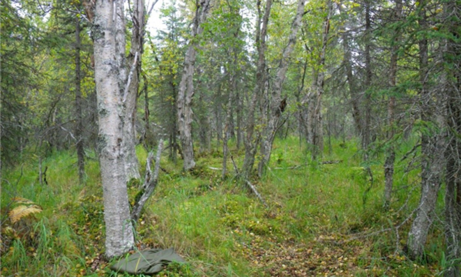
Figure 8. Typical area of community 1.1.
The reference community phase for this ecological site is characterized by a mixed coniferous and deciduous forest and an open understory of bluejoint grass (Calamagrostis canadensis) and diverse forbs and shrubs. The majority of the tree cover is in the tall and medium strata. Typically, the dominant species are white spruce (Picea glauca) and paper birch (Betula papyrifera), but other trees such as Alaska paper birch (Betula neoalaskana), Kenai birch (Betula papyrifera var. kenaica), and balsam poplar (Populus balsamifera) may be present. The dominant understory species include bluejoint grass (Calamagrostis canadensis), arctic raspberry (Rubus arcticus), spreading woodfern (Dryopteris expansa), and horsetails (Equisetum spp.). Other less abundant species may include highbush cranberry (Viburnum edule), alder (Alnus spp.), and spirea (Spiraea stevenii). Feathermosses, such as splendid feathermoss (Hylocomium splendens) and knights plume moss (Ptilium crista-castrensis), commonly are on the surface along with a minor amount of lichens. Other ground cover commonly includes herbaceous litter (about 65 percent average cover) and woody litter (about 9 percent average cover). About 1 percent is bare soil.
Dominant plant species
-
white spruce (Picea glauca), tree
-
paper birch (Betula papyrifera), tree
-
squashberry (Viburnum edule), shrub
-
bluejoint (Calamagrostis canadensis), grass
Community 1.2
Paper birch-Kenai birch-balsam poplar/alder-willow/bluejoint grass/horsetail forest
Figure 9. Typical area of community 1.2.

Figure 10. Constancy and canopy cover of plant species in community 1.2.
This late flooding community phase is characterized by a deciduous forest and an understory of dominantly bluejoint grass (Calamagrostis canadensis) and various shrubs and forbs. Commonly, two or more deciduous species are present, including balsam poplar (Populus balsamifera), paper birch (Betula papyrifera), Kenai birch (Betula papyrifera var. kenaica), and Alaska paper birch (Betula neoalaskana). The understory commonly includes bluejoint grass (Calamagrostis canadensis), arctic raspberry (Rubus arcticus), alder (Alnus spp.), and horsetails (Equisetum spp.). Other less common understory species include various shade-tolerant, competitive forbs such are arctic starflower (Trientalis europaea), spreading woodfern (Dryopteris expansa), fireweed (Chamerion angustifolium), and western touch-me-not (Impatiens noli-tangere) and colonizing highbush cranberry (Viburnum edule). The ground cover commonly consists of patchy mosses (about 20 percent average cover) and a minor component of lichens (about 1 percent). Other ground cover commonly includes herbaceous litter (about 80 percent average cover) and woody litter (about 8 percent). About 1 percent is bare soil.
Community 1.3
Arctic raspberry-Sitka alder-willow/bluejoint grass/horsetail-fireweed open scrubland
Figure 11. Typical area of community 1.3.

Figure 12. Constancy and canopy cover of plant species in community 1.3.
This mid flooding community phase is typified by open scrubland that consists of a mix of shrubs and large open areas of bluejoint grass (Calamagrostis canadensis) and pioneer, disturbance-loving forbs. Common medium and tall shrubs include alders (Alnus spp.) and tealeaf willow (Salix pulchra). Regenerating and hardy trees that survived previous periods of flooding may be present and can include any or all of the species in the reference community phase. Open areas consist dominantly of bluejoint grass, but commonly include American red raspberry (Rubus idaeus), fireweed (Chamerion angustifolium), kneeling angelica (Angelica genuflexa), and horsetails (Equisetum spp.). The ground cover may include myriad mosses (about 50 percent average cover), herbaceous litter (about 65 percent), and woody litter (about 4 percent). As much as 1 percent is bare soil.
Community 1.4
Forb/graminoid meadowThis early flooding community phase typically is characterized by pioneer, disturbance-loving forbs and graminoids. These fast-growing plants typically spread by water- or wind-borne seeds, which allows for rapid colonization after a disturbance. Graminoids may include bluejoint grass (Calamagrostis canadensis) and various sedges (Carex spp.). Many species of forbs may be present, including fireweed (Chamerion angustifolium), horsetails (Equisetum spp.), and goldenrods (Solidago spp.). Hardy individual shrubs and trees that survived periods of flooding may be present.
Note: This early flooding community phase was not observed in the field. This description is based on published literature and similar early post-flooding community phases on flood plains in southwestern Alaska.Pathway 1.1a
Community 1.1 to 1.4Major flooding can inundate the flood plains and cause erosion, deposition of sediment, and scouring of vegetation. Rare post-flood periods of ponding may also affect the composition of the plant community and result in transitions. Forbs and graminoids may colonize, and some water-tolerant trees and shrubs may survive. The frequency of flooding is rare or occasional. The white spruce (<a class="species-link" href="https://plants.usda.gov/core/profile?symbol=PIGL" target="_blank" title="Open in plants.usda.gov"><i>Picea glauca</i></a>) trees are 55 to 200 years old or more (mean age of 105 years), which suggests that the typical major flood regime is once per century (100 years).
Pathway 1.2a
Community 1.2 to 1.1
Paper birch-Kenai birch-balsam poplar/alder-willow/bluejoint grass/horsetail forest
Mixed birch-white spruce/bluejoint grass/horsetails-woodfern/alder-spirea forestNatural succession: Normal time and growth without disruptive flooding. Over time white spruce trees will increase in size and abundance and outcompete willow and alder for light and space; thus, the population of these species will decline. The period needed for this transition currently is unknown, but it likely is determined partially by the spread and growth rate of white spruce.
Pathway 1.2b
Community 1.2 to 1.4Flooding. Although the flooding regime of this ecological site is very rare to occasional, a flood occurring within about 45 to 75 years of the last major flood likely will have effects similar to those described for transition pathway 1.1a.
Pathway 1.3a
Community 1.3 to 1.2
Arctic raspberry-Sitka alder-willow/bluejoint grass/horsetail-fireweed open scrubland
Paper birch-Kenai birch-balsam poplar/alder-willow/bluejoint grass/horsetail forestNatural succession: Normal time and growth without disruptive flooding. Over time without further flooding, the abundance and diversity of existing, colonizing shrubs and trees that are competitive will increase. The diversity of graminoids and forbs may increase also as new ecological niches expand. The period needed for this transition is unknown, but it likely depends at least partially on the colonization and growth rate of shrubs and trees.
Pathway 1.3b
Community 1.3 to 1.4Flooding. Although the frequency of flooding is very rare to occasional, flooding of plant community 1.3 likely will have effects similar to those described for pathway 1.2a. The probability of more than one flood occurring in a short period is relatively low.
Pathway 1.4a
Community 1.4 to 1.3Natural succession: Normal time and growth without disruptive flooding. Over time shrubs likely will colonize and spread. The populations of existing forbs competing for space and sunlight may decrease, but the overall richness of the forbs is expected to increase as niches increase. Graminoids, particularly bluejoint grass, will continue to thrive.
State 2
Beaver-affected AreasThis alternate state is a result of ponding from beaver activity. Beavers (Castor canadensis) directly kill trees and large shrubs to use for food and dam construction and indirectly kill these species and others by raising the water table (USDA–FS, 2013). Ponding generally creates a vegetative community that is different from those normally on these flood plains. This plant community commonly includes resilient individual extant species present in the reference community phase and pioneer hydrophilic species. Permanent ponding associated with areas upstream from beaver dams can negate the influence of flooding on the soils and vegetation. The vegetative community is likely to remain relatively stable until the dam is removed. When the dam is removed by natural events, beaver abandonment, or human intervention, it is thought that the plant community will revert to the reference state. Further research is needed to quantify the outcome of dam removal in situ .
Moderate or severe browsing of willow by moose has been observed on this alternate state community. The browsing may prevent willows from becoming dominant and maintain the community as open woodland rather than transitioning to closed scrubland.Community 2.1
Paper birch/bluejoint grass/tealeaf willow/horsetails-purple marshlocks woodland
Figure 13. Typical area of community 2.1.

Figure 14. Constancy and canopy cover of plant species in community 2.1.
This community phase is associated with areas surrounding beaver ponds. It is characterized by open woodland that has disturbance-loving, hydrophilic species in the understory and in non-treed areas. The woodland generally consists dominantly of Alaska paper birch (Betula neoalaskana) in the medium and regenerative strata. The understory and open areas commonly support species such as bluejoint grass (Calamagrostis canadensis), purple marshlocks (Comarum palustre), tealeaf willow (Salix pulchra), and arctic raspberry (Rubus arcticus). Less dominant understory species include various willows (Salix spp.), horsetails (Equisetum spp.), spreading woodfern (Dryopteris expansa), and fireweed (Chamerion angustifolium). The ground cover typically consists of clusters of moss (about 25 percent average cover), herbaceous litter (about 95 percent), woody litter (about 2 percent), and rock fragments (about 1 percent). About 5 percent is bare soil.
Note: The vegetation and soils in two areas of this plant community phase were sampled. Due to the limited data available, personal field observations were used to aid in describing the community.Transition T1A
State 1 to 2This transition is caused by the damming of a water source by beavers. Areas surrounding beaver ponds may support plant assemblages distinct from those typically on these high flood plains. The vegetative community generally is comprised of species that are water tolerant and can reproduce in wet soils. Areas surrounding beaver ponds may be susceptible to flooding or ponding after rainfall and snowmelt. This prevents the vegetative community from supporting non-hydrophilic species, which may keep the composition of the plant community relatively stable. The time required for this transition depends on the presence and activity of beavers.
Restoration pathway R2A
State 2 to 1This restorative pathway to the reference state occurs in areas where a beaver dam is removed. This can be a result of flooding, inactivity by beavers, or anthropogenic activity. Once a dam is removed, the plant community is expected to transition back to the reference state. This depends on factors such as the existing seed bank, propagule recruitment, and return of the natural flooding regime. Further research and in situ documentation is needed to fully describe this pathway.
Additional community tables
Table 7. Community 1.1 plant community composition
Group Common name Symbol Scientific name Annual production () Foliar cover (%) Table 8. Community 1.1 forest overstory composition
Common name Symbol Scientific name Nativity Height ft Canopy cover (%) Diameter in Basal area (square ft/acre) Treepaper birch BEPA Betula papyrifera – – 30-35 – 0 Kenai birch BEPAK Betula papyrifera var. kenaica – – 30-35 – 0 white spruce PIGL Picea glauca – – 20-25 – 0 Table 9. Community 1.1 forest understory composition
Common name Symbol Scientific name Nativity Height (ft) Canopy cover (%) Shrub/Subshrubsquashberry VIED Viburnum edule – – 5–10 arctic raspberry RUAR Rubus arcticus – – 5–10 Table 10. Community 1.2 plant community composition
Group Common name Symbol Scientific name Annual production () Foliar cover (%) Table 11. Community 1.3 plant community composition
Group Common name Symbol Scientific name Annual production () Foliar cover (%) Table 12. Community 1.4 plant community composition
Group Common name Symbol Scientific name Annual production () Foliar cover (%) Table 13. Community 2.1 plant community composition
Group Common name Symbol Scientific name Annual production () Foliar cover (%) Interpretations
Supporting information
Inventory data references
NASIS modal data points Community 1.1 08AO07204 08SS10101 08SS11402 09AO10004 Community 1.2 09SS10401 08SS12507 08LL07306 08LL09806 Community 1.3 09SS11305 09SS10504 Community 1.4. No data points
References
-
Viereck, L.A., C. T. Dyrness, A. R. Batten, and K. J. Wenzlick. 1992. The Alaska vegetation classification. U.S. Department of Agriculture, Forest Service, Pacific Northwest Forest and Range Experiment Station General Technical Report PNW-GTR-286..
Other references
Kautz, D.R., P. Taber, and S. Nield, editors. 2012. Land Resource Regions and Major Land Resource Areas of Alaska. United States Department of Agriculture, Natural Resources Conservation Service (USDA–NRCS).
PRISM Climate Group. (PRISM) Oregon State University. https://prism.oregonstate.edu. Date created October 2018. Accessed 3 Mar 2023.
Rood, Steward B., Lori A. Goater, John M. Mahoney, Cheryl M. Pearce, and Derald G. Smith. 2007. Floods, fire, and ice: Disturbance ecology of riparian cottonwoods. Canadian Journal of Botany 85(11): 1,019-1,032
Scenarios Network for Alaska and Arctic Planning (SNAP). Historical Monthly Temperature – 1km, 1901-2009. http://ckan.snap.uaf.edu/dataset/. Accessed 20 Mar 2023.
Scenarios Network for Alaska and Arctic Planning (SNAP). Historical monthly and derived precipitation products downscaled from CRU TS data via the delta methods – 2km, 1901-2009. http://ckan.snap.uaf.edu/dataset/. Accessed 20 Mar 2023.
US Environmental Protection Agency (EPA). Level III Ecoregions of the Conterminous United States. UP ESP Office of Research and Development. Corvallis, OR. http://edg.epa.gov/. Created 16 Apr 2013. Accessed 20 Mar 2023.
Soil Survey Staff. 2013. Simplified Guide to Soil Taxonomy. USDA-Natural Resources Conservation Service, National Soil Survey Center, Lincoln, NE.
U.S. Department of Agriculture, Forest Service, Alaska Region. 2013. Forest health conditions in Alaska - 2012. Publication R10-PR-32.
United States Department of Agriculture, Natural Resources Conservation Service. 2006. Land Resource Regions and Major Land Resource Areas of the United States, the Caribbean, and the Pacific Basin. U.S. Department of Agriculture Handbook 296.
US Environmental Protection Agency (EPA). Level III Ecoregions of the Conterminous United States. UP ESP Office of Research and Development. Corvallis, OR. http://edg.epa.gov/. Created 16 Apr 2013. Accessed 20 Mar 2023.
Wohl, Ellen. 2007. Review of effects of large floods in resistant-boundary channels. In Gravel-Bed Rivers VI: From Process Understandingto River Restoration, Volume 11. H. Habersack, H. Piégay, and M. Rinaldi, editors. Elsevier Science, Amsterdam. Pages 181-211.
Yarie, John, Leslie Viereck, Keith Van Cleve, and Phyllis Adams. 1998. Flooding and ecosystem dynamics along the Tanana River.BioScience 48(9): 690-695.
Viereck, L.A., C.T. Dyrness, A.R. Batten, and K.J. Wenzlick. 1992. The Alaska vegetation classification. Gen. Tech. Rep. PNW-GTR-286. Portland, OR: U.S. Department of Agriculture, Forest Service, Pacific Northwest Research Station. 278 p.Contributors
Phil Barber
Stephanie Schmit
Sue Tester
Kendra Moseley
Michael Margo
Jamin Johanson
Steff ShoemakerApproval
Jamin Johanson, 2/07/2024
Rangeland health reference sheet
Interpreting Indicators of Rangeland Health is a qualitative assessment protocol used to determine ecosystem condition based on benchmark characteristics described in the Reference Sheet. A suite of 17 (or more) indicators are typically considered in an assessment. The ecological site(s) representative of an assessment location must be known prior to applying the protocol and must be verified based on soils and climate. Current plant community cannot be used to identify the ecological site.
Author(s)/participant(s) Contact for lead author Date 09/24/2026 Approved by Approval date Composition (Indicators 10 and 12) based on Annual Production Indicators
-
Number and extent of rills:
-
Presence of water flow patterns:
-
Number and height of erosional pedestals or terracettes:
-
Bare ground from Ecological Site Description or other studies (rock, litter, lichen, moss, plant canopy are not bare ground):
-
Number of gullies and erosion associated with gullies:
-
Extent of wind scoured, blowouts and/or depositional areas:
-
Amount of litter movement (describe size and distance expected to travel):
-
Soil surface (top few mm) resistance to erosion (stability values are averages - most sites will show a range of values):
-
Soil surface structure and SOM content (include type of structure and A-horizon color and thickness):
-
Effect of community phase composition (relative proportion of different functional groups) and spatial distribution on infiltration and runoff:
-
Presence and thickness of compaction layer (usually none; describe soil profile features which may be mistaken for compaction on this site):
-
Functional/Structural Groups (list in order of descending dominance by above-ground annual-production or live foliar cover using symbols: >>, >, = to indicate much greater than, greater than, and equal to):
Dominant:
Sub-dominant:
Other:
Additional:
-
Amount of plant mortality and decadence (include which functional groups are expected to show mortality or decadence):
-
Average percent litter cover (%) and depth ( in):
-
Expected annual annual-production (this is TOTAL above-ground annual-production, not just forage annual-production):
-
Potential invasive (including noxious) species (native and non-native). List species which BOTH characterize degraded states and have the potential to become a dominant or co-dominant species on the ecological site if their future establishment and growth is not actively controlled by management interventions. Species that become dominant for only one to several years (e.g., short-term response to drought or wildfire) are not invasive plants. Note that unlike other indicators, we are describing what is NOT expected in the reference state for the ecological site:
-
Perennial plant reproductive capability:
Print Options
Sections
Font
AAAAOther
PrintThe Ecosystem Dynamics Interpretive Tool is an information system framework developed by the USDA-ARS Jornada Experimental Range, USDA Natural Resources Conservation Service, and New Mexico State University.
Accessibility statement


