
Natural Resources
Conservation Service
Ecological site XA232X01Y204
Boreal Forest Loamy Flood Plain High
Last updated: 5/18/2020
Accessed: 09/16/2026
-
Search


Major Land Resource Area or ecological site by name and/or ID.
General information
Provisional. A provisional ecological site description has undergone quality control and quality assurance review. It contains a working state and transition model and enough information to identify the ecological site.
MLRA notes
Major Land Resource Area (MLRA): 232X–Yukon Flats Lowlands
The Yukon Flats Lowlands MLRA is an expansive basin characterized by numerous levels of flood plains and terraces that are separated by minimal breaks in elevation. This MLRA is in Interior Alaska and is adjacent to the middle reaches of the Yukon River. Numerous tributaries of the Yukon River are within the Yukon Flats Lowlands MLRA. The largest are Beaver Creek, Birch Creek, Black River, Chandalar River, Christian River, Dall River, Hadweenzic River, Hodzana River, Porcupine River, and Sheenjek River. The MLRA has two distinct regions—lowlands and marginal uplands. The lowlands have minimal local relief and are approximately 9,000 square miles in size (Williams 1962). Landforms associated with the lowlands are flood plains and stream terraces. The marginal uplands consist of rolling and dissected plains that are a transitional area between the lowlands and adjacent mountain systems. The marginal uplands are approximately 4,700 square miles in size (Williams 1962).
This MLRA is bounded by the Yukon-Tanana Plateau to the south, Hodzana Highlands to the west, Porcupine Plateau to the east, and southern foothills of the Brooks Range to the north (Williams 1962). These surrounding hills and mountains partially isolate the Yukon Flats Lowlands MLRA from weather systems affecting other MLRAs of Interior Alaska. As a result, temperatures are generally warmer in summer and colder in winter than is characteristic in other areas at comparable latitude. There is a moisture and temperature gradient in which the lowlands region tends to be drier and colder and the surrounding marginal uplands region tends to be moister and warmer (PRISM Climate Group 2006).
The Yukon Flats Lowlands MLRA is mostly undeveloped lands that are sparsely populated and not accessible by a road system. A number of villages, including Beaver, Birch Creek, Chalkyitsik, Circle, Fort Yukon, Stevens Village, and Venetie, are adjacent to the Yukon River or one of its major tributaries. The largest village is Fort Yukon, which according to the 2010 U.S. Census has 583 residents that are dominantly Gwich’in Alaska Natives.LRU notes
Alaska has no officially recognized LRU. However, there appear to be two distinct LRU in the Yukon Flats Lowlands MLRA. These LRU are thought to have differing climatic regimes, landforms, and soil types (STATSGO and Jorgensen and Meidinger 2015). The two LRU were previously discussed in the MLRA notes section above and are termed the lowlands LRU and the marginal uplands LRU.
This ecological site is associated with the lowlands LRU.Classification relationships
Yukon Flats Lowlands MLRA.
Ecological site concept
This ecological site is associated with the high flood plain of major tributaries in the Yukon Flats Lowlands MLRA. In this MLRA, the flood plains of major tributaries have been divided into having low, middle, and/or high positions. When compared to low and middle flood plain, the high flood plain has less frequent and shorter duration flood events. Flooding occurs occasionally (5 to 50 times in 100 years) for brief durations of time (between 2 and 7 days). Associated soils are considered well drained. The reference state supports multiple communities related to flooding, fire, and tree throw.
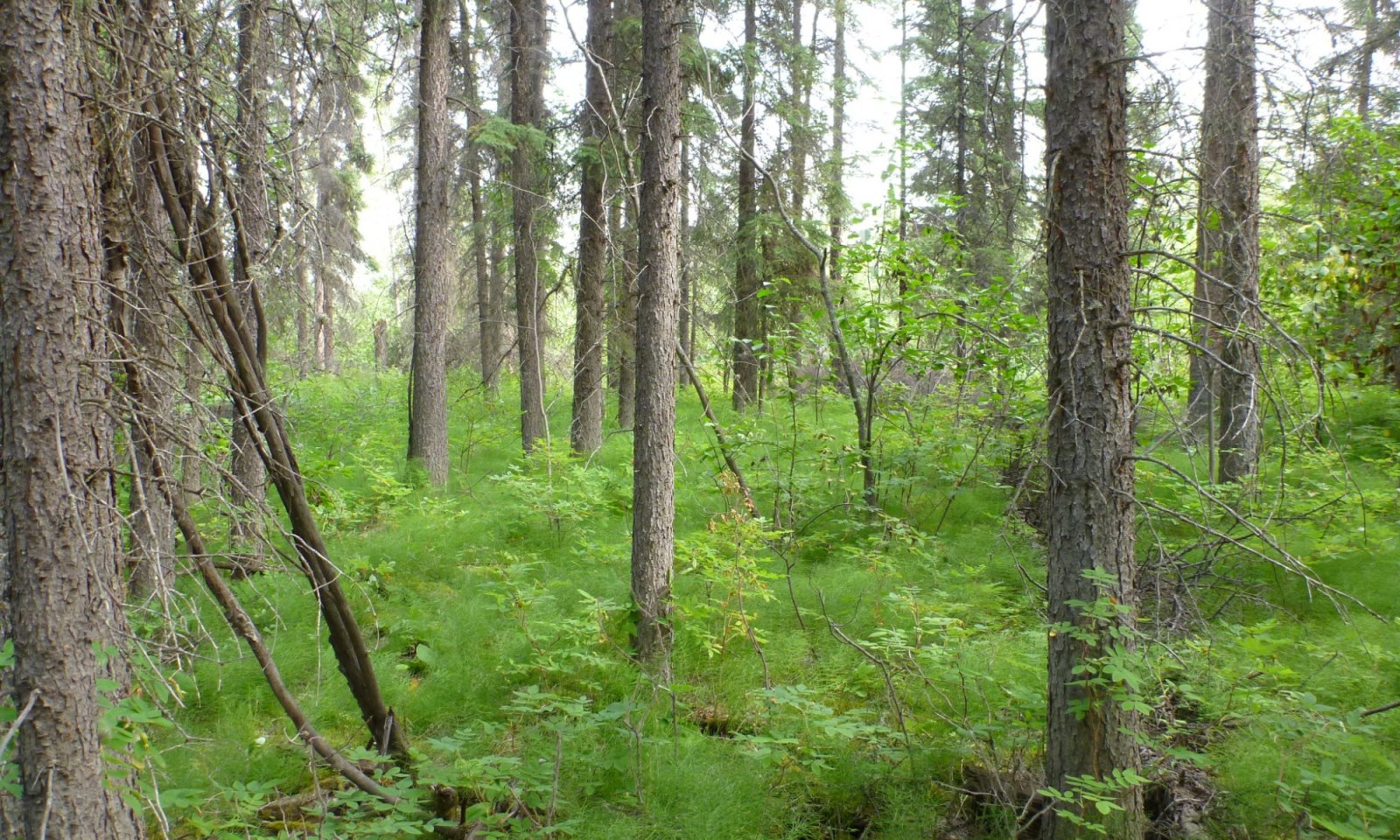
Reference plant community 1.1 is characterized as an open needleleaf forest (25 to 60 percent cover) primarily composed of mature white spruce (Picea glauca). Commonly observed understory species include prickly rose (Rosa acicularis), squashberry (Viburnum edule), twinflower (Linnaea borealis), a mixture of alder species (Alnus spp.), a mixture of horsetail species (Equisetum spp.), tall bluebell (Mertensia paniculata), and splendid feathermoss (Hylocomium splendens).Associated sites
XA232X01Y218 Boreal Woodland Loamy Frozen Terraces
This ecological site is associated with wet soils on the tread of stream terraces in Yukon Flats Lowlands MLRA. Soils generally have permafrost at moderate depth (20 to 40 inches) and pond occasionally for long durations of time. The reference plant community is characterized as a needleleaf woodland (10 to 25 percent cover; Viereck et al. 1992) composed of black spruce (Picea mariana) and white spruce (Picea glauca).
XA232X01Y222 Boreal Graminoid Loamy Terrace Depressions
This ecological site is associated with closed depressions of stream terraces that support a reference state with multiple graminoid-dominant plant communities. These depressions are considered closed because they are not associated with a flood regime and have limited, if any, groundwater flow or recharge. The presumed hydrological inputs for this ecological site are primarily thaw of the annual active soil layer and/or permafrost, snowmelt runoff, and precipitation. This hydrologic regime results in the development of sodic soil properties.
XA232X01Y219 Boreal Forest Loamy Terraces Moist
This ecological site is associated with moderately well drained soils on the treads of stream terraces throughout the Yukon Flats Lowlands MLRA. Flooding frequency ranges from rare to none. The reference plant community is characterized as an open needleleaf forest (25 to 60 percent cover) primarily composed of mature white spruce (Picea glauca).
XA232X01Y221 Boreal Forest Loamy Terraces
This ecological site is associated with well drained soils on the treads of stream terraces throughout the Yukon Flats Lowlands MLRA. Flooding frequency ranges from rare to none. The reference plant community is characterized as an open needleleaf forest (25 to 60 percent cover) primarily composed of mature white spruce (Picea glauca).
XA232X01Y280 Boreal Scrub Loamy Flood Plain Wet
This ecological site is associated with the flood plain and adjacent terraces of minor, low-gradient tributaries in the Yukon Flats Lowlands MLRA. The reference plant community phase is associated with soils that both pond and flood. The reference plant community phase is characterized as closed tall scrub (greater than 75 percent shrub cover; Viereck et al. 1992) primarily composed of a mixture of willow (Salix spp.).
XA232X01Y205 Boreal Grass Loamy Flood Plain Depressions
This ecological site is associated with depressions on flood plains in the Yukon Flats Lowlands MLRA. The reference state plant communities are associated with soils that both pond and flood. Ponding occurs frequently (greater than 50 times in 100 years) for long durations of time (between 7 and 30 days). Flooding occurs occasionally (5 to 50 times in 100 years) for brief durations of time (between 2 and 7 days). The reference plant community is characterized as mesic graminoid herbaceous (Viereck et al. 1992) and is primarily composed of bluejoint (Calamagrostis canadensis).
XA232X01Y206 Boreal Scrub Loamy Frozen Flood Plain Depressions
This ecological site is associated with depressions on flood plains in the Yukon Flats Lowlands MLRA. The reference state plant communities are associated with soils that both pond and flood. Ponding occurs occasionally (5 to 50 times in 100 years) for brief durations of time (between 2 and 7 days). Flooding occurs occasionally for brief durations of time. The reference plant community is characterized as open tall scrub (Viereck et al. 1992) and is primarily composed of willow (Salix spp.).
XA232X01Y250 Boreal Woodland Gravelly Terraces Dry
This ecological site is associated with somewhat excessively drained soils on the tread of gravelly stream terraces in Yukon Flats Lowlands MLRA. Gravelly horizons occur at very shallow depth (0 to 10 inches). The reference plant community is characterized as a needleleaf woodland (10 to 25 percent cover; Viereck et al. 1992) composed primarily of mature white spruce (Picea glauca).
XA232X01Y223 Boreal Scrub Loamy Frozen Terrace Depressions
This shrubby ecological site occurs in the transitional area between the forested tread of a stream terrace and the graminoid-dominant communities associated with closed, terrace depressions (ecological site R232XY222AK). This site typically occurs between the outer third and lip of these closed depressions. The reference plant community for ecological site is characterized as an open tall scrubland (Viereck et al. 1992) and those shrubs are primarily an assortment of willow (Salix spp.).
XA232X01Y209 Boreal Tussock Loamy Frozen Terraces
This ecological site is associated with wet soils on the tread of terraces throughout the Yukon Flats Lowlands MLRA. Soils commonly have permafrost at moderate depth (20 to 40 inches) and lack gravelly horizons in the profile. Soils pond frequently for very long durations. The reference plant community is characterized as open low mixed shrub-sedge tussock bog (Viereck et al. 1992).
XA232X01Y200 Boreal Scrub Loamy Flood Plain Low
Ecological site R232XY200AK is associated with the low flood plain of major tributaries in the Yukon Flats Lowlands MLRA. Flooding occurs frequently (greater than 50 times in 100 years) for long durations of time (between 7 and 30 days). The reference plant community is characterized as closed tall scrub (greater than 75 percent shrub cover; Viereck et al. 1992) primarily composed of a mixture of willow (Salix spp.) and alder (Alder spp.).
XA232X01Y202 Boreal Forest Loamy Flood Plain Middle
This ecological site is associated with the middle flood plain of major tributaries in the Yukon Flats Lowlands MLRA. Flooding occurs occasionally (5 to 50 times in 100 years) for long durations of time (between 7 and 30 days). The reference plant community is characterized as a closed deciduous forest (60-100 percent cover; Viereck et al. 1992) primarily composed of mature balsam poplar (Populus balsamifera).
Similar sites
XA232X01Y202 Boreal Forest Loamy Flood Plain Middle
XA232X01Y202 is associated with middle flood plains in the Lowlands LRU of the Yukon Flats Lowlands MLRA. When compared to XA232X01Y204, this ecological site floods more frequently and for longer durations of time. The reference state plant community is typically a closed stand of balsam poplar but can have productive white spruce trees.
XA232X01Y221 Boreal Forest Loamy Terraces
XA232X01Y221 is associated with well drained soils on stream terraces in the Lowlands LRU of the Yukon Flats Lowlands MLRA. The flood frequency for this ecological site ranges from rare to none. Reference state communities are similar but XA232X01Y221 appears to have less productive stands of trees and typically has more non-vascular plant cover.
XA232X02Y210 Boreal Forest Loamy Frozen Plains Warm
XA232X02Y210 is associated with well drained soils on slopes in the marginal uplands LRU of the Yukon Flats Lowlands MLRA. As compared to XA232X01Y204, white spruce trees associated with site XA232X02Y210 tend to grow smaller and have a lower site index.

Figure 1. A plant community sampled in a transitional area between a terrace and flood plain in the Yukon Flats Lowlands MLRA. In this transitional area, soils are undergoing the process of paludification. These plant communities are considered ecotones.
Table 2. Dominant plant species
Tree (1) Picea glauca
Shrub (1) Rosa acicularis
(2) Viburnum eduleHerbaceous (1) Equisetum
Legacy ID
F232XY204AK


