
Natural Resources
Conservation Service
Ecological site F220XY427AK
Maritime Forest Gravelly High Floodplain
Last updated: 6/05/2025
Accessed: 09/26/2026
-
Search


Major Land Resource Area or ecological site by name and/or ID.
PreviousSectionsNextGeneral information
Provisional. A provisional ecological site description has undergone quality control and quality assurance review. It contains a working state and transition model and enough information to identify the ecological site.
MLRA notes
Major Land Resource Area (MLRA): 220X–Alexander Archipelago-Gulf of Alaska Coast
The Alexander Archipelago-Gulf of Alaska Coast area consists of a narrow arc of islands and lower elevation coastal mountains in the Southern Alaska Region. This area spans from the Alexander Archipelago in southeastern Alaska, north and west along the coast of the Gulf of Alaska and Prince William Sound, and further west to the southern tip of the Kenai Peninsula and the northeastern islands of the Kodiak Archipelago. The area makes up about 27,435 square miles (USDA 2006). The terrain primarily consists of low to moderate relief mountains that are deeply incised. Throughout the area glaciers, rivers, and streams have cut deep, narrow to broad valleys. The broader valleys have nearly level to strongly sloping flood plains and stream terraces. Alluvial and colluvial fans and short footslopes are common in the valleys along the base of the mountains. Rocky headlands, sea cliffs, estuaries, and beaches are common along the coast.
This area includes the Municipality of Juneau, Alaska's capital, and a number of smaller coastal towns and villages. Federally administered lands within this MLRA include Admiralty Island National Monument and part of Misty Fjords National Monument, Tongass National Forest, Chugach National Forest, and Glacier Bay, Wrangell-St. Elias, and Kenai Fjords National Parks and Preserves. The southern terminus of the Trans-Alaska Pipeline is in Valdez.
During the late Pleistocene epoch, the entire area was covered with glacial ice. The numerous fjords of the Alexander Archipelago and Prince William Sound were formed chiefly as a result of glacial scouring and deepening of preglacial river valleys. Most glacial deposits have been eroded away or buried by mountain colluvium and alluvium, which cover about 90 percent of the present landscape. The remaining glacial and glaciofluvial deposits are generally restricted to coastal areas. During the Holocene epoch, volcanic activity within and adjacent to this area deposited a layer of volcanic ash of varying thickness on much of the landscape in the southeastern and northwestern parts of the area. Paleozoic, Mesozoic, and Lower Tertiary stratified sedimentary rocks and Cretaceous and Tertiary intrusive rocks underlie much of the area and are exposed on steep mountain
slopes and ridges (USDA 2006).
The dominant soil orders in this MLRA are Spodosols, Histosols, and Entisols. Soils in the area typically have a cryic soil temperature regime, an udic moisture regime, and have mixed minerology. Spodosols are common on mountains and hills having been formed in gravelly or cobbly colluvium, glacial till, and varying amounts of silty volcanic ash. These Spodosols commonly range from shallow to deep, are well to somewhat poorly drained, and typically classify as Humicryods or Haplocryods. Histosols that are poorly to very poorly drained occur on footslopes, discharge slopes, and valley floors. These wet histosols commonly classify as Cryosaprists, Cryohemists, and Cryofibrists. Histosols that are well drained occur on steep mountainsides. These dry Histosols commonly classify as Cryofolists. Entisols are common on flood plains, stream terraces, and outwash plains having been formed in silty, sandy, and gravelly to cobbly alluvium. These Entisols are generally deep, range from well to somewhat poorly drained, and commonly classify as Cryaquents and Cryofluvents. Miscellaneous (non-soil) areas make up about 23 percent of the MLRA. The most common miscellaneous areas are avalanche chutes, rock outcrop, rubble land, beaches, river wash, and water.
This area represents the northern extent of the Pacific temperate rainforest and is characterized by productive stands of conifers. Western hemlock and Sitka spruce are the dominant trees on mountains and hills at the lower elevations. Due to warmer temperatures, western red cedar and Alaska cedar are more prevalent in the southern part of the area. Black cottonwood and mixed forest types occur on flood plains. Areas of peat and other sites that are too wet for forest growth support sedge-grass meadows and low scrub. The transition to subalpine and alpine communities typically occurs at elevations between 1500 to 3000 feet (Boggs et al. 2010, Carstensen 2007, Martin et al. 1995), which characterize the vegetation of the Southern Alaska Coastal Mountains area.
For many decades, logging, commercial fishing, and mining have been the primary industrial land uses throughout much of the area. In recent years, changes in public interests, land use policies, and timber economics have contributed to a significant decline in the timber industry. Commercial fishing continues to be an important industry and most communities support a fleet of boats and fishing related facilities. A number of mines operate in the area and others have been prospected and proposed. Tourism and wildland recreation are becoming increasingly important. Subsistence hunting, fishing, and gathering provide food and a variety of other resources to local residents and remain the principal economy for residents of remote villages.Ecological site concept
This site occurs in river valleys and coastal plains on high flood plains adjacent to a river or stream channel. These high flood plains are rarely to frequently flooded, and may include some closed depressions where water ponds on the surface for long durations. Soil textures are stratified silt loams to loamy sands, often with lenses of gravel and sandier textures in deeper soil horizons. Relatively small, closed depressions occur on these high flood plains and often have very deep peat deposits as a result of long duration ponding. Drainage class ranges from moderately well- to well-drained, with very poor drainage in closed depressions.
This site supports a reference state composed of three communities that reflect a disturbance regime of high-intensity flooding. A tall shrub community with abundant herbaceous understory plants is typical following severe flood events. In the absence of severe flooding, the abundance of balsam poplar trees increases, and the community resembles an open forest. If flooding becomes even less frequent, Sitka spruce becomes dominant, and understory shrubs and forbs are largely displaced by moss species.Associated sites
R220XY426AK Maritime Shrub Low Flood Plain
R220XY426AK occurs downslope of this site on low flood plain positions that have more frequent and longer duration flood events.
Similar sites
R220XY426AK Maritime Shrub Low Flood Plain
Both sites occur on floodplains of rivers and streams, however, site R220XY426AK does not support tree dominance because it occurs on low flood plains with high flood frequency. By contrast, this site occurs on high flood plains and experiences less frequent flooding that enables trees to dominate over time.
Table 1. Dominant plant species
Tree (1) Picea sitchensis
Shrub (1) Vaccinium ovalifolium
Herbaceous (1) Orthilia secunda
(2) Hylocomium splendensPhysiographic features
This site occurs in river valleys and coastal plains on high flood plains associated with river and stream channels. These high flood plains are rarely to occasionally flooded. Closed depression microfeatures pond for long durations. The water table is usually more than 72 inches below the soil surface, but can rise to within 18 inches of the surface during wet periods. In ponded depressions, the water table is at or above the soil surface for long periods. Slopes typically range from 0-3% with elevations typically between sea level and 425 feet.
Table 2. Representative physiographic features
Landforms (1) River valley > Flood plain
(2) Coastal plain > Flood plain
(3) River valley > Flood plain > Closed depression
(4) Coastal plain > Flood plain > Closed depression
Runoff class Medium Flooding duration Brief (2 to 7 days) Flooding frequency Rare to occasional Ponding duration Long (7 to 30 days) Ponding frequency None Elevation 0 – 425 ft Slope 0 – 3 % Water table depth 18 – 60 in Aspect W, NW, N, NE, E, SE, S, SW Table 3. Representative physiographic features (actual ranges)
Runoff class Medium Flooding duration Very brief (4 to 48 hours) to brief (2 to 7 days) Flooding frequency Very rare to frequent Ponding duration Long (7 to 30 days) Ponding frequency None to frequent Elevation 0 – 1850 ft Slope 0 – 15 % Water table depth 0 – 60 in Climatic features
Cloudy skies, moderate temperatures, and abundant rainfall characterize the temperate maritime climate of this site. Frequent winter storms may consist of snow or heavy rainfall. Moderate to strong winds from the south and southeast are common before and during storms throughout the year. Annual precipitation ranges from 44-94 inches, and annual snowfall ranges from 30-70 inches along the coast and up to 200 inches at higher elevations (USDA 2006). The average annual temperature at lower elevations ranges from about 38-43 degrees F (3-6 degrees C). The frost-free period ranges from about 90-140 days, and the freeze-free period ranges from about 125-180 days.
Table 4 Representative climatic features
Frost-free period (characteristic range) 100-140 days Freeze-free period (characteristic range) 150-180 days Precipitation total (characteristic range) 60-150 in Frost-free period (actual range) 80-170 days Freeze-free period (actual range) 120-220 days Precipitation total (actual range) 40-170 in Frost-free period (average) 120 days Freeze-free period (average) 170 days Precipitation total (average) 100 in Characteristic rangeActual rangeBarLineFigure 1. Monthly precipitation range
Characteristic rangeActual rangeBarLineFigure 2. Monthly minimum temperature range
Characteristic rangeActual rangeBarLineFigure 3. Monthly maximum temperature range
BarLineFigure 4. Monthly average minimum and maximum temperature
Figure 5. Annual precipitation pattern
Figure 6 Annual average temperature pattern
Climate stations used
-
(1) GUSTAVUS [USW00025322], Gustavus, AK
-
(2) GLACIER BAY [USC00503294], Gustavus, AK
-
(3) YAKUTAT STATE AP [USW00025339], Yakutat, AK
-
(4) SKAGWAY AP [USW00025335], Skagway, AK
-
(5) HAINES AP [USW00025323], Haines, AK
-
(6) SELDOVIA AP [USW00025516], Homer, AK
-
(7) MAIN BAY [USC00505604], Valdez, AK
-
(8) CORDOVA M K SMITH AP [USW00026410], Cordova, AK
-
(9) SITKA AIRPORT [USW00025333], Sitka, AK
-
(10) JUNEAU INTL AP [USW00025309], Juneau, AK
-
(11) ANNETTE ISLAND AP [USW00025308], Metlakatla, AK
-
(12) PETERSBURG 1 [USW00025329], Petersburg, AK
-
(13) KETCHIKAN INTL AP [USW00025325], Ketchikan, AK
-
(14) PELICAN [USC00507141], Hoonah, AK
">Influencing water features
The hydrology of this site is characterized by rare to occasional freshwater flooding during spring runoff and other large storm events. In the event that high-intensity flooding removes vegetation on this site, which occurs less frequently than on the adjacent low flood plain site, the result is several years to decades of alder and willow cover followed by a gradual increase in tree cover. Closed depressions on the flood plain are frequently ponded for long durations.
Soil features
The soils of this site formed in deep alluvial deposits on high flood plains by freshwater rivers and streams. Soil textures are stratified silt loams to loamy sands, often with lenses of gravel and sandier textures in deeper soil horizons. A thin organic layer is common on the soil surface. Relatively small, closed depressions occur on these high flood plains, and often have very deep peat deposits as a result of long duration ponding. These soils are typically moderately well- and well-drained, with very poor drainage in closed depressions. The soil moisture regime of this site is udic or oxyaquic except in depressions, which are aquic.

Figure 7. Typical soil profile for Bertha soils in Glacier Bay National Park and Preserve-Gustavus Area, Alaska.
Table 5. Representative soil features
Parent material (1) Alluvium
(2) Organic material
Surface texture (1) Loamy sand
(2) Silt loam
(3) Sandy loam
(4) Gravelly sand
(5) Peat
Family particle size (1) Coarse-loamy over sandy or sandy-skeletal
(2) Sandy
(3) Ashy over sandy or sandy-skeletal
(4) Sandy-skeletal
Drainage class Moderately well drained to well drained Permeability class Moderately rapid to rapid Depth to restrictive layer 60 – 0 in Soil depth 60 – 0 in Surface fragment cover <=3" Not specified Surface fragment cover >3" Not specified Available water capacity
(0-10in)0.2 – 2.7 in Calcium carbonate equivalent
(0-40in)Not specified Clay content
(0-20in)1 – 7 % Electrical conductivity
(0-40in)Not specified Sodium adsorption ratio
(0-40in)Not specified Soil reaction (1:1 water)
(0-40in)4.5 – 7.3 Subsurface fragment volume <=3"
(0-60in)0 – 50 % Subsurface fragment volume >3"
(0-60in)0 – 15 % Table 6. Representative soil features (actual values)
Drainage class Very poorly drained to well drained Permeability class Moderately rapid to very rapid Depth to restrictive layer 60 – 0 in Soil depth 60 – 0 in Surface fragment cover <=3" 0 – 5 % Surface fragment cover >3" 0 – 7 % Available water capacity
(0-10in)0.1 – 4.8 in Calcium carbonate equivalent
(0-40in)0 – 1 % Clay content
(0-20in)0 – 7 % Electrical conductivity
(0-40in)0 – 2 mmhos/cm Sodium adsorption ratio
(0-40in)0 Soil reaction (1:1 water)
(0-40in)3.5 – 8.4 Subsurface fragment volume <=3"
(0-60in)0 – 69 % Subsurface fragment volume >3"
(0-60in)0 – 47 % Ecological dynamics
This site is associated with flood plains of large rivers and tributaries along the Gulf of Alaska. Until about 10,000 years ago, this area had many continental-scale ice sheets that advanced and retreated many times over millennia (Chapin 1994). The final advance of these glaciers occurred during the Little Ice Age, which peaked about 1750 AD. Since then, many glaciers have thinned and retreated inland, while numerous tidewater glaciers still exist in the area (Lawson 2015). The 250-year glacial retreat is attributed to less regional snowfall in the mountains, rising winter temperatures, and decreased cloud cover and lower precipitation during the growing season in summer (Hall et al. 2003).
During the past 250 years of glacial retreat, meltwater transported and deposited a large amount of silt and sediment via numerous short, high-gradient rivers. Alluvial and colluvial fans and long footslopes are common in the valleys along the base of the mountains. The flood plains in this area are generally broad and braided with a high gradient, and feed into the tidally influenced estuarine areas.
This site supports a reference state composed of three communities that are each impacted by a flood regime. A tall shrub community with abundant herbaceous understory plants typically occurs following severe flood events. In the absence of severe flooding, tree seedling establish and grow. The abundance of balsam poplar trees increases, and the community resembles an open forest. With enough time and a lack of severe flood events, Sitka spruce becomes dominant and understory shrubs and forbs are largely displaced by moss species.
Browsing by moose on willow species was observed on this ecological site, but it does not appear to affect the ecological processes enough to alter the communities.State and transition model
More interactive model formats are also available. View Interactive Models
Click on state and transition labels to scroll to the respective textEcosystem states
SWAPAEHState 1 submodel, plant communities
1.1a - High-intensity flood events remove vegetation 1.2a - Lack of high-intensity flood events leading to secondary succession. 1.2b - High-intensity flood events remove vegetation 1.3a - Lack of high-intensity flood events leading to secondary succession. State 1
Reference State
Figure 8. Typical plant community associated with community 1.1.
The reference state has three community phases that transition along reversible pathways related to flooding frequency and intensity.
Resilience management. This state has been observed to be resilient and/or resistant to current disturbance drivers, lacking alternative states and at-risk communities.
Dominant plant species
-
Sitka spruce (Picea sitchensis), tree
-
balsam poplar (Populus balsamifera), tree
-
Sitka alder (Alnus viridis ssp. sinuata), shrub
-
Sitka willow (Salix sitchensis), shrub
-
splendid feather moss (Hylocomium splendens), other herbaceous
-
Schreber's big red stem moss (Pleurozium schreberi), other herbaceous
-
field horsetail (Equisetum arvense), other herbaceous
-
largeleaf avens (Geum macrophyllum), other herbaceous
Community 1.1
Sitka spruce/oval-leaf blueberry/splendid feathermoss-Schreber’s big red stem moss
Figure 9. Typical plant community associated with community 1.1.
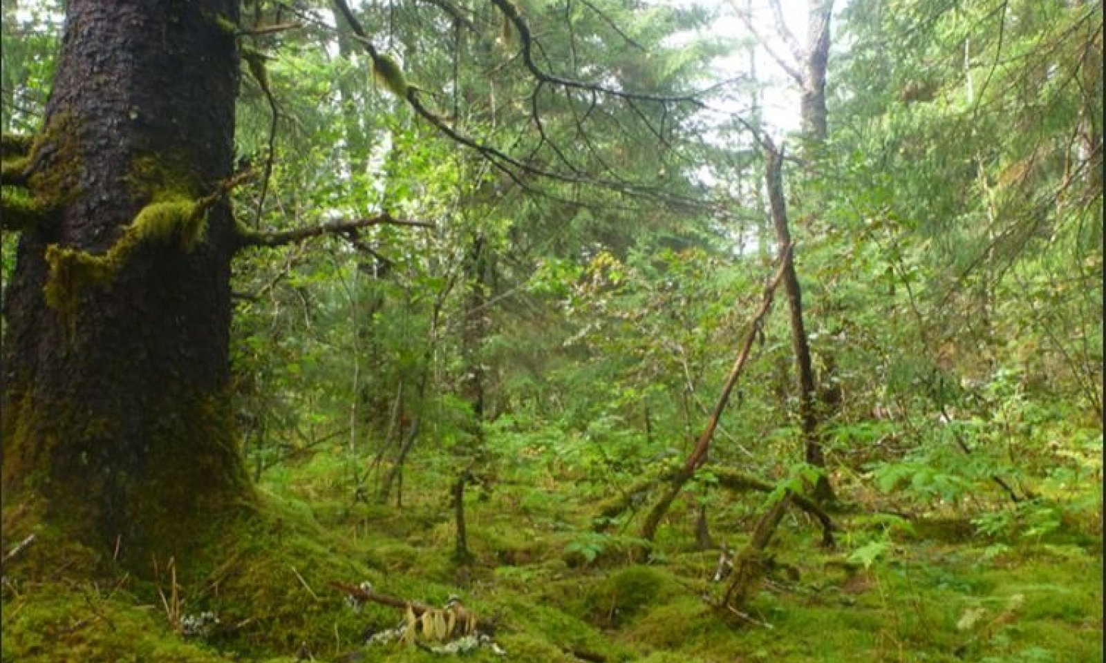
Community 1.1 is characterized as an open needleleaf forest. Sitka spruce is the most common overstory species. Western hemlock and mountain hemlock in the tall tree stratum may be present but not dominant. The understory consists of high moss cover and low shrub and forb cover. Common shrubs include oval-leaf blueberry and Sitka alder and common forbs include sidebells wintergreen, clubmoss, and claspleaf twistedstalk. The soil surface is primarily covered in Schreber’s big red stem moss, splendid feathermoss, and Dicranum moss.
Resilience management. This phase has been observed to be resilient and/or resistant to current disturbance drivers, lacking alternative states and at-risk communities.
Dominant plant species
-
Sitka spruce (Picea sitchensis), tree
-
western hemlock (Tsuga heterophylla), tree
-
oval-leaf blueberry (Vaccinium ovalifolium), shrub
-
Sitka alder (Alnus viridis ssp. sinuata), shrub
-
splendid feather moss (Hylocomium splendens), other herbaceous
-
Schreber's big red stem moss (Pleurozium schreberi), other herbaceous
-
sidebells wintergreen (Orthilia secunda), other herbaceous
-
claspleaf twistedstalk (Streptopus amplexifolius), other herbaceous
Table 7. Soil surface cover
Tree basal cover 0-0% Shrub/vine/liana basal cover 0% Grass/grasslike basal cover 0% Forb basal cover 0% Non-vascular plants 80-90% Biological crusts 0% Litter 10-20% Surface fragments >0.25" and <=3" 0% Surface fragments >3" 0% Bedrock 0% Water 0% Bare ground 0% Community 1.2
Balsam poplar/Sitka alder
Figure 10. Typical plant community associated with community 1.2.
Community 1.2 is an open broadleaf forest community dominated by balsam poplar and Sitka alder. Diverse shrubs and forbs are common in the understory. Common shrubs include Sitka willow and common forbs include bride’s feathers, wintergreen, field horsetail, fragrant bedstraw, and common cowparsnip. The ground cover is mostly herbaceous litter and woody debris.
Resilience management. This phase has been observed to be resilient and/or resistant to current disturbance drivers, lacking alternative states and at-risk communities.
Dominant plant species
-
balsam poplar (Populus balsamifera), tree
-
Sitka alder (Alnus viridis ssp. sinuata), shrub
-
bride's feathers (Aruncus dioicus), other herbaceous
-
wintergreen (Pyrola), other herbaceous
-
field horsetail (Equisetum arvense), other herbaceous
-
fragrant bedstraw (Galium triflorum), other herbaceous
-
largeleaf avens (Geum macrophyllum), other herbaceous
-
common cowparsnip (Heracleum maximum), other herbaceous
-
red baneberry (Actaea rubra), other herbaceous
Table 8. Soil surface cover
Tree basal cover 0% Shrub/vine/liana basal cover 0% Grass/grasslike basal cover 0% Forb basal cover 0% Non-vascular plants 0-10% Biological crusts 0% Litter 90-100% Surface fragments >0.25" and <=3" 0% Surface fragments >3" 0% Bedrock 0% Water 0% Bare ground 0% Community 1.3
Sitka alder-Sitka willow/field horsetail-largeleaf avens
Figure 11. Community 1.3 dominated by Sitka alder with diverse herbaceous understory.

Figure 12. Landscape photo of community 1.3 on the high flood plain (right), with evidence of very large flood event scouring low flood plain site (left, R220XY426AK).
Community 1.3 is a closed tall scrub community dominated by Sitka alder and Sitka willow. Diverse herbaceous species are common in the understory, with the most common being field horsetail and largeleaf avens. The ground cover is mostly herbaceous litter and woody debris.
Resilience management. This phase has been observed to be resilient and/or resistant to current disturbance drivers, lacking alternative states and at-risk communities.
Dominant plant species
-
Sitka alder (Alnus viridis ssp. sinuata), shrub
-
Sitka willow (Salix sitchensis), shrub
-
field horsetail (Equisetum arvense), other herbaceous
-
largeleaf avens (Geum macrophyllum), other herbaceous
-
liverleaf wintergreen (Pyrola asarifolia), other herbaceous
-
common cowparsnip (Heracleum maximum), other herbaceous
Table 9. Soil surface cover
Tree basal cover 0% Shrub/vine/liana basal cover 0% Grass/grasslike basal cover 0% Forb basal cover 0% Non-vascular plants 0-30% Biological crusts 0% Litter 70-100% Surface fragments >0.25" and <=3" 0% Surface fragments >3" 0-0% Bedrock 0% Water 0% Bare ground 0-10% Pathway 1.1a
Community 1.1 to 1.3
Sitka spruce/oval-leaf blueberry/splendid feathermoss-Schreber’s big red stem moss
Sitka alder-Sitka willow/field horsetail-largeleaf avensPrimary trigger: high-intensity flood event Ecological process: tall shrub cover is mechanically reduced by force of floodwaters, resulting in higher resource availability for herbaceous species, including light, heat, and space. Secondary trigger: N/A Indicators: flood indicators, such as lodged debris, soil scouring, fresh sediment deposits, and open plant community structure.
Pathway 1.2a
Community 1.2 to 1.1
Balsam poplar/Sitka alder
Sitka spruce/oval-leaf blueberry/splendid feathermoss-Schreber’s big red stem mossEcological process: tree cover increases due to natural succession, such that strong competitors (Sitka spruce) reduce the availability of light, heat, and space for less competitive understory species. Primary trigger: none Secondary trigger: N/A Indicators: mature Sitka spruce and very high cover of moss on the soil surface.
Pathway 1.2b
Community 1.2 to 1.3
Balsam poplar/Sitka alder
Sitka alder-Sitka willow/field horsetail-largeleaf avensPrimary trigger: high-intensity flood event Ecological process: Balsam poplar cover is mechanically reduced by force of floodwaters, resulting in higher resource availability for shrub and herbaceous species, including light, heat, and space. Secondary trigger: N/A Indicators: flood indicators, such as lodged debris, soil scouring, fresh sediment deposits, and open plant community structure.
Pathway 1.3a
Community 1.3 to 1.2
Sitka alder-Sitka willow/field horsetail-largeleaf avens
Balsam poplar/Sitka alderEcological process: cover increases due to natural succession, such that strong competitors (balsam poplar) reduce the availability of light, heat, and space for less competitive understory species. Primary trigger: none Secondary trigger: N/A Indicators: mature balsam poplar in the overstory and high diversity of understory shrubs and herbaceous species.
Additional community tables
Table 10. Community 1.1 plant community composition
Group Common name Symbol Scientific name Annual production () Foliar cover (%) Table 11. Community 1.1 forest overstory composition
Common name Symbol Scientific name Nativity Height ft Canopy cover (%) Diameter in Basal area (square ft/acre) TreeSitka spruce PISI Picea sitchensis Native 38-93 40-65 5.7-18.2 0 western hemlock TSHE Tsuga heterophylla Native – 0-15 – 0 Table 12. Community 1.1 forest understory composition
Common name Symbol Scientific name Nativity Height (ft) Canopy cover (%) Forb/Herbsidebells wintergreen ORSE Orthilia secunda Native – 3–4 wintergreen PYROL Pyrola Native – 0–4 claspleaf twistedstalk STAM2 Streptopus amplexifolius Native – 0–3 bride's feathers ARDI8 Aruncus dioicus Native – 0–2 Fern/fern allyclubmoss LYCOP2 Lycopodium Native – 0–3 spreading woodfern DREX2 Dryopteris expansa Native – 0–1 Shrub/Subshruboval-leaf blueberry VAOV Vaccinium ovalifolium Native – 0–15 salmonberry RUSP Rubus spectabilis Native – 0–4 Sitka alder ALVIS Alnus viridis ssp. sinuata Native – 0–1 Treebalsam poplar POBA2 Populus balsamifera Native – 0–1 NonvascularSchreber's big red stem moss PLSC70 Pleurozium schreberi Native – 40–45 splendid feather moss HYSP70 Hylocomium splendens Native – 35–40 dicranum moss DICRA8 Dicranum Native – 1–5 rhizomnium moss RHGL70 Rhizomnium glabrescens Native – 0–5 Table 13. Community 1.2 plant community composition
Group Common name Symbol Scientific name Annual production () Foliar cover (%) Table 14. Community 1.2 forest overstory composition
Common name Symbol Scientific name Nativity Height ft Canopy cover (%) Diameter in Basal area (square ft/acre) Treebalsam poplar POBA2 Populus balsamifera Native – 15-25 – 0 Sitka spruce PISI Picea sitchensis Native – 0-5 – 0 Table 15. Community 1.2 forest understory composition
Common name Symbol Scientific name Nativity Height (ft) Canopy cover (%) Forb/Herbbride's feathers ARDI8 Aruncus dioicus Native – 0–15 wintergreen PYROL Pyrola Native – 0–7 sweetroot OSMOR Osmorhiza Native – 0–5 violet VIOLA Viola Native – 0–3 common cowparsnip HEMA80 Heracleum maximum Native – 0–3 aster ASTER Aster Native – 0–3 fragrant bedstraw GATR3 Galium triflorum Native – 0–3 largeleaf avens GEMA4 Geum macrophyllum Native – 1–2 buttercup RANUN Ranunculus Native – 0–2 Menzies' burnet SAME6 Sanguisorba menziesii Native – 0–2 claspleaf twistedstalk STAM2 Streptopus amplexifolius Native – 0–1 northern green orchid PLHY2 Platanthera hyperborea Native – 0–1 western rattlesnakeroot PRAL Prenanthes alata Native – 0–1 woodland buttercup RAUN Ranunculus uncinatus Native – 0–1 narcissus anemone ANNA Anemone narcissiflora Native – 0–1 sweetcicely OSBE Osmorhiza berteroi Native – 0–1 red baneberry ACRU2 Actaea rubra Native – 0–1 northern groundcone BORO Boschniakia rossica Native – 0–1 Fern/fern allyfield horsetail EQAR Equisetum arvense Native – 1–2 variegated scouringrush EQVA Equisetum variegatum Native – 0–2 Shrub/SubshrubSitka alder ALVIS Alnus viridis ssp. sinuata Native – 10–35 salmonberry RUSP Rubus spectabilis Native – 0–5 Sitka willow SASI2 Salix sitchensis Native – 0–3 devilsclub OPHO Oplopanax horridus Native – 1–3 squashberry VIED Viburnum edule Native – 0–1 blackberry RUBUS Rubus Native – 0–1 NonvascularSchreber's big red stem moss PLSC70 Pleurozium schreberi Native – 0–5 goose neck moss RHYTI2 Rhytidiadelphus Native – 0–2 Table 16. Community 1.3 plant community composition
Group Common name Symbol Scientific name Annual production () Foliar cover (%) Table 17. Community 1.3 forest understory composition
Common name Symbol Scientific name Nativity Height (ft) Canopy cover (%) Grass/grass-like (Graminoids)American dunegrass LEMO8 Leymus mollis Native – 0–10 Graminoid (grass or grass-like) 2GRAM Graminoid (grass or grass-like) Native – 0–2 Forb/Herbfield horsetail EQAR Equisetum arvense Native – 2–40 largeleaf avens GEMA4 Geum macrophyllum Native – 0–25 seacoast angelica ANLU Angelica lucida Native – 0–8 calliergon moss CALLI10 Calliergon Native – 0–5 bushy knotweed PORA3 Polygonum ramosissimum Native – 0–5 liverleaf wintergreen PYAS Pyrola asarifolia Native – 0–5 common cowparsnip HEMA80 Heracleum maximum Native – 0–3 aster ASTER Aster Native – 0–3 Shrub/SubshrubSitka alder ALVIS Alnus viridis ssp. sinuata Native – 30–70 Sitka willow SASI2 Salix sitchensis Native – 10–15 salmonberry RUSP Rubus spectabilis Native – 0–5 devilsclub OPHO Oplopanax horridus Native – 0–5 TreeSitka spruce PISI Picea sitchensis Native – 0–3 Nonvascularpolytrichum moss POLYT5 Polytrichum Native – 0–25 Moss 2MOSS Moss Native – 0–10 snow lichen STERE2 Stereocaulon Native – 0–1 Interpretations
Supporting information
Inventory data references
All data currently reside in NASIS under the User Site IDs in the following table: NASIS ID / community 13TD00402 /community 1.1 13TD06802 / community 1.1 13TD00404 / community 1.3 13NP00801 / community 1.3 13NP00802 / community 1.2 13NP02503 / community 1.2 13NP03202 / community 1.3
Other references
Chapin, F.S., L.R. Walker, C.L. Fastie, and L.C. Sharman. 1994. Mechanisms of primary succession following deglaciation at Glacier Bay, Alaska. Ecological Monographs 64: 149-175.
Clague, John J., and V.N. Rampton. 1982. Neoglacial Lake Alsek. Canadian Journal of Earth Sciences 19.1: 94-117.
Clarke, J.A. 1977. An inverse problem in glacial geology: The reconstruction of glacier thinning in Glacier Bay, Alaska, between AD 1910 and 1960 from relative sea level data. Journal of Glaciology 80: 481-503.
Hall, D.K., C.S. Benton, and W.O. Field. 1994. Changes of glaciers in Glacier Bay, Alaska, using ground and satellite measurements. Physical Geography 16(1): 27-41.
Hall, M.H.P., and D. Fagre. 2003. Modeled climate-induced glacier change in Glacier National Park 1850–2100. BioScience 53:131-140.
Hicks, S.D., and W. Shofnos. 1965. The documentation of land emergence from sea-level observations in southeast Alaska. Journal of Geophysical Research 70: 3315-3320.
Larsen, C.F., K.A. Echelmeyer, J.T. Freymueller, and R.J. Motyka. 2003. Tide gauge records of uplift along the northern Pacific-North American plate boundary, 1937 to 2001. Journal of Geophysical Research. Volume 108, number B4. doi:10.1029/2001JB001685
Lawson, D.E. 2015. An overview of selected glaciers in Glacier Bay. National Park Service. Retrieved August 15, 2010.
Milne, G.A., and I. Shennan. 2013. Isostasy: Glaciation-induced sea-level change. In Encyclopedia of Quaternary Science. Volume 3, pages 452-459. Elsevier, Oxford.
Schoeneberger, P.J., and D.A. Wysocki. 2012. Geomorphic Description System, Version 4.2. Natural Resources Conservation Service, National Soil Survey Center, Lincoln, Nebraska.
Schoeneberger, P.J., D.A. Wysocki, E.C. Benham, and W.D. Broderson, editors. 2012. Field book for describing and sampling soils. Version 3.0. U.S. Department of Agriculture, Natural Resources Conservation Service.
Soil Survey Division Staff. 2017. Soil survey manual. U.S. Department of Agriculture Handbook 18.
Viereck, L.A., C.T. Dyrness, A.R. Batten, and K.J. Wezlick. 1992. The Alaska vegetation classification. U.S. Department of Agriculture, Forest Service, Pacific Northwest Forest and Range Experiment Station General Technical Report PNW-GTR-286.Contributors
Chad Okrup
Elizabeth Powers
Tyler Annetts
Phil Barber
Jamin Johanson
Blaine Spellman
Nathan ParryApproval
Blaine Spellman, 6/05/2025
Rangeland health reference sheet
Interpreting Indicators of Rangeland Health is a qualitative assessment protocol used to determine ecosystem condition based on benchmark characteristics described in the Reference Sheet. A suite of 17 (or more) indicators are typically considered in an assessment. The ecological site(s) representative of an assessment location must be known prior to applying the protocol and must be verified based on soils and climate. Current plant community cannot be used to identify the ecological site.
Author(s)/participant(s) Contact for lead author Date 03/13/2025 Approved by Approval date Composition (Indicators 10 and 12) based on Annual Production Indicators
-
Number and extent of rills:
-
Presence of water flow patterns:
-
Number and height of erosional pedestals or terracettes:
-
Bare ground from Ecological Site Description or other studies (rock, litter, lichen, moss, plant canopy are not bare ground):
-
Number of gullies and erosion associated with gullies:
-
Extent of wind scoured, blowouts and/or depositional areas:
-
Amount of litter movement (describe size and distance expected to travel):
-
Soil surface (top few mm) resistance to erosion (stability values are averages - most sites will show a range of values):
-
Soil surface structure and SOM content (include type of structure and A-horizon color and thickness):
-
Effect of community phase composition (relative proportion of different functional groups) and spatial distribution on infiltration and runoff:
-
Presence and thickness of compaction layer (usually none; describe soil profile features which may be mistaken for compaction on this site):
-
Functional/Structural Groups (list in order of descending dominance by above-ground annual-production or live foliar cover using symbols: >>, >, = to indicate much greater than, greater than, and equal to):
Dominant:
Sub-dominant:
Other:
Additional:
-
Amount of plant mortality and decadence (include which functional groups are expected to show mortality or decadence):
-
Average percent litter cover (%) and depth ( in):
-
Expected annual annual-production (this is TOTAL above-ground annual-production, not just forage annual-production):
-
Potential invasive (including noxious) species (native and non-native). List species which BOTH characterize degraded states and have the potential to become a dominant or co-dominant species on the ecological site if their future establishment and growth is not actively controlled by management interventions. Species that become dominant for only one to several years (e.g., short-term response to drought or wildfire) are not invasive plants. Note that unlike other indicators, we are describing what is NOT expected in the reference state for the ecological site:
-
Perennial plant reproductive capability:
Print Options
Sections
Font
AAAAOther
PrintThe Ecosystem Dynamics Interpretive Tool is an information system framework developed by the USDA-ARS Jornada Experimental Range, USDA Natural Resources Conservation Service, and New Mexico State University.
Accessibility statement


