
Natural Resources
Conservation Service
-
Search


Major Land Resource Area or ecological site by name and/or ID.
PreviousSectionsNextGeneral information
Provisional. A provisional ecological site description has undergone quality control and quality assurance review. It contains a working state and transition model and enough information to identify the ecological site.
Click to explore map
Figure 1. Mapped extent
Areas shown in blue indicate the maximum mapped extent of this ecological site. Other ecological sites likely occur within the highlighted areas. It is also possible for this ecological site to occur outside of highlighted areas if detailed soil survey has not been completed or recently updated.
MLRA notes
Major Land Resource Area (MLRA): 164X–Humid and Very Humid Steep and Very Steep Mountain Slopes
This MLRA occurs in the State of Hawaii on the islands of Hawaii, Maui, Molokai, Oahu, and Kauai. It consists primarily of deeply dissected mountainous areas. Elevation ranges from sea level to 7,000 feet (0 to 2100 meters). Topography is mostly steep, with ridges, gulches, and canyons, as well as areas of plateau. Underlying geology is fractured, basic, igneous rock (mostly basalt) that is slightly to highly weathered. Over this are found deposits of local volcanic ash, tropospheric dust from Asia, and/or organic deposits. Climate is mostly wet tropical. Average annual precipitation typically ranges from 75 to 250 inches (1875 to 6250 millimeters), with extremes of 30 to 450 inches (750 to 11,250 millimeters). Rainfall is well distributed throughout the year with and enhanced rainy season from November through April. Fog drip can add significant amounts of water to the soil. Average annual temperatures range from 53 to 75 degrees F (12 to 24 degrees C), with very little seasonal variation. Soils are mostly Inceptisols, Andisols, and Histosols with isothermic or isomesic soil temperature regimes. Native vegetation consists of moderate stature rainforests and dwarf forests.
Classification relationships
This ecological site occurs within Major Land Resource Area (MLRA) 164 - Humid and Very Humid Steep and Very Steep Mountain Slopes.
Ecological site concept
This ecological site is the wet forest that exists on Kohala Mountain on the Island of Hawaii. It occurs mauka of Routes 19 and 250, across the top of the mountain, and to the coastal cliffs. On the wet side of Waimea, it begins just above Route 19 and can be see along White Road behind the town. Most of the area is owned by the State of Hawaii, with some areas under private ownership.
This ecological site, or related ecological sites, also may occur on Maui, Molokai, Oahu, and Kauai; field work has yet to be completed. Based on existing information, soil and vegetation differences may result in related ecological sites on the other islands.
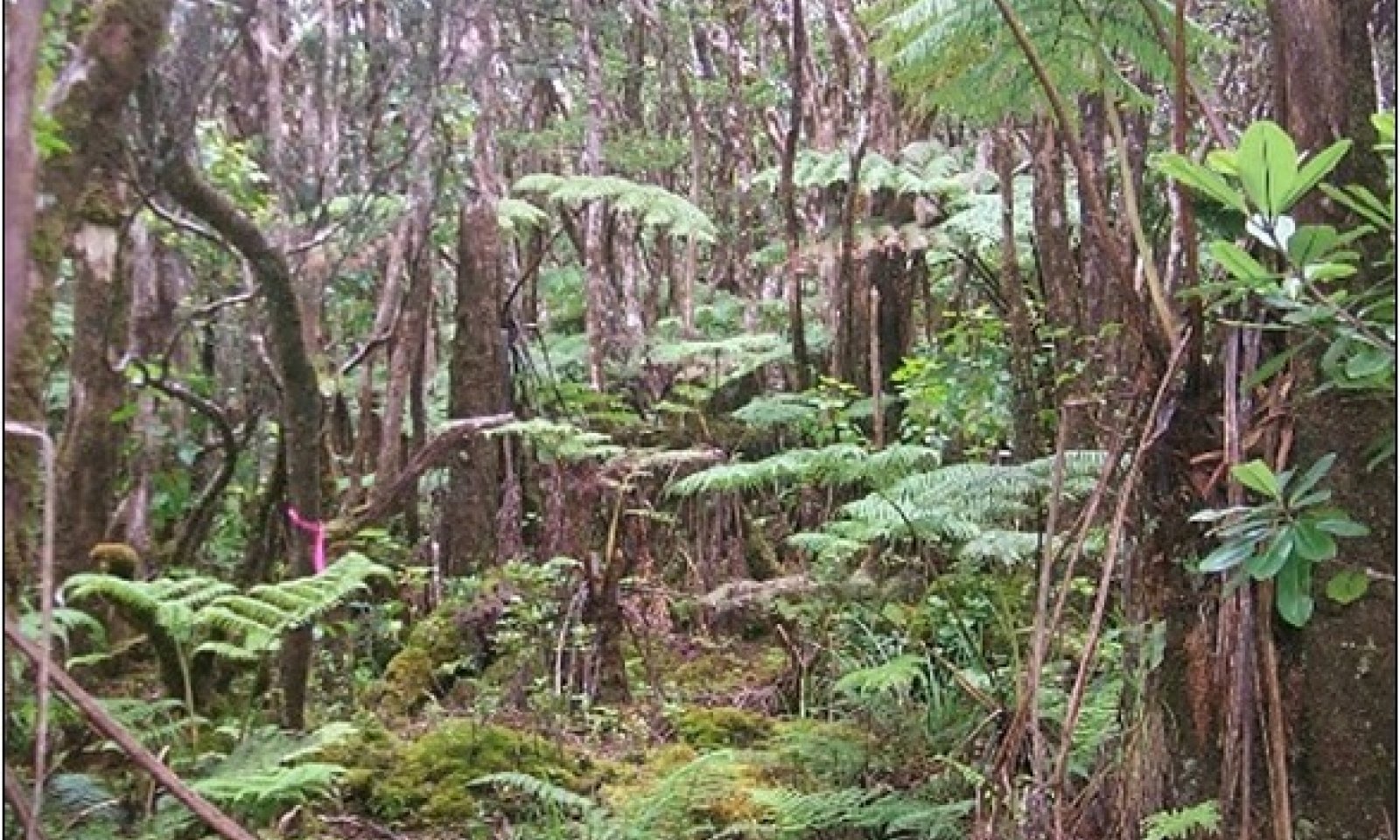
The central concept of the Volcanic Ash Forest is of somewhat poorly to poorly drained, shallow to deep soils formed in deposits of volcanic ash deposited over aa (cobbly lava flows) or pahoehoe (flat lava flows). Lava flows range from 120,000 to 500,000 years old. Annual air temperatures and rainfall create warm (isothermic), moist (udic) soil conditions. These soils support forest with an overstory of ohia lehua (Metrosideros polymorpha) from 25 to 40 feet (8 to 12 meters) tall, a secondary tree canopy of olapa (Cheirodendron trigynum) from 15 to 25 feet (5 to 8 meters) tall, a tree fern or hapuu (Cibotium spp.) canopy 10 to 20 feet (3 to 6 meters) tall, and an understory of shrubs and ferns. Many ohia lehua trees exhibit a gnarled growth form, and there is usually a thick growth of mosses, liverworts, and small ferns on tree trunks.Associated sites
VX160X01X503 Isothermic Forest
F160XY503 Isothermic Forest occurs at lower, drier elevations than F1604XY500 on Kohala volcano.
VX164X01X501 Sphagnum Peat Dwarf Forest
F164XY501 Sphagnum Peat Dwarf Forest is a dwarf forest ecological site that occurs at wetter, higher elevation areas than F164XY500. Isolated examples of F164XY501 also occur within wetter, higher elevation parts of F164XY500 on relatively level sites that develop a surface layer of sphagnum moss.
Table 1. Dominant plant species
Tree (1) Metrosideros polymorpha
(2) Cheirodendron trigynumShrub (1) Cibotium glaucum
(2) Broussaisia argutaHerbaceous Not specified
Legacy ID
F164XY500HI
Physiographic features
This ecological site occurs on volcanic ash flows deposited over lava flows on sloping mountainsides of shield volcanoes. Volcanic ash flows range from moderately deep to very deep on the underlying lava.
Table 2. Representative physiographic features
Landforms (1) Shield volcano
(2) Ash flow
Flooding duration Very brief (4 to 48 hours) Flooding frequency None to occasional Ponding duration Brief (2 to 7 days) Ponding frequency None to occasional Elevation 1600 – 5200 ft Slope 0 – 100 % Ponding depth 0 – 1 in Water table depth 2 – 60 in Aspect NE, SW Climatic features
There are no climate stations near this ecological site with complete data sets suitable for automatically filling the data boxes and charts below.
The estimates in the following text are based on modeled climate maps and incomplete and/or historic data sets from multiple stations compiled by NRCS Hawaii Soil Survey.
Average annual precipitation ranges from 70 to 120 inches (1750 to 3000 millimeters). Rainfall is well-distributed throughout the year with an enhanced rainy season from October through April, with March being the wettest month. Additional moisture is derived from condensation of fog on vegetation. Mean annual soil temperature ranges from 59 to 75 degrees F (15 to 24 degrees C). Frost free and freeze free periods are 365 days per year.Table 3 Representative climatic features
Frost-free period (average) 0 days Freeze-free period (average) 0 days Precipitation total (average) 0 in BarLineFigure 2. Monthly precipitation range
BarLineFigure 3. Monthly average minimum and maximum temperature
Figure 4. Annual precipitation pattern
Figure 5 Annual average temperature pattern
">Influencing water features
Small, deeply-incised streams are common on this site. As they do not have flood plains, they do not appreciable affect the vegetation. Small, localized bogs with very shallow surface layers of sphagnum moss occur on areas with little slope; their vegetation is generally the same as the surrounding vegetation because of their small size. <br />
<br />
Larger level areas have Amalu soils and are outliers of ecological site F164XY501 Sphagnum Peat Dwarf Forest.Soil features
The soils on nearly all the area of this ecological site formed in weathered volcanic ash deposited on aa or pahoehoe. Landscape surfaces range from 120,000 to 500,000 years old. Soil temperature regimes are isothermic. Soil moisture regimes are udic (soil moisture control section is not dry in any part for as long as 90 cumulative days in normal years).
The basaltic volcanic ash in which these soils formed varies relatively little in chemical composition (Hazlett and Hyndman 1996; Vitousek 2004). These ash soils are classified as Andisols, which have these general characteristics: ion exchange capacity that varies with pH, but mostly retaining anions such as nitrate; high phosphorus adsorption, which restricts phosphorus availability to plants; excellent physical properties (low bulk density, good friability, weak stickiness, stable soil aggregates) for cultivation, seedling emergence, and plant root growth; resistance to compaction and an ability to recover from compaction following repeated cycles of wetting and drying; and high capacity to hold water that is available to plants. These characteristics are due to the properties of the parent material, the clay-size noncrystalline materials formed by weathering, and the soil organic matter accumulated during soil formation (Shoji et al. 1993).
A thin, light gray horizon is visible in many of these soils. This horizon is formed from aeolian dust from Asia.Table 4. Representative soil features
Parent material (1) Basaltic volcanic ash – basalt
Surface texture (1) Medial silt loam
(2) Hydrous silty clay loam
Family particle size (1) Loamy
Drainage class Somewhat poorly drained to somewhat excessively drained Permeability class Moderately slow to very rapid Soil depth 20 – 60 in Surface fragment cover <=3" 0 – 40 % Surface fragment cover >3" 0 – 30 % Available water capacity
(0-40in)5 – 7 in Calcium carbonate equivalent
(0-40in)Not specified Electrical conductivity
(0-40in)0 – 2 mmhos/cm Sodium adsorption ratio
(0-40in)Not specified Soil reaction (1:1 water)
(0-40in)4 – 7.1 Subsurface fragment volume <=3"
(Depth not specified)0 – 40 % Subsurface fragment volume >3"
(Depth not specified)0 – 30 % Ecological dynamics
The information in this ecological site description (ESD), including the state-and-transition model (STM), was developed using archaeological and historical data, professional experience, and scientific studies. The information is representative of a complex set of plant communities. Not all scenarios or plants are included. Key indicator plants, animals, and ecological processes are described to inform land management decisions.
Natural Disturbances
The natural (not human-caused) disturbances most important for discussion in this ecological site are natural fires and wind throw. Natural wildfire caused by lightning is probably not a frequent disturbance in this ecological site. Wind throw of vegetation can occur during hurricanes or other high wind events.
Human Disturbances
Human-related disturbances have been much more important than natural disturbances in this ecological site since the arrival of Polynesians and, later, Europeans. This is reflected in the State and Transition Model Diagram.
Humans arrived in the Hawaiian Islands 1200 to 1500 years ago. Their population gradually increased so that by 1600 AD at least 80% of all the lands in Hawaii below about 1500 feet (roughly 500 meters) in elevation had been extensively altered by humans (Kirch 1982); some pollen core data suggest that up to 100% of lowlands may have been altered (Athens 1997). The lowest parts of this ecological site may have been part of the Hawaiian agricultural field system before the arrival of Europeans. By the time of European contact late in the 18th century, the Polynesians had developed high population densities and placed extensive areas under intensive agriculture (Cuddihy and Stone 1990).
Prehistoric native lowland forest disturbance can be attributed to clearing for agriculture by hand or by fire, introduction of new plants and animals, and wood harvesting. The higher elevations of this ecological site have relatively low soil fertility, and would have been much less affected by clearing and agriculture.
After the arrival of Europeans, documentary evidence attests to accelerated and extensive deforestation, erosion, siltation, and changes in local weather patterns (Kirch 1983) due to more intensive land use, modern tools, and introduction of more plant, animal, and microbe species.
The Polynesians introduced dogs, Pacific rats, and small pigs to the islands. Cattle, sheep, horses, goats, and larger European pigs were introduced in the final decades of the 18th century. These animals ranged free on the islands, becoming very numerous and destructive by the early decades of the 19th century. By 1851, records reported severe overstocking of pastures, lack of fences, and large numbers of feral livestock (Henke 1929).
Parts of the lower elevations of this ecological site were cleared for sugar plantations in the 19th century; these plantations were active into the late 20th century. Plantation activities caused extensive soil erosion, which is confirmed by areas of accumulation of this eroded soil at lower elevations. Also, forests at the upper boundaries of sugar plantations were affected by harvesting of firewood and intrusion of wildfires from the sugar lands into the forest.
With abandonment of the sugar plantations, kikuyugrass (Pennisetum clandestinum) and other introduced forage grasses were established for cattle raising. Kikuyugrass is a dense-growing, highly competitive species that also provides excellent forage for cattle, and it facilitated the transition of former sugar lands to grazing lands.
Through the 20th and into the 21st centuries, increases in human populations with attendant land development, as well as accelerated introduction of non-native mammals, birds, reptiles, amphibians, invertebrates, plants, and microorganisms, have brought about dramatic changes to wild ecosystems in Hawaii. This ecological site evolved without the presence of large mammals or the regular occurrence of fires. Much of the original forest area remains. However, the native plant community in many areas has been disturbed and in some places destroyed due to agriculture, urban development, establishment of exotic timber trees, domestic and feral ungulate foraging, and invasion by introduced species. Introduced plant species are capable of completely and permanently replacing native forest.
Foraging by feral cattle and pigs or forest clearing and abandonment facilitate invasion by weeds. However, introduced weeds appear able to successfully invade native stands regardless of human or ungulate disturbances. Kikuyugrass paddocks become infested with unpalatable grasses, rushes, and shrubs under conditions of improper grazing management.State and transition model
Custom diagramStandard diagram
Figure 6. State and Transition Diagram F164XY500
More interactive model formats are also available. View Interactive Models
More interactive model formats are also available. View Interactive Models
Click on state and transition labels to scroll to the respective textEcosystem states
States 1, 5 and 2 (additional transitions)
State 1 submodel, plant communities
State 2 submodel, plant communities
State 3 submodel, plant communities
State 4 submodel, plant communities
State 6 submodel, plant communities
State 1
Reference StateThe Reference State consists of one community phase. It is a forest of low to medium height overstory with a nearly closed upper canopy. The lower, drier elevations of this ecological site have largely been converted to naturalized grassland. Based on remnant stands in this zone, mosses, liverworts, and epiphytic ferns are less abundant than in higher, wetter areas. It is likely that this lower zone originally had a different species composition as it graded into the drier ecological site below.
This state can transition into State 4 Timber Plantation by clearing and planting with introduced timber species. It transitions into State 2 Invaded Understory by weed invasion, which is accelerated by disturbance from domestic and feral ungulates. It transitions to State 5 Naturalized Grassland with Remnant Trees by mechanical clearing or gradual clearing by uncontrolled grazing and browsing by ungulates, followed by establishment of forage grasses or invasion by weedy introduced grasses.Community 1.1
`Ohi`a lehua - olapa/hapu`u
Figure 7. Reference community phase. 8/24/06 D Clausnitzer generic photo

Figure 8. Reference community phase. 10/3/06 D Clausnitzer MU434

Figure 9. Reference community phase. 10/3/06 D Clausnitzer MU434

Figure 10. View of canopy from above. 8/8/16 D Clausnitzer generic photo

Figure 11. Forest-grassland boundary. 8/22/06 D Clausnitzer generic photo

Figure 12. Transition F164XY500 to F164XY501. 11/1/06 D Clausnitzer generic photo
This community phase is a forest consisting of four canopy strata: an open or closed upper canopy of ohia lehua 25 to 40 feet (8 to 12 meters) tall, a secondary canopy of mostly olapa 15 to 25 feet (4.6 to 12 meters) tall, a tree fern canopy 10 to 20 feet (3 to 6 meters) tall, and a diverse understory of shrubs and ferns. These forests have standing live timber of 250 to 1000 cubic feet per acre, with a representative value of about 500 cubic feet per acre. Combined overstory tree canopy cover of ohia and olapa varies from about 60% to 80%; tree fern cover ranges from 30% to 80%.
Koa (Acacia koa) does not occur in this ecological site.
Many ohia lehua trees branch close to the ground and have a gnarled growth form. There is usually a heavy growth of mosses, liverworts, and small ferns on tree trunks.
At the lower, drier elevations of this ecological site, much of the area has been converted to naturalized grassland. Where forests remain in this zone, mosses, liverworts, and epiphytic ferns are less abundant than in higher, wetter areas. This lower zone is where species such as papala (Charpentiera spp.), olopua (Nestegis sandwicensis), poola (Claoxylon sandwicense), papala kepau (Pisonia brunoniana), hame (Antidesma spp.), and kilioe (Embelia pacifica) would have been common in the original forest. Tree fern cover would have been somewhat less than in the higher, wetter areas.Forest overstory.The overstory consists of ohia lehua. Olapa (Cheirodendron trigynum), kawau (Ilex anomala), kolea lau nui (Myrsine lessertiana), and kopiko (Psychotria sp.) often share the canopy with ohia lehua.
Forest understory. The secondary canopy tree species is diverse. Some species that may have been more abundant in the past are now rare, such as loulu (Pritchardia lanigera and P. gordonii) and nanu (Gardenia remyi).<br /> <br /> The tertiary canopy contains small trees but is dominated by three species of hapuu or tree ferns: hapuu (Cibotium glaucum), hapuu ii or hapuu li (Cibotium menziesii), and hapuu or Chamisso’s manfern (Cibotium chamissoi). Cibotium glaucum is the most abundant, followed by C. menziesii; C. chamissoi is the least abundant.<br /> <br /> The lowest canopy stratum, which ranges in height from the ground to about 4.5 feet (1.5 meters), consists of seedlings and immature individuals of species in the taller strata, small shrub species, forbs, vines, sedges, grasses, and over 30 species of ferns and fern allies.
Table 5. Soil surface cover
Tree basal cover 0-10% Shrub/vine/liana basal cover 0% Grass/grasslike basal cover 0% Forb basal cover 0.5-1.0% Non-vascular plants 10-20% Biological crusts 0-0% Litter 80-90% Surface fragments >0.25" and <=3" 0% Surface fragments >3" 0-0% Bedrock 0% Water 0% Bare ground 0-0% Table 6. Woody ground cover
Downed wood, fine-small (<0.40" diameter; 1-hour fuels) – Downed wood, fine-medium (0.40-0.99" diameter; 10-hour fuels) – Downed wood, fine-large (1.00-2.99" diameter; 100-hour fuels) – Downed wood, coarse-small (3.00-8.99" diameter; 1,000-hour fuels) 0-1% Downed wood, coarse-large (>9.00" diameter; 10,000-hour fuels) – Tree snags** (hard***) – Tree snags** (soft***) – Tree snag count** (hard***) 0-0 per acre Tree snag count** (hard***) 0-0 per acre * Decomposition Classes: N - no or little integration with the soil surface; I - partial to nearly full integration with the soil surface.
** >10.16cm diameter at 1.3716m above ground and >1.8288m height--if less diameter OR height use applicable down wood type; for pinyon and juniper, use 0.3048m above ground.
*** Hard - tree is dead with most or all of bark intact; Soft - most of bark has sloughed off.
Table 7. Canopy structure (% cover)
Height Above Ground (ft) Tree Shrub/Vine Grass/
GrasslikeForb <0.5 0% 0% 0% 1-1% >0.5 <= 1 0% 0-1% 0-1% 3-5% >1 <= 2 1-1% 0-1% 1-1% 5-10% >2 <= 4.5 1-3% 0-1% 0-1% 0-1% >4.5 <= 13 60-75% 0-1% – – >13 <= 40 70-85% – – – >40 <= 80 – – – – >80 <= 120 – – – – >120 – – – – State 2
Invaded Understory StateThis state consists of one community phase. It arises by invasion by introduced species of intact native forest (the Reference State) or, in some cases, of native overstory stands from which the original understory has been cleared. Native species are unable to regenerate in the highly competitive understory of introduced plants and eventually die out. With time, large introduced tree species will emerge to replace the native overstory trees and form a new overstory. When this last step has occurred, the site will have transitioned to State 3 Invaded Overstory and Understory.
Disturbance of the soil and direct damage to native understory plants by introduced ungulates, particularly pigs and cattle, will speed the transition to this state by killing native plants and by creating better germination sites for introduced species.
Restoration to the Reference State or a facsimile of it is possible by fencing the site, removing all ungulates, applying herbicides, and replanting native species when needed. Restoration efforts will be affected depending on the degree of invasion by introduced species and by the particular species that have invaded the site. Long term weed management and fence maintenance will be necessary.Community 2.1
`Ohi`a lehua - strawberry guava/Kahila garland-lily (kahili ginger)
Figure 13. Invaded understory beneath ohia lehua trees. 9//11/08 D Clausnitzer generic photo

Figure 14. Invasive glenwood grass. 8/15/06 D Clausnitzer generic photo
The community has an intact or diminished overstory of ohia lehua trees with a dense understory of introduced shrubs, ferns, vines, grasses, and small trees.
Forest overstory.The overstory consists of ohia lehua (Metrosideros polymorpha). Other native species are somewhat diminished.
Forest understory. The only native species remaining in the lower canopy levels are a few native trees and some hapuu (Cibotium glaucum) and hapuu li (Cibotium menziesii). Small native fern species may be diverse but less abundant than in the Reference state.<br /> <br /> The understory is usually dominated by dense kahili ginger (Hedychium gardnerianum) and strawberry guava or waiawi (Psidium cattleianum).
Table 8. Soil surface cover
Tree basal cover 0-0% Shrub/vine/liana basal cover 0-0% Grass/grasslike basal cover 0-0% Forb basal cover 0-0% Non-vascular plants 10-20% Biological crusts 0-0% Litter 70-80% Surface fragments >0.25" and <=3" 0% Surface fragments >3" 0-0% Bedrock 0% Water 0% Bare ground 0-10% Table 9. Woody ground cover
Downed wood, fine-small (<0.40" diameter; 1-hour fuels) – Downed wood, fine-medium (0.40-0.99" diameter; 10-hour fuels) – Downed wood, fine-large (1.00-2.99" diameter; 100-hour fuels) 0-1% Downed wood, coarse-small (3.00-8.99" diameter; 1,000-hour fuels) 0-1% Downed wood, coarse-large (>9.00" diameter; 10,000-hour fuels) – Tree snags** (hard***) – Tree snags** (soft***) – Tree snag count** (hard***) 0-0 per acre Tree snag count** (hard***) 0-0 per acre * Decomposition Classes: N - no or little integration with the soil surface; I - partial to nearly full integration with the soil surface.
** >10.16cm diameter at 1.3716m above ground and >1.8288m height--if less diameter OR height use applicable down wood type; for pinyon and juniper, use 0.3048m above ground.
*** Hard - tree is dead with most or all of bark intact; Soft - most of bark has sloughed off.
Table 10. Canopy structure (% cover)
Height Above Ground (ft) Tree Shrub/Vine Grass/
GrasslikeForb <0.5 0% 0% 0% 0% >0.5 <= 1 0% 0-1% 1-2% 3-5% >1 <= 2 0-1% 3-5% 2-3% 3-5% >2 <= 4.5 3-5% 30-70% 0-1% – >4.5 <= 13 20-30% 5-10% – – >13 <= 40 50-75% – – – >40 <= 80 0-1% – – – >80 <= 120 – – – – >120 – – – – State 3
Invaded Overstory and Understory StateThis state is comprised of one plant community dominated by introduced species in both the overstory and understory. Understory vegetation usually is very sparse to nonexistent. Remnant individuals of a few native species may persist. This state might be considered a dead end as far as further succession. Mechanical clearing followed by establishment of introduced timber species would bring a transition to State 4 Timber Plantation; mechanical clearing followed by establishment of introduced forage specie would bring a transition to State 6 Naturalized Grassland.
Community 3.1
Strawberry guava
Figure 15. Dense strawberry guava stand. 11/27/06 D Clausnitzer generic photo

Figure 16. Strawberry guava stand root system exposed by bulldozer. D Clausnitzer generic photo

Figure 17. Closeup of exposed strawberry guava root system. D Clausnitzer generic photo
Strawberry guava is typically the dominant species because it invades sites by seeds spread by pigs and reproduces vegetatively by root suckers. In places, taller introduced tree species are common. It is possible that shifts will eventually occur in the introduced species that dominate a site, particularly if tall stature, competitive tree species are present. This would not represent a transition to another state. Sites that are completely dominated by dense stands of strawberry guava typically show no indications (death or partial death of stands; emergence of potentially taller tree species) of yielding to change in the foreseeable future.
Forest overstory.A few remnant ohia lehua (Metrosideros polymorpha) trees often remain as emergents above the canopy of introduced species, but no seedlings or saplings are likely to be present. Depending on local seed sources, strawberry guava (Psidium cattleianum) generally will become dominant over time. Taller statured introduced trees including silkoak (Grevillea robusta), albizia or peacocksplume (Falcataria moluccana), tropical ash (Fraxinus uhdei), and paperbark (Melaleuca quinquinervia) are dominant on some sites.
Forest understory. Kahili ginger or Kahila garland-lily (Hedychium gardnerianum) forms an extremely dense understory on many sites that do not have a closed strawberry guava overstory. Scattered individuals of native species such as hapuu (Cibotium glaucum) and uluhe (Dicranopteris linearis) may remain in the understory.
Table 11. Soil surface cover
Tree basal cover 0-0% Shrub/vine/liana basal cover 0% Grass/grasslike basal cover 0% Forb basal cover 0-0% Non-vascular plants 10-20% Biological crusts 0% Litter 70-80% Surface fragments >0.25" and <=3" 0% Surface fragments >3" 0-0% Bedrock 0% Water 0% Bare ground 0-10% Table 12. Woody ground cover
Downed wood, fine-small (<0.40" diameter; 1-hour fuels) – Downed wood, fine-medium (0.40-0.99" diameter; 10-hour fuels) – Downed wood, fine-large (1.00-2.99" diameter; 100-hour fuels) – Downed wood, coarse-small (3.00-8.99" diameter; 1,000-hour fuels) 0-1% Downed wood, coarse-large (>9.00" diameter; 10,000-hour fuels) – Tree snags** (hard***) – Tree snags** (soft***) – Tree snag count** (hard***) 0-0 per acre Tree snag count** (hard***) 0-0 per acre * Decomposition Classes: N - no or little integration with the soil surface; I - partial to nearly full integration with the soil surface.
** >10.16cm diameter at 1.3716m above ground and >1.8288m height--if less diameter OR height use applicable down wood type; for pinyon and juniper, use 0.3048m above ground.
*** Hard - tree is dead with most or all of bark intact; Soft - most of bark has sloughed off.
Table 13. Canopy structure (% cover)
Height Above Ground (ft) Tree Shrub/Vine Grass/
GrasslikeForb <0.5 0% 0% 0% 0% >0.5 <= 1 0% 0% 0-1% 0-1% >1 <= 2 1-1% 0% 1-1% 1-2% >2 <= 4.5 5-10% 1-2% 1-1% 15-25% >4.5 <= 13 45-55% – – – >13 <= 40 25-35% – – – >40 <= 80 0-1% – – – >80 <= 120 – – – – >120 – – – – State 4
Timber Plantation StateThis state consists of one community phase, which is a plantation of introduced timber tree species that have been established on forest or grazing lands. With proper management, it is not susceptible to unplanned transitions or restorations to other states.
Community 4.1
Exotic timber species/strawberry guava/Kahila garland-lily (kahili ginger)
Figure 18. Dense kahili ginger under planted exotic timber trees. 11/8/06 D Clausnitzer generic photo
This community is typically managed in the long term for economic returns. Many introduced timber species will potentially grow well in the environment of this ecological site, where they also may be free of pests that are present in their native habitats.
Forest overstory.Tree species that have been planted in the past are albizia or peacocksplume (Falcataria moluccana), redwood (Sequoia sempervirens), eucalyptus (Eucalyptus spp.), Nepal alder (Alnus nepalensis), and tropical ash (Fraxinus uhdei). Weeds from seed sources surrounding these sites or brought in unintentionally by humans and animals have invaded these sites and now dominate the understory where ongoing weed control has not been practiced. Other species may also be suitable.
Forest understory. The most common understory weeds are strawberry guava (Psidium cattleianum) and kahili ginger (Hedychium gardnerianum).
Table 14. Soil surface cover
Tree basal cover 0-10% Shrub/vine/liana basal cover 0% Grass/grasslike basal cover 0-0% Forb basal cover 0-0% Non-vascular plants 10-10% Biological crusts 0% Litter 70-80% Surface fragments >0.25" and <=3" 0% Surface fragments >3" 0-0% Bedrock 0% Water 0% Bare ground 10-10% Table 15. Woody ground cover
Downed wood, fine-small (<0.40" diameter; 1-hour fuels) – Downed wood, fine-medium (0.40-0.99" diameter; 10-hour fuels) – Downed wood, fine-large (1.00-2.99" diameter; 100-hour fuels) – Downed wood, coarse-small (3.00-8.99" diameter; 1,000-hour fuels) 2-3% Downed wood, coarse-large (>9.00" diameter; 10,000-hour fuels) 2-3% Tree snags** (hard***) – Tree snags** (soft***) – Tree snag count** (hard***) 0-0 per acre Tree snag count** (hard***) 0-0 per acre * Decomposition Classes: N - no or little integration with the soil surface; I - partial to nearly full integration with the soil surface.
** >10.16cm diameter at 1.3716m above ground and >1.8288m height--if less diameter OR height use applicable down wood type; for pinyon and juniper, use 0.3048m above ground.
*** Hard - tree is dead with most or all of bark intact; Soft - most of bark has sloughed off.
Table 16. Canopy structure (% cover)
Height Above Ground (ft) Tree Shrub/Vine Grass/
GrasslikeForb <0.5 0% 0% 0% 0% >0.5 <= 1 0% 0-1% 3-5% 0% >1 <= 2 1-1% 1-1% 1-2% 1-1% >2 <= 4.5 3-5% 1-1% – 25-35% >4.5 <= 13 15-25% – – – >13 <= 40 5-10% – – – >40 <= 80 75-85% – – – >80 <= 120 – – – – >120 – – – – State 5
Naturalized Grassland with Remnant Trees StateThis state consists of three grassland community phases that have an open canopy of native trees. These phases are maintained by grazing, which keeps preferred species from becoming too rank, and adequate recovery periods, which ensure vigor and cover of preferred species. High production of preferred grass species and extensive cover allow for increased soil moisture retention, vegetative production, and overall soil quality. These factors are degraded by grazing practices that result in loss of preferred grass species leading to increase in less desirable grasses, weed invasion, and an increase in the extent of bare soil.
Community phase 5.1, when subjected to continuous grazing that does not allow the preferred forage species to recover from defoliation, shifts to Community phase 5.2, which is dominated by lower value grass species but contains enough cover of preferred forages to allow for a shift back to Phase 5.1 with prescribed grazing. Longer-term continuous grazing leads to Community Phase 5.3, which consists of low value grass species and increasing cover of weedy shrubs and tree saplings. Improvement of this phase requires weed control followed by prescribed grazing.Community 5.1
`Ohi`a lehua/kikuyugrass/common vetch
Figure 19. Grassland with ohia lehua. 1/14/08 D Clausnitzer generic photo
Canopy cover of overstory trees typically is about 25 to 40 percent. Trees provide shade and protection from the elements to livestock. However, little or no regeneration of trees occurs, so the overstory will eventually die out.
Forest overstory.The open overstory consists mostly of ohia lehua (Metrosideros polymorpha).
Forest understory. A few olapa (Cheirodendron trigynum) and hapuu (Cibotium glaucum) may be present. Kikuyugrass (Pennisetum clandestinum) is the most common preferred forage grass. Pangolagrass (Digitaria eriantha) has been established on some sites. The most common legumes are common vetch (Vicia sativa), white clover (Trifolium repens), and Greenleaf desmodium (Desmodium intortum).
Figure 20. Annual production by plant type (representative values) or group (midpoint values)
Community 5.2
`Ohi`a lehua/kikuyugrass/broomsedge bluestem
Figure 21. Broomsedge bluestem. 11/28/06 D Clausnitzer MU434
This community phase is dominated by grass and grasslike species with lower forage value than kikuyugrass and pangolagrass. Cover of preferred forage grasses is still high enough to enable a shift back to phase 5.1 with improved management. Cattle can be maintained on the lower value forages, but animal growth and vigor will be reduced. Also, the number of weedy species is high, and their stature, seed production potential, and wide distribution can lead to rapid increase and a shift to Community Phase 5.3 unless management is improved.
Forest overstory.The open overstory consists mostly of ohia lehua (Metrosideros polymorpha). Some strawberry guava (Psidium cattleianum) and common guava (Psidium guajava) may have grown into the overstory.
Forest understory. Cover of kikuyugrass (Pennisetum clandestinum) and/or pangolagrass (Digitaria eriantha) ranges about 40 to 60 percent. Weedy broomsedge bluestem (Andropogon virginicus) and common rush (Juncus effusus) may have increased to 10 percent cover or more. Desirable legumes have become very rare.
Table 17. Soil surface cover
Tree basal cover 0-0% Shrub/vine/liana basal cover 0% Grass/grasslike basal cover 20-30% Forb basal cover 0.0-0.5% Non-vascular plants 0-10% Biological crusts 0% Litter 60-70% Surface fragments >0.25" and <=3" 0% Surface fragments >3" 0-0% Bedrock 0% Water 0% Bare ground 0-10% Table 18. Woody ground cover
Downed wood, fine-small (<0.40" diameter; 1-hour fuels) – Downed wood, fine-medium (0.40-0.99" diameter; 10-hour fuels) – Downed wood, fine-large (1.00-2.99" diameter; 100-hour fuels) – Downed wood, coarse-small (3.00-8.99" diameter; 1,000-hour fuels) 0% Downed wood, coarse-large (>9.00" diameter; 10,000-hour fuels) – Tree snags** (hard***) – Tree snags** (soft***) – Tree snag count** (hard***) 0-0 per acre Tree snag count** (hard***) 0-0 per acre * Decomposition Classes: N - no or little integration with the soil surface; I - partial to nearly full integration with the soil surface.
** >10.16cm diameter at 1.3716m above ground and >1.8288m height--if less diameter OR height use applicable down wood type; for pinyon and juniper, use 0.3048m above ground.
*** Hard - tree is dead with most or all of bark intact; Soft - most of bark has sloughed off.
Table 19. Canopy structure (% cover)
Height Above Ground (ft) Tree Shrub/Vine Grass/
GrasslikeForb <0.5 0% 0% 0% 3-5% >0.5 <= 1 0% 0-1% 10-20% 3-5% >1 <= 2 0% 0-1% 50-60% 1-2% >2 <= 4.5 1-1% 1-2% 10-30% – >4.5 <= 13 1-2% – – – >13 <= 40 2-20% – – – >40 <= 80 1-10% – – – >80 <= 120 – – – – >120 – – – – Community 5.3
`Ohi`a lehua/common rush - broomsedge bluestem
Figure 22. Heavily grazed grassland with common rush. 9/26/07 D Clausnitzer generic photo

Figure 23. Heavily grazed site. 9/26/07 D Clausnitzer generic photo
This community phase is dominated by low value grasses, forbs, shrubs, and small trees. Improving the grazing regime is extremely unlikely to shift this phase to a more productive grassland phase due to the low cover of desirable species and the abundance of weeds. Frequent mowing is not worthwhile; it will keep shrubs and trees in check but will do little to improve the grass and forb community. Herbicide treatments are needed to reduce weed abundance. Resprigging of desired grass forage species may be needed, along with removal of livestock until desired species have reassumed dominance. There typically is a high population of stunted weedy trees and shrubs that is suppressed by heavy grazing and is poised to explode if grazing pressure is reduced or removed.
Forest overstory.The open overstory consists mostly of ohia lehua (Metrosideros polymorpha). Some strawberry guava (Psidium cattleianum) and common guava (Psidium guajava) may have grown into the overstory.
Forest understory. Cover of desirable grass species is about 20% or less. Common rush (Juncus effusus) is abundant, particularly in wetter spots. Broomsedge bluestem (Andropogon virginicus) is the most common grass species. A large variety of weedy forbs is present. Strawberry guava (Psidium cattleianum) and common guava (Psidium guajava) may be more abundant than they appear, because cattle have browsed their stems almost to ground level. If browsing stops, these species will rapidly take over a site. Thimbleberry (Rubus rosifolius) and yellow Himalayan raspberry (Rubus sawtooth blackberry) form scattered thickets.
Table 20. Soil surface cover
Tree basal cover 0-0% Shrub/vine/liana basal cover 0% Grass/grasslike basal cover 30-30% Forb basal cover 0.0-0.5% Non-vascular plants 0-10% Biological crusts 0% Litter 60-70% Surface fragments >0.25" and <=3" 0% Surface fragments >3" 0-0% Bedrock 0% Water 0% Bare ground 0-10% Table 21. Woody ground cover
Downed wood, fine-small (<0.40" diameter; 1-hour fuels) – Downed wood, fine-medium (0.40-0.99" diameter; 10-hour fuels) – Downed wood, fine-large (1.00-2.99" diameter; 100-hour fuels) – Downed wood, coarse-small (3.00-8.99" diameter; 1,000-hour fuels) 0% Downed wood, coarse-large (>9.00" diameter; 10,000-hour fuels) 0% Tree snags** (hard***) – Tree snags** (soft***) – Tree snag count** (hard***) 0-0 per acre Tree snag count** (hard***) 0-0 per acre * Decomposition Classes: N - no or little integration with the soil surface; I - partial to nearly full integration with the soil surface.
** >10.16cm diameter at 1.3716m above ground and >1.8288m height--if less diameter OR height use applicable down wood type; for pinyon and juniper, use 0.3048m above ground.
*** Hard - tree is dead with most or all of bark intact; Soft - most of bark has sloughed off.
Table 22. Canopy structure (% cover)
Height Above Ground (ft) Tree Shrub/Vine Grass/
GrasslikeForb <0.5 0% 0% 1-2% 1-5% >0.5 <= 1 0% 0-1% 10-20% 2-3% >1 <= 2 0% 1-1% 30-40% 5-10% >2 <= 4.5 0-1% 1-1% 20-30% 3-5% >4.5 <= 13 1-1% – – – >13 <= 40 5-25% – – – >40 <= 80 0-1% – – – >80 <= 120 – – – – >120 – – – – Pathway 5.1A
Community 5.1 to 5.2
`Ohi`a lehua/kikuyugrass/common vetch
`Ohi`a lehua/kikuyugrass/broomsedge bluestemThis community phase degrades to Phase 5.2 by continuous grazing that weakens preferred kikuyugrass, pangolagrass, and legumes in relation to less desirable forage species such as hilograss, narrowleaf carpetgrass, and Japanese mat rush.
Pathway 5.2B
Community 5.2 to 5.1
`Ohi`a lehua/kikuyugrass/broomsedge bluestem
`Ohi`a lehua/kikuyugrass/common vetchCommunity phase 5.2 degrades to phase 5.3 by long-term continuous grazing that reduces cover and competitiveness of kikuyugrass and pangolagrass. The grassland becomes dominated by inedible Japanese mat rush and/or broomsedge along with shorter undesirable grasses such as hilograss, narrowleaf carpetgrass, and yellow foxtail. There may be a large population of undesirable weedy shrubs and trees that is kept in check by heavy grazing pressure.
Pathway 5.2A
Community 5.2 to 5.3
`Ohi`a lehua/kikuyugrass/broomsedge bluestem
`Ohi`a lehua/common rush - broomsedge bluestemCommunity phase 5.2 can be reconverted to phase 5.1 by prescribed grazing. A prescribed grazing plan provides for intensive but temporary grazing of grasslands that ensures that cattle consume some low-value forage species along with preferred forages and allows preferred forages time to recover from defoliation. The grazing plan may require splitting the herd, creating additional water sources, and creating multiple pastures by cross-fencing. Invading broomsedge bluestem may be controlled by mowing their seed stalks before seed set and by liming to increase soil pH.
Pathway 5.3A
Community 5.3 to 5.2
`Ohi`a lehua/common rush - broomsedge bluestem
`Ohi`a lehua/kikuyugrass/broomsedge bluestemHerbicidal weed control measures, liming, and mechanical brush control can reduce the densities of weedy shrubs, forbs, and grasses and allow implementation of prescribed grazing.
State 6
Naturalized Grassland StateThis state consists of three grassland community phases with little or no tree overstory. These phases are maintained by grazing, which keeps preferred species from becoming too tall, and adequate recovery periods, which ensure vigor and cover of preferred species. High production of preferred grass species and extensive cover allow for increased soil moisture retention, vegetative production, and overall soil quality. These factors are degraded by grazing practices that result in loss of preferred grass species leading to increase in less desirable grasses, weed invasion, and an increase in the extent of bare soil.
Community phase 6.1, when subjected to continuous grazing that does not allow the preferred forage species to recover from defoliation, shifts to Community phase 6.2, which is dominated by lower value grass species but contains enough cover of preferred forages to allow for a shift back to Phase 6.1 with prescribed grazing. Longer-term continuous grazing leads to Community Phase 6.3, which consists of low value grass species and increasing cover of weedy shrubs and tree saplings. Improvement of this phase requires weed control followed by prescribed grazing.Community 6.1
Kikuyugrass/common vetch
Figure 24. Naturalized kikuyu grassland. 1/14/08 D Clausnitzer generic photo

Figure 25. Pangola (l)/carpetgrass (r) fenceline. 8/19/08 D Clausnitzer generic photo
Tree overstory is nonexistent or present with a canopy cover less than 25 percent.
Forest overstory.Where present, the overstory consists mostly of ohia lehua (Metrosideros polymorpha).
Forest understory. Kikuyugrass (Pennisetum clandestinum) is the most common preferred forage grass. Pangolagrass (Digitaria eriantha) has been established on some sites. The most common legumes are common vetch (Vicia sativa), white clover (Trifolium repens), and Greenleaf desmodium (Desmodium intortum).
Figure 26. Annual production by plant type (representative values) or group (midpoint values)
Community 6.2
Kikuyugrass - broomsedge bluestem
Figure 27. Broomsedge bluestem. 11/18/06 D Clausnitzer generic photo
This community phase is dominated by grass and grasslike species with lower forage value than kikuyugrass and pangolagrass. Cover of preferred forage grasses is still high enough to enable a shift back to phase 6.1 with improved management. Cattle can be maintained on the lower value forages, but animal growth and vigor will be reduced. Also, the number of weedy species is high, and their stature, seed production potential, and wide distribution can lead to rapid increase and a shift to Community Phase 6.3 unless management is improved.
Forest overstory.Where present, the overstory consists mostly of ohia lehua (Metrosideros polymorpha). Some strawberry guava (Psidium cattleianum) and common guava (Psidium guajava) may have grown into the overstory.
Forest understory. Cover of kikuyugrass (Pennisetum clandestinum) and/or pangolagrass (Digitaria eriantha) ranges about 40 to 60 percent. Weedy broomsedge bluestem (Andropogon virginicus) and common rush (Juncus effusus) may have increased to 10 percent cover or more. Desirable legumes have become very rare
Table 23. Soil surface cover
Tree basal cover 0% Shrub/vine/liana basal cover 0% Grass/grasslike basal cover 30-40% Forb basal cover 0.0-0.5% Non-vascular plants 0-0% Biological crusts 0% Litter 60-70% Surface fragments >0.25" and <=3" 0% Surface fragments >3" 0-0% Bedrock 0% Water 0% Bare ground 0-10% Table 24. Canopy structure (% cover)
Height Above Ground (ft) Tree Shrub/Vine Grass/
GrasslikeForb <0.5 0% 0% 3-5% 3-5% >0.5 <= 1 0% 0% 30-40% 3-5% >1 <= 2 0% 0% 30-40% 1-2% >2 <= 4.5 0-1% 0-1% 5-10% 3-5% >4.5 <= 13 1-2% – – – >13 <= 40 – – – – >40 <= 80 – – – – >80 <= 120 – – – – >120 – – – – Community 6.3
Common rush - broomsedge bluestem
Figure 28. Heavily grazed site. 9/26/07 D Clausnitzer generic photo
This community phase is dominated by low value grasses, forbs, shrubs, and small trees. Improving the grazing regime is extremely unlikely to shift this phase to a more productive grassland phase due to the low cover of desirable species and the abundance of weeds. Frequent mowing is not worthwhile; it will keep shrubs and trees in check but will do little to improve the grass and forb community. Herbicide treatments are needed to reduce weed abundance. Resprigging of desired grass forage species may be needed, along with removal of livestock until desired species have reassumed dominance. There typically is a high population of stunted weedy trees and shrubs that is suppressed by heavy grazing and is poised to explode if grazing pressure is reduced or removed.
Forest overstory.Where present, the overstory consists mostly of ohia lehua (Metrosideros polymorpha). Some strawberry guava (Psidium cattleianum) and common guava (Psidium guajava) may have grown into the overstory.
Forest understory. Cover of desirable grass species is about 20% or less. Common rush (Juncus effusus) is abundant, particularly in wetter spots. Broomsedge bluestem (Andropogon virginicus) is the most common grass species. A large variety of weedy forbs is present. Strawberry guava (Psidium cattleianum) and common guava (Psidium guajava) may be more abundant than they appear, because cattle have browsed their stems almost to ground level. If browsing stops, these species will rapidly take over a site. Thimbleberry (Rubus rosifolius) and yellow Himalayan raspberry (Rubus sawtooth blackberry) form scattered thickets.
Table 25. Soil surface cover
Tree basal cover 0% Shrub/vine/liana basal cover 0% Grass/grasslike basal cover 30-40% Forb basal cover 0.0-0.5% Non-vascular plants 0-0% Biological crusts 0% Litter 60-70% Surface fragments >0.25" and <=3" 0% Surface fragments >3" 0-0% Bedrock 0% Water 0% Bare ground 0-10% Table 26. Canopy structure (% cover)
Height Above Ground (ft) Tree Shrub/Vine Grass/
GrasslikeForb <0.5 0% 0% 3-5% 3-5% >0.5 <= 1 0% 0% 10-20% 1-2% >1 <= 2 0% 0% 40-50% 3-5% >2 <= 4.5 1-1% 1-2% 15-25% – >4.5 <= 13 1-1% – – – >13 <= 40 – – – – >40 <= 80 – – – – >80 <= 120 – – – – >120 – – – – Pathway 6.1A
Community 6.1 to 6.2
Kikuyugrass/common vetch
Kikuyugrass - broomsedge bluestemThis community phase degrades to Phase 6.2 by continuous grazing that weakens preferred kikuyugrass, pangolagrass, and legumes in relation to less desirable forage species such as hilograss, narrowleaf carpetgrass, and Japanese mat rush.
Pathway 6.2B
Community 6.2 to 6.1
Kikuyugrass - broomsedge bluestem
Kikuyugrass/common vetchCommunity phase 6.2 degrades to phase 6.3 by long-term continuous grazing that reduces cover and competitiveness of kikuyugrass and pangolagrass. The grassland becomes dominated by inedible Japanese mat rush and/or broomsedge along with shorter undesirable grasses such as hilograss, narrowleaf carpetgrass, and yellow foxtail. There may be a large population of undesirable weedy shrubs and trees that is kept in check by heavy grazing pressure.
Pathway 6.2A
Community 6.2 to 6.3
Kikuyugrass - broomsedge bluestem
Common rush - broomsedge bluestemCommunity phase 6.2 can be converted to phase 6.1 by prescribed grazing. A prescribed grazing plan provides for intensive but temporary grazing of grasslands that ensures that cattle consume some low-value forage species along with preferred forages and allows preferred forages time to recover from defoliation. The grazing plan may require splitting the herd, creating additional water sources, and creating multiple pastures by cross-fencing. Invading broomsedge bluestem may be controlled by mowing their seed stalks before seed set and by liming to increase soil pH.
Pathway 6.3A
Community 6.3 to 6.2
Common rush - broomsedge bluestem
Kikuyugrass - broomsedge bluestemHerbicidal weed control measures, liming, and mechanical brush control can reduce the densities of weedy shrubs, forbs, and grasses and allow implementation of prescribed grazing.
Transition T1A
State 1 to 2State 1, Reference State, can transition to State 2 Invaded Understory, by gradual replacement of the native understory by introduced shrubs, vines, and small trees that outcompete the native understory species. This process is accelerated by ungulate foraging that disturbs the soil surface and directly destroys native plants and prevents their regeneration.
Transition T1B
State 1 to 4This state transitions to State 4 Timber Plantation Understory by mechanical removal of the original forest overstory and understory followed by planting of introduced timber species. Introduced weeds will invade and take over the unless controlled by herbicides.
Transition T1C
State 1 to 5This state will transition to State 5 Naturalized Grassland with Remnant trees by clearing the forest with heavy machinery or by gradual clearing by allowing domestic or feral cattle access to the forest. Cattle eventually eat or destroy understory ferns, forbs, shrubs, and saplings, opening up the forest so that grasses will thrive. Desired forages such as kikuyugrass may then be established, or undesirable grass and rush species will establish on their own.
Restoration pathway R2A
State 2 to 1It is possible to restore a facsimile of State 1 Reference State from State 2 Invaded Understory. Before restoration of native plants, introduced understory plants must be eliminated by herbicidal weed control practices, and ungulates must be excluded from the restoration site by a suitable fence. Native species that have been eliminated or greatly reduced in numbers must be restored by replanting. Biodegradable mulch such as cardboard covered with plant litter is very useful for weed control around replanted native species. Long-term control of weeds will be necessary.
Transition T2A
State 2 to 3The large native ohia lehua and other tree species that form the overstory of State 2 Invaded Understory are unable to successfully regenerate due to the dense, shady understory of introduced species. Eventually the large native trees die and are replaced by introduced tree species.
Transition T2B
State 2 to 4This state transitions to State 4 Timber Plantation by mechanical removal of the forest overstory and understory followed by planting of introduced timber species. Introduced understory weeds will reestablish unless controlled by herbicides.
Transition T2C
State 2 to 5This state may be restored to State 5 Naturalized Grassland with Remnant Trees by mechanical clearing. Introduced forage grasses may then be seeded or sprigged into the site. Herbicide applications will be necessary before and during pasture establishment to control reemerging weed species.
Transition T3A
State 3 to 4This state may transition to State 4 Timber Plantation by mechanical land clearing followed by establishment of introduced timber trees. A weedy understory will reestablish itself unless weed control is maintained.
Restoration pathway R3A
State 3 to 6This state may be restored to State 6 Naturalized Grassland by mechanical clearing of overstory and understory vegetation. Introduced forage grasses may then be seeded or sprigged into the site. Herbicide applications will be necessary before and during forage establishment to control reemerging weed species.
Restoration pathway R5A
State 5 to 1It is possible to restore this state to a facsimile of the Reference State. Weed control must be applied to grasses species and the many opportunistic plant species that invade the site. Weed control is be a perpetual process to capture and maintain the site. Foraging by domestic and feral ungulates must be eliminated by excluding all ungulates from the restoration site, but domestic ungulates would be useful to initially reduce grass cover and afterward to manage vegetation outside the restoration site perimeter. Extensive planting of native species would follow. Biodegradable mulch such as cardboard covered with plant litter is very useful.
Restoration pathway R5B
State 5 to 2Abandonment of this state, including removal of livestock, results in rapid invasion of weedy forbs, shrubs, trees, and ferns that converts the site to State 2 Invaded Understory. However, presence of large numbers of feral cattle can maintain the site as State 5, Community Phase 5.3.
Transition T5A
State 5 to 6Native overstory species are unable regenerate in this plant community due to grazing, browsing, and trampling by ungulates, as well as competition from both desired forages and weeds. The overstory eventually dies out, resulting in treeless grassland.
Transition T6A
State 6 to 3This state will transition to State 3 Invaded Overstory and Understory by abandonment, including removal of domestic cattle. However, if large numbers of feral cattle are present, the site will remain in State 6, Community Phase 6.3.
Restoration pathway R6A
State 6 to 5Restoring an open overstory of native ohia lehuas to this plant community with the goal of eventual restoration to State 1 Reference would be a difficult process. Ungulate exclusion would allow rapid growth of grasses and invading weeds that would have to be controlled by herbicides. If ungulates were not excluded, planting of native species would have to be done in small exclosures.
Additional community tables
Table 27. Community 1.1 plant community composition
Group Common name Symbol Scientific name Annual production () Foliar cover (%) Table 28. Community 1.1 forest overstory composition
Common name Symbol Scientific name Nativity Height ft Canopy cover (%) Diameter in Basal area (square ft/acre) Tree'ohi'a lehua MEPO5 Metrosideros polymorpha Native 40-60 0-80 12-15 0 'ohi'a lehua MEPO5 Metrosideros polymorpha Native 13-40 60-80 6-12 0 olapalapa CHTR2 Cheirodendron trigynum Native 13-30 5-10 – 0 wild coffee PSYCH Psychotria Native 13-25 0.5-1 – 0 kolea lau nui MYLE2 Myrsine lessertiana Native 13-25 0.5-1 – 0 lo'ulu PRLA4 Pritchardia lanigera Native 13-40 0-0.5 – 0 Hawai'i cheesewood PIHA4 Pittosporum hawaiiense Native 13-25 0-0.5 – 0 Hawai'i olive NESA2 Nestegis sandwicensis Native 13-16 0 – 0 hopue URGL Urera glabra Native 13-20 0 – 0 Australasian catchbirdtree PIBR3 Pisonia brunoniana Native 13-20 0 – 0 Remy's gardenia GARE Gardenia remyi Native 13-20 0 – 0 tetraplasandra TETRA11 Tetraplasandra Native 13-30 0 – 0 Tree Fernhapu'u CIGL Cibotium glaucum Native 13-20 0-10 – 0 hapu'u li CIME8 Cibotium menziesii Native 13-20 0-2 – 0 Chamisso's manfern CICH Cibotium chamissoi Native 13-20 0 – 0 Table 29. Community 1.1 forest understory composition
Common name Symbol Scientific name Nativity Height (ft) Canopy cover (%) Grass/grass-like (Graminoids)Hawai'i sedge CAAL12 Carex alligata Native 1–2 0–1 Hawai'i birdcatching sedge UNUN Uncinia uncinata Native 0.5–1 0–0.5 Hawai'i woodrush LUHA2 Luzula hawaiiensis Native 0.5–1 0–0.5 Oahu flatsedge CYHY2 Cyperus hypochlorus Native 1–2 0–0.5 manyspike flatsedge CYPO Cyperus polystachyos Native 1–2 0 ridgetop bloodgrass ISDI Isachne distichophylla Native 1–2 0 Forb/Herbpeperomia PEPER Peperomia Native 0.5–1 0.5–1 pua'akuhinia ASME4 Astelia menziesiana Native 0.5–1 0.5–1 Fern/fern allyalpine woodfern DRWA Dryopteris wallichiana Native 1–2 1–5 palapalai MIST4 Microlepia strigosa Native 1–2 0.5–1 spleenwort ASPLE Asplenium Native 1–2 0–1 royal tonguefern ELCR2 Elaphoglossum crassifolium Native 0.5–1 0.5–1 ekaha ELHI3 Elaphoglossum hirtum Native 0.5–1 0.5–1 Hawai'i air fern PNSA Pneumatopteris sandwicensis Native 1–2 0.5–1 ama'u SAPA11 Sadleria pallida Native 2–3 0–1 longleaf plume fern SASO2 Sadleria souleyetiana Native 2–3 0–1 Chinese creepingfern ODCH Odontosoria chinensis Native 1–2 0–1 akolea ATMI Athyrium microphyllum Native 1–2 0.5–1 Old World forkedfern DILI Dicranopteris linearis Native 1–3 0–1 Hawai'i umbrella fern STOW Sticherus owhyensis Native 1–3 0–1 graceful kihifern ADPI Adenophorus pinnatifidus Native 0.5–1 0.5–1 wahini noho mauna ADTA Adenophorus tamariscinus Native 0.2–0.5 0–1 narrow swordfern NECO3 Nephrolepis cordifolia Native 1–2 0–1 Boston swordfern NEEX Nephrolepis exaltata Native 1–2 0–1 Hawai'i twinsorus fern DISA3 Diplazium sandwichianum Native 2–3 0.5–1 kilaw DRGL3 Dryopteris glabra Native 1–2 0–1 weeping fern LETH6 Lepisorus thunbergianus Native 0.5–1 0–0.5 ohiaku HYRE Hymenophyllum recurvum Native 0.1–0.2 0–0.5 vandenboschia VANDE Vandenboschia Native 0.5–1 0–0.5 Old World adderstongue OPPEP Ophioglossum pendulum ssp. pendulum Native 0.5–1 0–0.5 daggerleaf clubmoss HUPH Huperzia phyllantha Native 0.5–1 0–0.5 staghorn clubmoss LYCE2 Lycopodiella cernua Native 0.5–1 0–0.5 flatfork fern PSCO3 Psilotum complanatum Native 0.5–1 0–0.5 whisk fern PSNU Psilotum nudum Native 0.5–1 0–0.5 kolokolo GRTE Grammitis tenella Native 0.2–0.5 0–0.5 dotted polypody POPE5 Polypodium pellucidum Native 0.5–1 0 western brackenfern PTAQ Pteridium aquilinum Native 1–2 0 Cretan brake PTCR2 Pteris cretica Native 0.5–1 0 scrambling fern DIPI3 Diplopterygium pinnatum Native 1–3 0 Shrub/Subshrubohelo kau la'au VACA8 Vaccinium calycinum Native 2–5 1–2 pukiawe STTA Styphelia tameiameiae Native 2–4 0.5–1 Maui mirrorplant COOC3 Coprosma ochracea Native 2–8 0.5–1 kokea lau li'i MYSA2 Myrsine sandwicensis Native 2–10 0.5–1 pubescent mirrorplant COPU8 Coprosma pubens Native 2–8 0.5–1 kanawao BRAR6 Broussaisia arguta – 2–4 0–1 bog labordia LAHE2 Labordia hedyosmifolia Native 2–5 0.5–1 Waipio Valley clermontia CLKO Clermontia kohalae Native 2–8 0–0.5 smallflower clermontia CLPA8 Clermontia parviflora Native 2–8 0–0.5 swampforest clermontia CLWA2 Clermontia waimeae Native 2–8 0–0.5 lava clermontia CLCA5 Clermontia calophylla Native 2–8 0–0.5 Waimea pipturus PIAL2 Pipturus albidus Native 2–10 0 kanawao ke'oke'o CYPA12 Cyrtandra paludosa Native 2–3 0 largeflower false lobelia TRGR8 Trematolobelia grandifolia Native 2–8 0 koli'i TRMA8 Trematolobelia macrostachys Native 2–8 0 hairy cyanea CYPI4 Cyanea pilosa Native 2–8 0 anini EUSA6 Eurya sandwicensis Native 2–3 0 plantainleaf dubautia DUPL Dubautia plantaginea Native 2–8 0 Tree'ohi'a lehua MEPO5 Metrosideros polymorpha Native 2–13 1–2 kolea lau nui MYLE2 Myrsine lessertiana Native 2–13 1–2 wild coffee PSYCH Psychotria Native 2–13 0.5–1 olapalapa CHTR2 Cheirodendron trigynum Native 2–13 0.5–1 Hawai'i holly ILAN Ilex anomala Native 2–13 0.5–1 manono HEHI8 Hedyotis hillebrandii Native 2–5 0.5–1 variable starviolet HETE21 Hedyotis terminalis Native 2–5 0.5–1 kukaemoa MECL Melicope clusiifolia Native 2–10 0.5–1 ha'a ANPL2 Antidesma platyphyllum Native 2–13 0–0.5 hame ANPU2 Antidesma pulvinatum Native 2–13 0–0.5 papala CHARP Charpentiera Native 2–10 0 Remy's gardenia GARE Gardenia remyi Native 2–13 0 lo'ulu PRLA4 Pritchardia lanigera Native 2–13 0 hopue URGL Urera glabra Native 2–13 0 olomea PESA3 Perrottetia sandwicensis Native 2–8 0 Australasian catchbirdtree PIBR3 Pisonia brunoniana Native 2–13 0 Hawai'i cheesewood PIHA4 Pittosporum hawaiiense Native 2–13 0 Kona cheesewood PIHO Pittosporum hosmeri Native 2–13 0 neneleau RHSA2 Rhus sandwicensis Native 2–13 0 'aku 'aku CYTR6 Cyanea tritomantha Native 2–10 0 po'ola CLSA Claoxylon sandwicense Native 2–8 0 tetraplasandra TETRA11 Tetraplasandra Native 2–13 0 Tree Fernhapu'u CIGL Cibotium glaucum Native 2–13 60–70 hapu'u li CIME8 Cibotium menziesii Native 2–13 1–5 Chamisso's manfern CICH Cibotium chamissoi Native 2–13 0–0.5 Vine/Liana'ie'ie FRAR Freycinetia arborea Native 2–25 0.5–1 Hawai'i greenbrier SMME Smilax melastomifolia Native 2–10 0.5–1 bog stenogyne STCA9 Stenogyne calaminthoides Native 0.5–2 0–1 Maile ALST11 Alyxia stellata Native 1–5 0.5–1 kilioe EMPA Embelia pacifica Native 1–3 0–0.5 Hawai'i blackberry RUHA Rubus hawaiensis Native 1–3 0 Table 30. Community 2.1 plant community composition
Group Common name Symbol Scientific name Annual production () Foliar cover (%) Table 31. Community 2.1 forest overstory composition
Common name Symbol Scientific name Nativity Height ft Canopy cover (%) Diameter in Basal area (square ft/acre) Tree'ohi'a lehua MEPO5 Metrosideros polymorpha Native 13-40 50-80 – 0 strawberry guava PSCA Psidium cattleianum Introduced 13-20 3-5 – 0 silkoak GRRO Grevillea robusta Introduced 13-40 0-1 – 0 shamel ash FRUH Fraxinus uhdei Introduced 13-40 0-1 – 0 punktree MEQU Melaleuca quinquenervia Introduced 13-40 0-1 – 0 olapalapa CHTR2 Cheirodendron trigynum Native 13-40 0-1 – 0 'ohi'a lehua MEPO5 Metrosideros polymorpha Native 40-60 0-1 – 0 Hawai'i holly ILAN Ilex anomala Native 13-20 0 – 0 kolea lau nui MYLE2 Myrsine lessertiana Native 13-25 0 – 0 wild coffee PSYCH Psychotria Native 13-20 0 – 0 Tree Fernhapu'u CIGL Cibotium glaucum Native 13-20 3-5 – 0 hapu'u li CIME8 Cibotium menziesii Native 13-20 0-1 – 0 Table 32. Community 2.1 forest understory composition
Common name Symbol Scientific name Nativity Height (ft) Canopy cover (%) Grass/grass-like (Graminoids)palmgrass SEPA6 Setaria palmifolia Introduced 1–2 0–2 glenwoodgrass SAIN Sacciolepis indica Introduced 0.5–1 0–1 common carpetgrass AXFI Axonopus fissifolius Introduced 0.5–1 0–1 basketgrass OPHI Oplismenus hirtellus Introduced 0.5–1 0–1 hilograss PACO14 Paspalum conjugatum Introduced 0.5–1 0–1 dallisgrass PADI3 Paspalum dilatatum Introduced 1–2 0–0.5 common rush JUEF Juncus effusus Introduced 0.5–1 0–0.5 sedge CAREX Carex Introduced 0.5–1 0–0.5 flatsedge CYPER Cyperus Introduced 0.5–1 0–0.5 Forb/HerbKahila garland-lily HEGA Hedychium gardnerianum Introduced 2–4 30–70 dotted smartweed POPU5 Polygonum punctatum Introduced 1–2 1–5 cream garland-lily HEFL5 Hedychium flavescens Introduced 2–4 0–2 herbaceous glorytree TIHE2 Tibouchina herbacea Introduced 2–3 0–2 Fern/fern allyOld World forkedfern DILI Dicranopteris linearis Native 1–2 0–1 golden polypody PHAU6 Phlebodium aureum Introduced 1–2 0–1 parasitic maiden fern THPA4 Thelypteris parasitica Introduced 1–2 0–1 graceful kihifern ADPI Adenophorus pinnatifidus Native 0.5–1 0–0.5 royal tonguefern ELCR2 Elaphoglossum crassifolium Native 0.5–1 0–0.5 ekaha ELHI3 Elaphoglossum hirtum Native 0.5–1 0–0.5 narrow swordfern NECO3 Nephrolepis cordifolia Native 1–2 0–0.5 Boston swordfern NEEX Nephrolepis exaltata Native 1–2 0–0.5 staghorn clubmoss LYCE2 Lycopodiella cernua Native 0.5–1 0–0.5 flatfork fern PSCO3 Psilotum complanatum Native 0.5–1 0–0.5 whisk fern PSNU Psilotum nudum Native 0.5–1 0–0.5 vandenboschia VANDE Vandenboschia Native 0.5–1 0–0.5 wahini noho mauna ADTA Adenophorus tamariscinus Native 0.2–0.5 0–0.5 weeping fern LETH6 Lepisorus thunbergianus Native 0.5–1 0–0.5 kolokolo GRTE Grammitis tenella Native 0.1–0.2 0–0.5 ohiaku HYRE Hymenophyllum recurvum Native 0.1–0.2 0 daggerleaf clubmoss HUPH Huperzia phyllantha Native 0.2–0.5 0 sadleria SADLE Sadleria Native 3–4 0 Shrub/Subshrubsoapbush CLHI3 Clidemia hirta Introduced 2–6 5–10 night jessamine CENO Cestrum nocturnum Introduced 2–6 0–2 ohelo kau la'au VACA8 Vaccinium calycinum Native 5–8 0–1 pukiawe STTA Styphelia tameiameiae Native 5–6 0–1 mirrorplant COPRO Coprosma Native 5–7 0–1 kanawao BRAR6 Broussaisia arguta Native 4–5 0 Waimea pipturus PIAL2 Pipturus albidus Native 5–8 0 Treestrawberry guava PSCA Psidium cattleianum Introduced 2–13 5–15 guava PSGU Psidium guajava Introduced 2–13 1–2 'ohi'a lehua MEPO5 Metrosideros polymorpha Native 5–13 0–1 olapalapa CHTR2 Cheirodendron trigynum Native 5–13 0–1 Hawai'i holly ILAN Ilex anomala Native 5–13 0 kolea lau nui MYLE2 Myrsine lessertiana Native 5–13 0 wild coffee PSYCH Psychotria Native 5–13 0 chinalaurel ANTID Antidesma Native 5–10 0 kukaemoa MECL Melicope clusiifolia Native 5–8 0 Tree Fernhapu'u CIGL Cibotium glaucum Native 5–13 25–35 hapu'u li CIME8 Cibotium menziesii Native 5–13 0–1 Vine/Lianasawtooth blackberry RUAR2 Rubus argutus Introduced 2–3 1–2 West Indian raspberry RURO Rubus rosifolius Introduced 2–3 1–2 'ie'ie FRAR Freycinetia arborea Native 1–10 0–1 Hawai'i blackberry RUHA Rubus hawaiensis Native 2–4 0 Table 33. Community 3.1 plant community composition
Group Common name Symbol Scientific name Annual production () Foliar cover (%) Table 34. Community 3.1 forest overstory composition
Common name Symbol Scientific name Nativity Height ft Canopy cover (%) Diameter in Basal area (square ft/acre) Treestrawberry guava PSCA Psidium cattleianum Introduced 13-20 15-25 – 0 'ohi'a lehua MEPO5 Metrosideros polymorpha Native 13-40 5-15 – 0 punktree MEQU Melaleuca quinquenervia Introduced 40-50 0-5 – 0 silkoak GRRO Grevillea robusta Introduced 40-60 0-1 – 0 shamel ash FRUH Fraxinus uhdei Introduced 40-60 0-1 – 0 'ohi'a lehua MEPO5 Metrosideros polymorpha Native 40-60 0-1 – 0 Table 35. Community 3.1 forest understory composition
Common name Symbol Scientific name Nativity Height (ft) Canopy cover (%) Grass/grass-like (Graminoids)hilograss PACO14 Paspalum conjugatum Introduced 0.5–1 0–1 palmgrass SEPA6 Setaria palmifolia Introduced 1–2 0–1 glenwoodgrass SAIN Sacciolepis indica Introduced 0.5–1 0–1 common carpetgrass AXFI Axonopus fissifolius Introduced 0.5–1 0–1 basketgrass OPHI Oplismenus hirtellus Introduced 0.5–1 0–1 Forb/HerbKahila garland-lily HEGA Hedychium gardnerianum Introduced 2–4 15–25 herbaceous glorytree TIHE2 Tibouchina herbacea Introduced 2–3 0–1 dotted smartweed POPU5 Polygonum punctatum Introduced 1–2 0–1 Fern/fern allygolden polypody PHAU6 Phlebodium aureum Introduced 1–2 0–1 parasitic maiden fern THPA4 Thelypteris parasitica Introduced 1–2 0–1 royal tonguefern ELCR2 Elaphoglossum crassifolium Introduced 0.5–1 0 ekaha ELHI3 Elaphoglossum hirtum Native 0.5–1 0 Old World forkedfern DILI Dicranopteris linearis Native 1–2 0 weeping fern LETH6 Lepisorus thunbergianus Native 0.5–1 0 Shrub/Subshrubsoapbush CLHI3 Clidemia hirta Introduced 2–4 0–1 Treestrawberry guava PSCA Psidium cattleianum Introduced 2–13 55–65 guava PSGU Psidium guajava Introduced 5–13 0–1 Tree Fernhapu'u CIGL Cibotium glaucum Native 5–8 0–1 Vine/Lianasawtooth blackberry RUAR2 Rubus argutus Introduced 2–3 0–1 West Indian raspberry RURO Rubus rosifolius Introduced 2–3 0–1 Table 36. Community 4.1 plant community composition
Group Common name Symbol Scientific name Annual production () Foliar cover (%) Table 37. Community 4.1 forest overstory composition
Common name Symbol Scientific name Nativity Height ft Canopy cover (%) Diameter in Basal area (square ft/acre) Treepeacocksplume FAMO Falcataria moluccana Introduced 60-80 75-85 – 0 strawberry guava PSCA Psidium cattleianum Introduced 13-20 5-15 – 0 peacocksplume FAMO Falcataria moluccana Introduced 13-40 1-2 – 0 peacocksplume FAMO Falcataria moluccana Introduced 80-110 0-1 – 0 'ohi'a lehua MEPO5 Metrosideros polymorpha Native 40-80 0 – 0 'ohi'a lehua MEPO5 Metrosideros polymorpha Native 13-40 0 – 0 Table 38. Community 4.1 forest understory composition
Common name Symbol Scientific name Nativity Height (ft) Canopy cover (%) Grass/grass-like (Graminoids)glenwoodgrass SAIN Sacciolepis indica Introduced 0.5–1 0–1 common carpetgrass AXFI Axonopus fissifolius Introduced 0.5–1 0–1 basketgrass OPHI Oplismenus hirtellus Introduced 0.5–1 0–1 hilograss PACO14 Paspalum conjugatum Introduced 0.5–1 0–1 Forb/HerbKahila garland-lily HEGA Hedychium gardnerianum Introduced 2–5 25–35 dotted smartweed POPU5 Polygonum punctatum Introduced 1–2 0–1 Fern/fern allygolden polypody PHAU6 Phlebodium aureum Introduced 1–2 0–1 vegetable fern DIES Diplazium esculentum Introduced 1–2 0–1 parasitic maiden fern THPA4 Thelypteris parasitica Introduced 1–2 0–1 Shrub/Subshrubsoapbush CLHI3 Clidemia hirta Introduced 2–4 0–1 Treestrawberry guava PSCA Psidium cattleianum Introduced 5–13 15–20 strawberry guava PSCA Psidium cattleianum Introduced 2–5 3–5 peacocksplume FAMO Falcataria moluccana Introduced 2–13 1–2 Tree Fernhapu'u CIGL Cibotium glaucum Introduced 5–10 0 Vine/LianaWest Indian raspberry RURO Rubus rosifolius Introduced 1–3 0–1 sawtooth blackberry RUAR2 Rubus argutus Introduced 1–3 0–1 Table 39. Community 5.1 plant community composition
Group Common name Symbol Scientific name Annual production () Foliar cover (%) Grass/Grasslike1 Naturalized Warm Season Grasses 3900–4420 kikuyugrass PECL2 Pennisetum clandestinum 2535–3315 – digitgrass DIER Digitaria eriantha 390–660 – smut grass SPIN4 Sporobolus indicus 0–132 – Colombian bluestem SCCO10 Schizachyrium condensatum 0–44 – marsh bristlegrass SEPA10 Setaria parviflora 0–44 – hilograss PACO14 Paspalum conjugatum 0–44 – broomsedge bluestem ANVI2 Andropogon virginicus 0–44 – common carpetgrass AXFI Axonopus fissifolius 0–44 – 2 Naturalized Cool Season Grasses and Grasslikes 52–260 sweet vernalgrass ANOD Anthoxanthum odoratum 1–13 – orchardgrass DAGL Dactylis glomerata 1–13 – common velvetgrass HOLA Holcus lanatus 1–13 – basketgrass OPHI Oplismenus hirtellus 8–13 – Kentucky bluegrass POPR Poa pratensis 0–8 – glenwoodgrass SAIN Sacciolepis indica 1–8 – shortleaf spikesedge KYBR Kyllinga brevifolia 1–8 – perennial ryegrass LOPE Lolium perenne 0–8 – Italian ryegrass LOPEM2 Lolium perenne ssp. multiflorum 0–8 – common rush JUEF Juncus effusus 0–1 – Oahu flatsedge CYHY2 Cyperus hypochlorus 0–1 – Forb3 Naturalized Forbs 260–780 white clover TRRE3 Trifolium repens 3–39 – garden vetch VISA Vicia sativa 8–39 – greenleaf ticktrefoil DEIN2 Desmodium intortum 1–10 – field clover TRCA5 Trifolium campestre 0–8 – big trefoil LOPE80 Lotus pedunculatus 1–8 – bird's-foot trefoil LOCO6 Lotus corniculatus 0–5 – common mullein VETH Verbascum thapsus 0–1 – scaly swordfern NEHI Nephrolepis hirsutula 0–1 – narrowleaf plantain PLLA Plantago lanceolata 0–1 – zarzabacoa comun DEIN3 Desmodium incanum 0–1 – Carolina geranium GECA5 Geranium carolinianum 0 – tropical whiteweed AGCO Ageratum conyzoides 0 – bull thistle CIVU Cirsium vulgare 0 – asthmaweed COBO Conyza bonariensis 0 – Canadian horseweed COCA5 Conyza canadensis 0 – cayenne porterweed STCA8 Stachytarpheta cayennensis 0 – light-blue snakeweed STJA Stachytarpheta jamaicensis 0 – Tree4 Native Shrubs, Trees, and Tree Ferns 260–520 'ohi'a lehua MEPO5 Metrosideros polymorpha 2–26 – hapu'u CIGL Cibotium glaucum 2–10 – 5 Naturalized Shrubs, Trees, and Vines 52–260 guava PSGU Psidium guajava 0 – West Indian raspberry RURO Rubus rosifolius 0 – Table 40. Community 5.2 plant community composition
Group Common name Symbol Scientific name Annual production () Foliar cover (%) Table 41. Community 5.2 forest overstory composition
Common name Symbol Scientific name Nativity Height ft Canopy cover (%) Diameter in Basal area (square ft/acre) Tree'ohi'a lehua MEPO5 Metrosideros polymorpha Native 13-40 2-25 – 0 strawberry guava PSCA Psidium cattleianum Introduced 13-20 0-1 – 0 guava PSGU Psidium guajava Introduced 13-16 0-1 – 0 'ohi'a lehua MEPO5 Metrosideros polymorpha Native 40-60 0-1 – 0 Tree Fernhapu'u li CIME8 Cibotium menziesii Native 13-15 0-1 – 0 hapu'u CIGL Cibotium glaucum Native 13-15 0-1 – 0 Chamisso's manfern CICH Cibotium chamissoi Native 13-15 0 – 0 Table 42. Community 5.2 forest understory composition
Common name Symbol Scientific name Nativity Height (ft) Canopy cover (%) Grass/grass-like (Graminoids)kikuyugrass PECL2 Pennisetum clandestinum Introduced 0.5–1 20–50 broomsedge bluestem ANVI2 Andropogon virginicus Introduced 2–3 10–30 common rush JUEF Juncus effusus Introduced 1–2 5–10 common carpetgrass AXFI Axonopus fissifolius Introduced 0.5–1 3–5 smut grass SPIN4 Sporobolus indicus Introduced 0.5–1 3–5 hilograss PACO14 Paspalum conjugatum Introduced 0.5–1 3–5 common velvetgrass HOLA Holcus lanatus Introduced 1–2 0–1 Kentucky bluegrass POPR Poa pratensis Introduced 1–2 0–1 dallisgrass PADI3 Paspalum dilatatum Introduced 1–2 0–1 Vasey's grass PAUR2 Paspalum urvillei Introduced 1–2 0–1 manyspike flatsedge CYPO Cyperus polystachyos Native 0.5–1 0–1 Oahu flatsedge CYHY2 Cyperus hypochlorus Native 0.5–1 0–1 shortleaf spikesedge KYBR Kyllinga brevifolia Introduced 0.5–1 0–1 sweet vernalgrass ANOD Anthoxanthum odoratum Introduced 1–2 0–1 orchardgrass DAGL Dactylis glomerata Introduced 1–2 0–1 basketgrass OPHI Oplismenus hirtellus Introduced 0.5–1 0–1 glenwoodgrass SAIN Sacciolepis indica Introduced 0.5–1 0–1 Forb/Herbherbaceous glorytree TIHE2 Tibouchina herbacea Introduced 1–2 3–5 narrowleaf plantain PLLA Plantago lanceolata Introduced 0.2–0.5 3–5 Kahila garland-lily HEGA Hedychium gardnerianum Introduced 2–3 1–2 climbing dayflower CODI5 Commelina diffusa Introduced 0.5–1 0–1 hairy cat's ear HYRA3 Hypochaeris radicata Introduced 0.5–1 0–1 dotted smartweed POPU5 Polygonum punctatum Introduced 1–2 0–1 light-blue snakeweed STJA Stachytarpheta jamaicensis Introduced 1–2 0–1 Madagascar ragwort SEMA15 Senecio madagascariensis Introduced 0.5–1 0–1 tropical whiteweed AGCO Ageratum conyzoides Introduced 1–2 0–1 asthmaweed COFL Conyza floribunda Introduced 1–2 0–1 bull thistle CIVU Cirsium vulgare Introduced 2–3 0–1 Colombian waxweed CUCA4 Cuphea carthagenensis Introduced 0.5–1 0–1 Australasian geranium GEHO5 Geranium homeanum Introduced 0.5–1 0–1 Fern/fern allyOld World forkedfern DILI Dicranopteris linearis Native 1–4 0–1 parasitic maiden fern THPA4 Thelypteris parasitica Introduced 1–2 0–1 royal tonguefern ELCR2 Elaphoglossum crassifolium Native 0.5–1 0 ekaha ELHI3 Elaphoglossum hirtum Native 0.5–1 0 golden polypody PHAU6 Phlebodium aureum Introduced 1–2 0 weeping fern LETH6 Lepisorus thunbergianus Native 0.5–1 0 Cretan brake PTCR2 Pteris cretica Native 0.5–1 0 Shrub/Subshrubsoapbush CLHI3 Clidemia hirta Introduced 2–4 0–1 Treeguava PSGU Psidium guajava Introduced 2–13 1–2 strawberry guava PSCA Psidium cattleianum Introduced 2–13 0–1 Vine/Lianasawtooth blackberry RUAR2 Rubus argutus Introduced 2–3 0–1 West Indian raspberry RURO Rubus rosifolius Introduced 2–3 0–1 Table 43. Community 5.3 plant community composition
Group Common name Symbol Scientific name Annual production () Foliar cover (%) Table 44. Community 5.3 forest overstory composition
Common name Symbol Scientific name Nativity Height ft Canopy cover (%) Diameter in Basal area (square ft/acre) Tree'ohi'a lehua MEPO5 Metrosideros polymorpha Native 0-1 40-60 – 0 'ohi'a lehua MEPO5 Metrosideros polymorpha Native 13-40 2-25 – 0 strawberry guava PSCA Psidium cattleianum Introduced 13-20 0-1 – 0 guava PSGU Psidium guajava Introduced 13-15 0-1 – 0 Tree Fernhapu'u CIGL Cibotium glaucum Native 13-15 0-1 – 0 hapu'u li CIME8 Cibotium menziesii Native 13-15 0-1 – 0 Chamisso's manfern CICH Cibotium chamissoi Native 13-15 0 – 0 Table 45. Community 5.3 forest understory composition
Common name Symbol Scientific name Nativity Height (ft) Canopy cover (%) Grass/grass-like (Graminoids)common rush JUEF Juncus effusus Introduced 1–2 25–35 broomsedge bluestem ANVI2 Andropogon virginicus Introduced 2–3 20–30 kikuyugrass PECL2 Pennisetum clandestinum Introduced 0.5–1 15–25 hilograss PACO14 Paspalum conjugatum Introduced 0.5–1 3–5 smut grass SPIN4 Sporobolus indicus Introduced 0.5–1 3–5 glenwoodgrass SAIN Sacciolepis indica Introduced 0.5–1 3–5 common carpetgrass AXFI Axonopus fissifolius Introduced 0.5–1 3–5 basketgrass OPHI Oplismenus hirtellus Introduced 0.5–1 0–1 Vasey's grass PAUR2 Paspalum urvillei Introduced 1–2 0–1 sweet vernalgrass ANOD Anthoxanthum odoratum Introduced 1–2 0–1 marsh bristlegrass SEPA10 Setaria parviflora Introduced 1–2 0–1 dallisgrass PADI3 Paspalum dilatatum Introduced 1–2 0–1 hairy cat's ear HYRA3 Hypochaeris radicata Introduced 0.5–1 0–1 manyspike flatsedge CYPO Cyperus polystachyos Native 0.5–1 0–1 Oahu flatsedge CYHY2 Cyperus hypochlorus Native 0.5–1 0–1 shortleaf spikesedge KYBR Kyllinga brevifolia Introduced 0.5–1 0–1 orchardgrass DAGL Dactylis glomerata Introduced 1–2 0 common velvetgrass HOLA Holcus lanatus Introduced 1–2 0 Kentucky bluegrass POPR Poa pratensis Introduced 1–2 0 Forb/Herbnarrowleaf plantain PLLA Plantago lanceolata Introduced 0.2–0.5 3–5 herbaceous glorytree TIHE2 Tibouchina herbacea Introduced 1–3 3–5 dotted smartweed POPU5 Polygonum punctatum Introduced 1–2 0–1 Madagascar ragwort SEMA15 Senecio madagascariensis Introduced 0.5–1 0–1 tropical whiteweed AGCO Ageratum conyzoides Introduced 1–2 0–1 asthmaweed COFL Conyza floribunda Introduced 1–2 0–1 bull thistle CIVU Cirsium vulgare Introduced 2–3 0–1 Australasian geranium GEHO5 Geranium homeanum Introduced 0.5–1 0–1 climbing dayflower CODI5 Commelina diffusa Introduced 0.5–1 0–1 light-blue snakeweed STJA Stachytarpheta jamaicensis Introduced 2–3 0–1 Fern/fern allygolden polypody PHAU6 Phlebodium aureum Introduced 1–2 0 royal tonguefern ELCR2 Elaphoglossum crassifolium Native 0.5–1 0 ekaha ELHI3 Elaphoglossum hirtum Native 0.5–1 0 Old World forkedfern DILI Dicranopteris linearis Native 1–2 0 weeping fern LETH6 Lepisorus thunbergianus Native 0.5–1 0 Cretan brake PTCR2 Pteris cretica Native 1–2 0 Shrub/Subshrubsoapbush CLHI3 Clidemia hirta Introduced 2–4 0–1 Treeguava PSGU Psidium guajava Introduced 2–13 0–2 strawberry guava PSCA Psidium cattleianum Introduced 2–13 0–1 Vine/Lianasawtooth blackberry RUAR2 Rubus argutus Introduced 2–3 0–1 West Indian raspberry RURO Rubus rosifolius Introduced 2–3 0–1 Table 46. Community 6.1 plant community composition
Group Common name Symbol Scientific name Annual production () Foliar cover (%) Grass/Grasslike1 Naturalized Warm Season Grasses 3450–3910 kikuyugrass PECL2 Pennisetum clandestinum 1900–2930 – digitgrass DIER Digitaria eriantha 172–391 – hilograss PACO14 Paspalum conjugatum 34–195 – marsh bristlegrass SEPA10 Setaria parviflora 34–195 – smut grass SPIN4 Sporobolus indicus 34–195 – broomsedge bluestem ANVI2 Andropogon virginicus 34–195 – common carpetgrass AXFI Axonopus fissifolius 34–195 – Colombian bluestem SCCO10 Schizachyrium condensatum 0–78 – 2 Naturalized Cool Season Grasses and Grasslikes 69–391 Italian ryegrass LOPEM2 Lolium perenne ssp. multiflorum 2–220 – common rush JUEF Juncus effusus 1–16 – shortleaf spikesedge KYBR Kyllinga brevifolia 1–12 – perennial ryegrass LOPE Lolium perenne 1–12 – sweet vernalgrass ANOD Anthoxanthum odoratum 0–12 – orchardgrass DAGL Dactylis glomerata 0–8 – common velvetgrass HOLA Holcus lanatus 0–8 – Kentucky bluegrass POPR Poa pratensis 0–8 – glenwoodgrass SAIN Sacciolepis indica 0–8 – Oahu flatsedge CYHY2 Cyperus hypochlorus 0–1 – Forb3 Naturalized Forbs 230–690 garden vetch VISA Vicia sativa 7–35 – common mullein VETH Verbascum thapsus 2–20 – cayenne porterweed STCA8 Stachytarpheta cayennensis 0–20 – light-blue snakeweed STJA Stachytarpheta jamaicensis 0–20 – field clover TRCA5 Trifolium campestre 0–20 – greenleaf ticktrefoil DEIN2 Desmodium intortum 0–20 – zarzabacoa comun DEIN3 Desmodium incanum 2–20 – Carolina geranium GECA5 Geranium carolinianum 0–20 – scaly swordfern NEHI Nephrolepis hirsutula 0–14 – narrowleaf plantain PLLA Plantago lanceolata 0–14 – bull thistle CIVU Cirsium vulgare 0–14 – white clover TRRE3 Trifolium repens 0–14 – tropical whiteweed AGCO Ageratum conyzoides 0–7 – asthmaweed COBO Conyza bonariensis 0–7 – Canadian horseweed COCA5 Conyza canadensis 0–7 – bird's-foot trefoil LOCO6 Lotus corniculatus 0–7 – Tree4 Native Shrubs and Trees 0–46 Shrub/Vine5 Naturalized Shrubs, Trees, and Vines 0–92 guava PSGU Psidium guajava 0–2 – West Indian raspberry RURO Rubus rosifolius 0–2 – Jerusalem cherry SOPS Solanum pseudocapsicum 0 – Table 47. Community 6.2 plant community composition
Group Common name Symbol Scientific name Annual production () Foliar cover (%) Table 48. Community 6.2 forest understory composition
Common name Symbol Scientific name Nativity Height (ft) Canopy cover (%) Grass/grass-like (Graminoids)kikuyugrass PECL2 Pennisetum clandestinum Introduced 0.5–1 45–55 broomsedge bluestem ANVI2 Andropogon virginicus Introduced 2–3 5–15 common rush JUEF Juncus effusus Introduced 1–2 5–10 common carpetgrass AXFI Axonopus fissifolius Introduced 0.5–1 3–5 hilograss PACO14 Paspalum conjugatum Introduced 0.5–1 3–5 smut grass SPIN4 Sporobolus indicus Introduced 0.5–1 3–5 glenwoodgrass SAIN Sacciolepis indica Introduced 0.5–1 0–1 common velvetgrass HOLA Holcus lanatus Introduced 1–2 0–1 manyspike flatsedge CYPO Cyperus polystachyos Native 0.5–1 0–1 Oahu flatsedge CYHY2 Cyperus hypochlorus Native 1–2 0–1 Kentucky bluegrass POPR Poa pratensis Introduced 1–2 0–1 dallisgrass PADI3 Paspalum dilatatum Introduced 1–2 0–1 Vasey's grass PAUR2 Paspalum urvillei Introduced 1–2 0–1 sweet vernalgrass ANOD Anthoxanthum odoratum Introduced 1–2 0–1 orchardgrass DAGL Dactylis glomerata Introduced 1–2 0–1 shortleaf spikesedge KYBR Kyllinga brevifolia Introduced 0.5–1 0–1 Forb/Herbnarrowleaf plantain PLLA Plantago lanceolata Introduced 0.2–0.5 3–5 herbaceous glorytree TIHE2 Tibouchina herbacea Introduced 1–2 3–5 dotted smartweed POPU5 Polygonum punctatum Introduced 1–2 0–1 tropical whiteweed AGCO Ageratum conyzoides Introduced 1–2 0–1 asthmaweed COFL Conyza floribunda Introduced 1–2 0–1 bull thistle CIVU Cirsium vulgare Introduced 1–2 0–1 Australasian geranium GEHO5 Geranium homeanum Introduced 0.5–1 0–1 climbing dayflower CODI5 Commelina diffusa Introduced 0.5–1 0–1 common dandelion TAOF Taraxacum officinale Introduced 0.2–0.5 0–1 light-blue snakeweed STJA Stachytarpheta jamaicensis Introduced 1–2 0–1 Madagascar ragwort SEMA15 Senecio madagascariensis Introduced 0.5–1 0–1 hairy cat's ear HYRA3 Hypochaeris radicata Introduced 0.5–1 0–1 Kahila garland-lily HEGA Hedychium gardnerianum Introduced 2–3 0–1 Shrub/Subshrubsoapbush CLHI3 Clidemia hirta Introduced 2–3 0–1 Treeguava PSGU Psidium guajava Introduced 2–10 0–2 strawberry guava PSCA Psidium cattleianum Introduced 2–13 0–1 Vine/Lianasawtooth blackberry RUAR2 Rubus argutus Introduced 1–3 0–1 West Indian raspberry RURO Rubus rosifolius Introduced 1–3 0–1 Table 49. Community 6.3 plant community composition
Group Common name Symbol Scientific name Annual production () Foliar cover (%) Table 50. Community 6.3 forest understory composition
Common name Symbol Scientific name Nativity Height (ft) Canopy cover (%) Grass/grass-like (Graminoids)common rush JUEF Juncus effusus Introduced 1–2 30–40 kikuyugrass PECL2 Pennisetum clandestinum Introduced 0.5–1 15–25 broomsedge bluestem ANVI2 Andropogon virginicus Introduced 2–3 15–25 smut grass SPIN4 Sporobolus indicus Introduced 0.5–1 3–5 common carpetgrass AXFI Axonopus fissifolius Introduced 0.5–1 3–5 hilograss PACO14 Paspalum conjugatum Introduced 0.5–1 3–5 glenwoodgrass SAIN Sacciolepis indica Introduced 0.5–1 0–1 Vasey's grass PAUR2 Paspalum urvillei Introduced 1–2 0–1 sweet vernalgrass ANOD Anthoxanthum odoratum Introduced 1–2 0–1 marsh bristlegrass SEPA10 Setaria parviflora Introduced 1–2 0–1 poverty rush JUTE Juncus tenuis Introduced 1–2 0–1 manyspike flatsedge CYPO Cyperus polystachyos Native 1–2 0–1 Oahu flatsedge CYHY2 Cyperus hypochlorus Native 1–2 0–1 shortleaf spikesedge KYBR Kyllinga brevifolia Introduced 0.5–1 0–1 orchardgrass DAGL Dactylis glomerata Introduced 1–2 0 common velvetgrass HOLA Holcus lanatus Introduced 1–2 0 Kentucky bluegrass POPR Poa pratensis Introduced 1–2 0 Forb/Herbnarrowleaf plantain PLLA Plantago lanceolata Introduced 0.2–0.5 3–5 herbaceous glorytree TIHE2 Tibouchina herbacea Introduced 1–2 3–5 dotted smartweed POPU5 Polygonum punctatum Introduced 1–2 0–1 tropical whiteweed AGCO Ageratum conyzoides Introduced 1–2 0–1 asthmaweed COFL Conyza floribunda Introduced 1–2 0–1 bull thistle CIVU Cirsium vulgare Introduced 2–3 0–1 Australasian geranium GEHO5 Geranium homeanum Introduced 0.5–1 0–1 climbing dayflower CODI5 Commelina diffusa Introduced 0.5–1 0–1 hairy cat's ear HYRA3 Hypochaeris radicata Introduced 0.5–1 0–1 light-blue snakeweed STJA Stachytarpheta jamaicensis Introduced 1–2 0–1 Madagascar ragwort SEMA15 Senecio madagascariensis Introduced 0.5–1 0–1 Shrub/Subshrubsoapbush CLHI3 Clidemia hirta Introduced 2–3 0–1 Treestrawberry guava PSCA Psidium cattleianum Introduced 2–13 0–1 guava PSGU Psidium guajava Introduced 2–10 0–1 Vine/Lianasawtooth blackberry RUAR2 Rubus argutus Introduced 2–3 0–1 West Indian raspberry RURO Rubus rosifolius Introduced 2–3 0–1 Interpretations
Animal community
Native forest birds have been observed in all vegetation types in the Reference community phase, but are most prevalent in closed canopy forests of ohia lehua and olapa. Elepaio (Chasiempis sandwichensis), Amakihi (Hemignathus virens), Apapane (Himatione sanguinea), and Iiwi (Vestiaria coccinea) can be abundant. Also present are Hawaiian Hawk or Io (Buteo solitarius) and Hawaiian Duck or Koloa (Anas wyvilliana) (Maly and Maly 2004). Io and Koloa are also present in other community phases (Banko 1980, 1987). Newell Shearwater, or Ao (Puffinus newelli) are seabirds that spend time within the forest.
Non-native forest birds occur in all community phases. Species include Hwamei (Garrulax canorus), Japanese White-eye (Zosterops japonicus), and Northern Cardinal (Cardinalis cardinalis).
Feral pigs and cattle are abundant. They provide hunting opportunities but are very destructive to native vegetation. Public sport hunting typically does not have a major impact on their populations, especially in remote areas.
Grazing Interpretations
The following table lists suggested initial stocking rates for cattle under the Forage Value Rating system for only community phases 5.1 and 6.1. These are conservative estimates that should be used only as guidelines in the initial stages of the conservation planning process. Sometimes the current plant composition does not entirely match any particular plant community described in this ecological site description. Because of this, a field visit is recommended to document plant composition and production. More precise carrying capacity estimates should eventually be calculated using the following stocking rate information along with animal preference data, particularly when grazers other than cattle are involved. Under more intensive grazing management, improved harvest efficiencies may result in an increased stocking rate.
Forage Value Rating (note 1)
Very High (note 2) 0.40-0.59 acre/AUM (note 3) 2.56-1.70 AUM/acre
High 0.59-0.78 acre/AUM 1.70-1.28 AUM/acre
Moderate 0.78-1.56 acre/AUM 1.28-0.64 AUM/acre
Low 1.56-+ acre/AUM 0.64-+AUM/acre
(note 1) The Forage Value Rating System is not an ecological evaluation of community phases 5.1 and 6.1. It is a utilitarian rating of the existing forage value for that specific plant community.
(note 2) Conservationists must use considerable judgment, because some pastures in the Very High forage class could be producing less than normal volumes of forage, and adjustments would need to be made in the initial stocking rate.
(note 3) Stocking rates vary in accordance with such factors as kind and class of livestock or wildlife, season of use, and fluctuations in climate. Actual use records and on-site inventories for individual sites, together with a determination of the degree to which the sites have been grazed, offer the most reliable basis for developing initial stocking rates.
These plant communities are suitable for grazing by all kinds and classes of livestock, at any season, particularly cattle. This site is suited for grazing by both cow-calf operations and stocker operations. However, sheep can be grazed on this site as well. This site is poorly suited to continuous year-long use if the plant community is to be maintained. Herbaceous forage can be deficient in protein during the drier months.Hydrological functions
Variations in slope cause noticeable variations in runoff and drainage. Where steeper slopes allow faster runoff, the water table is deeper, trees typically grow taller, and sphagnum moss is not present on the soil surface. More level spots capture runoff and typically are wetter, as indicated by smaller stature vegetation and increasing soil surface cover of sphagnum. Some wet, level sites can be considered as examples of, or transitional to, ecological site F164XY501 Sphagnum Peat Dwarf Forest, which occurs primarily on the high plateau within this MLRA.
Runoff generally does not cause high soil erosion where native vegetation is intact or where introduced grassland are well managed.Recreational uses
Hunting of feral pigs and cattle is possible in this ecological site.
Wood products
None.
Other products
None.
Other information
Definitions
These definitions have been greatly simplified for brevity and do not cover every aspect of each topic.
Aa lava: A type of basaltic lava having a rough, jagged, clinkery surface and a vesicular interior.
Alluvial: Materials or processes associated with transportation and/or deposition by running water.
Aquic soil moisture regime: A regime in which the soil is free of dissolved oxygen because it is saturated by water. This regime typically exists in bogs or swamps.
Aridic soil moisture regime: A regime in which defined parts of the soil are, in normal years, dry for more than half of the growing season and moist for less than 90 consecutive days during the growing season. In Hawaii it is associated with hot, dry areas with plants such as kiawe, wiliwili, and buffelgrass. The terms aridic and torric are basically the same.
Ash field: a land area covered by a thick or distinctive deposit of volcanic ash that can be traced to a specific source and has well defined boundaries. The term “ash flow” is erroneously used in the Physiographic section of this ESD due to a flaw in the national database.
Ashy: A “soil texture modifier” for volcanic ash soils having a water content at the crop wilting point of less than 30 percent; a soil that holds relatively less water than “medial” and “hydrous” soils.
Available water capacity: The amount of soil water available to plants to the depth of the first root-restricting layer.
Basal area or basal cover: The cross sectional area of the stem or stems of a plant or of all plants in a stand.
Blue rock: The dense, hard, massive lava that forms the inner core of an aa lava flow.
Bulk density: the weight of dry soil per unit of volume. Lower bulk density indicates a greater amount of pore space that can hold water and air in a soil.
CaCO3 equivalent: The amount of free lime in a soil. Free lime exists as solid material and typically occurs in regions with a dry climate.
Canopy cover: The percentage of ground covered by the vertical projection downward of the outermost perimeter of the spread of plant foliage. Small openings within the canopy are included.
Community pathway: A description of the causes of shifts between community phases. A community pathway is reversible and is attributable to succession, natural disturbances, short-term climatic variation, and facilitating practices, such as grazing management.
Community phase: A unique assemblage of plants and associated dynamic soil properties within a state.
Dominant species: Plant species or species groups that exert considerable influence upon a community due to size, abundance, or cover.
Drainage class: The frequency and duration of a water table in a soil. There are seven drainage classes, ranging from “excessively drained” (soils with very rare or very deep water tables) to “well drained” (soils that provide ample water for plant growth but are not so wet as to inhibit root growth) to “very poorly drained” (soils with a water table at or near the surface during much of the growing season that inhibits growth of most plants).
Electrical conductivity (EC): A measure of the salinity of a soil. The standard unit is deciSiemens per meter (dS/m), which is numerically equivalent to millimhos per centimeter (mmhos/cm). An EC greater than about 4 dS/m indicates a salinity level that is unfavorable to growth of most plants.
Friability: A soil consistency term pertaining to the ease of crumbling of soils.
Hydrous: A “soil texture modifier” for volcanic ash soils having a water content at the crop wilting point of 100 percent or more; a soil that holds more water than “medial” or “ashy” soils.
Ion exchange capacity: The ability of soil materials such as clay or organic matter to retain ions (which may be plant nutrients) and to release those ions for uptake by roots.
Isohyperthermic soil temperature regime: A regime in which mean annual soil temperature is 72 degrees F (22 degrees C) or higher and mean summer and mean winter soil temperatures differ by less than 11 degrees F (6 degrees C) at a specified depth.
Isomesic soil temperature regime: A regime in which mean annual soil temperature is 47 degrees F (8 degrees C) or higher but lower than 59 degrees F (15 degrees C) and mean summer and mean winter soil temperatures differ by less than 11 degrees F (6 degrees C) at a specified depth.
Isothermic soil temperature regime: A regime in which mean annual soil temperature is 59 degrees F (15 degrees C) or higher but lower than 72 degrees F (22 degrees C) and mean summer and mean winter soil temperatures differ by less than 11 degrees F (6 degrees C) at a specified depth.
Kipuka: An area of land surrounded by younger (more recent) lava. Soils and plant communities within a kipuka are older than, and often quite different from, those on the surrounding surfaces.
Major Land Resource Area (MLRA): A geographic area defined by NRCS that is characterized by a particular pattern of soils, climate, water resources, and land uses. The island of Hawaii contains nine MLRAs, some of which also occur on other islands in the state.
Makai: a Hawaiian word meaning “toward the sea.”
Mauka: a Hawaiian word meaning “toward the mountain” or “inland.”
Medial: A “soil texture modifier” for volcanic ash soils having a water content at the crop wilting point of 30 to 100 percent; a soil that holds an amount of water intermediate to “hydrous” or “ashy” soils.
Naturalized plant community: A community dominated by adapted, introduced species. It is a relatively stable community resulting from secondary succession after disturbance. Most grasslands in Hawaii are in this category.
Pahoehoe lava: A type of basaltic lava with a smooth, billowy, or rope-like surface and vesicular interior.
Parent material: Unconsolidated and chemically weathered material from which a soil is developed.
Perudic soil moisture regime: A very wet regime found where precipitation exceeds evapotranspiration in all months of normal years. On the island of Hawaii, this regime is found on top of Kohala and on parts of the windward side of Mauna Kea.
pH: The numerical expression of the relative acidity or alkalinity of a soil sample. A pH of 7 is neutral; a pH below 7 is acidic and a pH above 7 is basic.
Phosphorus adsorption: The ability of soil materials to tightly retain phosphorous ions, which are a plant nutrient. Some volcanic ash soils retain phosphorus so strongly that it is partly unavailable to plants.
Reference community phase: The phase exhibiting the characteristics of the reference state and containing the full complement of plant species that historically occupied the site. It is the community phase used to classify an ecological site.
Reference state: A state that describes the ecological potential and natural or historical range of variability of an ecological site.
Restoration pathway: A term describing the environmental conditions and practices that are required to recover a state that has undergone a transition.
Sodium adsorption ratio (SAR): A measure of the amount of dissolved sodium relative to calcium and magnesium in the soil water. SAR values higher than 13 create soil conditions unfavorable to most plants.
Soil moisture regime: A term referring to the presence or absence either of ground water or of water held at a tension of less than 1500 kPa (the crop wilting point) in the soil or in specific horizons during periods of the year.
Soil temperature regime: A defined class based on mean annual soil temperature and on differences between summer and winter temperatures at a specified depth.
Soil reaction: Numerical expression in pH units of the relative acidity or alkalinity or a soil.
State: One or more community phases and their soil properties that interact with the abiotic and biotic environment to produce persistent functional and structural attributes associated with a characteristic range of variability.
State-and-transition model: A method used to display information about relationships between vegetation, soil, animals, hydrology, disturbances, and management actions on an ecological site.
Torric soil moisture regime: See Aridic soil moisture regime.
Transition: A term describing the biotic or abiotic variables or events that contribute to loss of state resilience and result in shifts between states.
Udic soil moisture regime: A regime in which the soil is not dry in any part for as long as 90 cumulative days in normal years, and so provides ample moisture for plants. In Hawaii it is associated with forests in which hapuu (tree ferns) are usually moderately to highly abundant.
Ustic soil moisture regime: A regime in which moisture is limited but present at a time when conditions are suitable for plant growth. In Hawaii it usually is associated with dry forests and subalpine shrublands.Supporting information
Type locality
Location 1: Hawaii County, HI Latitude 20° 4′ 11″ Longitude 155° 43′ 23″ General legal description From intersection of Rtes. 19 & 250, W of Waimea, drive WNW on Rte. 250 for 3.2 miles to koaia enclosure. Turn mauka on jeep trail and follow it straight up to gate at forest edge (1.6 miles). Walk through gate and up the trail 0.2 mile. Other references
Armstrong RW. 1973. Atlas of Hawaii. University of Hawaii Press, Honolulu.
Athens JS. Ch. 12 Hawaiian Native Lowland Vegetation in Prehistory in Historical Ecology in the Pacific Islands – Prehistoric Environmental and Landscape Change. Kirch PV and TL Hunt, eds. 1997. Yale U. Press, New Haven.
Burney DA, HF James, LP Burney, SL Olson, W Kikuchi, WL Wagner, M Burney, D McCloskey, D Kikuchi, FV Grady, R Gage II, and R Nishek. 2001. Fossil evidence for a diverse biota from Kauai and tis transformation since human arrival. Ecological Monographs 71:615-641.
Christensen CC. 1983. Report 17: Analysis of land snails. In Archaeological investigations of the Mudlane-Waimea-Kawaihae Road Corridor, Island of Hawaii: an Interdisciplinary Study of an Environmental Transect. Clark JT and Kirch PV, eds. Dept. of Anthropology, Bernice Pauahi Bishop Museum, Report 83-1, Honolulu, HI.
Clark JT. 1983. Report 3: The Waimea-Kawaihae Region: Historical Background. In Archaeological investigations of the Mudlane-Waimea-Kawaihae Road Corridor, Island of Hawaii: an Interdisciplinary Study of an Environmental Transect. Clark JT and Kirch PV, eds. Dept. of Anthropology, Bernice Pauahi Bishop Museum, Report 83-1, Honolulu, HI.
Clark JT. 1983. Report 7: Archaeological investigations in Section 4. In Archaeological investigations of the Mudlane-Waimea-Kawaihae Road Corridor, Island of Hawaii: an Interdisciplinary Study of an Environmental Transect. Clark JT and Kirch PV, eds. Dept. of Anthropology, Bernice Pauahi Bishop Museum, Report 83-1, Honolulu, HI.
Clark JT. 1983. Report 8: Archaeological investigations of agricultural sites in the Waimea area. In Archaeological investigations of the Mudlane-Waimea-Kawaihae Road Corridor, Island of Hawaii: an Interdisciplinary Study of an Environmental Transect. Clark JT and Kirch PV, eds. Dept. of Anthropology, Bernice Pauahi Bishop Museum, Report 83-1, Honolulu, HI.
Craighill ES and EG Handy. 1991. Native Planters in Old Hawaii – Their Life, Lore, and Environment. Bernice P. Bishop Museum Bulletin 233, Bishop Museum Press, Honolulu, HI
Cuddihy LW and CP Stone. 1990. Alteration of Native Hawaiian Vegetation: Effects of Humans, Their Activities and Introductions. Honolulu: University of Hawaii Cooperative National Park Resources Study Unit.
Hazlett RW and DW Hyndman. 1996. Roadside Geology of Hawaii. Mountain Press Publishing Company, Missoula MT.
Henke LA. 1929. A Survey of Livestock in Hawaii. Research Publication No. 5. University of Hawaii, Honolulu.
Jacobi JD. 1989. Vegetation Maps of the Upland Plant Communities on the Islands of Hawaii, Maui, Molokai, and Lanai. Technical Report 68. Cooperative National Park Resources Studies Unit, University of Hawaii at Manoa and National Park Service.
Kirch PV. 1982. The impact of the prehistoric Polynesians in the Hawaiian ecosystem. Pacific Science 36(1):1-14.
Kirch PV. 1983. Introduction. In Archaeological investigations of the Mudlane-Waimea-Kawaihae Road Corridor, Island of Hawaii: an Interdisciplinary Study of an Environmental Transect. Clark JT and Kirch PV, eds. Dept. of Anthropology, Bernice Pauahi Bishop Museum, Report 83-1, Honolulu, HI.
Kirch PV. 1985. Feathered Gods and Fishhooks: An Introduction to Hawaiian Archaeology and Prehistory. Honolulu: University of Hawaii Press.
Kirch PV. 2000. On the Road of the Winds: An Archaeological History of the Pacific Islands Before European Contact. Berkeley: University of California Press.
Little EL Jr. and RG Skolmen. 1989. Common Forest Trees of Hawaii (Native and Introduced). US Department of Agriculture-US Forest Service Agriculture Handbook No. 679. (out of print). Available at www.fs.fed.us/psw/publications/documents/misc/ah679.pdf
Maly K and O Maly. 2004. He Moolelo Aina: A Cultural Study of the Puu O Umi Natural Area Reserve and Kohala-Hamakua Mountain Lands, Districts of Kohala and Hamakua, Island of Hawaii. Kumu Pono Associates, Hilo HI.
McEldowney H. 1983. Report 16: A description of major vegetation patterns in the Waimea-Kawaihae region during the early historic period. Archaeological investigations of the Mudlane-Waimea-Kawaihae Road Corridor, Island of Hawaii: an Interdisciplinary Study of an Environmental Transect. Clark JT and Kirch PV, eds. Dept. of Anthropology, Bernice Pauahi Bishop Museum, Report 83-1, Honolulu, HI.
Mueller-Dombois D and FR Fosberg. 1998. Vegetation of the Tropical Pacific Islands. Springer-Verlag New York, Inc.
Palmer DD. 2003. Hawaii’s Ferns and Fern Allies. University of Hawaii Press, Honolulu.
Pratt HD. 1998. A Pocket Guide to Hawaii’s Trees and Shrubs. Mutual Publishing, Honolulu.
Ripperton JC and EY Hosaka. 1942. Vegetation zones of Hawaii. Hawaii Agricultural Experiment Station Bulletin 89:1-60.
Rock JF. The Indigenous Trees of the Hawaiian Islands. 1st edition 1913, reprinted 1974, Charles E. Tuttle Company, Rutland, VT and Tokyo, Japan.
Shoji SD, M Nanzyo, and R Dahlgren. 1993. Volcanic Ash Soils: Genesis, Properties and Utilization. Elsevier, New York.
Sohmer SH. and R Gustafson. 2000. Plants and Flowers of Hawaii. University of Hawaii Press, Honolulu.
Steadman DW. 1995. Prehistoric extinctions of Pacific island birds: biodiversity meets zooarchaeology. Science 267:1123-1131.
USDA-NRCS-PIA T&E Species GIS files. Not publicly available.
USDI-USGS. 2006. A GAP Analysis of Hawaii. Final Report and Data.
Vitousek P. 2004. Nutrient Cycling and Limitation: Hawaii as a Model Ecosystem. Princeton University Press, Princeton and Oxford.
Wagner WL, DR Herbst, and SH Sohmer. 1999. Manual of the Flowering Plants of Hawai`i, Revised Edition. Bishop Museum Press, Honolulu.
Welch DJ 1983. Report 5: Archaeological investigations in Section 2. In Archaeological investigations of the Mudlane-Waimea-Kawaihae Road Corridor, Island of Hawaii: an Interdisciplinary Study of an Environmental Transect. Clark JT and Kirch PV, eds. Dept. of Anthropology, Bernice Pauahi Bishop Museum, Report 83-1, Honolulu, HI.
Whistler WA. 1995. Wayside Plants of the Islands: a Guide to the Lowland Flora of the Pacific Islands. Isle Botanica, Honolulu.Contributors
Dr. David Clausnitzer
Loretta Metz
Joseph MayAcknowledgments
Assistance, advice, review, and/or insights: Mick Castillo Michael Constantinides, NRCS-PIA Susan Cordell, USFS Gordon Cran, Kapapala Ranch David Leonard, volunteer JB Friday, UH Forestry Extension Rick Gordon Basil Hansen, The Nature Conservancy Jennifer Higashino, USFWS and NRCS Christina Hoffman Flint Hughes, USFS Chris Jasper, NRCS Soil Survey Mel Johansen, The Nature Conservancy Kathy Kawakami, US Army Pohakuloa Training Ground Rhonda Loh, Volcanoes National Park Kamehameha Schools/Bishop Estate Miles Nakahara, Hawaii DOFAW Laura Nelson, The Nature Conservancy and NRCS Patrick Niemeyer, NRCS Soil Survey Billy Paris, rancher John Pipan Jon Price, USGS John Replogle, The Nature Conservancy Paul Scowcroft, USFS Earl Spence, grazing consultant Jim Thain Mike Tomich Quentin Tomich Tim Tunison, Volcanoes National Park Jill Wagner, consultant, Future Forests Rick Warschauer
Rangeland health reference sheet
Interpreting Indicators of Rangeland Health is a qualitative assessment protocol used to determine ecosystem condition based on benchmark characteristics described in the Reference Sheet. A suite of 17 (or more) indicators are typically considered in an assessment. The ecological site(s) representative of an assessment location must be known prior to applying the protocol and must be verified based on soils and climate. Current plant community cannot be used to identify the ecological site.
Author(s)/participant(s) Contact for lead author Date Approved by Approval date Composition (Indicators 10 and 12) based on Annual Production Indicators
-
Number and extent of rills:
-
Presence of water flow patterns:
-
Number and height of erosional pedestals or terracettes:
-
Bare ground from Ecological Site Description or other studies (rock, litter, lichen, moss, plant canopy are not bare ground):
-
Number of gullies and erosion associated with gullies:
-
Extent of wind scoured, blowouts and/or depositional areas:
-
Amount of litter movement (describe size and distance expected to travel):
-
Soil surface (top few mm) resistance to erosion (stability values are averages - most sites will show a range of values):
-
Soil surface structure and SOM content (include type of structure and A-horizon color and thickness):
-
Effect of community phase composition (relative proportion of different functional groups) and spatial distribution on infiltration and runoff:
-
Presence and thickness of compaction layer (usually none; describe soil profile features which may be mistaken for compaction on this site):
-
Functional/Structural Groups (list in order of descending dominance by above-ground annual-production or live foliar cover using symbols: >>, >, = to indicate much greater than, greater than, and equal to):
Dominant:
Sub-dominant:
Other:
Additional:
-
Amount of plant mortality and decadence (include which functional groups are expected to show mortality or decadence):
-
Average percent litter cover (%) and depth ( in):
-
Expected annual annual-production (this is TOTAL above-ground annual-production, not just forage annual-production):
-
Potential invasive (including noxious) species (native and non-native). List species which BOTH characterize degraded states and have the potential to become a dominant or co-dominant species on the ecological site if their future establishment and growth is not actively controlled by management interventions. Species that become dominant for only one to several years (e.g., short-term response to drought or wildfire) are not invasive plants. Note that unlike other indicators, we are describing what is NOT expected in the reference state for the ecological site:
-
Perennial plant reproductive capability:
Print Options
Sections
Font
AAAAOther
PrintThe Ecosystem Dynamics Interpretive Tool is an information system framework developed by the USDA-ARS Jornada Experimental Range, USDA Natural Resources Conservation Service, and New Mexico State University.
Accessibility statement


