
Natural Resources
Conservation Service
Ecological site VX162X01X505
Isothermic Aquic Forest
Last updated: 5/08/2025
Accessed: 09/29/2026
-
Search


Major Land Resource Area or ecological site by name and/or ID.
PreviousSectionsNextGeneral information
Provisional. A provisional ecological site description has undergone quality control and quality assurance review. It contains a working state and transition model and enough information to identify the ecological site.
Click to explore map
Figure 1. Mapped extent
Areas shown in blue indicate the maximum mapped extent of this ecological site. Other ecological sites likely occur within the highlighted areas. It is also possible for this ecological site to occur outside of highlighted areas if detailed soil survey has not been completed or recently updated.
MLRA notes
Major Land Resource Area (MLRA): 162X–Humid and Very Humid Organic Soils on Lava Flows
This MLRA occurs in the State of Hawaii on the Big Island of Hawaii on the southeastern slopes of Mauna Loa and Mauna Kea volcanoes. Elevation ranges from sea level to 4000 feet (0 to 1200 meters). Slopes follow the undulating to very steep topography of the lava flows. The flows are basaltic aa or pahoehoe lava, which are covered by a very shallow layer of organic material or in limited areas by recent volcanic ash. Climate is mostly wet tropical. Average annual precipitation typically ranges from 60 to 235 inches (1500 to 5875 millimeters), increasing with elevation and to the north. Rainfall occurs mostly from November through April in udic areas and is evenly distributed throughout the year in perudic areas. Average annual temperatures range from 54 to 73 degrees F (12 to 23 degrees C), with little seasonal variation. Soils are mostly Udifolists with isothermic or isohyperthermic soil temperature regimes. Very young lava flows may have no soil covering. Native vegetation consists of moderate to tall stature rain forests, low stature dry forests, and “savannas” dominated by dense thickets of uluhe ferns.
Classification relationships
This ecological site occurs within Major Land Resource Area (MLRA) 162 - Humid and Very Humid Organic Soils on Lava Flows.
Ecological site concept
This ecological site is a wet forest with areas of standing water or water very near the soil surface that exists mauka of Hilo along both sides of Saddle Road (Route 200) and in isolated examples near Stainback Highway. It exists as a complex (tightly intermixed) within the better-drained forest that surrounds it. Much of the area is private land or owned by the State of Hawaii.
The central concept of the Isothermic Aquic Forest is of poorly to moderately well drained, very shallow to moderately deep soils formed in deposits of volcanic ash over pahoehoe (flat lava flows). Lava flows range from 1,500 to 11,000 years old. Annual air temperatures and rainfall create warm (isothermic), water-saturated and anaerobic (aquic) soil conditions. These soils support forest with an open overstory of ohia lehua (Metrosideros polymorpha) or ohia lehua with scattered koa (Acacia koa) from 60 to 75 feet (18 to 23 meters) tall, a diverse secondary tree canopy 16 to 25 feet (5 to 8 meters) tall, a tree fern or hapuu (Cibotium spp.) canopy 10 to 16 feet (3 to 5 meters) tall, and an understory of shrubs, ferns, and forbs. Uluhe fern (Dicranopteris linearis) forms scattered thickets. Small, shallow pools of standing water are abundant.Associated sites
VX162X01X503 Udic Isothermic Forest
F162XY503 Isothermic Forest is a forest ecological site that surrounds F162XY505. F162XY503 is has better drained soils that are not aquic and supports a more diverse forest plant community.
Table 1. Dominant plant species
Tree (1) Metrosideros polymorpha
(2) Acacia koaShrub Not specified
Herbaceous (1) Dicranopteris linearis
Legacy ID
F162XY505HI
Physiographic features
This ecological site occurs in shallow depressions on lava flows on sloping mountainsides of shield volcanoes. Lava flows are pahoehoe (smooth, relatively unbroken). Volcanic ash flows range from very shallow to moderately deep on the underlying lava.
Table 2. Representative physiographic features
Landforms (1) Shield volcano
(2) Lava flow
Flooding duration Extremely brief (0.1 to 4 hours) Flooding frequency Very rare to occasional Ponding duration Brief (2 to 7 days) to very long (more than 30 days) Ponding frequency Occasional to frequent Elevation 1000 – 5500 ft Slope 2 – 10 % Ponding depth 2 – 6 in Water table depth 0 – 15 in Aspect E Climatic features
Average annual precipitation ranges from 80 to 240 inches (2000 to 6000 millimeters). Most of the precipitation falls from October through April. The mean annual air temperature ranges from 60 to 71 degrees F (16 to 22 degrees C).
Air temperature in Hawaii is buffered by the surrounding ocean so that the range in temperature through the year is narrow. This creates “iso-“ soil temperature regimes in which mean summer and winter temperatures differ by less than 6 degrees C (11 degrees F).
Hawaii lies within the trade wind zone. Significant amounts of moisture are picked up from the ocean by trade winds up to an altitude of more than 6000 feet (very roughly 2000 meters). As the trade winds from the northeast are forced up the mountains of the island their moisture condenses, creating rain on the windward slopes; the leeward side of the island receives little of this moisture.
On the windward side of the island, cool, moist air at higher elevations descends toward the ocean where it meets the trade winds; this process brings night-time rainfall to lower elevation areas.
In winter, low pressure systems often approach the island from the west, producing extensive rainstorms that primarily affect the leeward sides of the island.
Reference: Giambelluca and Schroeder 1998.Table 3 Representative climatic features
Frost-free period (average) 370 days Freeze-free period (average) 370 days Precipitation total (average) 240 in BarLineFigure 2. Monthly precipitation range
BarLineFigure 3. Monthly average minimum and maximum temperature
Figure 4. Annual precipitation pattern
Figure 5 Annual average temperature pattern
Climate stations used
-
(1) GLENWOOD NO. 2 55.4 [USC00510746], Volcano, HI
">Influencing water features
This ecological site exists in shallow depressions in the underlying lava flows that receive runoff from surrounding areas. Standing water frequently occurs. This standing water often is in small pools (5-20’ across) tightly complexed with similarly-sized areas of soil above the water level. Some deeper, larger depressions also occur. These larger areas can be in kipukas. The surrounding younger flows are slightly higher in elevation than the kipukas, allowing runoff to collect in the kipukas.
Soil features
The soils of this ecological site are composed of very shallow to moderately deep volcanic ash deposited over poorly permeable pahoehoe. Two soils occur within this ecological site. The first is Ihope hydrous silt loam, a very shallow to shallow, somewhat poorly drained to poorly drained soil that is frequently ponded and seasonally undergoes persistent anaerobic conditions through most of the profile as evidenced by common, distinct to prominent redoximorphic features. The second is Endoaquands, 0-3% slopes, consisting of moderately deep, somewhat poorly drained soils that seasonally or permanently undergo persistent anaerobic conditions throughout the profile as evidenced by high chroma masses of iron or, in the deepest horizon, gleying. Most landscape surfaces in this ecological site are from 3,000 to 5,000 years old, although some areas are less than 1,500 years old and others are up to 11,000 years old.
Table 4. Representative soil features
Parent material (1) Basaltic volcanic ash – basalt
Surface texture (1) Hydrous silt loam
(2) Silty clay loam
Family particle size (1) Loamy
Drainage class Somewhat poorly drained to very poorly drained Permeability class Very slow to moderately slow Soil depth 4 – 40 in Surface fragment cover <=3" Not specified Surface fragment cover >3" Not specified Available water capacity
(0-40in)1 – 4 in Calcium carbonate equivalent
(0-40in)Not specified Electrical conductivity
(0-40in)0 – 2 mmhos/cm Sodium adsorption ratio
(0-40in)Not specified Soil reaction (1:1 water)
(0-40in)4.5 – 5.5 Subsurface fragment volume <=3"
(Depth not specified)0 – 30 % Subsurface fragment volume >3"
(Depth not specified)Not specified Ecological dynamics
The information in this ecological site description (ESD), including the state-and-transition model (STM), was developed using archaeological and historical data, professional experience, and scientific studies. The information is representative of a complex set of plant communities. Not all scenarios or plants are included. Key indicator plants, animals, and ecological processes are described to inform land management decisions.
States and community phases within this ecological site were differentiated by inspection of data; ordination programs were not available. They were verified by professional consensus and observation of examples in the field.
This ecological site exists in small to large kipukas or other depressions scattered within a broad area of relatively young lava flows. The surrounding lava flows support other ecological sites. Being below the level of the surrounding younger flows, the occurrences of this site receive runoff water from them, or, in some cases may be near the water table of surrounding terrain.
Aside from the chance of being covered by a new lava flow or receiving aerial volcanic ash, these sites probably are not frequently subject to natural disturbances such as wildfire and windthrow. Trees sometimes will topple over due to shallow rooting in wet soils, and water levels may rise during wet weather periods.
Human-related disturbances have been much more important than natural disturbances in this ecological site since the arrival of Polynesians and, later, Europeans. This is reflected in the State and Transition Model Diagram.
Humans arrived in the Hawaiian Islands 1200 to 1500 years ago. Their population gradually increased so that by 1600 AD at least 80% of all the lands in Hawaii below about 1500 feet (roughly 500 meters) in elevation had been extensively altered by humans (Kirch 1982); some pollen core data suggest that up to 100% of lowlands may have been altered (Athens 1997). By the time of European contact late in the 18th century, the Polynesians had developed high population densities and placed extensive areas under intensive agriculture (Cuddihy and Stone 1990). However, much of this ecological site occurs in remote areas surrounded by dense forest, where the chance of human disturbance was low.
After the arrival of Europeans, documentary evidence attests to accelerated and extensive deforestation, erosion, siltation, and changes in local weather patterns (Kirch 1983) due to more intensive land use, modern tools, and introduction of more plant, animal, and microbe species.
The Polynesians introduced dogs, Pacific rats, and small pigs to the islands. Cattle, sheep, horses, goats, and larger European pigs were introduced in the final decades of the 18th century. These animals ranged free on the islands, becoming very numerous and destructive by the early decades of the 19th century. Wild pigs and cattle damage soils and vegetation in this ecological site. Rooting by pigs can be severe due to the low rock content of the soils.
Paddocks of pangolagrass or Californiagrass become infested with unpalatable grasses and shrubs under conditions of improper grazing management. Due to the shallow soils and high rainfall of this ecological site, land clearing operations that pile slash in such a way as to block subtle, natural drainage pathways can cause seasonal flooding and ponding.
Through the 20th and into the 21st centuries, increases in human populations with attendant urban development, as well as accelerated introduction of non-native mammals, birds, reptiles, amphibians, invertebrates, plants, and microorganisms, have brought about dramatic changes to wild ecosystems in Hawaii. Introduced, invasive plant species are probably the greatest threat to native plant communities in this ecological site.State and transition model
Custom diagramStandard diagram
Figure 6. State and Transition Diagram for F162XY505.
More interactive model formats are also available. View Interactive Models
More interactive model formats are also available. View Interactive Models
Click on state and transition labels to scroll to the respective textEcosystem states
States 1, 5 and 2 (additional transitions)
State 1 submodel, plant communities
State 3 submodel, plant communities
State 4 submodel, plant communities
State 5 submodel, plant communities
State 1
Reference StateThe Reference State consists of one community phase. Rainfall and temperature vary based on elevation, while the soils in this ecological site vary mostly by depth and age. The interaction of the range of substrate ages with rainfall amounts and temperatures within this ecological site produces variations in the makeup of the native plant community. Areas on the youngest (
Community 1.1
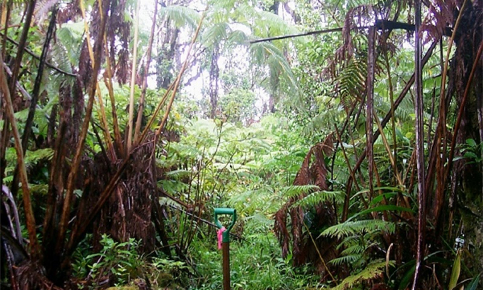
`Ohi`a lehua - koa/hapu`u/Old World forked fern (uluhe)
Figure 7. Reference community phase. 9/19/06 D Clausnitzer MU604

Figure 8. Understory. 9/19/06 D Clausnitzer MU604

Figure 9. Ground level. 9/19/06 D Clausnitzer MU604
This community phase is a four-tiered forest with an open overstory of large trees, a diverse, open secondary tree, a tree fern canopy, and an understory of shrubs, herbs, and ferns. These forests have standing live timber of 200 to 1000 cubic feet per acre, with a representative value of about 600 cubic feet per acre.
Koa trees appear to occur mostly in limited areas in the northern parts of this ecological site with seed sources from older koa-ohia forests on Mauna Kea or in kipukas.
The shallowest and/or youngest soils in this ecological site tend to support extensive, dense stands of uluhe or Old World forkedfern (Dicranopteris linearis) with relatively open canopies of emergent trees and shrubs. As tree canopies become more closed over time, uluhe density may decrease and the sites will become more like the central concept.Forest overstory.The open overstory consists of ohia lehua (Metrosideros polymorpha) or ohia lehua and koa (Acacia koa) 60 to 75 feet (18 to 23 meters) tall and up to 36 inches (90 centimeters) diameter at breast height, an open secondary canopy of diverse trees species 15 to 25 feet (4.6 to 8 meters) tall, a tree fern canopy 10 to 15 feet (3 to 4.6 meters) tall with 30 to 60 percent cover, and an understory of shrubs, forbs, and ferns.<br /> <br /> The native loulu palm (Pritchardia beccariana) appears to occur only on older geologic areas of this ecological site, at least in the present day. While koa occurs on all soil map units and geologic ages of the ecological site, occurrence of koa appears to be related to proximity to seed sources on much older surfaces on Mauna Kea or in kipukas. Koa have not been observed growing on ponded soils, but do occur on saturated soils or on small hummocks of Kopua soils that are surrounded by ponded soils.<br />
Forest understory. The secondary canopy is a diverse array of common Hawaiian rainforest trees.<br /> <br /> The tertiary canopy contains small trees but is dominated by two species of hapuu or tree ferns, hapuu (Cibotium glaucum) and hapuu ii or hapuu li (Cibotium menziesii). Cibotium glaucum is the more abundant of the two species. <br /> <br /> The lowest canopy stratum, which ranges in height from the ground to about 4.5 feet (1.5 meters), consists of seedlings and immature individuals of species in the taller strata, small shrub species, forbs, vines, sedges, and ferns and fern allies. Uluhe (Dicranopteris linearis), pukiawe (Styphelia tameiameiae), and ohelo kau lau (Vaccinium calycinum) are more abundant here than in other Hawaiian moist forest ecological sites due to the increased amount of light penetrating the relatively open upper canopies. Small ferns are diverse and abundant on the ground, on downed logs, and on live tree trunks.
Table 5. Soil surface cover
Tree basal cover 0-0% Shrub/vine/liana basal cover 0-0% Grass/grasslike basal cover 0% Forb basal cover 0-0% Non-vascular plants 0-10% Biological crusts 0-0% Litter 50-60% Surface fragments >0.25" and <=3" 0% Surface fragments >3" 0% Bedrock 0% Water 0-20% Bare ground 0-0% Table 6. Woody ground cover
Downed wood, fine-small (<0.40" diameter; 1-hour fuels) – Downed wood, fine-medium (0.40-0.99" diameter; 10-hour fuels) – Downed wood, fine-large (1.00-2.99" diameter; 100-hour fuels) – Downed wood, coarse-small (3.00-8.99" diameter; 1,000-hour fuels) 0-1% Downed wood, coarse-large (>9.00" diameter; 10,000-hour fuels) 0-1% Tree snags** (hard***) – Tree snags** (soft***) – Tree snag count** (hard***) 0-0 per acre Tree snag count** (hard***) 0-0 per acre * Decomposition Classes: N - no or little integration with the soil surface; I - partial to nearly full integration with the soil surface.
** >10.16cm diameter at 1.3716m above ground and >1.8288m height--if less diameter OR height use applicable down wood type; for pinyon and juniper, use 0.3048m above ground.
*** Hard - tree is dead with most or all of bark intact; Soft - most of bark has sloughed off.
Table 7. Canopy structure (% cover)
Height Above Ground (ft) Tree Shrub/Vine Grass/
GrasslikeForb <0.5 0% 0% 0% 0% >0.5 <= 1 0% 0% 0-1% 3-5% >1 <= 2 0-1% 0-1% 0-1% 10-15% >2 <= 4.5 1-5% 5-10% 0-1% 1-2% >4.5 <= 13 30-50% 0-1% – 1-2% >13 <= 40 25-35% – – – >40 <= 80 1-2% – – – >80 <= 120 – – – – >120 – – – – State 2
Naturalized Grassland StateThis state is comprised of three community phases. Continuous grazing that does not allow the favored forage species time to recover from defoliation results brings a phase change to phase 2.2, which is dominated by lower value forage species but contains enough remnant desirable grass species to allow for a change back to phase 2.1 with prescribed grazing. Longer-term continuous grazing leads to phase 2.3, which consists of low value grass species and increasing cover of weedy shrubs, tree saplings, and vines.
Community 2.1
Californiagrass/ticktrefoil
Figure 10. Californiagrass. D Clausnitzer generic photo
This phase is maintained by application of prescribed grazing. Invasion by broomsedge bluestem and beardgrass or bushybeard bluestem (Schizachyrium condensatum) may be kept in check by increasing soil pH through lime applications and by mowing these tall weedy grasses before they set seed.
Forest overstory.This phase typically has few or no trees.
Forest understory. The dominant grass species is typically Californiagrass or para grass (Urochloa mutica), often with an admixture of leguminous desmodium (Desmodium spp.).
Figure 11. Annual production by plant type (representative values) or group (midpoint values)
Community 2.2
Broomsedge bluestem - hilograss
Figure 12. Broomsedge bluestem and hilograss. D Clausnitzer generic photo
This phase is maintained by application of prescribed grazing and, when needed, weed control methods. It is dominated by grasses of lower forage value than phase 2, and cover of weedy shrubs and forbs has increased.
Forest overstory.This phase typically has few or no trees.
Forest understory. The most abundant grasses typically are broomsedge bluestem (Andropogon virginicus), bushybeard bluestem (Schizachyrium condensatum), hilograss (Paspalum conjugatum), and common carpetgrass (Axonopus fissifolius). Californiagrass or para grass (Urochloa mutica) is still common. Sourbush (Pluchea carolinensis) is common. Seedlings of common guava (Psidium guajava) and strawberry guava (Psidium cattleianum) are common.
Table 8. Soil surface cover
Tree basal cover 0% Shrub/vine/liana basal cover 0.0-0.5% Grass/grasslike basal cover 30-30% Forb basal cover 0% Non-vascular plants 0-0% Biological crusts 0% Litter 60-70% Surface fragments >0.25" and <=3" 0% Surface fragments >3" 0% Bedrock 0% Water 0% Bare ground 10-10% Table 9. Canopy structure (% cover)
Height Above Ground (ft) Tree Shrub/Vine Grass/
GrasslikeForb <0.5 0% 0% 1-2% 0-1% >0.5 <= 1 0% 0-1% 25-35% 1-2% >1 <= 2 0-1% 1-1% 25-40% 2-3% >2 <= 4.5 0-1% 5-15% 35-45% 0-1% >4.5 <= 13 0-1% – – – >13 <= 40 – – – – >40 <= 80 – – – – >80 <= 120 – – – – >120 – – – – Community 2.3
Strawberry guava/princess flower (glorybush)/hilograss - common carpetgrass
Figure 13. Weedy grassland. D Clausnitzer generic photo
This phase is dominated by low value forage species and weedy shrubs, vines, and forbs.
Forest overstory.An open overstory of strawberry guava (Psidium cattleianum) may have grown.
Forest understory. The most abundant grasses typically are broomsedge bluestem (Andropogon virginicus), bushybeard bluestem (Schizachyrium condensatum), hilograss (Paspalum conjugatum), and common carpetgrass (Axonopus fissifolius). Strawberry guava is abundant, along with glorybush or princess-flower (Tibouchina urvilleana), Koster’s curse (Clidemia hirta), sourbush (Pluchea carolinensis), and introduced blackberries (Rubus ellipticus and R. rosifolius). Native uluhe (Dicranopteris linearis) is often abundant as thickets. Many species of introduced forbs may be present.
Table 10. Soil surface cover
Tree basal cover 0-0% Shrub/vine/liana basal cover 0-0% Grass/grasslike basal cover 10-20% Forb basal cover 0.5% Non-vascular plants 0-0% Biological crusts 0% Litter 60-70% Surface fragments >0.25" and <=3" 0-0% Surface fragments >3" 0-0% Bedrock 0% Water 0% Bare ground 0-10% Table 11. Woody ground cover
Downed wood, fine-small (<0.40" diameter; 1-hour fuels) – Downed wood, fine-medium (0.40-0.99" diameter; 10-hour fuels) – Downed wood, fine-large (1.00-2.99" diameter; 100-hour fuels) – Downed wood, coarse-small (3.00-8.99" diameter; 1,000-hour fuels) 0-1% Downed wood, coarse-large (>9.00" diameter; 10,000-hour fuels) – Tree snags** (hard***) – Tree snags** (soft***) – Tree snag count** (hard***) Tree snag count** (hard***) * Decomposition Classes: N - no or little integration with the soil surface; I - partial to nearly full integration with the soil surface.
** >10.16cm diameter at 1.3716m above ground and >1.8288m height--if less diameter OR height use applicable down wood type; for pinyon and juniper, use 0.3048m above ground.
*** Hard - tree is dead with most or all of bark intact; Soft - most of bark has sloughed off.
Table 12. Canopy structure (% cover)
Height Above Ground (ft) Tree Shrub/Vine Grass/
GrasslikeForb <0.5 0% 0-1% 1-2% 1-2% >0.5 <= 1 0% 1-2% 10-20% 5-10% >1 <= 2 1-1% 1-2% 20-30% 5-10% >2 <= 4.5 1-2% 15-20% 5-15% 1-2% >4.5 <= 13 1-10% 25-35% – – >13 <= 40 0-2% – – – >40 <= 80 – – – – >80 <= 120 – – – – >120 – – – – Pathway 2.1A
Community 2.1 to 2.2
Californiagrass/ticktrefoil
Broomsedge bluestem - hilograssThis phase degrades to phase 2.2 by continuous grazing that weakens preferred grass species in relation to less desirable forage species.
Pathway 2.2A
Community 2.2 to 2.1
Broomsedge bluestem - hilograss
Californiagrass/ticktrefoilThis phase can be converted to phase 2.1 by prescribed grazing. A prescribed grazing plan provides for intensive but temporary grazing of pastures that ensures that cattle consume some low-value forage species along with preferred forages and allows preferred forages time to recover from defoliation. The grazing plan may require splitting the herd, creating additional water sources, and creating multiple pastures by cross-fencing. Some weed control methods may need to be applied.
Pathway 2.2B
Community 2.2 to 2.3
Broomsedge bluestem - hilograss
Strawberry guava/princess flower (glorybush)/hilograss - common carpetgrassThis phase degrades to phase 2.3 by long-term continuous grazing and continued weed invasion and growth. Remnant desirable forage species have been much reduced and replaced by low value forage grasses.
Pathway 2.3A
Community 2.3 to 2.1
Strawberry guava/princess flower (glorybush)/hilograss - common carpetgrass
Californiagrass/ticktrefoilThis phase can be converted to phase 2.1 by a combination of weed control, prescribed grazing, and replanting of desirable forage species. Weeds such as blackberries, sourbush, and strawberry guava are not controllable by domestic livestock and must be killed with herbicide. The grazing prescription will require removal of livestock until seeded forage species have reestablished adequately to support grazing. Thereafter, the grazing plan may require splitting the herd, creating additional water sources, and creating multiple pastures by cross-fencing.
State 3
Invaded Understory StateThis state consists of one community phase. It has an intact or diminished overstory of native trees and a dense understory of introduced shrubs, grasses, ferns, and small trees. Native species are unable to regenerate eventually die out, leading to a transition to State 5 Invaded Overstory and Understory. Mechanical clearing could restore this state to State 2 Naturalized Grassland. Intensive efforts may enable restoration to State 1 Reference.
Community 3.1
`Ohi`a lehua - strawberry guava/princess flower (glorybush)
Figure 14. Ohia lehua and hapuu with weedy understory. D Clausnitzer generic photo
Most native species are unable to regenerate, but small populations of kopiko (Psychotria sp.) and hapuu (Cibotium glaucum) appear able to persist in the understory for a time.
Forest overstory.The overstory consists of ohia lehua (Metrosideros polymorpha) or a combination of ohia lehua and koa (Acacia koa).
Forest understory. The most abundant species are strawberry guava (Psidium cattleianum), Koster’s curse (Clidemia hirta), and glorybush (Tibouchina urvilleana). Yellow Himalayan raspberry (Rubus ellipticus) often forms thickets. Palmgrass (Setaria palmifolia) is common. Some uluhe (Dicranopteris linearis) may persist.
Table 13. Soil surface cover
Tree basal cover 0-0% Shrub/vine/liana basal cover 0.5-1.0% Grass/grasslike basal cover 0-0% Forb basal cover 0.5-1.0% Non-vascular plants 20-30% Biological crusts 0% Litter 60-70% Surface fragments >0.25" and <=3" 0% Surface fragments >3" 0% Bedrock 0% Water 0% Bare ground 10-10% Table 14. Woody ground cover
Downed wood, fine-small (<0.40" diameter; 1-hour fuels) – Downed wood, fine-medium (0.40-0.99" diameter; 10-hour fuels) – Downed wood, fine-large (1.00-2.99" diameter; 100-hour fuels) – Downed wood, coarse-small (3.00-8.99" diameter; 1,000-hour fuels) 0-1% Downed wood, coarse-large (>9.00" diameter; 10,000-hour fuels) 0-1% Tree snags** (hard***) – Tree snags** (soft***) – Tree snag count** (hard***) 0-0 per acre Tree snag count** (hard***) 0-0 per acre * Decomposition Classes: N - no or little integration with the soil surface; I - partial to nearly full integration with the soil surface.
** >10.16cm diameter at 1.3716m above ground and >1.8288m height--if less diameter OR height use applicable down wood type; for pinyon and juniper, use 0.3048m above ground.
*** Hard - tree is dead with most or all of bark intact; Soft - most of bark has sloughed off.
Table 15. Canopy structure (% cover)
Height Above Ground (ft) Tree Shrub/Vine Grass/
GrasslikeForb <0.5 0% 0% 0-1% 1-2% >0.5 <= 1 0-1% 0-1% 3-5% 5-10% >1 <= 2 0-1% 1-1% 3-5% 5-10% >2 <= 4.5 3-5% 10-15% 0-1% – >4.5 <= 13 10-15% 15-25% – – >13 <= 40 15-25% – – – >40 <= 80 25-50% – – – >80 <= 120 – – – – >120 – – – – State 4
Invaded Overstory and Understory StateThis state is comprised of one community phase dominated by introduced species in both the overstory and understory. It should be possible to restore this state to State 2 Naturalized Grassland by intensive mechanical clearing, weed control, and planting forage species.
Community 4.1
Strawberry guava
Figure 15. Strawberry guava; Ihope soil series. D Clausnitzer generic photo
Strawberry guava is typically the dominant tree species because it invades sites by seeds spread by pigs and reproduces vegetatively by root suckers. Strawberry guava appears able to dominate a site indefinitely because of the dense shade it produces and the competitive advantage of its very dense root system. Strawberry guava can reproduce and grow under these shady canopies.
Forest overstory.The overstory consists of a dense stand of strawberry guava (Psidium cattleianum).
Forest understory. There is little or no understory under dense stands of strawberry guava.
Table 16. Soil surface cover
Tree basal cover 0-0% Shrub/vine/liana basal cover 0% Grass/grasslike basal cover 0% Forb basal cover 0% Non-vascular plants 20-20% Biological crusts 0% Litter 60-70% Surface fragments >0.25" and <=3" 0% Surface fragments >3" 0% Bedrock 0% Water 0% Bare ground 10-20% Table 17. Woody ground cover
Downed wood, fine-small (<0.40" diameter; 1-hour fuels) – Downed wood, fine-medium (0.40-0.99" diameter; 10-hour fuels) – Downed wood, fine-large (1.00-2.99" diameter; 100-hour fuels) – Downed wood, coarse-small (3.00-8.99" diameter; 1,000-hour fuels) 0-1% Downed wood, coarse-large (>9.00" diameter; 10,000-hour fuels) 0-1% Tree snags** (hard***) – Tree snags** (soft***) – Tree snag count** (hard***) 0-0 per acre Tree snag count** (hard***) 0-0 per acre * Decomposition Classes: N - no or little integration with the soil surface; I - partial to nearly full integration with the soil surface.
** >10.16cm diameter at 1.3716m above ground and >1.8288m height--if less diameter OR height use applicable down wood type; for pinyon and juniper, use 0.3048m above ground.
*** Hard - tree is dead with most or all of bark intact; Soft - most of bark has sloughed off.
Table 18. Canopy structure (% cover)
Height Above Ground (ft) Tree Shrub/Vine Grass/
GrasslikeForb <0.5 0% 0% 0% 0% >0.5 <= 1 0% 0% 0% 0% >1 <= 2 0-1% 0% 0% 0% >2 <= 4.5 3-5% 0% – 0% >4.5 <= 13 50-80% 0% – – >13 <= 40 20-50% – – – >40 <= 80 0-1% – – – >80 <= 120 – – – – >120 – – – – State 5
Uluhe-Invaded StateThis state is comprised of one plant community dominated by dense thickets of uluhe fern. It forms where disturbance has cleared the original forest and introduced weeds are not abundant, allowing uluhe to cover the ground. This state should restore itself to State 1 Reference over time.
Community 5.1
`Ohi`a lehua/Old World forkedfern (uluhe)
Figure 16. Dense uluhe fern thicket. D Clausnitzer generic photo
This community phase consists of dense thickets of uluhe fern that grow up to about 10 feet (3 meters) high with emergent native trees and tree ferns.
Forest overstory.The overstory consists of ohia lehua (Metrosideros polymorpha), sometimes in combination with a few koa (Acacia koa). Occasionally, small numbers of other native tree species occur.
Forest understory. The understory is primarily uluhe (Dicranopteris linearis). However, a diverse assemblage of typical Hawaiian moist forest trees typically occurs. Canopy cover of hapuu (Cibotium glaucum) often is around 20%.
Table 19. Soil surface cover
Tree basal cover 0-0% Shrub/vine/liana basal cover 0% Grass/grasslike basal cover 0% Forb basal cover 0-0% Non-vascular plants 20-20% Biological crusts 0% Litter 80-80% Surface fragments >0.25" and <=3" 0-0% Surface fragments >3" 0-0% Bedrock 0% Water 0% Bare ground 0-0% Table 20. Woody ground cover
Downed wood, fine-small (<0.40" diameter; 1-hour fuels) – Downed wood, fine-medium (0.40-0.99" diameter; 10-hour fuels) – Downed wood, fine-large (1.00-2.99" diameter; 100-hour fuels) – Downed wood, coarse-small (3.00-8.99" diameter; 1,000-hour fuels) 0% Downed wood, coarse-large (>9.00" diameter; 10,000-hour fuels) 0% Tree snags** (hard***) – Tree snags** (soft***) – Tree snag count** (hard***) 0-0 per acre Tree snag count** (hard***) 0-0 per acre * Decomposition Classes: N - no or little integration with the soil surface; I - partial to nearly full integration with the soil surface.
** >10.16cm diameter at 1.3716m above ground and >1.8288m height--if less diameter OR height use applicable down wood type; for pinyon and juniper, use 0.3048m above ground.
*** Hard - tree is dead with most or all of bark intact; Soft - most of bark has sloughed off.
Table 21. Canopy structure (% cover)
Height Above Ground (ft) Tree Shrub/Vine Grass/
GrasslikeForb <0.5 0% 0% 0% 0% >0.5 <= 1 0% 0% 0-1% 0% >1 <= 2 0% 1-1% 0-1% 1-2% >2 <= 4.5 1-1% 3-5% – 30-40% >4.5 <= 13 1-20% 0-1% – 40-50% >13 <= 40 0-30% – – – >40 <= 80 – – – – >80 <= 120 – – – – >120 – – – – Transition T1A
State 1 to 2This state transitions to State 2 Naturalized Grassland by clearing the forest with heavy machinery and planting desirable forage species. Native forest may be cleared gradually by allowing cattle uncontrolled access to the forest. Cattle eventually eat or destroy understory ferns, forbs, shrubs, and saplings, opening up the forest so that forage grasses will thrive.
Transition T1B
State 1 to 3This state can transition to State 4 Native Forest with Invaded Understory by gradual replacement of the understory by introduced shrubs, vines, ferns, and small trees that outcompete the native understory species. This process is accelerated by ungulate foraging that disturbs the soil surface and directly destroys native plants and prevents their regeneration.
Transition T1C
State 1 to 5This state transitions to State 5 Uluhe Invaded Understory by mechanical land clearing or wildfire clear areas of forest that are not near seed sources of invasive, introduced plants.
Restoration pathway R2A
State 2 to 1It may be possible to restore this state to a facsimile of State 1 Reference. Weed control must be applied to forage species and the many opportunistic weeds that invade the site. Weed control would be a perpetual process to capture and maintain the site. Domestic and feral ungulates would be excluded from the restoration site, but domestic ungulates would be useful to manage vegetation outside the restoration site perimeter. Extensive planting of native species would follow.
Transition T2A
State 2 to 4This state transitions to State 4 Invaded Over and Understory by abandonment of grazing areas, which leads to rapid invasion of weedy tree species that take over from the initial growth of weedy vines and shrubs. The most common tree species is strawberry guava.
Restoration pathway R3A
State 3 to 1From this state, it may be possible to restore a facsimile of State 1 Reference. Before restoration of native plants, introduced understory plants must be eliminated by weed control and brush management practices, and ungulates must be excluded from the restoration site.
Transition T3B
State 3 to 2This state may be restored to State 2 Naturalized Grassland by mechanical clearing of weedy and remnant native understory plants; native overstory trees may be harvested for timber, destroyed, or left for shade. If leaving native trees for shade, care must be taken to not damage roots within about 20 feet (6 meters) of the trees. Introduced forage grasses may then be seeded. Herbicide applications will be necessary before and during forage establishment to control reemerging weed species.
Transition T3A
State 3 to 4This state transitions to State 4 Invaded Overstory and Understory because the native trees that form the overstory of are unable to regenerate in the dense weed understory. Eventually the mature native trees die without replacement and introduced tree species grow to form a new overstory.
Restoration pathway R4A
State 4 to 2This state may be restored to State 2 Naturalized Grassland by mechanical clearing of overstory and understory vegetation. Introduced forage grasses may then be seeded into the site. Herbicide applications will be necessary before and during forage establishment to control reemerging weed species.
Restoration pathway R5A
State 5 to 1With few or no weeds present, this state would be expected to restore itself to State 1 Reference as emergent native tree and tree fern canopies increase. If some alien weeds are present, timely weed control can prevent them from achieving dominance.
Transition T5A
State 5 to 2This state may transition to State 2 Naturalized Grassland by wildfire or by mechanical clearing, followed by intentional establishment or invasion of grasses.
Additional community tables
Table 22. Community 1.1 plant community composition
Group Common name Symbol Scientific name Annual production () Foliar cover (%) Table 23. Community 1.1 forest overstory composition
Common name Symbol Scientific name Nativity Height ft Canopy cover (%) Diameter in Basal area (square ft/acre) Tree'ohi'a lehua MEPO5 Metrosideros polymorpha Native 13-40 15-30 – 0 koa ACKO Acacia koa Native 13-40 1-5 – 0 wild coffee PSYCH Psychotria Native 13-25 0-1 – 0 kolea lau nui MYLE2 Myrsine lessertiana Native 13-40 0-1 – 0 mirrorplant COPRO Coprosma Native 13-20 0-1 – 0 ha'a ANPL2 Antidesma platyphyllum Native 13-16 0-1 – 0 olapalapa CHTR2 Cheirodendron trigynum Native 13-30 0-1 – 0 Hawai'i holly ILAN Ilex anomala Native 13-25 0-1 – 0 koa ACKO Acacia koa Native 40-65 0-1 – 0 'ohi'a lehua MEPO5 Metrosideros polymorpha Native 40-60 0-1 – 0 Kilauea pritchardia PRBE Pritchardia beccariana Native 40-50 0-0.5 – 0 Kilauea pritchardia PRBE Pritchardia beccariana Native 13-40 0-0.5 – 0 Tree Fernhapu'u CIGL Cibotium glaucum Native 13-18 0-1 – 0 hapu'u li CIME8 Cibotium menziesii Native 13-16 0-1 – 0 Table 24. Community 1.1 forest understory composition
Common name Symbol Scientific name Nativity Height (ft) Canopy cover (%) Grass/grass-like (Graminoids)twigrush MACHA2 Machaerina Native 2–3 0–0.5 Hawai'i sedge CAAL12 Carex alligata Native 1–2 0 Forb/Herbpua'akuhinia ASME4 Astelia menziesiana Native 0.5–1 0–1 peperomia PEPER Peperomia Native 0.5–1 0–1 Fern/fern allyOld World forkedfern DILI Dicranopteris linearis Native 2–5 5–15 Hawai'i umbrella fern STOW Sticherus owhyensis Native 2–5 0–1 akolea ATMI Athyrium microphyllum Native 1–2 0–1 Pacific woodfern DRSA Dryopteris sandwicensis Native 1–3 0–1 alpine woodfern DRWA Dryopteris wallichiana Native 1–2 0–1 scrambling fern DIPI3 Diplopterygium pinnatum Native 2–5 0–1 sadleria SADLE Sadleria Native 2–3 0–1 vandenboschia VANDE Vandenboschia Native 0.5–1 0–0.5 Old World adderstongue OPPEP Ophioglossum pendulum ssp. pendulum Native 0.5–1 0–0.5 staghorn clubmoss LYCE2 Lycopodiella cernua Native 0.5–1 0–0.5 whisk fern PSNU Psilotum nudum Native 0.5–1 0–0.5 flatfork fern PSCO3 Psilotum complanatum Native 0.5–1 0–0.5 wahini noho mauna ADTA Adenophorus tamariscinus Native 0.5–1 0–0.5 royal tonguefern ELCR2 Elaphoglossum crassifolium Native 0.5–1 0–0.5 kolokolo GRTE Grammitis tenella Native 0.2–0.5 0–0.5 Chinese creepingfern ODCH Odontosoria chinensis Native 1–2 0 Shrub/Subshrubohelo kau la'au VACA8 Vaccinium calycinum Native 2–5 1–5 pukiawe STTA Styphelia tameiameiae Native 2–5 1–5 kanawao BRAR6 Broussaisia arguta Native 2–5 0–1 Waimea pipturus PIAL2 Pipturus albidus Native 2–6 0–1 clermontia CLERM Clermontia Native 2–4 0–1 small treefern CYPA7 Cyathea parvula Native 1–2 0–1 forest cyrtandra CYGI3 Cyrtandra giffardii Native 2–3 0 forest cyrtandra CYGI3 Cyrtandra giffardii Native 2–3 0 pele clermontia CLPE2 Clermontia peleana Native 2–5 0 Treekokea lau li'i MYSA2 Myrsine sandwicensis Native 2–10 1–5 mirrorplant COPRO Coprosma Native 2–13 1–2 olapalapa CHTR2 Cheirodendron trigynum Native 2–13 1–2 ha'a ANPL2 Antidesma platyphyllum Native 2–13 0–1 variable starviolet HETE21 Hedyotis terminalis Native 2–10 0–1 Hawai'i holly ILAN Ilex anomala Native 2–13 0–1 olomea PESA3 Perrottetia sandwicensis Native 2–10 0–1 'ohi'a lehua MEPO5 Metrosideros polymorpha Native 2–13 0–1 wild coffee PSYCH Psychotria Native 2–13 0–1 kolea lau nui MYLE2 Myrsine lessertiana Native 2–13 0–1 Kilauea pritchardia PRBE Pritchardia beccariana Native 2–13 0–0.5 koa ACKO Acacia koa Native 2–13 0 'aku 'aku CYTR6 Cyanea tritomantha Native 2–10 0 Tree Fernhapu'u CIGL Cibotium glaucum Native 2–13 15–25 hapu'u li CIME8 Cibotium menziesii Native 2–13 5–10 Vine/Liana'ie'ie FRAR Freycinetia arborea Native 1–20 0–1 Maile ALST11 Alyxia stellata Native 2–8 0–1 forest starviolet HECE Hedyotis centranthoides Native 1–3 0 Hawai'i blackberry RUHA Rubus hawaiensis Native 2–4 0 Table 25. Community 2.1 plant community composition
Group Common name Symbol Scientific name Annual production () Foliar cover (%) Grass/Grasslike1 Naturalized Warm Season Midgrasses 4080–4320 para grass URMU Urochloa mutica 2880–4320 – dallisgrass PADI3 Paspalum dilatatum 48–192 – torpedo grass PARE3 Panicum repens 0–96 – common carpetgrass AXFI Axonopus fissifolius 48–96 – Oahu flatsedge CYHY2 Cyperus hypochlorus 0–48 – violet crabgrass DIVI2 Digitaria violascens 0–48 – shortleaf spikesedge KYBR Kyllinga brevifolia 0–48 – hilograss PACO14 Paspalum conjugatum 0–48 – Vasey's grass PAUR2 Paspalum urvillei 0–48 – glenwoodgrass SAIN Sacciolepis indica 0–48 – Colombian bluestem SCCO10 Schizachyrium condensatum 0–48 – marsh bristlegrass SEPA10 Setaria parviflora 0–48 – smut grass SPIN4 Sporobolus indicus 0–48 – broomsedge bluestem ANVI2 Andropogon virginicus 0–48 – Forb2 Naturalized Forbs 240–480 climbing dayflower CODI5 Commelina diffusa 48–144 – greenleaf ticktrefoil DEIN2 Desmodium intortum 0–96 – zarzabacoa comun DEIN3 Desmodium incanum 0–96 – Hawai'i ticktrefoil DESA81 Desmodium sandwicense 0–96 – threeflower ticktrefoil DETR4 Desmodium triflorum 0–48 – shameplant MIPU8 Mimosa pudica 0–48 – scaly swordfern NEHI Nephrolepis hirsutula 0–48 – light-blue snakeweed STJA Stachytarpheta jamaicensis 0–48 – Colombian waxweed CUCA4 Cuphea carthagenensis 0–48 – tropical whiteweed AGCO Ageratum conyzoides 0–48 – bamboo orchid ARGR6 Arundina graminifolia 0–48 – sensitive partridge pea CHNI2 Chamaecrista nictitans 0–48 – Shrub/Vine3 Naturalized Shrubs 48–144 soapbush CLHI3 Clidemia hirta 0–48 – strawberry guava PSCA Psidium cattleianum 0–48 – guava PSGU Psidium guajava 0–48 – Table 26. Community 2.2 plant community composition
Group Common name Symbol Scientific name Annual production () Foliar cover (%) Table 27. Community 2.2 forest understory composition
Common name Symbol Scientific name Nativity Height (ft) Canopy cover (%) Grass/grass-like (Graminoids)broomsedge bluestem ANVI2 Andropogon virginicus Introduced 2–3 25–35 hilograss PACO14 Paspalum conjugatum Introduced 0.5–1 15–25 Colombian bluestem SCCO10 Schizachyrium condensatum Introduced 2–3 5–15 common carpetgrass AXFI Axonopus fissifolius Introduced 0.5–1 5–15 para grass URMU Urochloa mutica Introduced 1–2 5–15 torpedo grass PARE3 Panicum repens Introduced 1–2 1–5 smut grass SPIN4 Sporobolus indicus Introduced 1–2 1–5 dallisgrass PADI3 Paspalum dilatatum Introduced 1–2 0–1 Job's tears COLA Coix lacryma-jobi Introduced 1–2 0–1 violet crabgrass DIVI2 Digitaria violascens Introduced 1–2 0–1 Vasey's grass PAUR2 Paspalum urvillei Introduced 1–2 0–1 shortleaf spikesedge KYBR Kyllinga brevifolia Introduced 0.5–1 0–1 glenwoodgrass SAIN Sacciolepis indica Introduced 0.5–1 0–1 marsh bristlegrass SEPA10 Setaria parviflora Introduced 1–2 0–1 Forb/HerbColombian waxweed CUCA4 Cuphea carthagenensis Introduced 0.5–1 1–5 light-blue snakeweed STJA Stachytarpheta jamaicensis Introduced 2–3 0–1 sensitive partridge pea CHNI2 Chamaecrista nictitans Introduced 0.2–0.5 0–1 shameplant MIPU8 Mimosa pudica Introduced 0.2–0.5 0–1 tropical whiteweed AGCO Ageratum conyzoides Introduced 1–2 0–1 climbing dayflower CODI5 Commelina diffusa Introduced 0.5–1 0–1 bamboo orchid ARGR6 Arundina graminifolia Introduced 2–3 0–1 zarzabacoa comun DEIN3 Desmodium incanum Introduced 0.5–1 0 threeflower ticktrefoil DETR4 Desmodium triflorum Introduced 0.5–1 0 Hawai'i ticktrefoil DESA81 Desmodium sandwicense Introduced 0.5–1 0 Shrub/Subshrubcure for all PLCA10 Pluchea carolinensis Introduced 2–4 1–10 soapbush CLHI3 Clidemia hirta Introduced 2–4 0–1 Treeguava PSGU Psidium guajava Introduced 2–8 0–1 strawberry guava PSCA Psidium cattleianum Introduced 2–5 0–1 Vine/Lianagreenleaf ticktrefoil DEIN2 Desmodium intortum Introduced 0.5–1 0 Table 28. Community 2.3 plant community composition
Group Common name Symbol Scientific name Annual production () Foliar cover (%) Table 29. Community 2.3 forest overstory composition
Common name Symbol Scientific name Nativity Height ft Canopy cover (%) Diameter in Basal area (square ft/acre) Treestrawberry guava PSCA Psidium cattleianum Introduced 13-16 0-2 – 0 Table 30. Community 2.3 forest understory composition
Common name Symbol Scientific name Nativity Height (ft) Canopy cover (%) Grass/grass-like (Graminoids)common carpetgrass AXFI Axonopus fissifolius Introduced 0.5–1 5–15 hilograss PACO14 Paspalum conjugatum Introduced 0.5–1 10–15 broomsedge bluestem ANVI2 Andropogon virginicus Introduced 2–3 3–5 Colombian bluestem SCCO10 Schizachyrium condensatum Introduced 2–3 3–5 para grass URMU Urochloa mutica Introduced 1–2 3–5 smut grass SPIN4 Sporobolus indicus Introduced 0.5–1 3–5 torpedo grass PARE3 Panicum repens Introduced 1–2 0–1 dallisgrass PADI3 Paspalum dilatatum Introduced 1–2 0–1 shortleaf spikesedge KYBR Kyllinga brevifolia Introduced 0.5–1 0–1 glenwoodgrass SAIN Sacciolepis indica Introduced 0.5–1 0–1 marsh bristlegrass SEPA10 Setaria parviflora Introduced 0.5–1 0–1 Vasey's grass PAUR2 Paspalum urvillei Introduced 1–2 0–1 Job's tears COLA Coix lacryma-jobi Introduced 1–2 0–1 violet crabgrass DIVI2 Digitaria violascens Introduced 1–2 0–1 Forb/HerbPhilippine ground orchid SPPL Spathoglottis plicata Introduced 1–2 0–1 sensitive partridge pea CHNI2 Chamaecrista nictitans Introduced 0.2–0.5 0–1 shameplant MIPU8 Mimosa pudica Introduced 0.2–0.5 0–1 tropical whiteweed AGCO Ageratum conyzoides Introduced 1–2 0–1 Colombian waxweed CUCA4 Cuphea carthagenensis Introduced 0.5–1 0–1 light-blue snakeweed STJA Stachytarpheta jamaicensis Introduced 2–3 0–1 climbing dayflower CODI5 Commelina diffusa Introduced 0.5–1 0–1 bamboo orchid ARGR6 Arundina graminifolia Introduced 1–2 0–1 Fern/fern allyOld World forkedfern DILI Dicranopteris linearis Native 1–4 5–10 staghorn clubmoss LYCE2 Lycopodiella cernua Native 0.5–1 0–0.5 Shrub/Subshrubprincess-flower TIUR Tibouchina urvilleana Introduced 2–8 5–15 cure for all PLCA10 Pluchea carolinensis Introduced 2–5 5–10 soapbush CLHI3 Clidemia hirta Introduced 2–4 3–5 Treestrawberry guava PSCA Psidium cattleianum Introduced 2–13 5–15 guava PSGU Psidium guajava Introduced 2–8 1–2 Vine/Lianayellow Himalayan raspberry RUEL3 Rubus ellipticus Introduced 2–4 3–5 West Indian raspberry RURO Rubus rosifolius Introduced 2–4 1–2 Table 31. Community 3.1 plant community composition
Group Common name Symbol Scientific name Annual production () Foliar cover (%) Table 32. Community 3.1 forest overstory composition
Common name Symbol Scientific name Nativity Height ft Canopy cover (%) Diameter in Basal area (square ft/acre) Tree'ohi'a lehua MEPO5 Metrosideros polymorpha Native 40-60 25-50 – 0 strawberry guava PSCA Psidium cattleianum Introduced 13-25 10-25 – 0 koa ACKO Acacia koa Native 40-60 5-10 – 0 wild coffee PSYCH Psychotria Native 13-25 1-2 – 0 olapalapa CHTR2 Cheirodendron trigynum Native 13-30 1-2 – 0 Hawai'i holly ILAN Ilex anomala Native 13-25 0-1 – 0 Table 33. Community 3.1 forest understory composition
Common name Symbol Scientific name Nativity Height (ft) Canopy cover (%) Grass/grass-like (Graminoids)palmgrass SEPA6 Setaria palmifolia Introduced 1–2 1–5 para grass URMU Urochloa mutica Introduced 1–2 0–1 glenwoodgrass SAIN Sacciolepis indica Introduced 0.5–1 0–1 hilograss PACO14 Paspalum conjugatum Introduced 0.5–1 0–1 Forb/HerbKahila garland-lily HEGA Hedychium gardnerianum Introduced 2–5 5–10 narrowleaf plantain PLLA Plantago lanceolata Introduced 0.2–0.5 0–1 Philippine ground orchid SPPL Spathoglottis plicata Introduced 2–3 0–1 Fern/fern allyOld World forkedfern DILI Dicranopteris linearis Native 2–5 1–5 Krauss' spikemoss SEKR Selaginella kraussiana Introduced 0.1–0.2 0–1 Shrub/Subshrubsoapbush CLHI3 Clidemia hirta Introduced 2–6 10–20 princess-flower TIUR Tibouchina urvilleana Introduced 2–13 10–15 Treestrawberry guava PSCA Psidium cattleianum Introduced 2–13 15–25 wild coffee PSYCH Psychotria Native 5–13 0–1 olapalapa CHTR2 Cheirodendron trigynum Native 5–13 0–1 Hawai'i holly ILAN Ilex anomala Native 8–13 0 Tree Fernhapu'u CIGL Cibotium glaucum Native 5–13 1–5 hapu'u li CIME8 Cibotium menziesii Native 5–13 1–2 Vine/Lianayellow Himalayan raspberry RUEL3 Rubus ellipticus Introduced 2–5 1–5 West Indian raspberry RURO Rubus rosifolius Introduced 2–4 0–1 'ie'ie FRAR Freycinetia arborea Native 1–10 0–1 Table 34. Community 4.1 plant community composition
Group Common name Symbol Scientific name Annual production () Foliar cover (%) Table 35. Community 4.1 forest overstory composition
Common name Symbol Scientific name Nativity Height ft Canopy cover (%) Diameter in Basal area (square ft/acre) Treestrawberry guava PSCA Psidium cattleianum Introduced 13-25 20-50 – 0 'ohi'a lehua MEPO5 Metrosideros polymorpha Native 40-60 0 – 0 'ohi'a lehua MEPO5 Metrosideros polymorpha Native 30-40 0 – 0 Table 36. Community 4.1 forest understory composition
Common name Symbol Scientific name Nativity Height (ft) Canopy cover (%) Fern/fern allyOld World forkedfern DILI Dicranopteris linearis Native 2–3 0 staghorn clubmoss LYCE2 Lycopodiella cernua Native 0.2–0.5 0 Shrub/Subshrubprincess-flower TIUR Tibouchina urvilleana Introduced 2–10 0 soapbush CLHI3 Clidemia hirta Introduced 2–4 0 Treestrawberry guava PSCA Psidium cattleianum Introduced 2–13 20–50 Malabar plum SYJA Syzygium jambos Introduced 1–2 0 Tree Fernhapu'u CIGL Cibotium glaucum Native 5–10 0 Table 37. Community 5.1 plant community composition
Group Common name Symbol Scientific name Annual production () Foliar cover (%) Table 38. Community 5.1 forest overstory composition
Common name Symbol Scientific name Nativity Height ft Canopy cover (%) Diameter in Basal area (square ft/acre) Tree'ohi'a lehua MEPO5 Metrosideros polymorpha Native 13-40 0-30 – 0 koa ACKO Acacia koa Native 13-40 0-1 – 0 olapalapa CHTR2 Cheirodendron trigynum Native 13-25 0-1 – 0 wild coffee PSYCH Psychotria Native 13-25 0-1 – 0 kolea lau nui MYLE2 Myrsine lessertiana Native 13-25 0-1 – 0 Table 39. Community 5.1 forest understory composition
Common name Symbol Scientific name Nativity Height (ft) Canopy cover (%) Grass/grass-like (Graminoids)twigrush MACHA2 Machaerina Native 2–3 0–0.5 Oahu sedge CAWA Carex wahuensis Native 1–2 0–0.5 Hawai'i sedge CAAL12 Carex alligata Native 1–2 0–0.5 Forb/Herbpeperomia PEPER Peperomia Native 0.5–1 0–0.5 Fern/fern allyOld World forkedfern DILI Dicranopteris linearis Native 2–13 70–85 Hawai'i umbrella fern STOW Sticherus owhyensis Native 2–13 5–10 scrambling fern DIPI3 Diplopterygium pinnatum Native 2–13 1–2 sadleria SADLE Sadleria Native 2–4 0–1 staghorn clubmoss LYCE2 Lycopodiella cernua Native 0.5–1 0–0.5 whisk fern PSNU Psilotum nudum Native 0.2–0.5 0–0.5 Shrub/Subshrubohelo kau la'au VACA8 Vaccinium calycinum Native 2–5 1–5 Waimea pipturus PIAL2 Pipturus albidus Native 2–10 0–1 clermontia CLERM Clermontia Native 2–6 0–1 pukiawe STTA Styphelia tameiameiae Native 2–5 0–1 kanawao BRAR6 Broussaisia arguta Native 2–6 0 Treewild coffee PSYCH Psychotria Native 2–13 0–1 kolea lau nui MYLE2 Myrsine lessertiana Native 2–13 0–1 'ohi'a lehua MEPO5 Metrosideros polymorpha Native 2–13 0–1 koa ACKO Acacia koa Native 2–13 0–1 olapalapa CHTR2 Cheirodendron trigynum Native 2–13 0–1 mirrorplant COPRO Coprosma Native 2–13 0–1 olomea PESA3 Perrottetia sandwicensis Native 2–13 0–1 kokea lau li'i MYSA2 Myrsine sandwicensis Native 2–13 0–1 Hawai'i holly ILAN Ilex anomala Native 2–13 0 Tree Fernhapu'u CIGL Cibotium glaucum Native 2–13 1–20 Vine/Lianaforest starviolet HECE Hedyotis centranthoides Native 2–4 0–0.5 'ie'ie FRAR Freycinetia arborea Native 1–10 0 Hawai'i blackberry RUHA Rubus hawaiensis Native 2–4 0 Interpretations
Animal community
This ecological site provides habitat to the following native birds: elepaio (Chasiempis sandwichensis), amakihi (Hemignathus virens), apapane (Himatione sanguinea), iiwi (Vestiaria coccinea), omao (Myadestes obscurus), akepa (Loxops coccineus), and akiapolaau (Hemignathus wilsoni). Species and populations may be limited by avian malaria carried by introduced mosquitoes. This ecological site also is home to the Hawaiian hoary bat or opeapea (Lasiurus cenarius semotus). These species may be encountered within all community phases but are most prevalent in open canopy native forest and forest adjacent to clearings. Community phases that provide open grassland or savannah-like settings provide habitat for the native Hawaiian hawk, or io (Buteo solitarius) and Hawaiian owl or pueo (Asio flammeus spp. sandwichensis).
This ecological site provides habitat to a variety of introduced birds. Species such as wild turkey (Meleagris gallopavo), ring-necked pheasant (Phasianus colchicus), Erckel’s francolin (Pternistis erckelii), black francolin (Francolinus francolinus), and kalij pheasant (Lophura leucomelanos) are considered to be game birds.
Feral pigs are abundant. They provide hunting opportunities but are very destructive to native vegetation. Public sport hunting typically does not have a major impact on their populations, especially in remote areas.
Introduced wildlife species are able to utilize all community phases within the ecological site.
Grazing Interpretations
The following table lists suggested initial stocking rates for cattle under the Forage Value Rating system for only community phase 2.1. These are conservative estimates that should be used only as guidelines in the initial stages of the conservation planning process. Sometimes the current plant composition does not entirely match any particular plant community described in this ecological site description. Because of this, a field visit is recommended to document plant composition and production. More precise carrying capacity estimates should eventually be calculated using the following stocking rate information along with animal preference data, particularly when grazers other than cattle are involved. Under more intensive grazing management, improved harvest efficiencies may result in an increased stocking rate.
Forage Value Rating (note 1)
Very High (note 2) 0.40-0.59 acre/AUM (note 3) 2.56-1.70 AUM/acre
High 0.59-0.78 acre/AUM 1.70-1.28 AUM/acre
Moderate 0.78-1.56 acre/AUM 1.28-0.64 AUM/acre
Low 1.56-+ acre/AUM 0.64-+ AUM/acre
(note 1) The Forage Value Rating System is not an ecological evaluation of community phase 2.1. It is a utilitarian rating of the existing forage value for that specific plant community.
(note 2) Conservationists must use considerable judgment, because some pastures in the Very High forage class could be producing less than normal volumes of forage, and adjustments would need to be made in the initial stocking rate.
(note 3) Stocking rates vary in accordance with such factors as kind and class of livestock or wildlife, season of use, and fluctuations in climate. Actual use records and on-site inventories for individual sites, together with a determination of the degree to which the sites have been grazed, offer the most reliable basis for developing initial stocking rates.
This plant community is suitable for grazing by all kinds and classes of livestock, at any season, particularly cattle. This site is suited for grazing by both cow-calf operations and stocker operations. However, sheep can be grazed on this site as well. This site is poorly suited to continuous year-long use if this plant community is to be maintained.Hydrological functions
This ecological site typically is found in low spots on the landscape, particularly kipukas surrounds by the better-drained soils of F162XY503. Soils are often saturated to the surface or ponded.
Recreational uses
Feral pigs may be hunted on this ecological site. Hiking and other access is limited by wetness and remote locations.
Wood products
None.
Other products
None.
Other information
Definitions
These definitions have been greatly simplified for brevity and do not cover every aspect of each topic.
Aa lava: A type of basaltic lava having a rough, jagged, clinkery surface and a vesicular interior.
Alluvial: Materials or processes associated with transportation and/or deposition by running water.
Aquic soil moisture regime: A regime in which the soil is free of dissolved oxygen because it is saturated by water. This regime typically exists in bogs or swamps.
Aridic soil moisture regime: A regime in which defined parts of the soil are, in normal years, dry for more than half of the growing season and moist for less than 90 consecutive days during the growing season. In Hawaii it is associated with hot, dry areas with plants such as kiawe, wiliwili, and buffelgrass. The terms aridic and torric are basically the same.
Ash field: a land area covered by a thick or distinctive deposit of volcanic ash that can be traced to a specific source and has well defined boundaries. The term “ash flow” is erroneously used in the Physiographic section of this ESD due to a flaw in the national database.
Ashy: A “soil texture modifier” for volcanic ash soils having a water content at the crop wilting point of less than 30 percent; a soil that holds relatively less water than “medial” and “hydrous” soils.
Available water capacity: The amount of soil water available to plants to the depth of the first root-restricting layer.
Basal area or basal cover: The cross sectional area of the stem or stems of a plant or of all plants in a stand.
Blue rock: The dense, hard, massive lava that forms the inner core of an aa lava flow.
Bulk density: the weight of dry soil per unit of volume. Lower bulk density indicates a greater amount of pore space that can hold water and air in a soil.
CaCO3 equivalent: The amount of free lime in a soil. Free lime exists as solid material and typically occurs in regions with a dry climate.
Canopy cover: The percentage of ground covered by the vertical projection downward of the outermost perimeter of the spread of plant foliage. Small openings within the canopy are included.
Community pathway: A description of the causes of shifts between community phases. A community pathway is reversible and is attributable to succession, natural disturbances, short-term climatic variation, and facilitating practices, such as grazing management.
Community phase: A unique assemblage of plants and associated dynamic soil properties within a state.
Dominant species: Plant species or species groups that exert considerable influence upon a community due to size, abundance, or cover.
Drainage class: The frequency and duration of a water table in a soil. There are seven drainage classes, ranging from “excessively drained” (soils with very rare or very deep water tables) to “well drained” (soils that provide ample water for plant growth but are not so wet as to inhibit root growth) to “very poorly drained” (soils with a water table at or near the surface during much of the growing season that inhibits growth of most plants).
Electrical conductivity (EC): A measure of the salinity of a soil. The standard unit is deciSiemens per meter (dS/m), which is numerically equivalent to millimhos per centimeter (mmhos/cm). An EC greater than about 4 dS/m indicates a salinity level that is unfavorable to growth of most plants.
Friability: A soil consistency term pertaining to the ease of crumbling of soils.
Hydrous: A “soil texture modifier” for volcanic ash soils having a water content at the crop wilting point of 100 percent or more; a soil that holds more water than “medial” or “ashy” soils.
Ion exchange capacity: The ability of soil materials such as clay or organic matter to retain ions (which may be plant nutrients) and to release those ions for uptake by roots.
Isohyperthermic soil temperature regime: A regime in which mean annual soil temperature is 72 degrees F (22 degrees C) or higher and mean summer and mean winter soil temperatures differ by less than 11 degrees F (6 degrees C) at a specified depth.
Isomesic soil temperature regime: A regime in which mean annual soil temperature is 47 degrees F (8 degrees C) or higher but lower than 59 degrees F (15 degrees C) and mean summer and mean winter soil temperatures differ by less than 11 degrees F (6 degrees C) at a specified depth.
Isothermic soil temperature regime: A regime in which mean annual soil temperature is 59 degrees F (15 degrees C) or higher but lower than 72 degrees F (22 degrees C) and mean summer and mean winter soil temperatures differ by less than 11 degrees F (6 degrees C) at a specified depth.
Kipuka: An area of land surrounded by younger (more recent) lava. Soils and plant communities within a kipuka are older than, and often quite different from, those on the surrounding surfaces.
Major Land Resource Area (MLRA): A geographic area defined by NRCS that is characterized by a particular pattern of soils, climate, water resources, and land uses. The island of Hawaii contains nine MLRAs, some of which also occur on other islands in the state.
Makai: a Hawaiian word meaning “toward the sea.”
Mauka: a Hawaiian word meaning “toward the mountain” or “inland.”
Medial: A “soil texture modifier” for volcanic ash soils having a water content at the crop wilting point of 30 to 100 percent; a soil that holds an amount of water intermediate to “hydrous” or “ashy” soils.
Naturalized plant community: A community dominated by adapted, introduced species. It is a relatively stable community resulting from secondary succession after disturbance. Most grasslands in Hawaii are in this category.
Pahoehoe lava: A type of basaltic lava with a smooth, billowy, or rope-like surface and vesicular interior.
Parent material: Unconsolidated and chemically weathered material from which a soil is developed.
Perudic soil moisture regime: A very wet regime found where precipitation exceeds evapotranspiration in all months of normal years. On the island of Hawaii, this regime is found on top of Kohala and on parts of the windward side of Mauna Kea.
pH: The numerical expression of the relative acidity or alkalinity of a soil sample. A pH of 7 is neutral; a pH below 7 is acidic and a pH above 7 is basic.
Phosphorus adsorption: The ability of soil materials to tightly retain phosphorous ions, which are a plant nutrient. Some volcanic ash soils retain phosphorus so strongly that it is partly unavailable to plants.
Reference community phase: The phase exhibiting the characteristics of the reference state and containing the full complement of plant species that historically occupied the site. It is the community phase used to classify an ecological site.
Reference state: A state that describes the ecological potential and natural or historical range of variability of an ecological site.
Restoration pathway: A term describing the environmental conditions and practices that are required to recover a state that has undergone a transition.
Sodium adsorption ratio (SAR): A measure of the amount of dissolved sodium relative to calcium and magnesium in the soil water. SAR values higher than 13 create soil conditions unfavorable to most plants.
Soil moisture regime: A term referring to the presence or absence either of ground water or of water held at a tension of less than 1500 kPa (the crop wilting point) in the soil or in specific horizons during periods of the year.
Soil temperature regime: A defined class based on mean annual soil temperature and on differences between summer and winter temperatures at a specified depth.
Soil reaction: Numerical expression in pH units of the relative acidity or alkalinity or a soil.
State: One or more community phases and their soil properties that interact with the abiotic and biotic environment to produce persistent functional and structural attributes associated with a characteristic range of variability.
State-and-transition model: A method used to display information about relationships between vegetation, soil, animals, hydrology, disturbances, and management actions on an ecological site.
Torric soil moisture regime: See Aridic soil moisture regime.
Transition: A term describing the biotic or abiotic variables or events that contribute to loss of state resilience and result in shifts between states.
Udic soil moisture regime: A regime in which the soil is not dry in any part for as long as 90 cumulative days in normal years, and so provides ample moisture for plants. In Hawaii it is associated with forests in which hapuu (tree ferns) are usually moderately to highly abundant.
Ustic soil moisture regime: A regime in which moisture is limited but present at a time when conditions are suitable for plant growth. In Hawaii it usually is associated with dry forests and subalpine shrublands.Supporting information
Type locality
Location 1: Hawaii County, HI Latitude 19° 34′ 34″ Longitude 155° 13′ 5″ General legal description From Hwy. 11, drive 12.25 miles W on Stainback Hwy. Stop at blocked jeep trail and walk northwest 0.5 mile to end. Climb down into kipuka and continue along foot trail another 0.1 mile. Other references
Armstrong RW. 1973. Atlas of Hawaii. University of Hawaii Press, Honolulu.
Athens JS. Ch. 12 Hawaiian Native Lowland Vegetation in Prehistory in Historical Ecology in the Pacific Islands – Prehistoric Environmental and Landscape Change. Kirch, PV and TL Hunt, eds. 1997. Yale U. Press, New Haven.
Burney DA, HF James, LP Burney, SL Olson, W Kikuchi, WL Wagner, M Burney, D McCloskey, D Kikuchi, FV Grady, R Gage II, and R Nishek. 2001. Fossil evidence for a diverse biota from Kauai and tis transformation since human arrival. Ecological Monographs 71:615-641.
Craighill ES and EG Handy. 1991. Native Planters in Old Hawaii – Their Life, Lore, and Environment. Bernice P. Bishop Museum Bulletin 233, Bishop Museum Press, Honolulu, HI
Cuddihy LW and CP Stone. 1990. Alteration of Native Hawaiian Vegetation: Effects of Humans, Their Activities and Introductions. Honolulu: University of Hawaii Cooperative National Park Resources Study Unit.
Hazlett RW and DW Hyndman. 1996. Roadside Geology of Hawaii. Mountain Press Publishing Company, Missoula MT.
Henke LA. 1929. A Survey of Livestock in Hawaii. Research Publication No. 5. University of Hawaii, Honolulu.
Jacobi JD. 1989. Vegetation Maps of the Upland Plant Communities on the Islands of Hawaii, Maui, Molokai, and Lanai. Technical Report 68. Cooperative National Park Resources Studies Unit, University of Hawaii at Manoa and National Park Service.
Kirch PV. 1982. The impact of the prehistoric Polynesians in the Hawaiian ecosystem. Pacific Science 36(1):1-14.
Kirch PV. 1985. Feathered Gods and Fishhooks: An Introduction to Hawaiian Archaeology and Prehistory. Honolulu: University of Hawaii Press.
Kirch PV. 2000. On the Road of the Winds: An Archaeological History of the Pacific Islands Before European Contact. Berkeley: University of California Press.
Little EL Jr. and RG Skolmen. 1989. Common Forest Trees of Hawaii (Native and Introduced). US Department of Agriculture-US Forest Service Agriculture Handbook No. 679. (out of print). Available at www.fs.fed.us/psw/publications/documents/misc/ah679.pdf
Maly K and O Maly. 2004. He Moolelo Aina: A Cultural Study of the Puu O Umi Natural Area Reserve and Kohala-Hamakua Mountain Lands, Districts of Kohala and Hamakua, Island of Hawaii. Kumu Pono Associates, Hilo HI.
Mueller-Dombois D and FR Fosberg. 1998. Vegetation of the Tropical Pacific Islands. Springer-Verlag New York, Inc.
Palmer DD. 2003. Hawaii’s Ferns and Fern Allies. University of Hawaii Press, Honolulu.
Pratt HD. 1998. A Pocket Guide to Hawaii’s Trees and Shrubs. Mutual Publishing, Honolulu.
Ripperton JC and EY Hosaka. 1942. Vegetation zones of Hawaii. Hawaii Agricultural Experiment Station Bulletin 89:1-60.
Rock JF. The Indigenous Trees of the Hawaiian Islands. 1st edition 1913, reprinted 1974, Charles E. Tuttle Company, Rutland, VT and Tokyo, Japan.
Shoji SD, M Nanzyo, and R Dahlgren. 1993. Volcanic Ash Soils: Genesis, Properties and Utilization. Elsevier, New York.
Sohmer SH. and R Gustafson. 2000. Plants and Flowers of Hawaii. University of Hawaii Press, Honolulu.
Steadman DW. 1995. Prehistoric extinctions of Pacific island birds: biodiversity meets zooarchaeology. Science 267:1123-1131.
USDA-NRCS-PIA T&E Species GIS files. Not publicly available.
USDI-USGS. 2006. A GAP Analysis of Hawaii. Final Report and Data.
Vitousek P. 2004. Nutrient Cycling and Limitation: Hawaii as a Model Ecosystem. Princeton University Press, Princeton and Oxford.
Wagner WL, DR Herbst, and SH Sohmer. 1999. Manual of the Flowering Plants of Hawaii, Revised Edition. Bishop Museum Press, Honolulu.
Whistler WA. 1995. Wayside Plants of the Islands: a Guide to the Lowland Flora of the Pacific Islands. Isle Botanica, Honolulu.Contributors
David Clausnitzer
Loretta Metz
Joseph MayApproval
Kendra Moseley, 5/08/2025
Acknowledgments
Assistance, advice, review, and/or insights: Mick Castillo Michael Constantinides, NRCS-PIA Susan Cordell, USFS Gordon Cran, Kapapala Ranch David Leonard, volunteer JB Friday, UH Forestry Extension Rick Gordon Basil Hansen, The Nature Conservancy Jennifer Higashino, USFWS and NRCS Flint Hughes, USFS Chris Jasper, NRCS Soil Survey Mel Johansen, The Nature Conservancy Kathy Kawakami, US Army Pohakuloa Training Ground Rhonda Loh, Volcanoes National Park Kamehameha Schools/Bishop Estate Miles Nakahara, Hawaii DOFAW Laura Nelson, The Nature Conservancy and NRCS Patrick Niemeyer, NRCS Soil Survey Billy Paris, rancher John Pipan Jon Price, USGS John Replogle, The Nature Conservancy Paul Scowcroft, USFS Earl Spence, grazing consultant Jim Thain Mike Tomich Quentin Tomich Tim Tunison, Volcanoes National Park Jill Wagner, consultant, Future Forests Rick Warschauer
Rangeland health reference sheet
Interpreting Indicators of Rangeland Health is a qualitative assessment protocol used to determine ecosystem condition based on benchmark characteristics described in the Reference Sheet. A suite of 17 (or more) indicators are typically considered in an assessment. The ecological site(s) representative of an assessment location must be known prior to applying the protocol and must be verified based on soils and climate. Current plant community cannot be used to identify the ecological site.
Author(s)/participant(s) Contact for lead author Date 09/29/2026 Approved by Approval date Composition (Indicators 10 and 12) based on Annual Production Indicators
-
Number and extent of rills:
-
Presence of water flow patterns:
-
Number and height of erosional pedestals or terracettes:
-
Bare ground from Ecological Site Description or other studies (rock, litter, lichen, moss, plant canopy are not bare ground):
-
Number of gullies and erosion associated with gullies:
-
Extent of wind scoured, blowouts and/or depositional areas:
-
Amount of litter movement (describe size and distance expected to travel):
-
Soil surface (top few mm) resistance to erosion (stability values are averages - most sites will show a range of values):
-
Soil surface structure and SOM content (include type of structure and A-horizon color and thickness):
-
Effect of community phase composition (relative proportion of different functional groups) and spatial distribution on infiltration and runoff:
-
Presence and thickness of compaction layer (usually none; describe soil profile features which may be mistaken for compaction on this site):
-
Functional/Structural Groups (list in order of descending dominance by above-ground annual-production or live foliar cover using symbols: >>, >, = to indicate much greater than, greater than, and equal to):
Dominant:
Sub-dominant:
Other:
Additional:
-
Amount of plant mortality and decadence (include which functional groups are expected to show mortality or decadence):
-
Average percent litter cover (%) and depth ( in):
-
Expected annual annual-production (this is TOTAL above-ground annual-production, not just forage annual-production):
-
Potential invasive (including noxious) species (native and non-native). List species which BOTH characterize degraded states and have the potential to become a dominant or co-dominant species on the ecological site if their future establishment and growth is not actively controlled by management interventions. Species that become dominant for only one to several years (e.g., short-term response to drought or wildfire) are not invasive plants. Note that unlike other indicators, we are describing what is NOT expected in the reference state for the ecological site:
-
Perennial plant reproductive capability:
Print Options
Sections
Font
AAAAOther
PrintThe Ecosystem Dynamics Interpretive Tool is an information system framework developed by the USDA-ARS Jornada Experimental Range, USDA Natural Resources Conservation Service, and New Mexico State University.
Accessibility statement


