
Natural Resources
Conservation Service
-
Search


Major Land Resource Area or ecological site by name and/or ID.
PreviousSectionsNextGeneral information
Provisional. A provisional ecological site description has undergone quality control and quality assurance review. It contains a working state and transition model and enough information to identify the ecological site.
Click to explore map
Figure 1. Mapped extent
Areas shown in blue indicate the maximum mapped extent of this ecological site. Other ecological sites likely occur within the highlighted areas. It is also possible for this ecological site to occur outside of highlighted areas if detailed soil survey has not been completed or recently updated.
MLRA notes
Major Land Resource Area (MLRA): 161B–Semiarid and Subhumid Organic Soils on Lava Flows
This MLRA occurs in the State of Hawaii in the Districts North and South Kona on the Big Island of Hawaii. This area is the leeward (western) side of the island on the slopes of Mauna Loa and Hualalai volcanoes. Elevation ranges from sea level to 6000 feet (about 2000 meters). Slopes follow the undulating to very steep topography of the lava flows. The flows are basaltic aa or pahoehoe lava, which are covered by a very shallow layer of organic material mixed with varying amounts of volcanic ash, although some places are covered only by volcanic ash. Climate ranges from dry to moist tropical. Average annual precipitation typically ranges from 30 to 80 inches (750 to 2000 millimeters), increasing with elevation. Rainfall occurs mostly in spring and summer. At higher elevations, frequent afternoon fog accumulation ameliorates evaporation and may add fog drip to the soil. Average annual air temperatures range from 55 to 75 degrees F (12 to 24 degrees C), with little seasonal variation. Dominant soils are Histosols and Andisols with isomesic to isohyperthermic soil temperature regimes. Very young lava flows may have no soil covering. Native vegetation changes as rainfall and fog increase with elevation. In the driest areas near sea level, sparse, low stature shrubs, grasses, and forbs predominate. Vegetation stature and density gradually increase with elevation to typical dry forest species such as lama, wiliwili, and alahee, transitional forest with olopua and papala kepau, rain forest with ohia lehua, koa, and hapuu, cool dry forest with koa, mamani, and mountain sandalwood, and finally cool dry shrublands that extend up to the highest unvegetated lava flows.
Classification relationships
This ecological site occurs within Major Land Resource Area (MLRA) 161B - Semiarid and Subhumid Organic Soils on Lava Flows.
Ecological site concept
This ecological site is the sparse shrubland situated on the high elevation, north and west facing slopes of Mauna Loa and south and southeast facing slopes of Hualalai. Much of the area is private land, with large areas held by Kamehameha Schools, the State of Hawaii, The Nature Conservancy, and the Federal government. The US Army Pohakuloa Training Area contains extensive parts of this ecological site.
The central concept of the Dry Ustic Isomesic Shrubland is of moderately well to somewhat excessively drained, very shallow to moderately deep soils formed in young deposits of volcanic ash, ash and cinders, or highly decomposed organic matter deposited primarily over pahoehoe lava. Soils generally range from 1500 to <5000 years old. Annual air temperatures and rainfall create cool (isomesic), seasonally dry (ustic) soil conditions. The temperature and moisture conditions override the diverse soil characteristics to the extent that a clearly definable ecological site exists across all the soil types within it. The vegetation is a dense to open shrubland with scattered trees and grasses and sedges beneath the shrub canopy or in interspaces between shrubs. There is a sparse canopy of ohia lehua (Metrosideros polymorpha) trees 25 to 50 feet (8 to 16 meters) tall and a sparse secondary canopy of mountain pilo (Coprosma montana), kolea (Myrsine lanaiensis), mamani (Sophora chrysophylla), naio (Myoporum sandwicense), and an occasional koa (Acacia koa). The shrub understory is dominated by pukiawe (Styphelia tameiameiae), ulei (Osteomeles anthyllidifolia), and aalii (Dodonaea viscosa). The most abundant grass species is alpine hairgrass (Deschampsia nubigena).Associated sites
VX161B01X503 Ustic Isomesic Forest
F161BY503 Ustic Isomesic Forest exists at similar and lower elevations to R161BY001 on both Hualalai and Mauna Loa volcanoes.
Similar sites
VX160X01X006 Isomesic Savanna
R160XY006 Isomesic Savanna occurs at similar elevations to R161BY001 on Mauna Loa volcano and to some extent on Hualalai volcano. It shares many species in common with R161BY001 but has greater tree cover and stature and more native grass cover due to higher rainfall and a higher ratio of rainfall to pan evaporation.
Table 1. Dominant plant species
Tree Not specified
Shrub (1) Styphelia tameiameiae
(2) Coprosma ernodeoidesHerbaceous Not specified
Legacy ID
R161BY001HI
Physiographic features
This ecological site occurs on lava flows on mountain slopes of shield volcanoes. Lava flows are mostly pahoehoe (smooth, relatively unbroken) or, to a small extent, aa (loose, cobbly) or covered with a layer of volcanic ash and cinders.
Table 2. Representative physiographic features
Landforms (1) Shield volcano
Flooding frequency None Ponding frequency None Elevation 3500 – 9000 ft Slope 2 – 50 % Water table depth 60 in Aspect Aspect is not a significant factor Climatic features
There are no climate stations near this ecological site with complete data sets suitable for automatically filling the data boxes and charts below.
The estimates in the following text are based on modeled climate maps and incomplete and/or historic data sets from multiple stations compiled by NRCS Hawaii Soil Survey.
The historic data shown below is from a suitably located weather station. Temperature data were not available. Average monthly precipitation is shown in the "High" row of data; monthly maximum and minimum were not available.
Average annual rainfall ranges from 20 to 30 inches (500 to 750 millimeters). Most rainfall occurs from January through May. Annual temperatures range from 47 to 57 degrees F (8 to 14 degrees C). Average annual pan evaporation ranges from 30 to 60 inches. The ratio of rainfall to pan evaporation generally range from 0.4 to 0.8, but may be as high as 1.0.
Dense fog forms over this ecological site on many afternoons; this would reduce evapotranspiration and possibly supply fog drip to the soil.Table 3 Representative climatic features
Frost-free period (average) 360 days Freeze-free period (average) 360 days Precipitation total (average) 10 in BarLineFigure 2. Monthly precipitation range
BarLineFigure 3. Monthly average minimum and maximum temperature
Figure 4. Annual precipitation pattern
Figure 5 Annual average temperature pattern
">Influencing water features
There are no water features that influence this ecological site.
Soil features
Parent materials of the majority of soils by area within this ecological site consist of either (1) very shallow organic matter over pahoehoe lava, (2) moderately deep to very deep volcanic ash over aa or pahoehoe that forms soils of low water holding capacity due to gravel and/or sand content and "ashy" (relatively low water holding capacity compared to "medial" and "hydrous") volcanic ash soil materials.
Soil moisture regimes are ustic, meaning that soil moisture is limited but is present at a time during the year when conditions are suitable for plant growth.
Contents of subsurface rock fragments <=3" diameter may be as high as 100% in some soil horizons that consist of volcanic cinders.
The volcanic ash soils of the Island of Hawaii are derived mostly from basaltic ash that varies relatively little in chemical composition (Hazlett and Hyndman 1996; Vitousek 2004)). Most of these volcanic ash soils are classified as Andisols, which have these general management characteristics: ion exchange capacity that varies with pH, but mostly retaining anions such as nitrate; high phosphorus adsorption, which restricts phosphorus availability to plants; excellent physical properties (low bulk density, good friability, weak stickiness, stable soil aggregates) for cultivation, seedling emergence, and plant root growth; resistance to compaction and an ability to recover from compaction following repeated cycles of wetting and drying; and high capacity to hold water that is available to plants. These characteristics are due to the properties of the parent material, the clay-size noncrystalline materials formed by weathering, and the soil organic matter accumulated during soil formation (Shoji et al. 1993).
Andisols formed on pahoehoe lava can be very shallow to very deep. Pahoehoe is referred to as a “lithic contact,” which is a boundary between soil and underlying material that is coherent, continuous, difficult to dig with a spade, and contains few cracks that can be penetrated by roots (Soil Survey Staff 1999). Pahoehoe is typically very limiting to root penetration due to the spacing and size of cracks. However, this characteristic of pahoehoe is variable, and there are many instances of stands of large trees growing on very shallow and shallow ash soils over pahoehoe.
The lava rock fragments that constitute aa range in size from gravel (2 mm to 76 mm, or up to 3 inches) to stones (250 mm to 600 mm, or 10 to 25 inches), but are primarily gravel and cobbles (76 mm to 250 mm, or 3 to 10 inches). Below the layer of rock fragments is massive lava called “bluerock.” The interstices between rock fragments of Andisols formed in aa are filled with soil from the surface to the blue rock at the bottom of the soil. Some Andisols in aa have few or no rock fragments in the upper horizons, while others may have large amounts of rock fragments in all horizons and on the soil surface.
Soils that are moderately deep (20 to 40 inches, or 50 to 100 cm) or deeper over underlying lava appear to present few or no limits on native, pasture, or weedy vegetation, and it seems to make no difference whether the lava rock is pahoehoe or aa.
The organic soils of the Island of Hawaii are classified as Histosols. They were formed mainly in organic material consisting of highly decomposed leaves, twigs, and wood with small amounts of basic volcanic ash, cinders, and weathered lava; this is called highly decomposed parent material. Some of these soils contain slightly or moderately decomposed parent material, especially at or near the soil surface.
Unlike many organic soils such as peat or muck that form in long-term water-saturated conditions, these organic soils form by accumulation and transformation of litter on dry surfaces of lava rock or in gaps between lava rocks. These organic soils are referred to as litter or an O horizon.
All of the Histosols on the Big Island are classified as “euic,” which means they have relatively high base saturation as indicated by a pH of 4.5 or higher; most Big Island Histosols have pH well above this minimum.
Histosols on pahoehoe lava tend to be shallow (less than 20 inches or 50 centimeters) or very shallow (less than 10 inches or 25 centimeters). Pahoehoe is referred to as a “lithic contact,” which is a boundary between soil and underlying material that is coherent, continuous, difficult to dig with a spade, and contains few cracks that can be penetrated by roots (Soil Survey Staff 1999). Pahoehoe is typically very limiting to root penetration due to the spacing and size of cracks. However, this characteristic of pahoehoe is variable, and there are many instances of large trees growing on very shallow and shallow soils over pahoehoe. When depth of soil to pahoehoe is less than 18 cm (7.2 inches), the soil is referred to as “micro.”
The lava rock fragments that constitute aa range in size from gravel (2 mm to 76 mm, or up to 3 inches) to stones (250 mm to 600 mm, or 10 to 25 inches), but are primarily gravel and cobbles (76 mm to 250 mm, or 3 to 10 inches). Below the layer of rock fragments is massive lava called “bluerock.” The interstices between rock fragments of Histosols formed in aa are filled with soil material from the surface to a particular depth, often moderately deep (20 to 40 inches, or 50 to 100 centimeters), but sometimes shallower or deeper depending on the soil series. Between this soil material-filled horizon and the bluerock the interstices contain little or no soil material. In order to observe the natural state of the soil, one must carefully disassemble the lava rock fragments so as not to allow the soil materials to fall into the gaps below.Table 4. Representative soil features
Parent material (1) Basaltic volcanic ash – basalt
Surface texture (1) Medial silt loam
(2) Ashy loamy sand
Drainage class Moderately well drained to somewhat excessively drained Permeability class Moderately rapid to very rapid Soil depth 2 – 40 in Surface fragment cover <=3" 0 – 60 % Surface fragment cover >3" 0 – 50 % Available water capacity
(0-40in)0.6 – 1.5 in Calcium carbonate equivalent
(0-40in)Not specified Electrical conductivity
(0-40in)0 – 2 mmhos/cm Sodium adsorption ratio
(0-40in)Not specified Soil reaction (1:1 water)
(0-40in)4.5 – 7.8 Subsurface fragment volume <=3"
(Depth not specified)0 – 100 % Subsurface fragment volume >3"
(Depth not specified)0 – 50 % Ecological dynamics
States and community phases within this ecological site were differentiated by inspection of data; ordination programs were not available. They were verified by professional consensus and consistent examples in the field.
This ecological site occurs on young lava flows in seasonally dry, cool regions of the west slope of Mauna Loa volcano, Hualalai volcano, and the saddle between those two volcanoes on the Island of Hawaii. Plant communities evolved without the presence of large mammals or frequent occurrence of fires.
The general appearance is a dense to open shrubland with scattered trees and an understory of grasses and sedges. Ohia trees are common and typically are 25 to 50 feet tall. Sandalwood, mamane, naio, dryland kolea (Myrsine lanaiensis), and mountain pilo are common smaller trees. Koa trees occur occassionally.
Invasion by exotic grasses and forbs can change the species content of State 1, Native Shrubland, without altering the general structure of the plant community. The result is State 2, Invaded Shrubland. However, invasion by silk oak or German ivy has the potential radically alter the plant community. Invasion by exotic grasses together with foraging by feral and/or domestic ungulates results in State 3, Grassland, due to destruction of many native species and prevention of their successful reproduction.
State 2 can shift to State 3 by frequent wildfires carried by exotic grasses. This is particularly true if fountaingrass has invaded the plant community in State 2. This shift from State 2 to State 3 due to fountaingrass invasion and wildfire has already occurred on areas of this ecological site near Puuwaawaa cinder cone at elevations between 3500 and 4000 feet. Dense fountaingrass stands of limited extent exist at elevations as high as 5200 feet, and the species occurs up to 8000 feet.State and transition model
Custom diagramStandard diagram
Figure 6. State and Transition Diagram Model R161BY001
More interactive model formats are also available. View Interactive Models
More interactive model formats are also available. View Interactive Models
Click on state and transition labels to scroll to the respective textEcosystem states
State 1 submodel, plant communities
State 2 submodel, plant communities
State 3 submodel, plant communities
State 1
Reference StateThis state consists of one community phase. Much of this ecological site is of marginal value as grazing land. Invasion by exotic grasses and forbs can change the species content of State 1 Reference without altering the general structure of the plant community, resulting in a transition to State 2 Invaded.
Invasion by silkoak (Grevillea robusta) and/or Cape ivy (Delairea odorata) has the eventual potential to radically alter the plant community. Invasion by introduced plant species such as those, together with loss of native species due to foraging by feral and/or domestic ungulates, results in State 3 Grazed and Browsed.Community 1.1
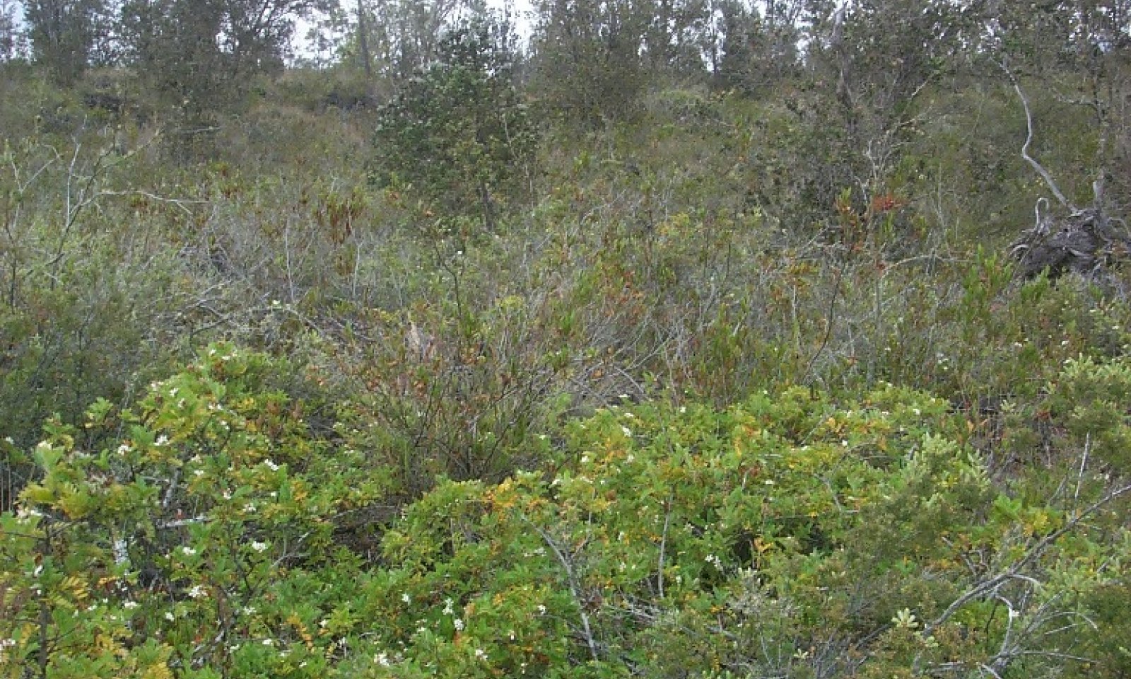
`Ohi`a lehua - alpine mirrorplant (mountain pilo)/`ulei -pukiawe/alpine hairgrass
Figure 7. Reference community phase. 5/18/07 D Clausnitzer MU166

Figure 8. More open site on Ohianui soil. 5/18/05 D Clausnitzer MU470

Figure 9. Example of sparse extreme. D Clausnitzer generic
This community phase is savanna with a sparse to open canopy of trees 25 to 50 feet (8 to 16 meters) tall and a sparse secondary canopy of trees 8 to 20 feet (2.5 to 6 meters) tall. There is a diverse understory of shrubs. Grass/grasslike canopy cover typically ranges from 5 to 10 percent.
Forest overstory.The overstory consists of primarily of ohia lehua (Metrosideros polymorpha) and, rarely, koa (Acacia koa). The secondary stratum consists of mountain pilo or alpine mirrorplant (Coprosma montana). Other small tree species, including dryland kolea (Myrsine lanaiensis), naio (Myoporum sandwicense), mamani (Sophora chrysophylla), ae or Hawaii pricklyash (Zanthoxylum hawaiiense), and mountain sandalwood (Santalum paniculatum), occur locally but are not ubiquitous across the ecological site.
Forest understory. The most abundant shrubs are pukiawe (Styphelia tameiameiae), aalii or Florida hopbush (Dodonaea viscosa), aiakanene (Coprosma ernodeoides), and ulei or Hawaii hawthorn (Osteomeles anthyllidifolia). A number of forbs, vines, and ferns are common. The most abundant grass species is alpine hairgrass (Deschampsia nubigena). Sedges are common.
Figure 10. Annual production by plant type (representative values) or group (midpoint values)
Table 5. Ground cover
Tree foliar cover 0% Shrub/vine/liana foliar cover 0% Grass/grasslike foliar cover 10-10% Forb foliar cover 0-10% Non-vascular plants 0% Biological crusts 0% Litter 10-70% Surface fragments >0.25" and <=3" 0-10% Surface fragments >3" 0-50% Bedrock 0-70% Water 0% Bare ground 0-10% Table 6. Canopy structure (% cover)
Height Above Ground (ft) Tree Shrub/Vine Grass/
GrasslikeForb <0.5 1-1% 1-1% 1-1% 1-1% >0.5 <= 1 1-1% 1-5% 1-5% 1-5% >1 <= 2 1-1% 1-5% 1-5% 1-5% >2 <= 4.5 1-1% 10-50% – – >4.5 <= 13 1-10% 1-5% – – >13 <= 40 1-15% – – – >40 <= 80 – – – – >80 <= 120 – – – – >120 – – – – Figure 11. Plant community growth curve (percent production by month). HI1612 , 161A-Isomesic ustic community growth curve. For the isomesic soil temperature regime with ustic soil moisture regime within MLRA 161A, this is a generalized growth curve for all plants..
Jan Feb Mar Apr May Jun Jul Aug Sep Oct Nov Dec J F M A M J J A S O N D 5 10 20 25 15 10 2 2 2 3 3 3 State 2
Invaded StateThis state resembles the Reference state in general structure, but some native plant species have been lost or reduced in abundance. Introduced grasses have replaced native grasses to a great extent, native ferns are much reduced in abundance, and the forb category is greater in diversity, stature, and abundance.
If fountaingrass is abundant, the risk of wildfire is greatly increased. Silk oak may be invading and becoming abundant in some areas, particularly at lower elevations of the ecological site. Introduced vines can be very invasive, covering and killing other vegetation. Vines can be kept in check by sheep; however, sheep also graze and browse native vegetation.Community 2.1
`Ohi`a lehua - alpine mirrorplant (mountain pilo)/`ulei - pukiawe/Cape ivy - crimson fountaingrass
Figure 12. Fountaingrass invaded site. 8/17/05 D Clausnitzer MU466
This community phase is savanna with a sparse to open canopy of trees 25 to 50 feet (8 to 16 meters) tall and a sparse secondary canopy of trees 8 to 20 feet (2.5 to 6 meters) tall. Abundance of native tree species in the secondary canopy may be less than that found in community phase 1.1. The shrub understory has also been diminished in abundance and diversity. Cover and diversity of grass/grasslike species and forbs is higher than in phase 2.1 due to the abundance of introduced species.
Forest overstory.The overstory consists of primarily of ohia lehua (Metrosideros polymorpha) and, rarely, koa (Acacia koa). The secondary stratum consists of mountain pilo or alpine mirrorplant (Coprosma montana). Other small tree species, including dryland kolea (Myrsine lanaiensis), naio (Myoporum sandwicense), mamani (Sophora chrysophylla), ae or Hawaii pricklyash (Zanthoxylum hawaiiense), and mountain sandalwood (Santalum paniculatum), occur locally but are not ubiquitous across the ecological site. Introduced silkoak (Grevillea robusta) may be present.
Forest understory. Native alpine hairgrass may be common, along with native Oahu sedge (Carex wahuensis) and manyspike flatsedge (Cyperus polystachyos). Introduced fountaingrass, kikuyugrass (Pennisetum clandestinum), sweet vernalgrass (Anthoxanthum odoratum), orchardgrass (Dactylis glomerata), common velvetgrass (Holcus lanatus), and other introduced grass species have more than replaced in abundance the native species that have diminished. Introduced forbs are very abundant, especially Australasian geranium (Geranium homeanum), stinking strawflower (Helichrysum foetidum), and common mullein (Verbascum thapsus). Native shrubs still are common, but some introduced species are also present. Introduced vines, especially Cape ivy (Delairea odorata), are common and very competitive with other plants.
Figure 13. Annual production by plant type (representative values) or group (midpoint values)
Table 7. Ground cover
Tree foliar cover 0% Shrub/vine/liana foliar cover 0-60% Grass/grasslike foliar cover 10-20% Forb foliar cover 0-20% Non-vascular plants 0% Biological crusts 0% Litter 10-70% Surface fragments >0.25" and <=3" 0-10% Surface fragments >3" 0-50% Bedrock 0-70% Water 0% Bare ground 0-10% Table 8. Canopy structure (% cover)
Height Above Ground (ft) Tree Shrub/Vine Grass/
GrasslikeForb <0.5 1-1% 1-60% 1-20% 1-5% >0.5 <= 1 1-1% 1-5% 1-20% 1-5% >1 <= 2 1-1% 1-5% 1-30% 1-5% >2 <= 4.5 1-1% 10-50% – 1-5% >4.5 <= 13 1-10% 1-5% – – >13 <= 40 1-15% – – – >40 <= 80 – – – – >80 <= 120 – – – – >120 – – – – Figure 14. Plant community growth curve (percent production by month). HI1612 , 161A-Isomesic ustic community growth curve. For the isomesic soil temperature regime with ustic soil moisture regime within MLRA 161A, this is a generalized growth curve for all plants..
Jan Feb Mar Apr May Jun Jul Aug Sep Oct Nov Dec J F M A M J J A S O N D 5 10 20 25 15 10 2 2 2 3 3 3 State 3
Grazed and Browsed StateThis state consists of one community phase. It occurs when introduced plant invasion, increased wildfire, and/or ungulate foraging diminish the abundance of trees and shrubs. Native trees and shrubs are particularly vulnerable to these disturbances.
Community 3.1
`Ohi`a lehua/pukiawe/Cape ivy - crimson fountaingrass
Figure 15. Degraded site. 8/17/05 D Clausnitzer MU466
This community phase is essentially an open grassland with small numbers of trees and shrubs. If fountaingrass is the dominant grass species, it is possible to lose most other species, both native and introduced, due to greatly increased wildfire.
Forest overstory.The original ohia lehua overstory may be largely intact, but over time it will diminish due to wildfire and/or reduced reproduction caused by weed competition and browsing by ungulates. Mountain pilo, mamani, and mountain sandalwood typically have been greatly reduced in abundance by browsing.
Forest understory. Introduced grass species, particularly fountaingrass and kikuyugrass, have increased greatly, while native grass abundance has been reduced. Overall grass abundance has increased greatly in comparison to the Reference or Invaded states. Introduced forbs are abundant. Abundance of most native shrub species is reduced, except possibly for aalii and pukiawe.
Figure 16. Annual production by plant type (representative values) or group (midpoint values)
Table 9. Ground cover
Tree foliar cover 0% Shrub/vine/liana foliar cover 0-10% Grass/grasslike foliar cover 20-40% Forb foliar cover 0-10% Non-vascular plants 0% Biological crusts 0% Litter 40-70% Surface fragments >0.25" and <=3" 0-10% Surface fragments >3" 0-50% Bedrock 0-70% Water 0% Bare ground 0-10% Table 10. Canopy structure (% cover)
Height Above Ground (ft) Tree Shrub/Vine Grass/
GrasslikeForb <0.5 1-1% 1-1% 1-5% 1-1% >0.5 <= 1 1-1% 1-1% 5-30% 1-5% >1 <= 2 1-1% 1-1% 50-90% 1-5% >2 <= 4.5 1-1% 1-1% – – >4.5 <= 13 1-1% – – – >13 <= 40 1-10% – – – >40 <= 80 – – – – >80 <= 120 – – – – >120 – – – – Figure 17. Plant community growth curve (percent production by month). HI1612 , 161A-Isomesic ustic community growth curve. For the isomesic soil temperature regime with ustic soil moisture regime within MLRA 161A, this is a generalized growth curve for all plants..
Jan Feb Mar Apr May Jun Jul Aug Sep Oct Nov Dec J F M A M J J A S O N D 5 10 20 25 15 10 2 2 2 3 3 3 Transition T1A
State 1 to 2This state transitions to State 2 Invaded by gradual invasion by introduced grasses and forbs.
Transition T1B
State 1 to 3This state transitions to State 3 Grazed and Browsed by reduction or loss of native species due to grazing and browsing by ungulates along with invasion by introduced plant species.
Restoration pathway R2A
State 2 to 1This state may be restored to State 1 Reference State by excluding all ungulates with a suitably designed fence. Spot weed removal must be done initially and maintained in the long term. Missing native plant species must be reintroduced.
Transition T2A
State 2 to 3State 2 Invaded can shift to State 3 Grazed and Browsed by frequent wildfires carried by introduced grasses. This is particularly true if fountaingrass (<a class="species-link" href="https://plants.usda.gov/core/profile?symbol=PESE3" target="_blank" title="Open in plants.usda.gov"><i>Pennisetum setaceum</i></a>) has invaded the plant community in State 2. This transition due to fountaingrass invasion and subsequently increased wildfire has already occurred on areas of this ecological site near Puuwaawaa cinder cone at elevations between 3500 and 4000 feet (1080 to 1230 meters). Dense fountaingrass stands of limited extent exist at elevations as high as 5200 feet (1600 meters), and the species occurs currently up to 8000 feet (2460 meters).
Restoration pathway R3A
State 3 to 1It may be possible to return this state to a semblance of State 1 Reference. However, the dry climate, typically very shallow soils, and low abundance of native shrubs and trees would make this very difficult in most areas. Fencing, removal of all ungulates, intensive and long-term weed control, and replanting of native species would be required.
Restoration pathway R3B
State 3 to 2It may be possible to return this state to a semblance of State 2 Invaded. However, the dry climate, typically very shallow soils, and low abundance of native shrubs and trees would make this very difficult in most areas. Fencing, removal of all ungulates, intensive and long-term weed control, and replanting of native species would be required.
Additional community tables
Table 11. Community 1.1 plant community composition
Group Common name Symbol Scientific name Annual production () Foliar cover (%) Grass/Grasslike1 Native bunchgrass 150–400 alpine hairgrass DENU6 Deschampsia nubigena 125–300 – hardstem lovegrass ERAT Eragrostis atropioides 10–25 – mountain lovegrass ERLE3 Eragrostis leptophylla 10–25 – pili uka TRGL3 Trisetum glomeratum 10–25 – Pacific bentgrass AGAV Agrostis avenacea 10–25 – 2 Native grasslike 50–100 Gaudichaud's sawsedge MOGA Morelotia gahniiformis 15–25 – Oahu sedge CAWA Carex wahuensis 15–25 – Hillebrand's flatsedge CYHID Cyperus hillebrandii var. decipiens 5–10 – manyspike flatsedge CYPO Cyperus polystachyos 5–10 – Hawai'i woodrush LUHA2 Luzula hawaiiensis 5–10 – Polynesian twigrush MAAN Machaerina angustifolia 5–10 – Forb6 Native herb 20–50 'uki'uki DISA6 Dianella sandwicensis 10–25 – 'ena'ena PSSA8 Pseudognaphalium sandwicensium 5–10 – pawale RUGI Rumex giganteus 5–10 – narrowleaf stenogyne STAN3 Stenogyne angustifolia 0 – 'ihi makole POSC9 Portulaca sclerocarpa 0 – 7 Native fern 10–50 alpine woodfern DRWA Dryopteris wallichiana 5–20 – black spleenwort ASAD Asplenium adiantum-nigrum 1–10 – dotted polypody POPE5 Polypodium pellucidum 5–10 – western brackenfern PTAQ Pteridium aquilinum 1–10 – Cretan brake PTCR2 Pteris cretica 1 – maidenhair spleenwort ASTR2 Asplenium trichomanes 1 – Trans-Pecos cliffbrake PETE2 Pellaea ternifolia 1 – Shrub/Vine9 Native shrub 2000–3400 Florida hopbush DOVI Dodonaea viscosa 600–1000 – pukiawe STTA Styphelia tameiameiae 600–1000 – Hawai'i hawthorn OSAN Osteomeles anthyllidifolia 600–800 – 'aiakanene COER3 Coprosma ernodeoides 50–300 – ohelo 'ai VARE Vaccinium reticulatum 25–100 – Hawai'i false ohelo WIPH2 Wikstroemia phillyreifolia 25–50 – yellow ‘ilima SIFA Sida fallax 20–50 – hinahina GECU Geranium cuneatum 10–25 – Mauna Loa beggarticks BIME Bidens menziesii 10–25 – lava dubautia DUCI Dubautia ciliolata 1–10 – alpine tetramolopium TEHU Tetramolopium humile 5–10 – pukamole LYMA3 Lythrum maritimum 1–5 – Menzies' ballart EXME Exocarpos menziesii 1–5 – Big Island ma'oloa NEOV Neraudia ovata 0 – Kauai catchfly SILA7 Silene lanceolata 0 – thorny popolo SOIN Solanum incompletum 0 – 11 Native vine 1–25 littleleaf stenogyne STMI3 Stenogyne microphylla 1–20 – ma'ohi'ohi STRU2 Stenogyne rugosa 1–5 – queen coralbead COOR11 Cocculus orbiculatus 1–5 – Tree13 Native tree 50–125 'ohi'a lehua MEPO5 Metrosideros polymorpha 50–100 – mamani SOCH Sophora chrysophylla 1–50 – alpine mirrorplant COMO3 Coprosma montana 1–25 – Lanai colicwood MYLA3 Myrsine lanaiensis 1–25 – naio MYSA Myoporum sandwicense 1–25 – mountain sandalwood SAPA7 Santalum paniculatum 1–25 – koa ACKO Acacia koa 1–25 – alpine sandmat CHOL3 Chamaesyce olowaluana 0–1 – Hawai'i pricklyash ZAHA Zanthoxylum hawaiiense 0–1 – Table 12. Community 2.1 plant community composition
Group Common name Symbol Scientific name Annual production () Foliar cover (%) Grass/Grasslike1 Native bunchgrass 5–100 alpine hairgrass DENU6 Deschampsia nubigena 5–100 – hardstem lovegrass ERAT Eragrostis atropioides 1 – mountain lovegrass ERLE3 Eragrostis leptophylla 1 – pili uka TRGL3 Trisetum glomeratum 1 – Pacific bentgrass AGAV Agrostis avenacea 1 – 2 Native grasslike 1–25 manyspike flatsedge CYPO Cyperus polystachyos 1–15 – Oahu sedge CAWA Carex wahuensis 1–5 – Gaudichaud's sawsedge MOGA Morelotia gahniiformis 1–5 – Hillebrand's flatsedge CYHID Cyperus hillebrandii var. decipiens 1 – Hawai'i woodrush LUHA2 Luzula hawaiiensis 1 – Polynesian twigrush MAAN Machaerina angustifolia 1 – 3 Exotic bunchgrass 150–500 crimson fountaingrass PESE3 Pennisetum setaceum 1–500 – sweet vernalgrass ANOD Anthoxanthum odoratum 50–150 – orchardgrass DAGL Dactylis glomerata 50–150 – common velvetgrass HOLA Holcus lanatus 50–150 – annual bluegrass POAN Poa annua 5–50 – molassesgrass MEMI2 Melinis minutiflora 5–25 – rose Natal grass MERE9 Melinis repens 5–25 – weeping grass MIST Microlaena stipoides 1–25 – smut grass SPIN4 Sporobolus indicus 5–25 – brome fescue VUBR Vulpia bromoides 1–10 – marsh bristlegrass SEPA10 Setaria parviflora 1–10 – little quakinggrass BRMI2 Briza minor 1 – 4 Exotic stoloniferous grass 1–200 kikuyugrass PECL2 Pennisetum clandestinum 1–200 – 5 Exotic grasslike 1 densetuft hairsedge BUCA2 Bulbostylis capillaris 1 – Forb6 Native herb 1 'uki'uki DISA6 Dianella sandwicensis 1 – 'ena'ena PSSA8 Pseudognaphalium sandwicensium 1 – pawale RUGI Rumex giganteus 1 – 7 Native fern 1–5 western brackenfern PTAQ Pteridium aquilinum 1–5 – Cretan brake PTCR2 Pteris cretica 1 – maidenhair spleenwort ASTR2 Asplenium trichomanes 1 – alpine woodfern DRWA Dryopteris wallichiana 1 – Trans-Pecos cliffbrake PETE2 Pellaea ternifolia 1 – dotted polypody POPE5 Polypodium pellucidum 1 – 8 Exotic herb 25–100 stinking strawflower HEFO4 Helichrysum foetidum 1–25 – common mullein VETH Verbascum thapsus 1–25 – Australasian geranium GEHO5 Geranium homeanum 1–10 – oxeye daisy LEVU Leucanthemum vulgare 1–5 – pinkhead smartweed POCA21 Polygonum capitatum 1–5 – common sheep sorrel RUAC3 Rumex acetosella 1–5 – Madagascar ragwort SEMA15 Senecio madagascariensis 1–5 – common St. Paul's wort SIOR2 Sigesbeckia orientalis 1–5 – muster John Henry TAMI3 Tagetes minuta 1–5 – bull thistle CIVU Cirsium vulgare 1–5 – lilac tasselflower EMSO Emilia sonchifolia 1–5 – southern rockbell WAMA Wahlenbergia marginata 1 – pepperweed LEPID Lepidium 1 – Shrub/Vine9 Native shrub 1800–3000 Florida hopbush DOVI Dodonaea viscosa 600–1000 – pukiawe STTA Styphelia tameiameiae 700–1000 – Hawai'i hawthorn OSAN Osteomeles anthyllidifolia 600–800 – yellow ‘ilima SIFA Sida fallax 20–50 – Hawai'i false ohelo WIPH2 Wikstroemia phillyreifolia 25–50 – 'aiakanene COER3 Coprosma ernodeoides 20–50 – ohelo 'ai VARE Vaccinium reticulatum 10–25 – hinahina GECU Geranium cuneatum 5–10 – Mauna Loa beggarticks BIME Bidens menziesii 5–10 – pukamole LYMA3 Lythrum maritimum 1–5 – lava dubautia DUCI Dubautia ciliolata 1–5 – Menzies' ballart EXME Exocarpos menziesii 1–5 – alpine tetramolopium TEHU Tetramolopium humile 1–5 – 10 Exotic shrub 50–100 spreading snakeroot AGRI2 Ageratina riparia 25–50 – Peruvian groundcherry PHPE4 Physalis peruviana 10–25 – cure for all PLCA10 Pluchea carolinensis 10–25 – 11 Native vine 1–5 littleleaf stenogyne STMI3 Stenogyne microphylla 1–5 – ma'ohi'ohi STRU2 Stenogyne rugosa 1 – queen coralbead COOR11 Cocculus orbiculatus 1 – 12 Exotic vine 1–100 Cape-ivy DEOD Delairea odorata 1–100 – banana passionflower PATRM Passiflora tripartita var. mollissima 1–25 – Mexican twist LOER3 Lophospermum erubescens 1–5 – Tree13 Native tree 50–125 'ohi'a lehua MEPO5 Metrosideros polymorpha 50–100 – mamani SOCH Sophora chrysophylla 1–50 – Lanai colicwood MYLA3 Myrsine lanaiensis 1–25 – kokea lau li'i MYSA2 Myrsine sandwicensis 1–25 – mountain sandalwood SAPA7 Santalum paniculatum 1–25 – koa ACKO Acacia koa 1–25 – alpine mirrorplant COMO3 Coprosma montana 1–25 – 14 Exotic tree 1–10 silkoak GRRO Grevillea robusta 1–10 – Table 13. Community 3.1 plant community composition
Group Common name Symbol Scientific name Annual production () Foliar cover (%) Grass/Grasslike1 Native bunchgrass 1–50 alpine hairgrass DENU6 Deschampsia nubigena 1–50 – Pacific bentgrass AGAV Agrostis avenacea 1 – 2 Native grasslike 1–5 manyspike flatsedge CYPO Cyperus polystachyos 1–5 – Oahu sedge CAWA Carex wahuensis 1 – 3 Exotic bunchgrass 1800–3400 crimson fountaingrass PESE3 Pennisetum setaceum 1800–3400 – orchardgrass DAGL Dactylis glomerata 600–1000 – common velvetgrass HOLA Holcus lanatus 600–1000 – sweet vernalgrass ANOD Anthoxanthum odoratum 500–800 – annual bluegrass POAN Poa annua 5–50 – molassesgrass MEMI2 Melinis minutiflora 10–50 – rose Natal grass MERE9 Melinis repens 10–50 – smut grass SPIN4 Sporobolus indicus 5–50 – brome fescue VUBR Vulpia bromoides 1–25 – weeping grass MIST Microlaena stipoides 10–25 – marsh bristlegrass SEPA10 Setaria parviflora 5–10 – little quakinggrass BRMI2 Briza minor 1–5 – 4 Exotic herb 100–300 kikuyugrass PECL2 Pennisetum clandestinum 200–300 – 5 Exotic bunchgrass 1 densetuft hairsedge BUCA2 Bulbostylis capillaris 1 – Forb7 Native fern 1–5 western brackenfern PTAQ Pteridium aquilinum 1–5 – Cretan brake PTCR2 Pteris cretica 1 – maidenhair spleenwort ASTR2 Asplenium trichomanes 1 – Trans-Pecos cliffbrake PETE2 Pellaea ternifolia 1 – 8 Exotic herb 10–200 stinking strawflower HEFO4 Helichrysum foetidum 1–50 – common mullein VETH Verbascum thapsus 1–50 – Madagascar ragwort SEMA15 Senecio madagascariensis 5–50 – pinkhead smartweed POCA21 Polygonum capitatum 1–10 – 'akala RUMA6 Rubus macraei 1–10 – Australasian geranium GEHO5 Geranium homeanum 1–10 – lilac tasselflower EMSO Emilia sonchifolia 1–10 – pepperweed LEPID Lepidium 1–5 – oxeye daisy LEVU Leucanthemum vulgare 1–5 – bull thistle CIVU Cirsium vulgare 1–5 – common St. Paul's wort SIOR2 Sigesbeckia orientalis 1–5 – Shrub/Vine9 Native shrub 5–250 Florida hopbush DOVI Dodonaea viscosa 1–200 – pukiawe STTA Styphelia tameiameiae 1–200 – ohelo 'ai VARE Vaccinium reticulatum 1–25 – Hawai'i false ohelo WIPH2 Wikstroemia phillyreifolia 1–25 – Hawai'i hawthorn OSAN Osteomeles anthyllidifolia 1–25 – yellow ‘ilima SIFA Sida fallax 1–25 – pukamole LYMA3 Lythrum maritimum 1–5 – 'aiakanene COER3 Coprosma ernodeoides 1–5 – 10 Exotic shrub 5–150 spreading snakeroot AGRI2 Ageratina riparia 1–100 – Peruvian groundcherry PHPE4 Physalis peruviana 1–50 – cure for all PLCA10 Pluchea carolinensis 1–50 – 11 Native vine 1 queen coralbead COOR11 Cocculus orbiculatus 1 – 12 Exotic vine 1–100 Cape-ivy DEOD Delairea odorata 1–100 – Tree13 Native tree 1–100 'ohi'a lehua MEPO5 Metrosideros polymorpha 1–100 – mamani SOCH Sophora chrysophylla 1–25 – Lanai colicwood MYLA3 Myrsine lanaiensis 1–10 – alpine mirrorplant COMO3 Coprosma montana 1–10 – 14 Exotic tree 1–25 silkoak GRRO Grevillea robusta 1–25 – Interpretations
Animal community
Wildlife
This ecological site provides habitat for the native Hawaiian hawk or io (Buteo solitarius), nene (Branta sandvicensis), and Hawaiian owl or pueo (Asio flammeus spp. sandwichensis).
A large number of native bird species have gone extinct both before and after European contact.
Introduced Wildlife
This ecological site provides habitat to a variety of introduced birds. Species such as wild turkey (Meleagris gallopavo), ring-necked pheasant (Phasianus colchicus), Erckel’s francolin (Pternistis erckelii), chuckar partridge (Alectoris chukar), and California quail (Callipepla californica) are considered to be game birds.
Feral pigs and mouflon sheep (Ovis orientalis orientalis) are common. They provide hunting opportunities but are very destructive to native vegetation. Public sport hunting typically does not have a major impact on their populations; exclusion by fences followed by intensive control measures are necessary to eliminate feral ungulates.
Introduced wildlife species are able to utilize both community phases within the ecological site.Hydrological functions
Due to the relatively dry climate and generally intact vegetation structure, runoff is not a problem.
Recreational uses
Hiking, bird watching, and hunting are recreational uses.
Wood products
There are no wood products obtained from this ecological site.
Other products
None.
Other information
Definitions
These definitions have been greatly simplified for brevity and do not cover every aspect of each topic.
Aa lava: A type of basaltic lava having a rough, jagged, clinkery surface and a vesicular interior.
Alluvial: Materials or processes associated with transportation and/or deposition by running water.
Aquic soil moisture regime: A regime in which the soil is free of dissolved oxygen because it is saturated by water. This regime typically exists in bogs or swamps.
Aridic soil moisture regime: A regime in which defined parts of the soil are, in normal years, dry for more than half of the growing season and moist for less than 90 consecutive days during the growing season. In Hawaii it is associated with hot, dry areas with plants such as kiawe, wiliwili, and buffelgrass. The terms aridic and torric are basically the same.
Ash field: a land area covered by a thick or distinctive deposit of volcanic ash that can be traced to a specific source and has well defined boundaries. The term “ash flow” is erroneously used in the Physiographic section of this ESD due to a flaw in the national database.
Ashy: A “soil texture modifier” for volcanic ash soils having a water content at the crop wilting point of less than 30 percent; a soil that holds relatively less water than “medial” and “hydrous” soils.
Available water capacity: The amount of soil water available to plants to the depth of the first root-restricting layer.
Basal area or basal cover: The cross sectional area of the stem or stems of a plant or of all plants in a stand.
Blue rock: The dense, hard, massive lava that forms the inner core of an aa lava flow.
Bulk density: the weight of dry soil per unit of volume. Lower bulk density indicates a greater amount of pore space that can hold water and air in a soil.
CaCO3 equivalent: The amount of free lime in a soil. Free lime exists as solid material and typically occurs in regions with a dry climate.
Canopy cover: The percentage of ground covered by the vertical projection downward of the outermost perimeter of the spread of plant foliage. Small openings within the canopy are included.
Community pathway: A description of the causes of shifts between community phases. A community pathway is reversible and is attributable to succession, natural disturbances, short-term climatic variation, and facilitating practices, such as grazing management.
Community phase: A unique assemblage of plants and associated dynamic soil properties within a state.
Dominant species: Plant species or species groups that exert considerable influence upon a community due to size, abundance, or cover.
Drainage class: The frequency and duration of a water table in a soil. There are seven drainage classes, ranging from “excessively drained” (soils with very rare or very deep water tables) to “well drained” (soils that provide ample water for plant growth but are not so wet as to inhibit root growth) to “very poorly drained” (soils with a water table at or near the surface during much of the growing season that inhibits growth of most plants).
Electrical conductivity (EC): A measure of the salinity of a soil. The standard unit is deciSiemens per meter (dS/m), which is numerically equivalent to millimhos per centimeter (mmhos/cm). An EC greater than about 4 dS/m indicates a salinity level that is unfavorable to growth of most plants.
Friability: A soil consistency term pertaining to the ease of crumbling of soils.
Hydrous: A “soil texture modifier” for volcanic ash soils having a water content at the crop wilting point of 100 percent or more; a soil that holds more water than “medial” or “ashy” soils.
Ion exchange capacity: The ability of soil materials such as clay or organic matter to retain ions (which may be plant nutrients) and to release those ions for uptake by roots.
Isohyperthermic soil temperature regime: A regime in which mean annual soil temperature is 72 degrees F (22 degrees C) or higher and mean summer and mean winter soil temperatures differ by less than 11 degrees F (6 degrees C) at a specified depth.
Isomesic soil temperature regime: A regime in which mean annual soil temperature is 47 degrees F (8 degrees C) or higher but lower than 59 degrees F (15 degrees C) and mean summer and mean winter soil temperatures differ by less than 11 degrees F (6 degrees C) at a specified depth.
Isothermic soil temperature regime: A regime in which mean annual soil temperature is 59 degrees F (15 degrees C) or higher but lower than 72 degrees F (22 degrees C) and mean summer and mean winter soil temperatures differ by less than 11 degrees F (6 degrees C) at a specified depth.
Kipuka: An area of land surrounded by younger (more recent) lava. Soils and plant communities within a kipuka are older than, and often quite different from, those on the surrounding surfaces.
Major Land Resource Area (MLRA): A geographic area defined by NRCS that is characterized by a particular pattern of soils, climate, water resources, and land uses. The island of Hawaii contains nine MLRAs, some of which also occur on other islands in the state.
Makai: a Hawaiian word meaning “toward the sea.”
Mauka: a Hawaiian word meaning “toward the mountain” or “inland.”
Medial: A “soil texture modifier” for volcanic ash soils having a water content at the crop wilting point of 30 to 100 percent; a soil that holds an amount of water intermediate to “hydrous” or “ashy” soils.
Naturalized plant community: A community dominated by adapted, introduced species. It is a relatively stable community resulting from secondary succession after disturbance. Most grasslands in Hawaii are in this category.
Pahoehoe lava: A type of basaltic lava with a smooth, billowy, or rope-like surface and vesicular interior.
Parent material: Unconsolidated and chemically weathered material from which a soil is developed.
Perudic soil moisture regime: A very wet regime found where precipitation exceeds evapotranspiration in all months of normal years. On the island of Hawaii, this regime is found on top of Kohala and on parts of the windward side of Mauna Kea.
pH: The numerical expression of the relative acidity or alkalinity of a soil sample. A pH of 7 is neutral; a pH below 7 is acidic and a pH above 7 is basic.
Phosphorus adsorption: The ability of soil materials to tightly retain phosphorous ions, which are a plant nutrient. Some volcanic ash soils retain phosphorus so strongly that it is partly unavailable to plants.
Reference community phase: The phase exhibiting the characteristics of the reference state and containing the full complement of plant species that historically occupied the site. It is the community phase used to classify an ecological site.
Reference state: A state that describes the ecological potential and natural or historical range of variability of an ecological site.
Restoration pathway: A term describing the environmental conditions and practices that are required to recover a state that has undergone a transition.
Sodium adsorption ratio (SAR): A measure of the amount of dissolved sodium relative to calcium and magnesium in the soil water. SAR values higher than 13 create soil conditions unfavorable to most plants.
Soil moisture regime: A term referring to the presence or absence either of ground water or of water held at a tension of less than 1500 kPa (the crop wilting point) in the soil or in specific horizons during periods of the year.
Soil temperature regime: A defined class based on mean annual soil temperature and on differences between summer and winter temperatures at a specified depth.
Soil reaction: Numerical expression in pH units of the relative acidity or alkalinity or a soil.
State: One or more community phases and their soil properties that interact with the abiotic and biotic environment to produce persistent functional and structural attributes associated with a characteristic range of variability.
State-and-transition model: A method used to display information about relationships between vegetation, soil, animals, hydrology, disturbances, and management actions on an ecological site.
Torric soil moisture regime: See Aridic soil moisture regime.
Transition: A term describing the biotic or abiotic variables or events that contribute to loss of state resilience and result in shifts between states.
Udic soil moisture regime: A regime in which the soil is not dry in any part for as long as 90 cumulative days in normal years, and so provides ample moisture for plants. In Hawaii it is associated with forests in which hapuu (tree ferns) are usually moderately to highly abundant.
Ustic soil moisture regime: A regime in which moisture is limited but present at a time when conditions are suitable for plant growth. In Hawaii it usually is associated with dry forests and subalpine shrublands.Supporting information
Type locality
Location 1: Hawaii County, HI Latitude 19° 44′ 29″ Longitude 155° 49′ 25″ General legal description This location is along the jeep trail leading south from Puuwaawaa cone. Other references
Armstrong RW. 1973. Atlas of Hawaii. University of Hawaii Press, Honolulu.
Athens JS. Ch. 12 Hawaiian Native Lowland Vegetation in Prehistory in Historical Ecology in the Pacific Islands – Prehistoric Environmental and Landscape Change. Kirch, PV and TL Hunt, eds. 1997. Yale U. Press, New Haven.
Burney DA, HF James, LP Burney, SL Olson, W Kikuchi, WL Wagner, M Burney, D McCloskey, D Kikuchi, FV Grady, R Gage II, and R Nishek. 2001. Fossil evidence for a diverse biota from Kauai and tis transformation since human arrival. Ecological Monographs 71:615-641.
Craighill ES and EG Handy. 1991. Native Planters in Old Hawaii – Their Life, Lore, and Environment. Bernice P. Bishop Museum Bulletin 233, Bishop Museum Press, Honolulu, HI
Cuddihy LW and CP Stone. 1990. Alteration of Native Hawaiian Vegetation: Effects of Humans, Their Activities and Introductions. Honolulu: University of Hawaii Cooperative National Park Resources Study Unit.
Dougill S and T Rogers. Plants of the Subalpine Forests of Mauna Kea. USGS-BRD, PIERCE, Kilauea Field Station, PO Box 44, HAVO, HI 96718
Hazlett RW and DW Hyndman. 1996. Roadside Geology of Hawaii. Mountain Press Publishing Company, Missoula MT.
Henke LA. 1929. A Survey of Livestock in Hawaii. Research Publication No. 5. University of Hawaii, Honolulu.
Jacobi JD. 1989. Vegetation Maps of the Upland Plant Communities on the Islands of Hawaii, Maui, Molokai, and Lanai. Technical Report 68. Cooperative National Park Resources Studies Unit, University of Hawaii at Manoa and National Park Service.
Kirch PV. 1982. The impact of the prehistoric Polynesians in the Hawaiian ecosystem. Pacific Science 36(1):1-14.
Kirch PV. 1985. Feathered Gods and Fishhooks: An Introduction to Hawaiian Archaeology and Prehistory. Honolulu: University of Hawaii Press.
Kirch PV. 2000. On the Road of the Winds: An Archaeological History of the Pacific Islands Before European Contact. Berkeley: University of California Press.
Little EL Jr. and RG Skolmen. 1989. Common Forest Trees of Hawaii (Native and Introduced). US Department of Agriculture-US Forest Service Agriculture Handbook No. 679. (out of print). Available at www.fs.fed.us/psw/publications/documents/misc/ah679.pdf
Loh RK. 2004. Complete vegetation map of Hawaii Volcanoes National park below 8,000 ft elevation. U.S. National Park Service.
Mueller-Dombois D and FR Fosberg. 1998. Vegetation of the Tropical Pacific Islands. Springer-Verlag New York, Inc.
Palmer DD. 2003. Hawaii’s Ferns and Fern Allies. University of Hawaii Press, Honolulu.
Pratt HD. 1998. A Pocket Guide to Hawaii’s Trees and Shrubs. Mutual Publishing, Honolulu.
Ripperton JC and EY Hosaka. 1942. Vegetation zones of Hawaii. Hawaii Agricultural Experiment Station Bulletin 89:1-60.
Rock JF. The Indigenous Trees of the Hawaiian Islands. 1st edition 1913, reprinted 1974, Charles E. Tuttle Company, Rutland, VT and Tokyo, Japan.
Shoji SD, M Nanzyo, and R Dahlgren. 1993. Volcanic Ash Soils: Genesis, Properties and Utilization. Elsevier, New York.
Sohmer SH and R Gustafson. 2000. Plants and Flowers of Hawaii. University of Hawaii Press, Honolulu.
Steadman DW. 1995. Prehistoric extinctions of Pacific island birds: biodiversity meets zooarchaeology. Science 267:1123-1131.
USDA-NRCS-PIA T&E Species GIS files. Not publicly available.
USDI-USGS. 2006. A GAP Analysis of Hawaii. Final Report and Data.
Vitousek P. 2004. Nutrient Cycling and Limitation: Hawaii as a Model Ecosystem. Princeton University Press, Princeton and Oxford.
Wagner WL, DR Herbst, and SH Sohmer. 1999. Manual of the Flowering Plants of Hawaii, Revised Edition. Bishop Museum Press, Honolulu.
Whistler WA. 1995. Wayside Plants of the Islands: a Guide to the Lowland Flora of the Pacific Islands. Isle Botanica, Honolulu.Contributors
David Clausnitzer
Loretta Metz
Joseph MayAcknowledgments
Assistance, advice, review, and/or insights: Mick Castillo Michael Constantinides, NRCS-PIA Susan Cordell, USFS Gordon Cran, Kapapala Ranch David Leonard, volunteer JB Friday, UH Forestry Extension Rick Gordon Basil Hansen, The Nature Conservancy Jennifer Higashino, USFWS and NRCS Flint Hughes, USFS Chris Jasper, NRCS Soil Survey Mel Johansen, The Nature Conservancy Kathy Kawakami, US Army Pohakuloa Training Ground Rhonda Loh, Volcanoes National Park Kamehameha Schools/Bishop Estate Miles Nakahara, Hawaii DOFAW Laura Nelson, The Nature Conservancy and NRCS Patrick Niemeyer, NRCS Soil Survey Billy Paris, rancher John Pipan Jon Price, USGS John Replogle, The Nature Conservancy Paul Scowcroft, USFS Earl Spence, grazing consultant Jim Thain Mike Tomich Quentin Tomich Tim Tunison, Volcanoes National Park Jill Wagner, consultant, Future Forests Rick Warschauer
Rangeland health reference sheet
Interpreting Indicators of Rangeland Health is a qualitative assessment protocol used to determine ecosystem condition based on benchmark characteristics described in the Reference Sheet. A suite of 17 (or more) indicators are typically considered in an assessment. The ecological site(s) representative of an assessment location must be known prior to applying the protocol and must be verified based on soils and climate. Current plant community cannot be used to identify the ecological site.
Author(s)/participant(s) Loretta J. Metz; David Clausnitzer Contact for lead author Loretta.Metz@hi.usda.gov Date 12/20/2017 Approved by Approval date Composition (Indicators 10 and 12) based on Annual Production Indicators
-
Number and extent of rills:
None -
Presence of water flow patterns:
None -
Number and height of erosional pedestals or terracettes:
None -
Bare ground from Ecological Site Description or other studies (rock, litter, lichen, moss, plant canopy are not bare ground):
1 to 10% bare ground is expected. -
Number of gullies and erosion associated with gullies:
None -
Extent of wind scoured, blowouts and/or depositional areas:
None -
Amount of litter movement (describe size and distance expected to travel):
Litter does not commonly move on this site, unless there is an rainfall event. If a heavy rainfall occurs, the smaller litter particles (eg, pukiawe and mamane leaves) may travel until they encounter a lava obstruction or rock outcrop. -
Soil surface (top few mm) resistance to erosion (stability values are averages - most sites will show a range of values):
For the volcanic ash soils on this site, the stability values will range from 1 to 3. For the organic soils on this site (highly decomposed plant materials), the stability values will range from 2 to 4. -
Soil surface structure and SOM content (include type of structure and A-horizon color and thickness):
Variable. -
Effect of community phase composition (relative proportion of different functional groups) and spatial distribution on infiltration and runoff:
There is not an appreciable difference. -
Presence and thickness of compaction layer (usually none; describe soil profile features which may be mistaken for compaction on this site):
None -
Functional/Structural Groups (list in order of descending dominance by above-ground annual-production or live foliar cover using symbols: >>, >, = to indicate much greater than, greater than, and equal to):
Dominant:
Dominant: Native shrubs = native cool-season bunchgrasses >> Sub-dominant: Native trees > native grass-likes. Other: Additional:Sub-dominant:
Other:
Additional:
-
Amount of plant mortality and decadence (include which functional groups are expected to show mortality or decadence):
Plant mortality is not frequent in these long-lived plant communities. Decadence is surprisingly low in this harsh environment. -
Average percent litter cover (%) and depth ( in):
-
Expected annual annual-production (this is TOTAL above-ground annual-production, not just forage annual-production):
Typical annual above-ground production is about 3200 lb/ac. -
Potential invasive (including noxious) species (native and non-native). List species which BOTH characterize degraded states and have the potential to become a dominant or co-dominant species on the ecological site if their future establishment and growth is not actively controlled by management interventions. Species that become dominant for only one to several years (e.g., short-term response to drought or wildfire) are not invasive plants. Note that unlike other indicators, we are describing what is NOT expected in the reference state for the ecological site:
Invasion of alien grasses and vines are the biggest threat. Refer to Plant Community 3 Plant Species Composition table in the ESD for a list of those species. -
Perennial plant reproductive capability:
Capacity to reproduce should not be reduced or impaired in the reference state.
Print Options
Sections
Font
AAAAOther
PrintThe Ecosystem Dynamics Interpretive Tool is an information system framework developed by the USDA-ARS Jornada Experimental Range, USDA Natural Resources Conservation Service, and New Mexico State University.
Accessibility statement


