
Natural Resources
Conservation Service
Ecological site R156AY230FL
Subtropical Marl Prairies of Everglades
Last updated: 4/14/2025
Accessed: 09/20/2026
-
Search


Major Land Resource Area or ecological site by name and/or ID.
PreviousSectionsNextGeneral information
Provisional. A provisional ecological site description has undergone quality control and quality assurance review. It contains a working state and transition model and enough information to identify the ecological site.
MLRA notes
Major Land Resource Area (MLRA): 156A–Florida Everglades and Associated Areas
This area makes up about 7,749 square miles (20,071 square kilometers) and is entirely in Florida. It is located at the southern tip of the State and has shoreline on both the Atlantic Ocean and the Gulf of America. Lake Okeechobee borders the MLRA to the north. Aside from sugar cane plantations in the north, the Everglades National Park, Big Cypress National Preserve, and the Big Cypress Seminole Indian Reservation comprise this area. Historical ditching, berming, and canals prevent natural water flow through this delicate ecosystem. To mitigate this, extensive restoration efforts have been implemented. Urban sprawl from Miami and cities to its north on the Atlantic Ridge has encroached along the eastern boundary of this area. Most of the MLRA has resisted urbanization because of a water table that is at or near the surface, a considerable acreage of unstable organic soils, and its identity as a national treasure.
About one-third of this area is in Native American reservations, national parks, game refuges, or other large holdings. Cypress forests are extensive in the area, but mangrove forests are widespread along the eastern and southern coasts. A large part of the area is open marsh. Much of the area is used for hunting, fishing, and other recreational activities. The cropland in the area is used mainly for winter vegetables, but citrus fruits, avocado, and papaya are grown on the better drained soils. Sugarcane is an important crop on the organic soils south of Lake Okeechobee. The acreage of improved pasture is increasing. Beef cattle are the principal kind of livestock, but dairying is an important enterprise locally. Urbanization is extensive along the eastern coast.
The major soil resource concerns are wind erosion, maintenance of the content of organic matter and productivity of the soils, and management of soil moisture and soil subsidence. Conservation practices on cropland generally include conservation crop rotations, cover crops, nutrient management, pest management, water-control structures, surface drainage systems (field ditches, mains, and laterals), pumping plants, and irrigation water management (including micro irrigation systems and surface and subsurface irrigation systems). Conservation practices on pasture and rangeland generally include prescribed grazing, brush management, pest management, prescribed burning, and watering facilities. Conservation practices on forestland generally include forest stand improvement, firebreaks, pest management, prescribed burning, and management of upland and wetland wildlife habitat.LRU notes
There is not an official LRU for the MLRA 156A area. For the time being the technical team recommended to add the four terrestrial physiographic provinces ecoregions (Big Cypress, Everglades, Southern Coast and Islands, and Miami Ridge / Atlantic Coastal Strip) and one subaqueous ecoregion (Coastal Marine and Estuarine) on this section. This PES occurs within the Everglades ecoregion.
The Everglades region, 1 to 7 m (3 to 23 ft) in elevation and begins south of Lake Okeechobee to include the Everglades Agricultural Area, the water conservation areas, and the sawgrass and sloughs of the national park. The flat plain of saw-grass marshes, tree-islands, and marsh prairies, with cropland in the north, ranges in elevation from sea level to twenty feet. Peat, muck, and some clay are the main surficial materials over the limestone. Wide sloughs, marshes, and some small ponds contain most of the surface waters in this "River of Grass" region. Canals drain much of the water in some areas.Classification relationships
All portions of the geographical range of this site falls under the following ecological / land classifications including:
-Environmental Protection Agency's Level 3 and 4 Ecoregions of Florida: 76 Southern Florida Coastal Plain; 76A Everglades (Griffith, G. E., Omernik, J. M., & Pierson, S. M., 2013)
-Florida Natural Area Inventory, 2010 Edition: Marl Prairie (FNAI ,2010)
-Soil Conservation Service, 26 Ecological Communities of Florida: 24- Sawgrass Marsh (Florida Chapter Soil and Water Conservation Society, 1989)
-Everglades National Park Ecosystems, National Park Service: Freshwater Marl Prairie (National Park Service, 2021)Ecological site concept
The Subtropical Marl Prairie of Everglades ecological community is a very poorly drained site that is seasonally inundated for three to seven months out of the year. Higher elevations support a sparsely vegetated (20 to 40% cover) and mainly graminoid- dominated communities found on organic and marl (calcium carbonate rich) substrates, with shallow depths averaging about 8 inches. Small limestone outcrops may be present in this community. Fires have an estimated return of three to fifteen years and primarily are started by lightning strikes during the summer. Fires occurring during the growing season help prevent woody succession and can carry easily through these grasslands. This ecological site occupies large areas in between cypress swamps with longer hydroperiods of six to twelve months, and pinelands or hammocks that are seldom flooded. This ecosite is found along the southeast region in the Everglades bordering the Miami Ridge/ Atlantic Coastal Strip where marl is present in the soil due to the abundance of periphyton in the soil profile.
Associated sites
R156AY220FL Subtropical Freshwater Non-Forested Glades Marshes and Slough Wetlands of Everglades
The Subtropical Freshwater Non-Forested Glades Marshes and Slough Wetlands of Everglades will occur in slightly lower landscape positions as sloughs or rises in a low broad flat. They are the dominant vegetative community in the Everglades ecoregion. Hydroperiods are longer in this community and will support a dense stand primarily of sawgrass.
F156AY210FL Subtropical Freshwater Forested Wetlands of Everglades
The Subtropical Freshwater Forested Wetlands of Everglades will occur in higher landscape position as knolls or tree islands. These communities will be forested and occur sporadically throughout the landscape as teardrop, oblate, or circular shaped islands positioned in a north to south direction due to water flow.
Similar sites
R156AY040FL Subtropical Freshwater Non-Forested Wetlands of Big Cypress
The Subtropical Freshwater Non-Forested Wetlands of Big Cypress will occur in a separate ecoregion where elevation is greater, this community is in lesser extent, and resource concerns are different and require unique management needs. Species composition and structure may be similar.
R156AY320FL Subtropical Freshwater Non-Forested Wetlands of Miami Ridge/ Atlantic Coastal Strip
The Subtropical Freshwater Non-Forested Wetlands of Miami Ridge / Atlantic Coastal Strip will occur in a separate ecoregion where elevation is greater, this community is in lesser extent, and resource concerns are different and require unique management needs. Species composition and structure may be similar.
R156AY110FL Subtropical Tidal Saline Wetlands of Southern Coast and Islands
The Subtropical Tidal Saline Wetlands of Southern Coast and Islands can be confused with the salt marsh state of the tidal wetlands. It will differ by the presence of halophytic species over regularly inundated tidal soils.
Table 1. Dominant plant species
Tree Not specified
Shrub Not specified
Herbaceous (1) Cladium mariscus ssp. jamaicense
(2) Muhlenbergia filipesPhysiographic features
These sites occur on large linear - linear and linear - concave areas that are subject to extended hydroperiods on shallow soils. In areas on exposed bedrock where limestone outcrops, locally called pinnacle rocks, are exposed through the marl soils micro-karst topography is formed.
The geology of the Everglades ecoregion falls under two separate geologic formations: the Pliocene epochs shell-bearing sediments and the most recent Pleistocene epochs Miami Limestone. These Pliocene shell-bearing sediments are complex, varying from unconsolidated, variably calcareous and fossiliferous quartz sands to well indurated, sandy, fossiliferous limestones (both marine and freshwater). Clayey sands and sandy clays are present. The Miami Limestone consists of two facies, an oolitic facies and a bryozoan facies. The oolitic facies consists of white to orangish gray, poorly to moderately indurated, sandy, oolitic limestone (grainstone) with scattered concentrations of fossils. The bryozoan facies consists of white to orangish gray, poorly to well indurated, sandy, fossiliferous limestone (grainstone and packstone). Beds of quartz sand are also present as un-indurated sediments and indurated limey sandstones. Fossils present include mollusks, bryozoans, and corals. Molds and casts of fossils are common (Scott, 2001).Table 2. Representative physiographic features
Geomorphic position, flats (1) Dip
(2) Talf
Geomorphic position, terraces (1) Tread
Slope shape across (1) Linear
Slope shape up-down (1) Linear
(2) Concave
Landforms (1) Coastal plain
(2) Marine terrace > Flat
Runoff class Very low to low Flooding frequency None Ponding duration Brief (2 to 7 days) to very long (more than 30 days) Ponding frequency Frequent Elevation 0 – 15 ft Slope 0 – 1 % Ponding depth 0 – 30 in Water table depth 0 – 12 in Aspect Aspect is not a significant factor Climatic features
The climate of MLRA 156A is subtropical, with mild winters and hot wet summers. The average annual precipitation of this MLRA is 37 to 62 inches (950 to 1,565 millimeters). About 60 percent of the precipitation occurs from June through September. Most of the rainfall occurs during moderate intensity, tropical storms that produce large amounts of rain from late spring through early autumn. Late autumn and winter are relatively dry. The average annual temperature of the MLRA is 74 to 78 degrees F (23 to 26 degrees C). The freeze-free period of the MLRA averages 355 days and ranges from 345 to 365 days.
The following tables and graphs consist of specific climate stations found within the range of this ecological site within this MLRA.Table 3 Representative climatic features
Frost-free period (characteristic range) 370 days Freeze-free period (characteristic range) 370 days Precipitation total (characteristic range) 50-60 in Frost-free period (actual range) 370 days Freeze-free period (actual range) 370 days Precipitation total (actual range) 50-60 in Frost-free period (average) 370 days Freeze-free period (average) 370 days Precipitation total (average) 60 in Characteristic rangeActual rangeBarLineFigure 1. Monthly precipitation range
Characteristic rangeActual rangeBarLineFigure 2. Monthly minimum temperature range
Characteristic rangeActual rangeBarLineFigure 3. Monthly maximum temperature range
BarLineFigure 4. Monthly average minimum and maximum temperature
Figure 5. Annual precipitation pattern
Figure 6 Annual average temperature pattern
Climate stations used
-
(1) CANAL POINT USDA [USC00081276], Belle Glade, FL
-
(2) BELLE GLADE [USC00080611], Belle Glade, FL
-
(3) SOUTH BAY 15 S [USC00088368], Southwest Palm Beach Co, FL
-
(4) TAMIAMI TRL 40 MI BEND [USC00088780], Miami, FL
-
(5) HOMESTEAD GEN AVIATION [USC00084095], Homestead, FL
-
(6) ROYAL PALM RS [USC00087760], Homestead, FL
-
(7) PERRINE 4W [USC00087020], Miami, FL
-
(8) WESTON [USC00089511], Fort Lauderdale, FL
">Influencing water features
Differences in hydroperiods are the main drives in changes in vegetation in the Everglades ecoregion, both in increased amount and in salinity levels. Marl prairies depend on a short freshwater hydroperiod of three to seven months during the rainy season and remains wet but not inundated for the remainder of the year. Longer freshwater hydroperiods favor the development of peat and dominance of sawgrass, transitioning the system to a glades marsh with marl underlying soil. Whereas shorter hydroperiods permit the invasion of woody species, transitioning the system to a shrub bog with marl underlying soil. Saltwater intrusion from the Southern Coast and Islands ecoregion has turned freshwater marl prairies into brackish salt marshes and scrub mangrove swamps as sea levels rise and overwash from large storm events. This kills the native marl prairie vegetation and shifts towards more saltwater tolerant herbaceous species with underlying marl soils.
Wetland description
Wetland Description: Cowardin<br />
System: Palustrine<br />
Subsystem: N/A<br />
Class: Emergent Wetland
Figure 7. Conceptual hydrologic system model of South Florida. Image modified from Swain et al. 2019.
Soil features
Soils associate with this ecological site occur in the isohyperthermic soil temperature regime of MLRA 156A. The isohyperthermic soil temperature regime has mean annual soil temperatures of 22 °C or more and a difference between mean summer and mean winter soil temperatures of less than 5 °C at 50 cm below the surface.
Soils in this ecological site are seasonally ponded marls or sandy marls, shallow to moderately deep, underlain by limestone. These soils are very poorly to poorly drained, neutral to slightly alkaline. It is common to find periphyton, also known as blue-green algae or cyanobacteria, on the surface of the soil as a biological crust during the dry season or attached to plants or free-floating in the water column during the wet season. Periphyton absorb acid in the water column while conducting photosynthesis and the rise in pH causes dissolved calcium in the water to solidify and build up over time, creating calcitic mud, or marl. Representative soils in this ecosite include Perrine, Pennsuco, and Biscayne.
Figure 8. Periphyton forming a biological crust in the dry season.
Table 4. Representative soil features
Parent material (1) Marl
(2) Residuum – limestone
Surface texture (1) Gravelly, marly silt
(2) Gravelly, marly silt loam
Drainage class Very poorly drained to poorly drained Permeability class Moderate Depth to restrictive layer 4 – 44 in Soil depth 4 – 44 in Surface fragment cover <=3" Not specified Surface fragment cover >3" Not specified Available water capacity
(0-44in)0.7 – 6.7 in Calcium carbonate equivalent
(0-44in)80 – 90 % Electrical conductivity
(0-44in)1 – 2 mmhos/cm Sodium adsorption ratio
(0-44in)1 – 5 Soil reaction (1:1 water)
(0-44in)7.6 – 8.2 Subsurface fragment volume <=3"
(0-44in)4 – 24 % Subsurface fragment volume >3"
(0-44in)1 % Ecological dynamics
The information presented in this ecological site description (ESD) and state-and-transition model (STM) were developed using archaeological and historical information, published and unpublished scientific reports, professional experience, consultation with technical experts, and NRCS inventories and studies. The information presented represents a complex set of plant community dynamic and environmental variables. Not all scenarios or plants are represented and included. Key indicator plants, animals, and ecological processes are described to help guide land management decisions and actions.
Marl prairie is a sparsely vegetated (20 to 40% cover), graminoid-dominated community found on marl substrates in South Florida. Scattered stunted pond cypress (Taxodium ascendens) or Slash pine (Pinus elliottii) may be present in the marl prairie. These trees are usually less than 12 feet tall with a diameter at breast height of less than 4 inches, and a canopy cover of 33% or less. Dominant herbaceous species may include one or more of the following: Gulf hairawn muhly (Muhlenbergia sericea), spreading beaksedge (Rhynchospora divergens), Florida little bluestem (Schizachyrium rhizomatum), black bogrush (Schoenus nigricans), Elliott’s lovegrass (Eragrostis elliottii), sand cordgrass (Spartina bakeri), and a short form of sawgrass (Cladium jamaicense). Other characteristic species include southern beaksedge (Rhynchospora microcarpa), bluejoint panicum (Panicum tenerum), Gulfdune paspalum (Paspalum monostachyum), rosy camphorweed (Pluchea rosea), starrush whitetop (Rhynchospora colorata), alligatorlily (Hymenocallis palmeri), arrowfeather threeawn (Aristida purpurascens), and narrowleaf yellowtops (Flaveria linearis).
Periphyton, or cyanobacteria, is the primary source for the marl substrates, covering large patches and often forming a thick biological crust. Not only are they primary producers, using photosynthesis to grow and create oxygen, but are important to the food web, being consumed by snails, frogs, aquatic insects, and fish. When periphyton conducts photosynthesis, it consumes acids in the water column. The acid in the water column is removed and the pH of the water increases. This increase in pH causes dissolved calcium in the water to solidify on the surface of periphyton, other plants, or rocks. It is calcium that gives periphyton its gray or yellow-brown color. During the dry season, the organic material in the periphyton is eaten by small invertebrates, but the calcium remains behind. Over time, this calcium builds up on the ground and creates a soil that is called marl (also called calcitic mud) (NPS, 2020). These organisms serve as natural and historic indicators of this ecosystem’s health. They are easily affected by changes in the environment, and if nutrient levels such as phosphorus become too high, they are outcompeted by cattails (Typha spp.), as well as remaining in the soil profile which can show historical water and nutrient conditions.
Marl prairies are similar to wet prairies in their species composition but are distinguished by extensive outcrops of limestone exposed at the surface and the presence of marl instead of mineral soil. These are diverse communities which may contain over 100 species, but most of these species contribute little cover whereas most of the cover is provided by only two or three dominant species mentioned above. The main distinguishing feature of this community is the presence of marl in the soil and shallow depths to limestone, which are highly alkaline and impermeable, which causes water to pond during the wet season.
This ecosite depends on a short hydroperiod of three to seven months. Longer hydroperiods favor the development of peat and the dominance of sawgrass and transition back to a freshwater marsh ecosystems; shorter hydroperiods permit the invasion of woody species to shrub bogs. Marl prairie normally dries out during the winter and is subject to fires at the end of the dry season (May to June), aiding the building process of calcitic mud or marl. Fires at this time (in contrast to dormant season fires) stimulate flowering of the dominant grasses as well as acting to exclude woody species development. The herbaceous species recover rapidly from fire and biomass reaches pre-fire levels at the end of two years. For the first two years after a fire this community will burn only patchily, if at all (Burch, 2003). Under drought conditions, wildfires may burn down the peat layer, destroying plant roots and seedbeds and converting these areas to lower elevation communities and sloughs which may hold standing water. Reasons for the presence of dwarf cypress in some marl prairies and not others are not yet known.
This community tends to be dominant in the southeast region of the Everglades ecoregion (area south of Homestead), and also present along the southwest border with Big Cypress. It is a globally impaired community. Rock plowing is one of the greatest threats, converting the area into agricultural fields or for urban development, making the area unable to revert back to its original state.State and transition model
More interactive model formats are also available. View Interactive Models
Click on state and transition labels to scroll to the respective textEcosystem states
States 1, 5 and 2 (additional transitions)
T1A - Increase in Long-Term Freshwater Hydroperiod T1B - Invasion of Non-Native / Exotic Species T1C - Modified for Desired Land Use T1D - Human Alteration / Transportation of Materials T2A - Invasion of Non-Native / Exotic Species T2B - Modify for Desired Land Use T2C - Human Alteration / Transportation of Materials R3A - Mechanical / Biological / Chemical Removal of Species R3B - Mechanical / Biological / Chemical Removal of Species T3A - Modify for Desired Land Use T3B - Human Alteration / Transportation of Materials R4A - Landscape and Habitat Restoration R4B - Landscape and Habitat Restoration R4C - Landscape and Habitat Restoration T4A - Human Alteration / Transportation of Materials State 1 submodel, plant communities
1.1A - Absence of Fire 1.2A - Shrub Removal / Reintroduction of Fire State 2 submodel, plant communities
2.1A - Increase in Long-Term Hydroperiod State 4 submodel, plant communities
Communities 2 and 5 (additional pathways)
4.1A - Land Clearing Practices 4.2A - Habitat Restoration 4.2B - Pasture Preparation 4.2C - Agricultural Preparation 4.2D - Silvicultural Preparation 4.3A - Land Clearing Practices 4.3B - Agricultural Preparation 4.3C - Silvicultural Preparation 4.4A - Land Clearing Practices 4.4B - Silvicultural Preparation 4.5A - Land Clearing Practices State 5 submodel, plant communities
5.1A - Urban Development 5.1B - Waste Accumulation 5.2A - Land Reclamation 5.2B - Industrial / Urban Development 5.2C - Waste Accumulation 5.3A - Land Reclamation State 1
Marl PrairieMarl prairies are sparsely vegetated, graminoid dominated communities found on marl substrates in the Everglades ecoregion of South Florida. Periphyton function within this ecological site to precipitate calcium carbonate to form marl substrates found within the soil profile and on the surface. Stunted trees may be present within this community.
Characteristics and indicators. Marl is the primary indicator of this ecological site, formed by blue-green algae species known as periphyton.
Resilience management. Fire is used to maintain this community, estimated at intervals of every 3 to 15 years. This helps prevent invasion from woody species and help stimulate flowering plants, with fires taking place during the winter months. Maintenance of the hydroperiod is also plays an important role. This site has a hydroperiod of 3 to 7 months which helps maintain grasses and herbaceous species being dominant. Alteration of the natural hydroperiod, whether increases or decreases, or changes in salinity, will alter the reference state.
Dominant resource concerns
-
Wind erosion
-
Subsidence
-
Organic matter depletion
-
Ponding and flooding
-
Seasonal high water table
Community 1.1
Freshwater Marl PrairieFreshwater marl prairies are sparsely vegetated, graminoid-dominated communities found on marl substrates influenced primarily by freshwater. Periphyton function to precipitate calcium carbonate to form marl substrates, often found within the soil profile and throughout the prairie on rocks and grasses. This allows for slow permeability through the soil which creates slightly longer hydroperiods than wet prairies, but shorter than freshwater marshes and sloughs. These are highly diverse communities, and can support many herbaceous species while having the majority of the plant cover being two or three different grass species.
Resilience management. Fire is used to sustain this community, with return intervals every 3 to 15 years to maintain structure and prevent woody invasion. These prairies usually dry out in the winter and is subject to fire before the growing season in the spring, which help stimulate flowering of dormant grasses.
Dominant plant species
-
pond cypress (Taxodium ascendens), tree
-
Florida slash pine (Pinus elliottii var. densa), tree
-
gulfhairawn muhly (Muhlenbergia filipes), grass
-
beaksedge (Rhynchospora), grass
-
little bluestem (Schizachyrium), grass
-
black bogrush (Schoenus nigricans), grass
-
lovegrass (Eragrostis), grass
-
cordgrass (Spartina), grass
-
Jamaica swamp sawgrass (Cladium mariscus ssp. jamaicense), grass
-
arrowfeather threeawn (Aristida purpurascens), grass
-
bluejoint panicgrass (Panicum tenerum), grass
-
gulfdune paspalum (Paspalum monostachyum), other herbaceous
-
rosy camphorweed (Pluchea rosea), other herbaceous
-
alligatorlily (Hymenocallis palmeri), other herbaceous
-
narrowleaf yellowtops (Flaveria linearis), other herbaceous
Community 1.2
Shrub bogShrub bogs consists of dense stands of broadleaf evergreen shrubs, vines, and short trees, with height dependent on time since fire, with or without an overstory of scattered pine or bay trees, growing in mucky soil where water is usually less than a foot deep. These communities become formed when fire is excluded from the reference communities for a long period of time (estimated more than 15 years), which allow for the establishment of woody species. Fires tend to extinguish themselves from this community, and are often found adjacent to freshwater marshes or other wetlands. The larger the shrub species are the longer without fire this community has gone. Within marl prairies these shrub bogs may form when there has been a decrease in freshwater hydrology through urbanization and fire has been excluded from the system. This will allow for the growth of shrubby species to become established.
Resilience management. This community is maintained by the absence of fire within a community which allows for the establishment of organic matter accumulation and shrub growth. Excluding fire from this community maintains this structure. When fires do occur in this community, it is during periods of extreme drought, in which the shrubs are able to re-sprout rapidly.
Dominant plant species
-
Florida slash pine (Pinus elliottii var. densa), tree
-
pond cypress (Taxodium ascendens), tree
-
red maple (Acer rubrum), tree
-
fetterbush lyonia (Lyonia lucida), shrub
-
large gallberry (Ilex coriacea), shrub
-
inkberry (Ilex glabra), shrub
-
wax myrtle (Morella cerifera), shrub
-
Virginia sweetspire (Itea virginica), shrub
-
myrtle dahoon (Ilex myrtifolia), shrub
-
sweetbay (Magnolia virginiana), shrub
-
swamp bay (Persea palustris), shrub
-
greenbrier (Smilax), other herbaceous
-
pipewort (Eriocaulon), other herbaceous
-
leatherfern (Acrostichum), other herbaceous
-
airplant (Tillandsia), other herbaceous
-
sphagnum (Sphagnum), other herbaceous
Pathway 1.1A
Community 1.1 to 1.2This mechanism that drives the change from a prairie to a shrub bog consists of the absence of fire from the community which allows organic matter accumulation and the establishment of woody shrub species. Introduction of species may be from wildlife, introduction anthropogenically, or from encroachment of surrounding communities.
Context dependence.This is dependent of the absence of fire from this community which can allow the accumulation of organic matter and growth of shrubby species. It is estimated for the transition fire must be excluded from this community more than 15 years, which is sufficient amounts of time to allow for woody growth. Absence of fire may be from poor management, anthropogenic firebreaks that block natural fires, or unusually wet years.
Pathway 1.2A
Community 1.2 to 1.1The transition back to a marl prairie includes the removal of shrubs. This may be achieved by reintroducing fire back into the system along the proper intervals. It may also be achieved by mechanical, chemical, or biological removal of undesirable shrubby species. Fire reintroduction will be needed if mechanical, chemical, or biological methods are utilized to remove excessive organic matter buildup already present in the system.
State 2
Freshwater MarshThis state is characterized by a long hydroperiod (>7 months) and is dominated by grasses, sedges, broadleaf emergent, floating aquatics, or shrubs. Species composition usually is heterogeneous and forms along different zones related to length of hydroperiod and depth of flooding. These marshes are often the result of marl prairies which have experienced an increase in its long-term hydroperiod, promoting organic matter accumulation and sawgrass development. These can be characterized as sawgrass marshes found on organic soils over calcitic soils.
Dominant resource concerns
-
Wind erosion
-
Subsidence
-
Organic matter depletion
-
Concentration of salts or other chemicals
-
Seasonal high water table
-
Nutrients transported to surface water
-
Plant productivity and health
-
Plant structure and composition
-
Aquatic habitat for fish and other organisms
Community 2.1
Marly Glades Marsh
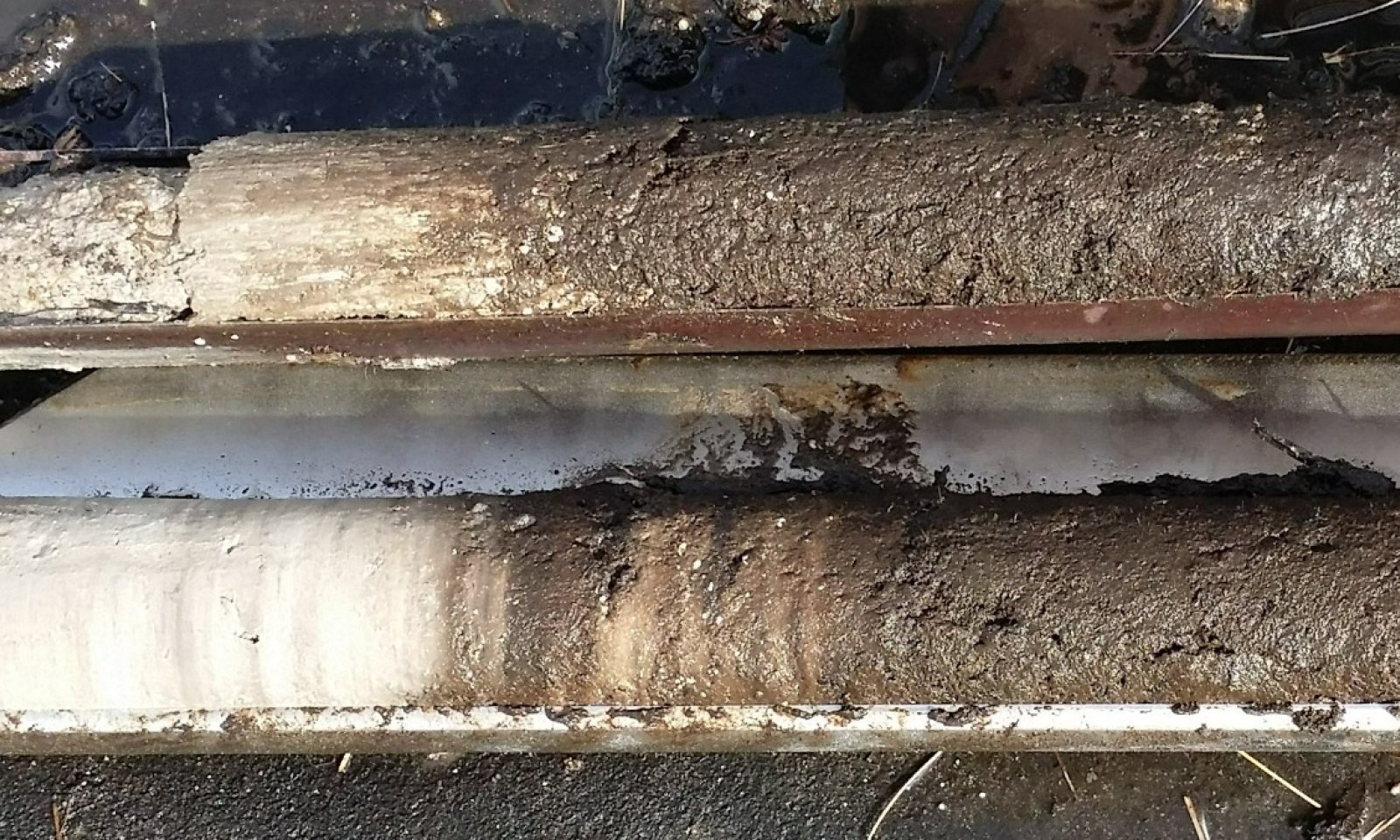
Figure 9. Close up of soil core from the Everglades ecoregion showing a layer of marl (left) under highly decomposed organic material (right). The vegetation currently represents a sawgrass marsh, but shows evidence of once of marl prairie origin.
This community is representative of the sawgrass marshes similar to the Non-Forested Glades Marsh and Slough Wetlands of Everglades concept (R156A220FL). These are sawgrass dominated marshes found on organic soils over a marl substrate.
Dominant plant species
-
Jamaica swamp sawgrass (Cladium mariscus ssp. jamaicense), grass
Community 2.2
Open WaterThis community is formed from long hydroperiods that can cause permanent flooding in a given area, destroying the reference site and creating a permanently flooded waterbody. Emergent aquatic vegetation may occur within this area.
Dominant plant species
-
American white waterlily (Nymphaea odorata), other herbaceous
-
bladderwort (Utricularia), other herbaceous
-
pickerelweed (Pontederia cordata), other herbaceous
-
bulltongue arrowhead (Sagittaria lancifolia), other herbaceous
-
bent alligator-flag (Thalia geniculata), other herbaceous
Pathway 2.1A
Community 2.1 to 2.2This driver stems from increased freshwater hydroperiods, whether natural or anthropogenic. Natural increases in hydroperiods may be due to increased precipitation over a decadal scale or changes in sea level rise. Anthropogenic increases in hydroperiods may be from urbanization further up the watershed, which may lead to increased sheet flow or longer standing water.
State 3
Invasive Non-Native CommunityThis state consists of Florida Department of Agriculture and Consumer Services (FDACS) Non-Native Category 1 Species list . More information on these species list can be found:
https://www.fdacs.gov/content/download/63140/file/Florida%E2%80%99s_Pest_Plants.pdf
or by contacting the UF / IFAS Center for Aquatic and Invasive Plants (http://plants.ifas.ufl.edu/),
the UF / IFAS Assessment of Non-native Plants in Florida's Natural Areas (https://assessment.ifas.ufl.edu/),
or the FWC Invasive Plant Management Section (http://myfwc.com/wildlifehabitats/invasive-plants/).
This community will not represent every possibility of invasive species but rather the most common in these areas.
Characteristics and indicators. Non-native species include species that exist outside of Florida's natural range and introduced to the state by people, weather, or any other means.
Resilience management. This state can be found as a part of any other state and can completely destroy the native habitat if not properly managed. Restoration to natural communities after exotic invasion include practices such as mechanical, biological, and chemical removals.
Dominant resource concerns
-
Subsidence
-
Concentration of salts or other chemicals
-
Nutrients transported to surface water
-
Plant productivity and health
-
Plant structure and composition
State 4
Managed Resource AreasThe following communities comprise the major land uses in the United States and the land uses receiving the majority of the conservation treatment that address soil, water, air, plant, and animal resources within the USDA.
Characteristics and indicators. These land uses consist of areas that are not completely naturalized (i.e. native habitat) but are not completely altered by anthropogenic means.
Dominant resource concerns
-
Compaction
-
Ponding and flooding
-
Seasonal high water table
-
Emissions of greenhouse gases (GHGs)
-
Objectionable odors
-
Plant productivity and health
-
Plant structure and composition
Community 4.1
RangelandRangelands are described as lands on which the indigenous vegetation is predominately grasses, grass-like plants, forbs, and possibly shrubs or dispersed trees. Existing plant communities can include both native and introduced plants. Primary export from Florida ranges are cattle and have been present in the state since their first introduction by Spanish explorers in 1521. This is the reference community for this state because it requires very little alterations to the landscape for grazing species.
Rangelands provide a diversity of ecosystems and also provide a diverse and significant production of economic benefits and ecosystem goods and services. Livestock production along with sustainable wildlife populations provide for the major direct economic benefits, but also tourism, recreational uses, minerals/energy production, renewable energy, and other natural resource uses can be very significant. Vital ecosystem contributions include clean water, clean air, fish/wildlife habitat, as well as intangible considerations such as historical, cultural, aesthetic and spiritual values.
Resilience management. Grazing, by both domestic livestock and wildlife, is the most common ecological management process, with fire and weather extremes also being significant ecological factors. For information regarding specific cattle grazing techniques please contact your local NRCS office.
Community 4.2
Open Transitional Managed CommunitiesThis is an area that is managed to maintain open land before shifting to another community. These communities are often used as transitional periods from one practice to another and could lead to an abandoned / fallow field.
Community 4.3
Improved PasturePasture is a land use type having vegetation cover comprised primarily of introduced or enhanced native forage species that is used for livestock grazing. Pasture vegetation can consist of grasses, legumes, other forbs, shrubs or a mixture. The majority of these forages are introduced, having originally come from areas in other states or continents. Most are now naturalized and are vital components of pasture based grazing systems.
Pasture lands provide many benefits other than forage for livestock. Wildlife use pasture as shelter and for food sources. Well managed pasture captures rainwater that is slowly infiltrated into the soil which helps recharge groundwater. Many small pasture livestock operations are near urban areas providing vistas for everyone to enjoy.
Resilience management. Pastures receive periodic renovation and cultural treatments such as tillage, fertilization, mowing, weed control, and may be irrigated. For more information regarding specific pasture management please contact your local NRCS office.
Community 4.4
AgricultureThe agriculture industry includes cultivated crops, aquaculture, and apiculture. Cultivated cropland includes areas used for the production of adapted crops for harvest. These areas comprises land in row crops or close-grown crops that are in a rotation with row or close-grown crops. Primary export from Florida consists of fruits, greenhouse and nursery products, sugar cane, and the signature export of citrus. Aquaculture includes the cultivation and maintenance of aquatic plants, aquatic reptiles, crustaceans, food/ ornamental fish, shellfish, and other miscellaneous species for harvesting. Apiculture includes the maintenance of honeybees and hives to provide beeswax, honey/ other edible bee products, crop pollination services, and sales of bees to other beekeepers. These areas have been modified resulting in land clearing practices and hydrologic management to fit the growers needs.
Resilience management. Major natural resource concerns facing cropland include: (1) erosion by wind and water, (2) maintaining and enhancing soil quality, (3) water quality from nutrient and pesticides runoff and leaching, and (4) managing the quantity of water available for irrigation. For more specific information regarding cropland please contact your local NRCS office.
Community 4.5
SilvicultureSilviculture is land used in controlling the establishment, growth, composition, health, and quality of forests and woodlands to meet the diverse needs and values of landowners and society such as wildlife habitat, timber, water resources, restoration, and recreation on a sustainable basis. These are forestry practices that include thinning, harvesting, planting, pruning, prescribed burning and site preparation, for managed goals such as wildlife habitat creation or harvesting. Many managed silvicultural lands in Florida include tree plantations for growth of tropical ornamental species such as palms; and lumber, pulp, and paper species such as slash pine, longleaf pine, cypress, and eucalyptus.
This community also include management practices of agroforestry, the intentional mixing
of trees and shrubs into crop and/or animal production systems to create environmental, economic and social benefits. This is included in this community and not any other state because the primary management is for tree species. This may include practices such as riparian forest buffers, windbreaks, forest farming, silvopasture, and alley cropping.
Resilience management. Management of silvicultural lands require specific prescriptions based on the management goals for the stand, and may include thinning, harvesting, planting, pruning, prescribed burning and site preparation. For more information regarding specific management for silviculture practices please contact your local NRCS office.
Pathway 4.1A
Community 4.1 to 4.2This pathway is driven by land clearing practices that consists of removing the existing vegetation from the habitat and altering the habitat to prepare for modified land use.
Pathway 4.2A
Community 4.2 to 4.1This pathway is driven by the restoration of the native habitat for the use of rangeland. This includes restoration of both the hydrology and landscape in advance of replanting native species. This is a time-consuming process and often results in second-hand community structure. Once restored to a natural capacity the introduction of grazing species to the system creates a managed rangeland.
Pathway 4.2B
Community 4.2 to 4.3This pathway is driven by preparing the land for pasteurization. This includes the planting of vegetation consisting of grasses, legumes, other forbs, shrubs or a mixture that will provide preferred forage for managed grazing species.
Pathway 4.2C
Community 4.2 to 4.4This pathway is driven by the preparation of land for agricultural uses. This change is dependent on the type of agricultural community is being created, but often depends on the growing, maintenance, and cultivation of an agricultural product for consumers. This community may require modification to the land to fit the hydrologic requirement of the growing crop.
Pathway 4.2D
Community 4.2 to 4.5This pathway is driven by the preparation of the land for silvicultural purposes. This change is dependent on the type of silvicultural product being cultivated, as many different practices require different growth requirements.
Pathway 4.3A
Community 4.3 to 4.2This pathway is driven by land clearing practices that consists of removing the existing vegetation from the habitat and altering the habitat to prepare for modified land use.
Pathway 4.3B
Community 4.3 to 4.4This pathway is driven by the preparation of land for agricultural uses. This change is dependent on the type of agricultural community is being created, but often depends on the growing, maintenance, and cultivation of an agricultural product for consumers. This community may require modification to the land to fit the hydrologic requirement of the growing crop.
Pathway 4.3C
Community 4.3 to 4.5This pathway is driven by the preparation of the land for silvicultural purposes. This change is dependent on the type of silvicultural product being cultivated, as many different practices require different growth requirements.
Pathway 4.4A
Community 4.4 to 4.2This pathway is driven by land clearing practices that consists of removing the existing vegetation from the habitat and altering the habitat to prepare for modified land use.
Pathway 4.4B
Community 4.4 to 4.5This pathway is driven by the preparation of the land for silvicultural purposes. This change is dependent on the type of silvicultural product being cultivated, as many different practices require different growth requirements.
Pathway 4.5A
Community 4.5 to 4.2This pathway is driven by land clearing practices that consists of removing the existing vegetation from the habitat and altering the habitat to prepare for modified land use.
State 5
Human Altered and Human Transported AreasThese areas include soils that were intentionally and substantially modified by humans for an intended purpose, commonly for terraced agriculture, building support, mining, transportation, and commerce. The alteration is of sufficient magnitude to result in the introduction of a new parent material (human-transported material) or a profound change in the previously existing parent material (human-altered material). They do not include soils modified through standard agricultural practices or formed soils with unintended wind and water erosion. When a soil is on or above an anthropogenic landform or microfeature, it can be definitely be associated with human activity and is assigned to a unique taxa, usually found as an "Urban land complex" within that communities' natural soil properties (e.g., Biscayne gravelly marly silt loam, drained-Urban land complex, 0-1% slopes).
Characteristics and indicators. Evidence of these areas include soils with manufactured items (e.g. artifacts) present in the profile, human altered-materials (e.g., deeply excavated or deeply plowed soil) or human-transported material (e.g., fill), and position on or above anthropogenic landforms (e.g., flood-control levees) and microfeatures (e.g., drainage ditches). Detailed criteria regarding the identification of anthropogenic (artificial) landforms, human-altered materials, and human-transported material are in the "Keys to Soil Taxonomy" (Soil Survey Staff, 2014).
Dominant resource concerns
-
Organic matter depletion
-
Concentration of salts or other chemicals
-
Ponding and flooding
-
Seasonal high water table
-
Surface water depletion
-
Ground water depletion
-
Petroleum, heavy metals, and other pollutants transported to surface water
-
Petroleum, heavy metals, and other pollutants transported to ground water
-
Emissions of greenhouse gases (GHGs)
-
Objectionable odors
-
Plant productivity and health
-
Plant structure and composition
Community 5.1
Reclaimed AreasReclaimed areas are areas that have been modified through anthropogenic means that are restored to a natural or second-hand natural community. Areas that can be reclaimed are any intensity urban areas, and may be required to be reclaimed after urban use (e.g., active mines must be reclaimed). These practices include the identification, removal, and stockpiling soil materials before altering the land, and revegetation and replacement of soil materials after altering the land. This also applies to nearby urban areas that have been adversely affected by the anthropogenic activities.
Community 5.2
UrbanThis urban community consists of development for human use. Urban areas include a variety of land uses, e.g., inner city or urban core, industrial and residential areas, cemeteries, parks, and other open spaces; the overall function which may benefit the quality of human life. These often form an urban soil mosaic, where the natural landscape has been fragmented into parcels with distinctive disturbance and management regimes and, as a result, distinctive characteristic soil properties.
Within this community there are three different levels of urbanization, based off population dynamics, residential density, and intensity of development. These are labeled as low-intensity, medium-intensity, and high-intensity urban areas, which can eventually be split apart into its own separate state. Low-intensity urban areas may consist of single dwelling homes with little impact on the surrounding community which still somewhat represents the natural community (e.g., represents natural landscape, hydrology, and vegetation) , other examples of this are urban parks, cemeteries, or campgrounds with little urban development. Medium-intensity urban areas consist of larger urban dwellings with some natural features, but have been modified to meet urban needs (e.g., towns). High-intensity urban areas are areas of heavily modified areas with complete alterations of the natural landscape, hydrology, and vegetation to support a very large population, which once constructed is permanently altered (e.g., metropolis areas/ active mines).Community 5.3
Non-Reclaimed AreasNon-reclaimed areas are areas that have been modified through anthropogenic means that are unable to be restored to a natural or second-hand natural community. Areas that cannot be reclaimed are areas under active mining status or mined areas before the Phosphate Land Reclamation Act in 1975, which leaves shut down operations alone. These areas also include fallow mines that have been flooded and are now permanent bodies of water.
Community 5.4
LandfillsThis is an anthropogenic site for the disposal of waste material. It includes manufactured layers (artificial, root limiting layer below the soil surface) that are representative of human altered and human transported sites. These layers are often alternative between natural fill material and geotextile liners, asphalt, concrete, rubber or plastic that are built up and can rise above the surrounding landscape by 30 meters or more often impeding water, gas, or roots from moving through the profile.
Pathway 5.1A
Community 5.1 to 5.2This shift in communities is driven by clearing and developing the land for the desired community.
Pathway 5.1B
Community 5.1 to 5.4This transition is driven by the deposition of manufactured layers along with anthropogenic waste which is consistently built upon.
Pathway 5.2A
Community 5.2 to 5.1This transition is driven by the revegetation, reestablished hydrology, and replacement of displaced soil materials after altering the land.
Pathway 5.2B
Community 5.2 to 5.3This transition is driven from heavy industrial or urban development which causes the land to become non-reclaimable. This transition is rare due to the many environmental laws and regulations that must be followed when developing.
Pathway 5.2C
Community 5.2 to 5.4This transition is driven by the deposition of manufactured layers along with anthropogenic waste which is consistently built upon.
Pathway 5.3A
Community 5.3 to 5.1This transition is driven by the revegetation, reestablished hydrology, and replacement of displaced soil materials after altering the land.
Transition T1A
State 1 to 2Longer hydroperiods can transition this community to freshwater marshes favoring peat development. Occurrence of this transition can be natural over extended periods of time or may be through anthropogenic alterations of the surrounding landscape which may alter the natural hydroperiod of these communities.
Transition T1B
State 1 to 3The invasion of non-native or exotic species can be driven by a multitude of different environmental factors such as changes in natural hydroperiods or in fire regimes. Typically once a change in one of the two factors mentioned above occurs, non-native or exotic invasive species become established and begin to compete with native species for habitat and nutrients.
Constraints to recovery.Recovery from non-native or exotic invasive species may be difficult due to many adaptations which allow them to outcompete and survive in altered conditions. Localized knowledge for each species must be known for best removal of it without harming the native environment, and often different treatments must be applied over one given area.
Context dependence.Growth of non-native and exotic invasive species can be rapid following a change in a natural stressor such as fire frequency or natural hydroperiods which might have once kept the invasive species at bay.
Transition T1C
State 1 to 4Modify the land for the desired land use. This may include the establishment of grazing species or the modification of land for the cultivation of crops of other desired products. Due to the shallow nature of this ecosite, the development of these areas utilize rock plowing, a process that breaks the limestone bedrock to establish deeper soils used for agriculture and planting species.
Transition T1D
State 1 to 5This transition is driven by the alteration and/ or transportation of materials via anthropogenic means.
Transition T2A
State 2 to 3The invasion of non-native or exotic species can be driven by a multitude of different environmental factors such as changes in natural hydroperiods or in fire regimes. Typically once a change in one of the two factors mentioned above occurs, non-native or exotic invasive species become established and begin to compete with native species for habitat and nutrients.
Constraints to recovery.Recovery from non-native or exotic invasive species may be difficult due to many adaptations which allow them to outcompete and survive in altered conditions. Localized knowledge for each species must be known for best removal of it without harming the native environment, and often different treatments must be applied over one given area.
Context dependence.Growth of non-native and exotic invasive species can be rapid following a change in a natural stressor such as fire frequency or natural hydroperiods which might have once kept the invasive species at bay.
Transition T2B
State 2 to 4Modify the land for the desired land use. This may include the establishment of grazing species or the modification of land for the cultivation of crops of other desired products.
Transition T2C
State 2 to 5This transition is driven by the alteration and/ or transportation of materials via anthropogenic means.
Restoration pathway R3A
State 3 to 1Mechanical, biological, and chemical removal strategies include removing the non-native and exotic invasive species through various mechanisms. Localized knowledge for individual non-native or exotic invasive species is needed for specific management. Sometimes introduction of fire regimes may prevent or stop the growth of non-native or exotic invasive species, but many species are fire tolerant. Mechanical removal might include cutting and removal of invasive species. Chemical removal might include spot spraying or basal bark injection treatments.
Context dependence.Mechanical, biological, and chemical removal of non-native and exotic invasive species is a time dependent process, with both removal types taking long times to be considered effective.
Restoration pathway R3B
State 3 to 2Mechanical, biological, and chemical removal strategies include removing the non-native and exotic invasive species through various mechanisms. Localized knowledge for individual non-native or exotic invasive species is needed for specific management. Sometimes introduction of fire regimes may prevent or stop the growth of non-native or exotic invasive species, but many species are fire tolerant. Mechanical removal might include cutting and removal of invasive species. Chemical removal might include spot spraying or basal bark injection treatments.
Context dependence.Mechanical, biological, and chemical removal of non-native and exotic invasive species is a time dependent process, with both removal types taking long times to be considered effective.
Transition T3A
State 3 to 4Modify the land for the desired land use. This may include the establishment of grazing species or the modification of land for the cultivation of crops of other desired products.
Transition T3B
State 3 to 5This transition is driven by the alteration and/ or transportation of materials via anthropogenic means.
Restoration pathway R4A
State 4 to 1These practices include the restoration of both the natural hydroperiods and landscape in advance of revegetating the area (if needed).
Restoration pathway R4B
State 4 to 2These practices include the restoration of both the natural hydroperiods and landscape in advance of revegetating the area (if needed).
Restoration pathway R4C
State 4 to 3These practices include the restoration of both the natural hydroperiods and landscape in advance of revegetating the area (if needed).
Transition T4A
State 4 to 5This transition is driven by the alteration and/ or transportation of materials via anthropogenic means.
Additional community tables
Table 5. Community 1.1 plant community composition
Group Common name Symbol Scientific name Annual production () Foliar cover (%) Table 6. Community 1.2 plant community composition
Group Common name Symbol Scientific name Annual production () Foliar cover (%) Table 7. Community 2.1 plant community composition
Group Common name Symbol Scientific name Annual production () Foliar cover (%) Table 8. Community 2.2 plant community composition
Group Common name Symbol Scientific name Annual production () Foliar cover (%) Table 9. Community 4.1 plant community composition
Group Common name Symbol Scientific name Annual production () Foliar cover (%) Table 10. Community 4.2 plant community composition
Group Common name Symbol Scientific name Annual production () Foliar cover (%) Table 11. Community 4.3 plant community composition
Group Common name Symbol Scientific name Annual production () Foliar cover (%) Table 12. Community 4.4 plant community composition
Group Common name Symbol Scientific name Annual production () Foliar cover (%) Table 13. Community 4.5 plant community composition
Group Common name Symbol Scientific name Annual production () Foliar cover (%) Table 14. Community 5.1 plant community composition
Group Common name Symbol Scientific name Annual production () Foliar cover (%) Table 15. Community 5.2 plant community composition
Group Common name Symbol Scientific name Annual production () Foliar cover (%) Table 16. Community 5.3 plant community composition
Group Common name Symbol Scientific name Annual production () Foliar cover (%) Table 17. Community 5.4 plant community composition
Group Common name Symbol Scientific name Annual production () Foliar cover (%) Interpretations
Animal community
This community provides little cover and forage for many animal species that depend on shorter hydroperiods and fire return intervals for nesting. Periphyton acts as an important food source for the invertebrates, tadpoles, and some fish that might habitat this area during the wet season and thus serve as a food source for predator species such as birds of prey or mammals and reptiles. Common species include:
Mammals: Southern mink (southern Florida population; Mustela vision mink), Florida panther (Puma concolor coryi), marsh rabbit (Sylvilagus palustris), round-tailed muskrat (Neofiber alleni), coyotes (Canis latrans), bobcats (Lynx rufus), Cotton rats (Sigmodon hispidus), rice rats (Oryzomys palustris)
Birds: short-tailed hawk (Buteo brachyurus), great egret (Ardea alba), little blue heron (Egretta caerulea), snowy egret (E. thula), tricolored heron (Egretta tricolor), white ibis (Eudocimus albus), snail kite (Rostrhamus sociabilis plumbeus), limpkin (Aramus guarauna) least bittern (Ixobrychus exilis), wood stork (Mycteria americana), black-crowned night-heron (Nycticorax nycticorax), and glossy ibis (Plegadis falcinellus). The Cape Sable Seaside Sparrow (Ammodramus maritimus mirabilis) utilizes these areas for nesting and relies on prescrubed fires to prevent the buildup of litter which lowers nesting frequency. It is estimated it can take up to six years before prairie vegetation is suitable again for nesting, indicating patchy fires are preferable than stand replacing fires.
Reptiles: American alligator (Alligator mississippiensis)
Invertebrates: Everglades sprite (Nehalennia pallidula), burrowing crayfish (Procambarus alleni), the tail-light damsel (Chrysobasis lucifer) and the blue strapped spreadwing (Lestes tenuatus)Hydrological functions
These communities serve as filters for water and will retain water during droughts and help negate the effects of floods and hurricanes on inland communities. Due to urbanization over the past 100 years of the area, the once integrated hydrologic system is now subdivided by hundreds of miles of canals and levees, installed for purposes of drainage flood control and water supply. It is estimated that most of this area no longer retains its natural hydrologic character, with a majority of park resources in both the Everglades and Big Cypress focusing on minimizing any more deleterious effects of upstream or local water management practices.
This area receives high amounts of rainfall, creating long to very long ponded conditions until endo- and epi-saturation becomes exhausted, resulting in flooding conditions as sheet water flow. Topography and substrate helps keep the standing water from flowing quickly out of the watershed, moving at a very slow pace. The origin of large sheet water flow in the Everglades moves slowly from the northeast near Lake Okeechobee to the south south-east through the WCA and Everglades National Park, giving it time to percolate into the limestone substrate, recharging the surficial aquifer. Man- made diversions such as canals, ditches, dams, and levees have locally changed the flow of water and lowered the water table. Largescale agriculture operations that have drained or ditched the area have regionally influenced marl prairies by increasing the time it takes for water to percolate, creating runoff issues.Recreational uses
This ecological site is used for eco-tourism and is found within Everglades National Park where hiking, guided airboat tours, photography, hunting, sightseeing, etc. is a main use.
Wood products
This ecological site is not generally used for commercial woodland production.
Other information
Hydrological modifications have produced an increase in sawgrass marshes at the expense of marl prairie, drainage and lack of fire have allowed invasion of exotic plants, and rock plowing for agriculture on the eastern edge of Everglades National Park has permanently changed the physical environment that formerly supported it. In some areas modified for agricultural use, holes are dug in the shallow limestone bedrock and filled with soil and planted with subtropical crops such as avacados.
Supporting information
Inventory data references
Information presented was derived from NRCS clipping data, current and historical literature, field observations, and personals contacts with local, state and federal partners. This is a provisional level ESD and is subject to change as more information becomes available, for any questions please contact your local NRCS office.
References
-
1980. Fire Effects Information System. http://www.fs.fed.us/database/feis/.
-
. 2021 (Date accessed). USDA PLANTS Database. http://plants.usda.gov.
Other references
Bernhardt, C. E., & Willard, D. A. 2006. Marl prairie vegetation response to 20th century hydrologic change. US Geological Survey, Open File Report, 1355, 1-9.
Cowardin, L. M. 1979. Classification of wetlands and deepwater habitats of the United States. Fish and Wildlife Service, US Department of the Interior.
Davis, S. M., Gaiser, E. E., Loftus, W. F., & Huffman, A. E. (2005). Southern marl prairies conceptual ecological model. Wetlands, 25(4), 821-831.
Davis, S.M., Gaiser, E.E., Loftus, W.F. et al. Southern marl prairies conceptual ecological model. Wetlands 25, 821–831 2005. https://doi.org/10.1672/0277-5212(2005)025[0821:SMPCEM]2.0.CO;2
Gaiser, E.E, McCormick, P.V., Hagerthey, S.E. & Gottlieb, A.D. 2011. Landscape Patterns of Periphyton in the Florida Everglades, Critical Reviews in Environmental Science and Technology, 41:sup1, 92 120, DOI: 10.1080/10643389.2010.531192
Florida Chapter Soil and Water Conservation Society. 1989. 26 Ecological Communities of Florida
Florida Natural Areas Inventory (FNAI). 2010. Guide to the natural communities of Florida: 2010 edition. Florida Natural Areas Inventory, Tallahassee, FL
Harshberger, J. W. 1914. The Vegetation of South Florida South of 27 30 North, Exclusive of the Florida Keys. Philadelphia, Wagner Free Institute of Science, 1914.
Kambly, S., Moreland, T.R., 2009, Land cover trends in the Southern Florida Coastal Plain: U.S. Geological Survey Scientific Investigations Report 2009–5054, 16 p.
McNab, W.H.; Cleland, D.T.; Freeouf, J.A.; Keys, Jr., J.E.; Nowacki, G.J.; Carpenter, C.A., comps. 2007. Description of ecological subregions: sections of the conterminous United States [CD-ROM]. Gen. Tech. Report WO-76B. Washington, DC: U.S. Department of Agriculture, Forest Service. 80 p
Noe, G. B., & Childers, D. L. 2007. Phosphorus budgets in Everglades wetland ecosystems: the effects of hydrology and nutrient enrichment. Wetlands Ecology and Management, 15(3), 189-205.
Sah, J. P., Ross, M. S., & Ruiz, P. L. 2013. Landscape Pattern–Marl Prairie/Slough Gradient: Vegetation Composition along the Gradient and Decadal Vegetation Change Pattern in Shark Slough: Annual Report 2012.
Scott, T. M. 2001. Text to accompany the geologic map of Florida. Florida Geologic Survey, Tallahassee, Florida.
Swain, E. D., Lohmann, M. A., & Goodwin, C. R. 2019. The hydrologic system of the south Florida peninsula—Development and application of the Biscayne and Southern Everglades Coastal Transport (BISECT) model (No. 2019-5045). US Geological Survey.
U.S. Fish & Wildlife Service Southeast Region (FWS). 1998. Freshwater Marshes and Wet Prairies. Multi-Species Recovery Plan for South Florida.
Volk, M. I., Hoctor, T. S., Nettles, B. B., Hilsenbeck, R., Putz, F. E., & Oetting, J. 2017. Florida land use and land cover change in the past 100 years. Florida's Climate: Changes, Variations, & Impacts.Contributors
Jack Ferrara
Martin Figueroa
Craig Prink
Jamie BeanApproval
Matthew Duvall, 4/14/2025
Acknowledgments
Everglades National Park Staff Big Cypress Reservation Tribal Members Miccosukee Reservation Tribal Members Southwest Florida Water Management District Florida Natural Areas Inventory
Rangeland health reference sheet
Interpreting Indicators of Rangeland Health is a qualitative assessment protocol used to determine ecosystem condition based on benchmark characteristics described in the Reference Sheet. A suite of 17 (or more) indicators are typically considered in an assessment. The ecological site(s) representative of an assessment location must be known prior to applying the protocol and must be verified based on soils and climate. Current plant community cannot be used to identify the ecological site.
Author(s)/participant(s) Contact for lead author Date 04/14/2025 Approved by Approval date Composition (Indicators 10 and 12) based on Annual Production Indicators
-
Number and extent of rills:
-
Presence of water flow patterns:
-
Number and height of erosional pedestals or terracettes:
-
Bare ground from Ecological Site Description or other studies (rock, litter, lichen, moss, plant canopy are not bare ground):
-
Number of gullies and erosion associated with gullies:
-
Extent of wind scoured, blowouts and/or depositional areas:
-
Amount of litter movement (describe size and distance expected to travel):
-
Soil surface (top few mm) resistance to erosion (stability values are averages - most sites will show a range of values):
-
Soil surface structure and SOM content (include type of structure and A-horizon color and thickness):
-
Effect of community phase composition (relative proportion of different functional groups) and spatial distribution on infiltration and runoff:
-
Presence and thickness of compaction layer (usually none; describe soil profile features which may be mistaken for compaction on this site):
-
Functional/Structural Groups (list in order of descending dominance by above-ground annual-production or live foliar cover using symbols: >>, >, = to indicate much greater than, greater than, and equal to):
Dominant:
Sub-dominant:
Other:
Additional:
-
Amount of plant mortality and decadence (include which functional groups are expected to show mortality or decadence):
-
Average percent litter cover (%) and depth ( in):
-
Expected annual annual-production (this is TOTAL above-ground annual-production, not just forage annual-production):
-
Potential invasive (including noxious) species (native and non-native). List species which BOTH characterize degraded states and have the potential to become a dominant or co-dominant species on the ecological site if their future establishment and growth is not actively controlled by management interventions. Species that become dominant for only one to several years (e.g., short-term response to drought or wildfire) are not invasive plants. Note that unlike other indicators, we are describing what is NOT expected in the reference state for the ecological site:
-
Perennial plant reproductive capability:
Print Options
Sections
Font
AAAAOther
PrintThe Ecosystem Dynamics Interpretive Tool is an information system framework developed by the USDA-ARS Jornada Experimental Range, USDA Natural Resources Conservation Service, and New Mexico State University.
Accessibility statement


