
Natural Resources
Conservation Service
-
Search


Major Land Resource Area or ecological site by name and/or ID.
PreviousSectionsNextGeneral information
Provisional. A provisional ecological site description has undergone quality control and quality assurance review. It contains a working state and transition model and enough information to identify the ecological site.
Click to explore map
Figure 1. Mapped extent
Areas shown in blue indicate the maximum mapped extent of this ecological site. Other ecological sites likely occur within the highlighted areas. It is also possible for this ecological site to occur outside of highlighted areas if detailed soil survey has not been completed or recently updated.
MLRA notes
Major Land Resource Area (MLRA): 150B–Gulf Coast Saline Prairies
MLRA 150B is in the West Gulf Coastal Plain Section of the Coastal Plain Province of the Atlantic Plain and entirely in Texas. It makes up about 3,420 square miles. It is characterized by nearly level to gently sloping coastal lowland plains dissected by rivers and streams that flow toward the Gulf of Mexico. Barrier islands and coastal beaches are included. The lowest parts of the area are covered by high tides, and the rest are periodically covered by storm tides. Parts of the area have been worked by wind, and the sandy areas have gently undulating to irregular topography because of low mounds or dunes. Broad, shallow flood plains are along streams flowing into the bays. Elevation generally ranges from sea level to about 10 feet, but it is as much as 25 feet on some of the dunes. Local relief is mainly less than 3 feet. The towns of Groves, Texas City, Galveston, Lake Jackson, and Freeport are in the northern half of this area. The towns of South Padre Island, Loyola Beach, Corpus Christi, and Port Lavaca are in the southern half. Interstate 37 terminates in Corpus Christi, and Interstate 45 terminates in Galveston.
Classification relationships
USDA-Natural Resources Conservation Service, 2006.
-Major Land Resource Area (MLRA) 150BEcological site concept
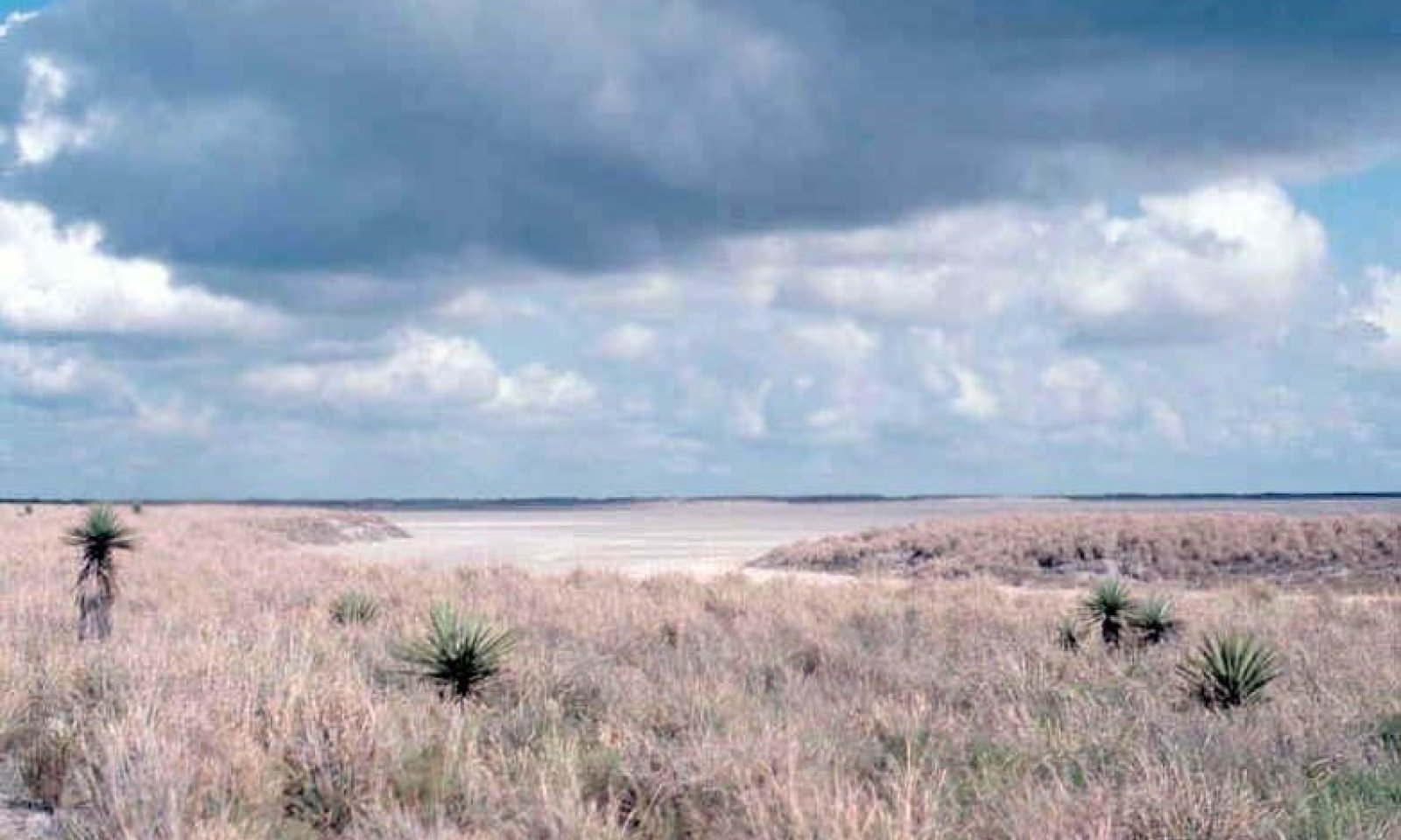
Coastal Ridges are found inland, west of the barrier islands. They are comprised of sandy clay loams and clay loams instead of pure sands. They are often referred to as clay dunes.
Associated sites
R150BY551TX Salty Prairie
These areas are on a higher landform.
R150BY708TX Sandy Flat
These areas are on a similar to slightly lower landform and have more sand throughout.
Similar sites
R150BY714TX Coastal Dune
These areas have more sand throughout.
Table 1. Dominant plant species
Tree Not specified
Shrub Not specified
Herbaceous (1) Sporobolus wrightii
(2) Trichloris crinitaPhysiographic features
These nearly level to sloping soils are on convex sloping coastal ridges. Slope ranges from 1 to 8 percent.
Table 2. Representative physiographic features
Landforms (1) Coastal plain > Dune
Runoff class Medium to very high Flooding frequency None to rare Ponding frequency None Elevation 3 – 49 ft Slope 1 – 8 % Water table depth 72 in Climatic features
The climate is predominately maritime, controlled by the warm and very moist air masses from the Gulf of Mexico. The climate along the upper coast of the barrier islands is subtropical subhumid and the climate on the lower coast of Padre Island is subtropical semiarid (due to high evaporation rates that exceed precipitation). Almost constant sea breezes moderate the summer heat along the coast. Winters are generally warm and are occasionally interrupted by incursions of cool air from the north. Spring is mild and damaging wind and rain may occur during spring and summer months. Tropical cyclones or hurricanes can occur with wind speeds of greater than 74 mph and have the potential to cause flooding from torrential rainstorms. Despite the threat of tropical storms, the storms are rare. Throughout the year, the prevailing winds are from the southeast to south-southeast.
The average annual precipitation is 45 to 57 inches in the northeastern half of this area, 26 inches at the extreme southern tip of the area, and 30 to 45 inches in the rest of the area. Precipitation is abundant in spring and fall in the southwestern part of the area and is evenly distributed throughout the year in the northeastern part. Rainfall typically occurs as moderate-intensity, tropical storms that produce large amounts of rain during the winter. The average annual temperature is 68 to 74 degrees F. The freeze-free period averages 340 days and ranges from 315 to 365 days.Table 3 Representative climatic features
Frost-free period (characteristic range) 370 days Freeze-free period (characteristic range) 370 days Precipitation total (characteristic range) 30-30 in Frost-free period (actual range) 370 days Freeze-free period (actual range) 370 days Precipitation total (actual range) 30-30 in Frost-free period (average) 370 days Freeze-free period (average) 370 days Precipitation total (average) 30 in Characteristic rangeActual rangeBarLineFigure 2. Monthly precipitation range
Characteristic rangeActual rangeBarLineFigure 3. Monthly minimum temperature range
Characteristic rangeActual rangeBarLineFigure 4. Monthly maximum temperature range
BarLineFigure 5. Monthly average minimum and maximum temperature
Figure 6. Annual precipitation pattern
Figure 7 Annual average temperature pattern
Climate stations used
-
(1) CORPUS CHRISTI NAS [USW00012926], Corpus Christi, TX
-
(2) PADRE IS NS [USC00416739], Padre Island Ntl Seashor, TX
-
(3) PORT MANSFIELD [USC00417184], Port Mansfield, TX
-
(4) PORT ISABEL [USC00417179], Port Isabel, TX
">Influencing water features
Areas closest to the coastline may be flooded by seawater from high tides or tropical storms for brief periods.
Wetland description
These areas are not hydric but some small areas may exist that are hydric. Onsite investigation needed to determine local conditions.
Soil features
The series consists of very deep, well drained, moderately slowly to slowly permeable soils that formed in loamy and calcareous loamy, eolian deposits. The soils correlated to this site include: Lalinda and Point Isabel.
Table 4. Representative soil features
Parent material (1) Eolian deposits – igneous, metamorphic and sedimentary rock
Surface texture (1) Sandy clay loam
(2) Clay loam
Family particle size (1) Fine
(2) Fine-loamy
Drainage class Well drained Permeability class Moderately slow to slow Soil depth 80 in Surface fragment cover <=3" Not specified Surface fragment cover >3" Not specified Available water capacity
(0-60in)4 – 6 in Calcium carbonate equivalent
(0-60in)8 – 18 % Electrical conductivity
(0-12in)2 – 8 mmhos/cm Sodium adsorption ratio
(0-12in)3 – 13 Soil reaction (1:1 water)
(0-60in)7.4 – 9 Ecological dynamics
The Texas coastline is composed of barrier islands, peninsulas, bays, estuaries, and natural or man-made passes. These mobile environments are constantly reshaped by the process of erosion and accretion. Hurricane activity can significantly change the environment drastically. The Padre Island region is subdivided into habitats based on landform and vegetation. The Coastal Ridge ecological site lies inland of the bay. The landforms vary from in size and are also known as clay dunes.
The plant communities are dynamic, and composition may vary dramatically with variations in annual rainfall, grazing, and fire. This landscape is typically a vegetated barrier flat unless impacted by recent hurricane activity. Because of southern proximity and nearness to the Gulf of Mexico, extreme climatic variations ranging from extended drought to hurricanes are possible. Bare ground may predominate during droughts or following hurricanes while a midgrass prairie may predominate under proper management and non-droughty periods.
The intensity of a hurricane plays a large role in the plant community. Due to the extensive creeping rhizomes and ability to tolerate high salinity levels, gulfdune paspalum can survive a moderately-intensive hurricane while other species cannot. Following a hurricane, the plant community will consist of gulfdune paspalum and various annual pioneer plants. Following a severe hurricane, vegetation will be virtually devoid. Length of recovery to reference conditions will depend severity and the ability to defer from grazing or other major natural disturbance.
Active sand dunes occur on this site. Overuse by livestock exacerbates dune formation. Continuous dunes sometimes cover several square miles. The dunes add to landscape diversity but can pose management problems because they migrate across the landscape and may cover fences, roads, equipment, and buildings. Cutting native hay near a sand dune and mulching the dune with the hay while lightly incorporating the hay into the soil is an effective method of stabilizing dunes.State and transition model
More interactive model formats are also available. View Interactive Models
Click on state and transition labels to scroll to the respective textEcosystem states
T1A - Loss of vegetative cover R2A - Natural regeneration over time State 1 submodel, plant communities
State 2 submodel, plant communities
State 1
Vegetated DuneDominant plant species
-
big sacaton (Sporobolus wrightii), grass
-
false Rhodes grass (Trichloris crinita), grass
Community 1.1
Vegetated Dune
The reference vegetation of this ecological site occurs as a grassland with scattered brush and pricklypear. The composition by weight is about 85 percent grasses, 5 percent forbs, and 10 percent woody plants. Approximate total annual yield ranges from 1,000 pounds per acre of air-dry vegetation in low production years to 5,000 pounds per acre of air-dry vegetation in above average production years.
Approximately 65 percent of the vegetation is made up of a combination of tall and midgrasses such as giant sacaton, false Rhodesgrass, Arizona cottontop, and plains bristlegrass and the remaining 20 percent are short grass species such as buffalograss, fall witchgrass, hooded windmillgrass, pink pappusgrass, and lovegrass tridens. Approximately 10 percent of species composition is composed of shrubs and cacti such as desert yaupon, spiny hackberry, condalia, twisted acacia, and pricklypear. The remaining 5 percent species composition is composed of forbs which include sensitive briar, dalea, orange zexmenia, and bush sunflower.
As retrogression occurs, grasses that dominate the site give way to condalia, spiny hackberry, cenizo, coyotillo, leatherstem, and pricklypear forming a dense chaparral type landscape. Some common invaders on this site include red grama, whorled dropseed, gummy lovegrass, and acacia species. If further overgrazing or hurricanes occur, the site will transition to State 2.Figure 8. Annual production by plant type (representative values) or group (midpoint values)
Table 5. Annual production by plant type
Plant type Low
(lb/acre)Representative value
(lb/acre)High
(lb/acre)Grass/Grasslike 850 2550 4250 Shrub/Vine 100 300 500 Forb 50 150 250 Total 1000 3000 5000 State 2
Active DunesCommunity 2.1
Hurricane Impacted and BlowoutsThis plant community forms because of continued overgrazing or a hurricane. Overgrazing removes all vegetation and allows the dune to become unstable. Hurricanes cause the vegetation to be burned by high salinity content carried by high winds laden with coastal water. Vegetation can also be buried under thick sediment deposits of sand. Some areas are scoured and devoid of vegetation and may temporarily suffer complete vegetative loss. This community can recover to reference conditions given enough time. Deferment is the main management practice for recovery. Vegetation typically reestablishes through propagules sent by remaining plants, therefore recovery will be dependent on remnant population densities.
Transition T1A
State 1 to 2Severe overgrazing or hurricane will cause State 1 to transition to State 2.
Restoration pathway R2A
State 2 to 1Time and prescribed grazing (deferment) are required to restore the community to reference conditions.
Additional community tables
Table 6. Community 1.1 plant community composition
Group Common name Symbol Scientific name Annual production () Foliar cover (%) Table 7. Community 2.1 plant community composition
Group Common name Symbol Scientific name Annual production () Foliar cover (%) Interpretations
Animal community
The animal communities of the Coastal Prairie communities are influenced by fresh and salt water inundations. Cattle and many species of wildlife make extensive use of the site. White-tailed deer may be found scattered across the prairie and are found in heavier concentrations where woody cover exists. Feral hogs are present and at times become abundant. Coyotes are abundant and fill the mammalian predator niche. Rodent populations rise during drier periods and fall during periods of inundation. Alligators are locally abundant and make frequent use of the marshes depending on salt concentrations in the marshes.
The region is a major flyway for waterfowl and migrating birds. Hundreds of thousands of ducks, geese, and sandhill cranes abound during winter. Whooping cranes are an important endangered species that occur in the area, especially near Aransas National Wildlife Refuge. Northern harriers are common predatory birds seen patrolling marshes. Curlews, plovers, sandpipers, and willets are shorebirds that make use of the tidal areas. Seagulls and terns are plentiful throughout the year trolling the shores as well. Further inland, rails, gallinules, and moorhens make use of the brackish marshes.Supporting information
Inventory data references
Information presented was derived from the Range Site Description, NRCS clipping data, literature, field observations, and personal contacts with range-trained personnel.
Other references
Archer, S. 1994. Woody plant encroachment into southwestern grasslands and savannas: rates, patterns and proximate causes. Ecological implications of livestock herbivory in the West, 13-68.
Archer, S. and F. E. Smeins. 1991. Ecosystem-level processes. Grazing Management: An Ecological Perspective. Edited by R.K. Heischmidt and J.W. Stuth. Timber Press, Portland, OR.
Bailey, V. 1905. North American Fauna No. 25: Biological Survey of Texas. United States Department of Agriculture Biological Survey. Government Printing Office, Washington D. C.
Beasom, S. L, G. Proudfoot, and J. Mays. 1994. Characteristics of a live oak-dominated area on the eastern South Texas Sand Plain. In the Caesar Kleberg Wildlife Research Institute Annual Report, 1-2.
Bestelmeyer, B. T., J. R. Brown, K. M. Havstad, R. Alexander, G. Chavez, and J. E. Herrick. 2003. Development and use of state-and-transition models for rangelands. Journal of Range Management, 56(2):114-126.
Briske, B. B, B. T. Bestelmeyer, T. K. Stringham, and P. L. Shaver. 2008. Recommendations for development of resilience-based State-and-Transition Models. Rangeland Ecology and Management, 61:359-367.
Brown, J. R. and S. Archer. 1999. Shrub invasion of grassland: recruitment is continuous and not regulated by herbaceous biomass or density. Ecology, 80(7):2385-2396.
Butzler, R. E. 2006. The Spatial and Temporal Patterns of Lycium carolinianum Walt. M. S. Thesis. Texas A&M, College Station, TX.
Chabreck, R. H. 1972. Vegetation, water and soil characteristics of the Louisiana coastal region. Louisiana State University Agriculture Experiment Station Bulletin, 664.
Davis, W. B. 1974. The Mammals of Texas. Texas Parks and Wildlife Department Bulletin, 41.
Drawe, D. L., A. D. Chamrad, and T. W. Box. 1978. Plant communities of the Welder Wildlife Refuge. The Welder Wildlife Refuge, Sinton, TX.
Drawe, D. L., K. R. Kattner, W. H. McFarland, and D. D. Neher. 1981. Vegetation and soil properties of five habitat types on north Padre Island. Texas Journal of Science, 33:145-157.
Everitt, J. H., D. L. Drawe, and R. I. Leonard. 2002. Trees, Shrubs, and Cacti of South Texas. Texas Tech University Press, Lubbock, TX.
Foster, J. H. 1917. Pre-settlement fire frequency regions of the United States: A first approximation. Tall Timbers Fire Ecology Conference Proceedings, 20.
Frost, C. C. 1995. Presettlement fire regimes in southeastern marshes, peatlands, and swamps. Tall Timbers Fire Ecology Conference Proceedings, 19:39-60.
Fulbright, T. E., D. D. Diamond, J. Rappole, and J. Norwine. 1990. The Coastal Sand Plain of Southern Texas. Rangelands, 12:337-340.
Fulbright, T. E., J. A. Ortega-Santos, A. Lozano-Cavazos, and L. E. Ramirez-Yanez. 2006. Establishing vegetation on migrating inland sand dunes in Texas. Rangeland Ecology and Management, 59:549-556.
Gosselink, J.D., C.L. Cordes, and J.W. Parsons. 1979. An. Ecological characterization study of the Chenier Plain Coastal Ecosystem of Louisiana and Texas. U.S. Fish and Wildlife Service, Office of Biological Services, Washington, D.C.
Gould, F. W. 1975. The Grasses of Texas. Texas A&M University Press, College Station, TX.
Gould, F. W. and T. W. Box. 1965. Grasses of the Texas Coastal Bend. Texas A&M University Press, College Station, TX.
Grace, J. B., L. K. Allain, H. Q. Baldwin, A. G. Billock, W. R. Eddleman, A. M. Given, C. W. Jeske, and R. Moss. 2005. Effects of prescribed fire in the coastal prairies of Texas. USGS Open File Report, 2005-1287.
Hamilton, W. and D. Ueckert. 2005. Rangeland woody plant control: Past, present, and future. Brush management: Past, present, and future, 3-16.
Harcombe, P. A. and J. E. Neaville. 1997. Vegetation types of Chambers County, Texas. The Texas Journal of Science, 29:209-234.
Hatch, S. L., J. L. Schuster, and D. L. Drawe. 1999. Grasses of the Texas Gulf Prairies and Marshes. Texas A&M University Press, College Station, TX.
Johnson, M. C. 1963. Past and present grasslands of southern Texas and northeastern Mexico. Ecology 44(3):456-466.
Lehman, V. W. 1965. Fire in the range of Attwater’s prairie chicken. Tall Timbers Fire Ecology Conference Proceedings, 4:127-143.
Mann, C. 2004. 1491: New Revelations of the Americas before Columbus. Vintage Books, New York City, NY.
Mapston, M. E. 2007. Feral Hogs in Texas. Texas Agrilife Extension Bulletin, B-6149
McAtee, J. W., C. J. Scifres, D. L. and Drawe. 1979. Digestible energy and protein content of gulf cordgrass following burning or shredding. Journal of Range Management, 376-378.
McGowen, J. H., L. F. Brown, T. J. Evans, W. L. Fisher, and C. G. Groat. 1976. Environmental geologic atlas of the Texas Coastal Zone-Bay City-Freeport area. The University of Texas at Austin, Bureau of Economic Geology, Austin, TX.
Miller, D. L., F. E Smeins, and J. W. Webb. 1998. Response of a Texas Distichlis spicata coastal marsh following Lesser Snow Goose herbivory. Aquatic Botany, 61:301-307.
Miller, D. L., F. E. Smeins, and J. W. Webb. 1996. Mid-Texas coastal marsh change (1939-1991) as influenced by Lesser Snow Goose herbivory. Journal of Coastal Research, 12:462-476.
Miller, D. L., F. E. Smeins, J. W. Webb, and M. T. Longnecker. 1997. Regeneration of Scirpus americanus in a Texas coastal marsh following Lesser Snow Goose herbivory. Wetlands, 17:31-42.
Oefinger, R. D. and C. J. Scifres. 1977. Gulf cordgrass production, utilization, and nutritional value following burning. Texas Agricultural Experiment Station Bulletin, B-1176.
Palmer, G. R., T. E. Fulbright, and G. McBryde. 1995. Inland sand dune reclamation on the Coastal Sand Plain of Southern Texas. Caesar Kleberg Wildlife Research Institute Annual Report, 1994-1995.
Prichard, D. 1998. Riparian area management: A user guide to assessing proper functioning condition and the supporting science for lotic areas. Bureau of Land Management, Denver, CO.
Rappole, J. H. and G. W. Blacklock. 1985. Birds of the Texas Coastal Bend: Abundance and distribution. Texas A&M University Press, College Station, TX.
Scifres, C. J. and W. T. Hamilton. 1993. Prescribed burning for brushland management: The South Texas example. Texas A&M Press, College Station, TX.
Scifres, C. J., J. W. McAtee, and D. L. Drawe 1980. Botanical, edaphic, and water relationships of gulf cordgrass (Spartina spartinae [Trin.] Hitchc.) and associated communities. The Southwestern Naturalist, 25(3):397-409.
Shiflet, T. N. 1963. Major ecological factors controlling plant communities in Louisiana marshes. Journal of Range Management, 16:231-235.
Singleton, J. R. 1951. Production and utilization of waterfowl food plants on the east Texas gulf coast. Journal of Wildlife Management, 15:46-56.
Smeins, F. E., D. D. Diamond, and W. Hanselka. 1991. Coastal prairie, 269-290. Ecosystems of the World: Natural Grasslands. Edited by R. T. Coupland. Elsevier Press, Amsterdam, Netherlands.
Smeins, F. E., S. Fuhlendorf, and C. Taylor, Jr. 1997. Environmental and land use changes: A long term perspective. Juniper Symposium, 1-21.
Snyder, R. A. and C. L. Boss. 2002. Recovery and stability in barrier island plant communities. Journal of Coastal Research, 18:530-536.
Stoddart, L. A., A. D. Smith, and T. W. Box. 1975. Range management. McGraw-Hill Book Co., New York, NY.
Stringham, T. K., W. C. Krueger, and P. L. Shaver. 2001. State and transition modeling: An ecological process approach. Journal of Range Management, 56(2):106-113.
Thornthwaite, C. W. 1948. An approach towards a rational classification of climate. Geographical Review, 38: 55-94.
Thurow, T. L. 1991. Hydrology and erosion. Grazing Management: An Ecological Perspective. Edited by R.K. Heitschmidt and J.W. Stuth. Timber Press, Portland, OR.
Urbatsch, L. 2000. Chinese tallow tree Triadica sebifera (L.) Small. USDA-NRCS, National Plant Center, Baton Rouge, LA.
Van’t Hul, J. T., R. S. Lutz, and N. E. Mathews. 1997. Impact of prescribed burning on vegetation and bird abundance on Matagorda Island, Texas. Journal of Range Management, 50:346-360.
Vines, R. A. 1977. Trees of Eastern Texas. University of Texas Press, Austin, TX.
Vines, R. A. 1984. Trees of Central Texas. University of Texas Press, Austin, TX.
Wade, D. D., B. L. Brock, P. H. Brose, J. B. Grace, G. A. Hoch, and W. A. Patterson III. 2000. Fire in Eastern ecosystems. Wildland fire in ecosystems: effects of fire on flora. Edited by. J. K. Brown and J. Kaplers. United States Forest Service, Rocky Mountain Research Station, Ogden, UT.
Warren, W. S. 1998. The La Salle Expedition to Texas: The journal of Henry Joutel, 1684-1687. Edited by W. C. Foster. Texas State Historical Association, Austin, TX.
Weaver, J. E. and F. E. Clements. 1938. Plant ecology. McGraw-Hill, New York, NY.
Williams, A. M., R. A. Feagin, W.K. Smith, and N. L. Jackson. 2009. Ecosystem impacts of Hurricane Ike on Galveston Island and Bolivar Peninsula: Perspectives of the coastal barrier island network (CBIN). Shore and Beach, 7(2):1-5.
Williams, L. R. and G. N Cameron. 1985. Effects of removal of pocket gophers on a Texas coastal prairie. The American Midland Naturalist Journal, 115:216-224.
Wright, H.A. and A.W. Bailey. 1982. Fire Ecology: United States and Southern Canada. John Wiley & Sons, Inc., Hoboken, NJ.Contributors
Tyson Hart, Ecologist, NRCS, Nacogdoches, TX
Approval
Bryan Christensen, 9/22/2023
Acknowledgments
Amanda Brown, RMS, NRCS, Nacogdoches, TX Site Development and Testing Plan: Future work, as described in a Project Plan, to validate the information in this Provisional Ecological Site Description is needed. This will include field activities to collect low, medium and high-intensity sampling, soil correlations, and analysis of that data. Annual field reviews should be done by soil scientists and vegetation specialists. A final field review, peer review, quality control, and quality assurance reviews of the ESD will be needed to produce the final document. Annual reviews of the Project Plan are to be conducted by the Ecological Site Technical Team.
Rangeland health reference sheet
Interpreting Indicators of Rangeland Health is a qualitative assessment protocol used to determine ecosystem condition based on benchmark characteristics described in the Reference Sheet. A suite of 17 (or more) indicators are typically considered in an assessment. The ecological site(s) representative of an assessment location must be known prior to applying the protocol and must be verified based on soils and climate. Current plant community cannot be used to identify the ecological site.
Author(s)/participant(s) Contact for lead author Date 08/19/2026 Approved by Approval date Composition (Indicators 10 and 12) based on Annual Production Indicators
-
Number and extent of rills:
-
Presence of water flow patterns:
-
Number and height of erosional pedestals or terracettes:
-
Bare ground from Ecological Site Description or other studies (rock, litter, lichen, moss, plant canopy are not bare ground):
-
Number of gullies and erosion associated with gullies:
-
Extent of wind scoured, blowouts and/or depositional areas:
-
Amount of litter movement (describe size and distance expected to travel):
-
Soil surface (top few mm) resistance to erosion (stability values are averages - most sites will show a range of values):
-
Soil surface structure and SOM content (include type of structure and A-horizon color and thickness):
-
Effect of community phase composition (relative proportion of different functional groups) and spatial distribution on infiltration and runoff:
-
Presence and thickness of compaction layer (usually none; describe soil profile features which may be mistaken for compaction on this site):
-
Functional/Structural Groups (list in order of descending dominance by above-ground annual-production or live foliar cover using symbols: >>, >, = to indicate much greater than, greater than, and equal to):
Dominant:
Sub-dominant:
Other:
Additional:
-
Amount of plant mortality and decadence (include which functional groups are expected to show mortality or decadence):
-
Average percent litter cover (%) and depth ( in):
-
Expected annual annual-production (this is TOTAL above-ground annual-production, not just forage annual-production):
-
Potential invasive (including noxious) species (native and non-native). List species which BOTH characterize degraded states and have the potential to become a dominant or co-dominant species on the ecological site if their future establishment and growth is not actively controlled by management interventions. Species that become dominant for only one to several years (e.g., short-term response to drought or wildfire) are not invasive plants. Note that unlike other indicators, we are describing what is NOT expected in the reference state for the ecological site:
-
Perennial plant reproductive capability:
Print Options
Sections
Font
AAAAOther
PrintThe Ecosystem Dynamics Interpretive Tool is an information system framework developed by the USDA-ARS Jornada Experimental Range, USDA Natural Resources Conservation Service, and New Mexico State University.
Accessibility statement


