
Natural Resources
Conservation Service
Ecological site F131DY005AR
Loamy Prairie Terrace
Last updated: 9/22/2023
Accessed: 10/05/2026
-
Search


Major Land Resource Area or ecological site by name and/or ID.
PreviousSectionsNextGeneral information
Provisional. A provisional ecological site description has undergone quality control and quality assurance review. It contains a working state and transition model and enough information to identify the ecological site.
MLRA notes
Major Land Resource Area (MLRA): 131D–Southern Mississippi River Terraces
Major Land Resource Area (MLRA) 131D, Southern Mississippi River Terraces, is located in Arkansas (88 percent) and Louisiana (12 percent). It is in two separate areas that together make up about 2,945 square miles. The towns of Lonoke and Stuttgart, Arkansas, are in the northeastern part of the MLRA, which is called the Grand Prairie. Bastrop, Louisiana, is in the southwestern part of the MLRA.
Classification relationships
USDA-Natural Resources Conservation Service, 2006.
-Major Land Resource Area (MLRA) 131DEcological site concept
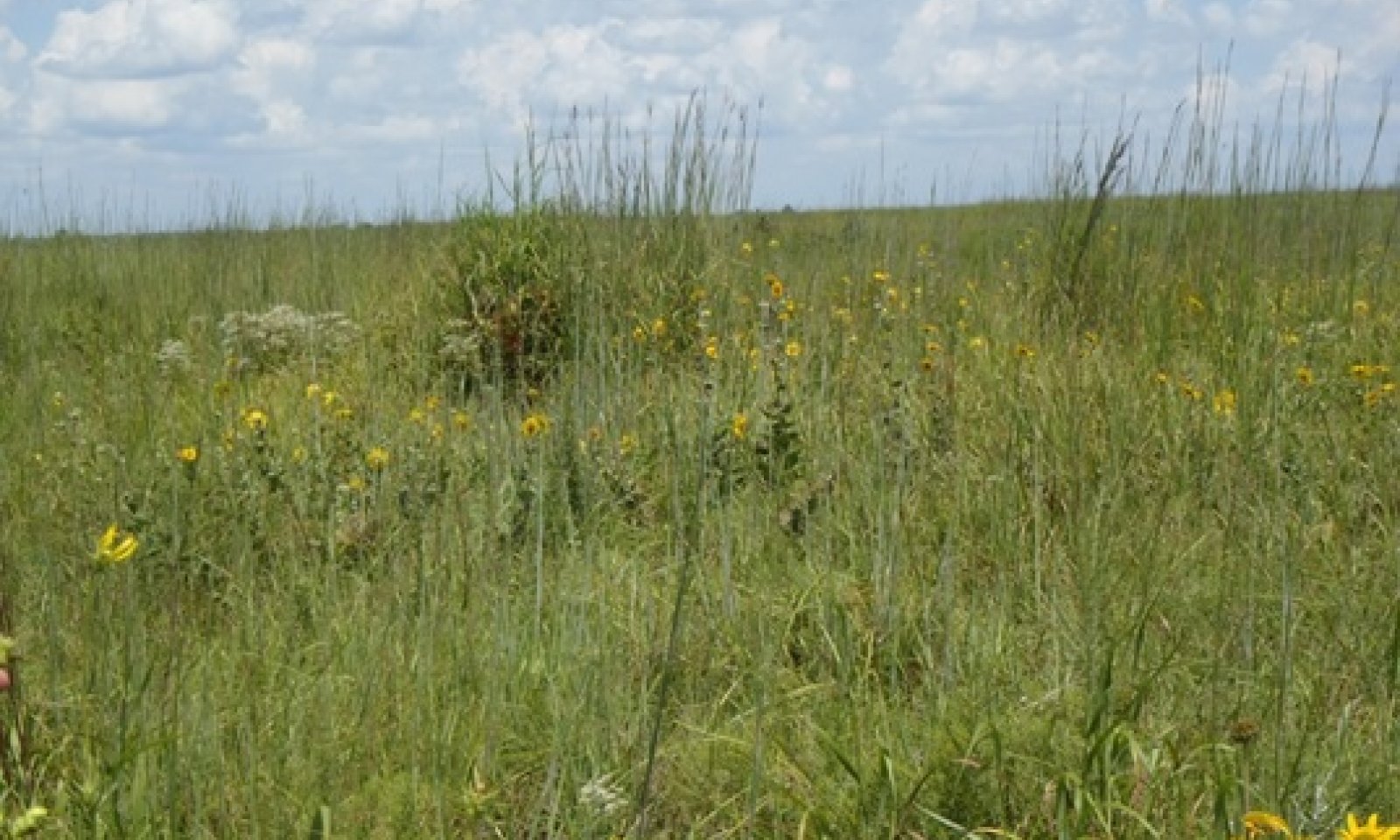
The Loamy Prairie Terrace is a tallgrass prairie, dominated by switchgrass (Panicum virgatum) and big bluestem (Andropogon gerardii). The sites are productive and the site is maintained by frequent fires every one to three years.
Associated sites
F131DY003AR Sodic Terrace
Sites are on the same landform, but have a sodic horizon.
F131DY004AR Loess Terrace
Sites are on the same landform, but have a fragipan in the subsurface.
F131DY006AR Clayey Terrace
Sites are on a similar landform, but have clayey textures throughout the profile.
Similar sites
F131BY001AR Loamy Terrace
Sites are similar, but in a different MLRA.
Table 1. Dominant plant species
Tree Not specified
Shrub Not specified
Herbaceous (1) Panicum virgatum
(2) Andropogon gerardiiPhysiographic features
These soils are on broad, level to nearly level prairie terraces. Slope is dominantly less than 8 percent, but ranges to 25 percent. Sites can have a high water table, especially during winter and early spring.
Table 2. Representative physiographic features
Geomorphic position, terraces (1) Tread
(2) Riser
Landforms (1) Coastal plain > Terrace
Runoff class Negligible to very high Flooding frequency None Ponding frequency None Elevation 50 – 250 ft Slope 0 – 25 % Water table depth 12 – 30 in Aspect Aspect is not a significant factor Climatic features
The average annual precipitation is 53 inches, which increases from north to south. Most of the rainfall occurs as frontal storms in spring and early summer. Some high-intensity, convective thunderstorms occur in summer. The average seasonal snowfall is five inches. Temperatures range from highs in the low 90's during the summer to lows in the low 30's during the winter. The frost-free period averages 221 days, while the freeze-free period averages 246 days.
Table 3 Representative climatic features
Frost-free period (average) 220 days Freeze-free period (average) 250 days Precipitation total (average) 50 in BarLineFigure 1. Monthly precipitation range
BarLineFigure 2. Monthly average minimum and maximum temperature
Figure 3. Annual precipitation pattern
Figure 4 Annual average temperature pattern
Climate stations used
-
(1) ARKANSAS POST [USC00030240], Gillett, AR
-
(2) DES ARC [USC00031968], Des Arc, AR
-
(3) CROSSETT 2 SSE [USC00031730], Crossett, AR
-
(4) SAINT CHARLES [USC00036376], Clarendon, AR
-
(5) STUTTGART 9 ESE [USC00036920], Stuttgart, AR
">Influencing water features
The sites exhibit a high water table, especially during the winter and early spring. Also, some of the soils correlated to the site are classified as hydric, but onsite delineations are required to determine if the site is a wetland as defined by the United States Army Corps of Engineers.
Wetland description
Some of the soils correlated to the site are classified as hydric, but onsite delineations are required to determine if the site is a wetland as defined by the United States Army Corps of Engineers.
Soil features
The soils consist of very deep, moderately well to poorly drained, moderately slowly permeable to impermeable soils that formed in alluvium and deposits of loess. The taxonomic classification varies, but almost all are classified as alfisols. Soils correlated to this site include: Calhoun, Dewitt, Ethel, Idee, Immanuel, Muskogee, Oaklimeter, and Stuttgart.
Table 4. Representative soil features
Parent material (1) Loess – igneous, metamorphic and sedimentary rock
(2) Alluvium – igneous, metamorphic and sedimentary rock
(3) Marine deposits – igneous, metamorphic and sedimentary rock
Surface texture (1) Silt loam
Family particle size (1) Loamy
(2) Clayey
Drainage class Poorly drained to moderately well drained Permeability class Moderately slow to slow Soil depth 80 in Surface fragment cover <=3" Not specified Surface fragment cover >3" Not specified Available water capacity
(0-40in)7 – 8 in Calcium carbonate equivalent
(0-40in)Not specified Electrical conductivity
(0-40in)0 – 1 mmhos/cm Sodium adsorption ratio
(0-40in)0 – 10 Soil reaction (1:1 water)
(0-40in)4.5 – 8.4 Subsurface fragment volume <=3"
(Depth not specified)Not specified Subsurface fragment volume >3"
(Depth not specified)Not specified Ecological dynamics
The information in this ecological site description (ESD), including the state-and-transition model (STM), was developed using archeological and historical data, professional experience, and scientific studies. The information is representative of a complex set of plant communities. Not all scenarios or plants are included. Key indicator plants, animals, and ecological processes are described to inform land management decisions.
Introduction - The Southern Mississippi River Terrace (MLRA 131D) region is on smooth terraces and floodplains along the Mississippi River and its major tributaries south of its confluence with the Ohio River. The geologic material in the region consists of very thick deposits of sandy to clayey alluvium of Pleistocene to Holocene age. This material was deposited by the rivers with local relief is typically less than 15 feet and elevation ranging from 50 to 250 feet.
Geology - Bedrock in this area consists of Tertiary and Cretaceous sands formed as beach deposits during the retreat of the Cretaceous ocean from the midsection of the United States. Alluvial deposits from flooding and lateral migration of the rivers crossing this area typically lie above the bedrock. These sediments form Pleistocene-age alluvial terraces. Silty alluvium underlies most of the area. Clayey sediments are in old channel scars. The Pleistocene terraces are part of the Prairie Terrace complex. A minor portion of the area is in the Deweyville and Montgomery terrace formation. These terraces have a base of red alluvium capped by one to several feet of brownish alluvium.
Biological Resources - This area as a whole, supports hardwoods and pines. The Grand Prairie originally supported tall prairie grasses interlaced with hardwood timber. Cherrybark oak (Quercus pagoda) and Shumard oak (Quercus shumardii) are widely distributed. Tuliptree (Liriodendron tulipifera), white ash (Fraxinus americana), eastern cottonwood (Populus deltoides), and black walnut (Juglans nigra) are important species on the flood plains. Loblolly pine (Pinus taeda) and shortleaf pine (Pinus echinata) are on a wide variety of sites, mainly the eroded soils on uplands and ridges. Other hardwood species that commonly grow in this area are white oak (Quercus alba), basswood (Tillia sp.), sweetgum (Liquidambar styraciflua), water oak (Quercus nigra), American elm (Ulmus americana), blackgum (Nyssa sylvatica), sycamore (Plantanus occidentalis), sassafras (Sassafras albidum), southern red oak (Quercus falcata), chinkapin oak (Quercus muehlenbergii), American beech (Fagus grandifolia), and hickory (Carya sp.).
Land Use - Land use varies throughout the MLRA consisting of 42 percent cropland, 4 percent grassland, 47 percent forest, 3 percent urban development, 3 percent water, and 1 percent other. Scattered tracts of forests and farms make up nearly all of this area. Rice, soybeans, and wheat are the main crops. In most areas furrow or flood irrigation is used throughout the growing season. Hardwood timber is harvested on some forested wetlands, and most forested areas are managed for wildlife. Bait fish are produced commercially in ponds that are contained by levees. The area is in a major migratory flight path and hunting waterfowl is a popular recreation activity.
Conservation - The major soil resource concerns are management of soil moisture, erosion control, and maintenance of the content of organic matter and productivity of the soils. Depletion of ground water through excessive pumping is a major concern in the Grand Prairie area. Conservation practices on cropland generally include nutrient management, crop residue management, and alternative tillage systems, especially no-till systems that reduce the need for tillage. In many areas land leveling or shaping optimizes the control of surface water. Other major cropland management practices are control of competing vegetation and insects through aerial or ground spraying of herbicides and insecticides and fertility management programs that make use of chemical fertilizers.State and transition model
Custom diagramStandard diagram
Figure 5. STM
More interactive model formats are also available. View Interactive Models
More interactive model formats are also available. View Interactive Models
Click on state and transition labels to scroll to the respective textEcosystem states
State 1 submodel, plant communities
State 2 submodel, plant communities
State 3 submodel, plant communities
State 4 submodel, plant communities
State 1
PrairieThis ecological site is a tallgrass prairie. Historic accounts and a few remnant locations show evidence of the prairie. The site's productive, yet sometimes droughty, soils provide a good medium for frequent fires. Dormant season and late-growing season fires are estimated to have occurred every one to three years.
Community 1.1
Tallgrass Prairie
The vegetation adapted to the large, flat expanses was a diverse tallgrass prairie. Switchgrass and big bluestem are the dominant grasses. Other species include: little bluestem (Schizachyrium scoparium), Indiangrass (Sorghastrum nutans), and eastern gamagrass (Tripsacum dactyloides) in wetter areas. Forbs include: compass plant (Silphium laciniatum), prairie blazing star (Liatris spicata), black-eyed susan (Rudbeckia hirta), and partridge pea (Chamaecrista fasciculata).
State 2
ForestProlonged absence of fire in the Prairie State will transition into the Forest State. Without natural fire intervals of one to three years, woody species become established. Within a few years they can grow to a height where fire is ineffective at controlling their growth. They eventually grow to densities where light is restricted to the grasses and forbs, and only shade tolerant species can thrive.
Community 2.1
Slash ForestGreen ash (Fraxinus pennsylvanica) and hawthorns (Crataegus sp.) are the dominant species in the Slash Forest. Other trees include: sugarberry (Celtis laevigata) and elms (Ulmus sp.). Slash Forest communities lack the fire regime found in the Tallgrass Prairie communities due to reduction in fine fuels.
State 3
PlantationThe Plantation State is a result of conversion activities. The landowner has maximized silviculture production by planting a monoculture of tree species.
Community 3.1
Pine/Hardwood PlantationIn the immediate years following the initial plantation tree planting, the understory community will resemble State 1. During this early growth period, the landowner will typically remove unwanted tree species and herbaceous plants to reduce competition with the planted trees. As the overstory canopy closes, less understory management is required due to sunlight restrictions to the ground layer.
State 4
Pasture and CroplandThe Pasture and Cropland State is a result of conversion activities. The landowner has maximized agriculture production by planting a monoculture of introduced grass species or agricultural row crops.
Community 4.1
Planted Pasture and Row CropTypical perennial warm-season grasses include Bermudagrass, bahiagrass, dallisgrass, and Johnsongrass. Spring and fall forages may include legumes such as clover. The grasses are grown for livestock production through direct grazing or baling hay for later use. Agricultural row crops are grown for food and fiber production. Typical crops include cotton, soybeans, milo, corn, rice, and sugarcane. Many farmers use herbicides to reduce unwanted plant competition which yields a plant community unrepresentative of State 1 or subsequent vegetative states.
Transition T1A
State 1 to 2The transition from State 1 to State 2 is a result of time and long periods of no fire. Without fire to suppress seedlings, biomass and diversity is lost from the grass and forb layers.
Transition T1B
State 1 to 3The transition is due to the land manager maximizing silviculture potential. If present, merchantable timber is harvested by clearcut, then the site is prepared and planted to a monoculture of trees.
Transition T1C
State 1 to 4The transition is due to the land manager maximizing agricultural production. If present, merchantable timber is harvested by clearcut, then the site is prepared and planted to either a tame grass or row crop.
Restoration pathway R2A
State 2 to 1Restoration of this community to the reference state begins with a timber harvest. Removing trees opens up the canopy, allowing sunlight penetration to the ground. If the land has been forested for many decades, native seeds may be required if a seedbank does not exist. After a successful stand of grass has returned, natural burn intervals are required to keep woody species controlled.
Transition T2A
State 2 to 3The transition is due to the land manager maximizing silviculture potential. If present, merchantable timber is harvested by clearcut, then the site is prepared and planted to a monoculture of trees.
Transition T2B
State 2 to 4The transition is due to the land manager maximizing agricultural production. If present, merchantable timber is harvested by clearcut, then the site is prepared and planted to either a tame grass or row crop.
Restoration pathway R3A
State 3 to 1Restoration of this community to the reference state begins with a timber harvest. Removing trees opens up the canopy, allowing sunlight penetration to the ground. If the land has been forested for many decades, native seeds may be required if a seedbank does not exist. After a successful stand of grass has returned, natural burn intervals are required to keep woody species controlled.
Transition T3A
State 3 to 4The transition is due to the land manager maximizing agricultural production. If present, merchantable timber is harvested by clearcut, then the site is prepared and planted to either a tame grass or row crop.
Restoration pathway R4A
State 4 to 1Restoration of this community to the reference state begins by reseeding native seeds. After a successful stand of grass has returned, natural burn intervals are required to keep woody species controlled.
Transition T4A
State 4 to 3The transition is due to the land manager maximizing silviculture potential. If present, merchantable timber is harvested by clearcut, then the site is prepared and planted to a monoculture of trees.
Additional community tables
Table 5. Community 1.1 plant community composition
Group Common name Symbol Scientific name Annual production () Foliar cover (%) Table 6. Community 2.1 plant community composition
Group Common name Symbol Scientific name Annual production () Foliar cover (%) Table 7. Community 3.1 plant community composition
Group Common name Symbol Scientific name Annual production () Foliar cover (%) Table 8. Community 4.1 plant community composition
Group Common name Symbol Scientific name Annual production () Foliar cover (%) Interpretations
Supporting information
Inventory data references
This site description was developed as part of the provisional ecological site initiative using historic soil survey manuscripts, available range site descriptions, and low intensity field sampling.
Other references
Allen, J. A., B. D. Keeland, J. A. Stanturf, and A. F. Kennedy Jr. 2001. A guide to bottomland hardwood restoration. Technical report, USGS/BRD/ITR-2000-0011.
Louisiana Natural Heritage Program. 2009. The Natural Communities of Louisiana. Baton Rouge, LA, U.S.A. Data current as of August 2009.
NatureServe. 2013. International Ecological Classification Standard: Terrestrial Ecological Classifications. NatureServe Central Databases. Arlington, VA, U.S.A. Data current as of 12 July 2013.
Randall, J. M., and J. Marinelli. 1996. Invasive plants: weeds of the global garden. Volume 149. Brooklyn Botanic Garden, Brooklyn, NY.
Soil Survey Staff, Natural Resources Conservation Service, United States Department of Agriculture. Soil Survey Geographic (SSURGO) Database.
Stanturf, J. A., S. H. Schoenholtz, C. J. Schweitzer, and J. P. Shepard. 2001. Achieving restoration success: Myths in bottomland hardwood forests. Restoration Ecology, 9:189-200.
Stringham, T. K., W. C. Krueger, and P. L. Shaver. 2003. State and transition modeling: An ecological process approach. Journal of Range Management 56:106-113.
U.S. Army Corps of Engineers. 2010. Regional supplement to the Corps of Engineers Wetland Delineation Manual: Atlantic and Gulf Coastal Plain Region (Version 2.0). U.S. Army Corps of Engineers, Engineer Research and Development Center, Environmental Laboratory ERDC/EL TR-10-20.
USDA-NRCS Ag Handbook 296 (2006).Contributors
Tyson Hart
Marc BordelonApproval
Bryan Christensen, 9/22/2023
Rangeland health reference sheet
Interpreting Indicators of Rangeland Health is a qualitative assessment protocol used to determine ecosystem condition based on benchmark characteristics described in the Reference Sheet. A suite of 17 (or more) indicators are typically considered in an assessment. The ecological site(s) representative of an assessment location must be known prior to applying the protocol and must be verified based on soils and climate. Current plant community cannot be used to identify the ecological site.
Author(s)/participant(s) Contact for lead author Date 11/23/2021 Approved by Approval date Composition (Indicators 10 and 12) based on Annual Production Indicators
-
Number and extent of rills:
-
Presence of water flow patterns:
-
Number and height of erosional pedestals or terracettes:
-
Bare ground from Ecological Site Description or other studies (rock, litter, lichen, moss, plant canopy are not bare ground):
-
Number of gullies and erosion associated with gullies:
-
Extent of wind scoured, blowouts and/or depositional areas:
-
Amount of litter movement (describe size and distance expected to travel):
-
Soil surface (top few mm) resistance to erosion (stability values are averages - most sites will show a range of values):
-
Soil surface structure and SOM content (include type of structure and A-horizon color and thickness):
-
Effect of community phase composition (relative proportion of different functional groups) and spatial distribution on infiltration and runoff:
-
Presence and thickness of compaction layer (usually none; describe soil profile features which may be mistaken for compaction on this site):
-
Functional/Structural Groups (list in order of descending dominance by above-ground annual-production or live foliar cover using symbols: >>, >, = to indicate much greater than, greater than, and equal to):
Dominant:
Sub-dominant:
Other:
Additional:
-
Amount of plant mortality and decadence (include which functional groups are expected to show mortality or decadence):
-
Average percent litter cover (%) and depth ( in):
-
Expected annual annual-production (this is TOTAL above-ground annual-production, not just forage annual-production):
-
Potential invasive (including noxious) species (native and non-native). List species which BOTH characterize degraded states and have the potential to become a dominant or co-dominant species on the ecological site if their future establishment and growth is not actively controlled by management interventions. Species that become dominant for only one to several years (e.g., short-term response to drought or wildfire) are not invasive plants. Note that unlike other indicators, we are describing what is NOT expected in the reference state for the ecological site:
-
Perennial plant reproductive capability:
Print Options
Sections
Font
AAAAOther
PrintThe Ecosystem Dynamics Interpretive Tool is an information system framework developed by the USDA-ARS Jornada Experimental Range, USDA Natural Resources Conservation Service, and New Mexico State University.
Accessibility statement


