
Natural Resources
Conservation Service
Ecological site R116AY014MO
Dolomite Protected Cliff
Last updated: 9/24/2020
Accessed: 09/04/2026
-
Search


Major Land Resource Area or ecological site by name and/or ID.
PreviousSectionsNextGeneral information
Provisional. A provisional ecological site description has undergone quality control and quality assurance review. It contains a working state and transition model and enough information to identify the ecological site.
Click to explore map
Figure 1. Mapped extent
Areas shown in blue indicate the maximum mapped extent of this ecological site. Other ecological sites likely occur within the highlighted areas. It is also possible for this ecological site to occur outside of highlighted areas if detailed soil survey has not been completed or recently updated.
MLRA notes
Major Land Resource Area (MLRA): 116A–Ozark Highland
The Ozark Highland constitutes the Salem Plateau of the Ozark Uplift. Elevation ranges from about 300 feet on the southeast edge of the Ozark escarpment, to about 1,600 feet in the west, adjacent to the Burlington Escarpment of the Springfield Plateau. The underlying bedrock is mainly horizontally bedded Ordovician-aged dolomites and sandstones that dip gently away from the uplift apex in southeast Missouri. Cambrian dolomites are exposed on deeply dissected hillslopes. In some places, Pennsylvanian and Mississipian sediments overlie the plateau. Relief varies, from the gently rolling central plateau areas to deeply dissected hillslopes associated with drainageways such as the Buffalo, Current, Eleven Point and White Rivers.
Classification relationships
Terrestrial Natural Community Type in Missouri (Nelson, 2010):
The reference state for this ecological site is most similar to a Moist Limestone/Dolomite Cliff.
National Vegetation Classification System Vegetation Association (NatureServe, 2010):
The reference state for this ecological site is most similar to Limestone - Dolostone Midwest Moist Cliff Sparse Vegetation. (CEGL002292).
Geographic relationship to the Missouri Ecological Classification System (Nigh & Schroeder, 2002):
This ecological site occurs across the Ozark Highlands Section.Ecological site concept
NOTE: This is a “provisional” Ecological Site Description (ESD) that is under development. It contains basic ecological information that can be used for conservation planning, application and land management. After additional information is collected, analyzed and reviewed, this ESD will be refined and published as “Approved”.
Dolomite Protected Cliffs occur along deeply dissected river valleys throughout the Ozark Highland. They occupy northerly and easterly aspects, and are mapped in complex with the Dolomite Exposed Cliff ecological site. Soils are very shallow to dolomite. The reference plant community consists of scattered small trees, shrubs, grasses, forbs, and ferns, occupying cracks and ledges in the cliff face.Associated sites
F116AY016MO Chert Dolomite Protected Backslope Forest
Chert Dolomite Protected Backslope Forests are adjacent.
F116AY044MO Chert Dolomite Upland Woodland
Chert Dolomite Upland Woodlands are adjacent and upslope.
R116AY020MO Shallow Dolomite Upland Glade/Woodland
Shallow Dolomite Upland Glade/Woodlands are adjacent.
Similar sites
R116AY017MO Dolomite Exposed Cliff
Dolomite Exposed Cliffs are mapped in complex with the Dolomite Protected Cliff ecological sites.
Table 1. Dominant plant species
Tree (1) Acer saccharum
(2) Fraxinus quadrangulataShrub (1) Hydrangea arborescens
(2) Staphylea trifoliaHerbaceous (1) Aquilegia canadensis
(2) Solidago rugosaPhysiographic features
This site is on cliffs and steep backslopes of over 70 percent. It is on protected aspects (north, northeast, and east), which receive significantly less solar radiation than the exposed aspects. The site generates runoff to adjacent, downslope ecological sites, and in places receives runoff from upslope summit and shoulder sites. This site does not flood.
The following figure shows a typical landscape position of this ecological site, and landscape relationships with other ecological sites in the uplands. The site is within the area labeled “4”, on cliffs with northerly and easterly aspects. They are typically associated with Shallow Dolomite Glade/Woodland ecological sites, included within the area labeled “4”. Chert and Loamy Dolomite Upland Woodland ecological sites often directly upslope and are included within the area labeled “2 and 3”.
Figure 2. Landscape relationships for this ecological site.
Table 2. Representative physiographic features
Landforms (1) Cliff
Flooding frequency None Slope 15 – 100 % Water table depth 60 in Aspect NW, N, NE, E Climatic features
The Ozark Highland has a continental type of climate marked by strong seasonality. In winter, dry-cold air masses, unchallenged by any topographic barriers, periodically swing south from the northern plains and Canada. If they invade reasonably humid air, snowfall and rainfall result. In summer, moist, warm air masses, equally unchallenged by topographic barriers, swing north from the Gulf of Mexico and can produce abundant amounts of rain, either by fronts or by convectional processes. In some summers, high pressure stagnates over the region, creating extended droughty periods. Spring and fall are transitional seasons when abrupt changes in temperature and precipitation may occur due to successive, fast-moving fronts separating contrasting air masses.
The Ozark Highland experiences regional differences in climates, but these differences do not have obvious geographic boundaries. Regional climates grade inconspicuously into each other. The basic gradient for most climatic characteristics is along a line crossing the MLRA from northwest to southeast.
The average annual precipitation in almost all of this area is 38 to 45 inches. Snow falls nearly every winter, but the snow cover lasts for only a few days. The average annual temperature is about 53 to 60 degrees F. The lower temperatures occur at the higher elevations in the western part of the MLRA. Mean January minimum temperature follows a stronger north-to-south gradient. However, mean July maximum temperature shows hardly any geographic variation in the MLRA. Mean July maximum temperatures have a range of only two or three degrees across the area.
Mean annual precipitation varies along a northwest to southeast gradient. Seasonal climatic variations are more complex. Seasonality in precipitation is very pronounced due to strong continental influences. June precipitation, for example, averages three to four times greater than January precipitation. Most of the rainfall occurs as high-intensity, convective thunderstorms in summer.
During years when precipitation comes in a fairly normal manner, moisture is stored in the top layers of the soil during the winter and early spring, when evaporation and transpiration are low. During the summer months the loss of water by evaporation and transpiration is high, and if rainfall fails to occur at frequent intervals, drought will result. Drought directly affects plant and animal life by limiting water supplies, especially at times of high temperatures and high evaporation rates.
Superimposed upon the basic MLRA climatic patterns are local topographic influences that create topoclimatic, or microclimatic variations. In regions of appreciable relief, for example, air drainage at nighttime may produce temperatures several degrees lower in valley bottoms than on side slopes. At critical times during the year, this phenomenon may produce later spring or earlier fall freezes in valley bottoms. Deep sinkholes often have a microclimate significantly cooler, moister, and shadier than surrounding surfaces, a phenomenon that may result in a strikingly different ecology. Higher daytime temperatures of bare rock surfaces and higher reflectivity of these unvegetated surfaces may create distinctive environmental niches such as glades and cliffs.
Slope orientation is an important topographic influence on climate. Summits and south-and-west-facing slopes are regularly warmer and drier than adjacent north- and-east-facing slopes. Finally, the climate within a canopied forest is measurably different from the climate of a more open grassland or savanna areas.
Source: University of Missouri Climate Center - http://climate.missouri.edu/climate.php; Land Resource Regions and Major Land Resource Areas of the United States, the Caribbean, and the Pacific Basin, United States Department of Agriculture Handbook 296 - http://soils.usda.gov/survey/geography/mlra/Table 3 Representative climatic features
Frost-free period (characteristic range) 140-160 days Freeze-free period (characteristic range) 180-190 days Precipitation total (characteristic range) 40 in Frost-free period (actual range) 140-170 days Freeze-free period (actual range) 170-190 days Precipitation total (actual range) 40-50 in Frost-free period (average) 150 days Freeze-free period (average) 180 days Precipitation total (average) 40 in Characteristic rangeActual rangeBarLineFigure 3. Monthly precipitation range
Characteristic rangeActual rangeBarLineFigure 4. Monthly minimum temperature range
Characteristic rangeActual rangeBarLineFigure 5. Monthly maximum temperature range
BarLineFigure 6. Monthly average minimum and maximum temperature
Figure 7. Annual precipitation pattern
Figure 8 Annual average temperature pattern
Climate stations used
-
(1) ELDON [USC00232503], Eldon, MO
-
(2) ALTON 6 SE [USC00230127], Alton, MO
-
(3) ANDERSON [USC00230164], Anderson, MO
-
(4) POTOSI 4 SW [USC00236826], Potosi, MO
">Influencing water features
Cliff aspect and local seepages result in a variability of site moisture conditions. North- and east-facing cliffs are typically moister than south- and west-facing cliffs because of reduced wind and reduced direct exposure to the sun. Moisture can be locally present on cliff faces due to local groundwater seepage along the cliff face or surface flow across the cliff face during rain events or snow melt. The site generates runoff to adjacent, downslope ecological sites, and in places receives runoff from upslope summit and shoulder sites.
Soil features
These soils are underlain with dolomite bedrock at less than 20 inches. The soils were formed under prairie vegetation, and have dark, organic-rich surface horizons. Parent material is dolomite residuum. These soils are loamy to clayey and are skeletal, with high amounts of dolomite gravel, channers and flagstones. They are not affected by seasonal wetness. Soil series associated with this site include Gasconade, Knobby, and Moko.
The accompanying picture of the Moko series shows the shallow depth to the fractured dolomite bedrock that characterizes this ecological site. Picture from Baker (1998).
Figure 9. Moko series
Table 4. Representative soil features
Parent material (1) Residuum – dolomite
Surface texture (1) Gravelly silty clay loam
(2) Very gravelly clay loam
(3) Extremely gravelly loam
Family particle size (1) Loamy
Drainage class Well drained to somewhat excessively drained Permeability class Very slow Soil depth 4 – 20 in Surface fragment cover <=3" 15 – 55 % Surface fragment cover >3" 5 – 60 % Available water capacity
(0-40in)1 – 2 in Calcium carbonate equivalent
(0-40in)Not specified Electrical conductivity
(0-40in)0 – 2 mmhos/cm Sodium adsorption ratio
(0-40in)Not specified Soil reaction (1:1 water)
(0-40in)6.1 – 7.8 Subsurface fragment volume <=3"
(Depth not specified)5 – 40 % Subsurface fragment volume >3"
(Depth not specified)5 – 60 % Ecological dynamics
Information contained in this section was developed using historical data, professional experience, field reviews, and scientific studies. The information presented is representative of very complex vegetation communities. Key indicator plants, animals and ecological processes are described to help inform land management decisions. Plant communities will differ across the MLRA because of the naturally occurring variability in weather, soils, and aspect. The Reference Plant Community is not necessarily the management goal. The species lists are representative and are not botanical descriptions of all species occurring, or potentially occurring, on this site. They are not intended to cover every situation or the full range of conditions, species, and responses for the site.
The reference plant community is characterized by rock shelves, vertical rock cliffs and by stress tolerant trees, shrubs, ferns, lichens and mosses. These sites have large expanses of bare rock, with a variety of plants occupying cracks and minor ledges across the cliff face. Protected cliffs are normally more vegetated than exposed. Some harbor rare plants that are relicts of the colder climate of the Pleistocene.
Dolomite Protected Cliffs can be above talus slopes or terraces, and are often below loess or chert forests and woodlands. Exposures of dolomite can be up to 100 feet in height, and often occur in a series of irregular rock ledges. When present, trees are stunted and the herbaceous vegetation is generally sparse. Cliff faces with visible seep zones and cool shaded habitats often support ferns, liverworts, mosses, algae, and fungi.
Soils are generally absent but do occur on cliff edges, ledges, and rock terraces and support higher densities of forbs and ferns. Microhabitats associated with cliffs are often ephemerally wet, becoming dry in summer. Shading on north and east facing aspects coupled with adjacent taller trees at the cliff bases keep the cliff face cooler. Protected cliffs are normally more vegetated than exposed cliffs. Vegetation structure is influenced by drought stress (cliff edge), wind, and storm damage and damage by falling rocks.
A state-and-transition model follows. Detailed descriptions of each state, transition, plant community, and pathway follow the model. This model is based on available experimental research, field observations, professional consensus, and interpretations. It may change as knowledge increases.State and transition model
Custom diagramStandard diagram
Figure 10. State and transition diagram for this ecological site
More interactive model formats are also available. View Interactive Models
More interactive model formats are also available. View Interactive Models
Click on state and transition labels to scroll to the respective textEcosystem states
SWAPAEHSWAPAEHState 1 submodel, plant communities
State 2 submodel, plant communities
State 1
ReferenceThe reference plant community is characterized by rock shelves, vertical rock cliffs and by stress tolerant trees, shrubs, ferns, lichens and mosses. These sites have large expanses of bare rock, with a variety of plants occupying cracks and minor ledges across the cliff face. When present, trees are stunted and the herbaceous vegetation is generally sparse. Cliff faces with visible seep zones and cool shaded habitats often support ferns, liverworts, mosses, algae, and fungi.
Community 1.1
Sugar Maple – Blue Ash/Wild Hydrangea – American Bladdernut/Red Columbine – Wrinkleleaf goldenrod
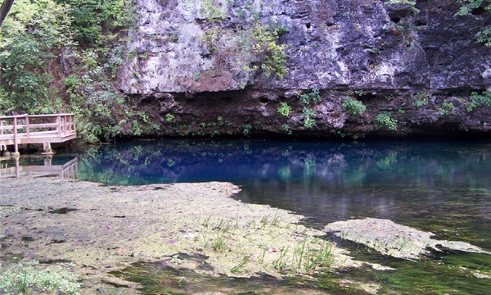
Figure 11. Protected Cliff ecological site at Blue Spring Natural Area near Eminence, Missouri; photo credit MDC.
Forest overstory.The Overstory Species list is based on field reconnaissance as well as commonly occurring species listed in Nelson 2010; names and symbols are from USDA PLANTS database.
Forest understory. The Understory Species list is based on field reconnaissance as well as commonly occurring species listed in Nelson 2010; names and symbols are from USDA PLANTS database.
State 2
Disturbed CliffThis state has experienced significant exotic plant invasion, such as Japanese honeysuckle. Repeated trampling by rock climbing and rappelling activities have destroyed the structure and composition of the reference plant communities. In addition, woody encroachment through these disturbances is also occurring.
Community 2.1
Chinkapin Oak – Eastern Redcedar/ Japanese HoneysuckleTransition T1A
State 1 to 2Exotic plant invasion; woody encroachment; rock climbing, rappelling
Restoration pathway R2A
State 2 to 1Woody removal; site protection and monitoring
Additional community tables
Table 5. Community 1.1 plant community composition
Group Common name Symbol Scientific name Annual production () Foliar cover (%) Table 6. Community 1.1 forest overstory composition
Common name Symbol Scientific name Nativity Height ft Canopy cover (%) Diameter in Basal area (square ft/acre) Treechinquapin oak QUMU Quercus muehlenbergii Native – – – 0 blue ash FRQU Fraxinus quadrangulata Native – – – 0 white ash FRAM2 Fraxinus americana Native – – – 0 sugar maple ACSA3 Acer saccharum Native – – – 0 eastern redcedar JUVI Juniperus virginiana Native – – – 0 northern red oak QURU Quercus rubra Native – – – 0 Table 7. Community 1.1 forest understory composition
Common name Symbol Scientific name Nativity Height (ft) Canopy cover (%) Grass/grass-like (Graminoids)sideoats grama BOCU Bouteloua curtipendula Native – – bristleleaf sedge CAEB2 Carex eburnea Native – – little bluestem SCSC Schizachyrium scoparium Native – – Forb/HerbDrummond's aster SYDR Symphyotrichum drummondii Native – – waxyleaf meadow-rue THRE Thalictrum revolutum Native – – zigzag goldenrod SOFL2 Solidago flexicaulis Native – – orange coneflower RUFUU Rudbeckia fulgida var. umbrosa Native – – red columbine AQCA Aquilegia canadensis Native – – wrinkleleaf goldenrod SORU2 Solidago rugosa Native – – Fern/fern allywalking fern ASRH2 Asplenium rhizophyllum Native – – bulblet bladderfern CYBU3 Cystopteris bulbifera Native – – ebony spleenwort ASPL Asplenium platyneuron Native – – purple cliffbrake PEAT2 Pellaea atropurpurea Native – – Shrub/Subshrubfragrant sumac RHAR4 Rhus aromatica Native – – wild hydrangea HYAR Hydrangea arborescens Native – – American bladdernut STTR Staphylea trifolia Native – – northern spicebush LIBE3 Lindera benzoin Native – – Nonvascularrim lichen LEMU60 Lecanora muralis Native – – false Russell's fishscale lichen PSPS3 Psora pseudorussellii Native – – Table 8. Community 2.1 plant community composition
Group Common name Symbol Scientific name Annual production () Foliar cover (%) Interpretations
Animal community
Wildlife*
Only a few animals are highly associated with cliff natural communities due to their unique structural conditions.
Bird species associated with this ecological site’s reference state condition: Turkey Vulture, Eastern Phoebe, American Kestrel, Northern Rough-winged Swallow, Cliff Swallow, and Barn Swallow.
North-facing cliffs that are wet and moist may have numerous lungless salamander (Family Plethodontidae) species and pickerel frogs (Rana palustris).
Small mammals likely associated with this ecological site’s reference state condition: Eastern Woodrat (Neotoma floridana) and Peromyscus species.
As with most natural communities, many invertebrate groups are represented on cliff natural communities including snails, spiders, insects, centipedes, millipedes and protistan microbe communities. Funnel-web and aerial web spiders are two groups well represented on cliff natural communities. Colonies of microcaddisflies and midgeflies are some of the invertebrate groups that occur on seep-type habitats created by the movement of thin sheets of water over the rock surface. Terrestrial snails are often abundant in the talus slopes that develop at the base of protected limestone/dolomite cliffs.
*This section prepared by Mike Leahy, Natural Areas Coordinator, Missouri Department of Conservation, 2013. References for this section: Fitzgerald and Pashley 2000b; Heitzman and Heitzman 1996; Jacobs 2001; Johnson 2000; Pitts and McGuire 2000; Schwartz and others 2001.Other information
Forestry
Management: This ecological site is not recommended for traditional timber production activitySupporting information
Inventory data references
Potential Reference Sites: Dolomite Protected Cliff Plot MONTSP_KS02C - Moko soil Located in Montauk State Park, Dent County, MO Latitude: 37.450237 Longitude: -91.688434 Plot ONONSP05 - Gasconade soil Located in Onondaga State Park, Crawford County, MO Latitude: 38.053143 Longitude: -91.23430858
Other references
Fitzgerald, J.A. and D.N. Pashley. 2000a. Partners in Flight bird conservation plan for the Ozark/Ouachitas. American Bird Conservancy.
Heitzman, J.R. and J.E. Heitzman. 1996. Butterflies and moths of Missouri. 2nd ed. Missouri Department of Conservation, Jefferson City.
Jacobs, B. 2001. Birds in Missouri. Missouri Department of Conservation, Jefferson City.
Johnson, T.R. 2000. The amphibians and reptiles of Missouri. 2nd ed. Missouri Department of Conservation, Jefferson City.
Kost, M.A., D.A. Albert, J.G. Cohen, B.S. Slaughter, R.K. Schillo, C.R. Weber, and K.A. Chapman. 2007. Natural Communities of Michigan: Classification and Description. Michigan Natural Features Inventory, Report No. 2007-21, Lansing, MI.
NatureServe, 2010. Vegetation Associations of Missouri (revised). NatureServe, St. Paul, Minnesota.
Nelson, Paul W. 2010. The Terrestrial Natural Communities of Missouri. Missouri Department of Conservation, Jefferson City, Missouri.
Nelson, Paul W and Douglas Ladd. 1980. “Preliminary report on the identification, distribution and classification of Missouri glades”.
Nigh, Timothy A., and Walter A. Schroeder. 2002. Atlas of Missouri Ecoregions. Missouri Department of Conservation, Jefferson City, Missouri.
Pitts, D.E. and W.D. McGuire. 2000. Wildlife management for Missouri landowners. 3rd ed. Missouri Department of Conservation, Jefferson City.
Schwartz, C.W., E.R. Schwartz and J.J. Conley. 2001. The wild mammals of Missouri. University of Missouri Press, Columbia and Missouri Department of Conservation, Jefferson City.
United States Department of Agriculture – Natural Resource Conservation Service (USDA-NRCS). 2006. Land Resource Regions and Major Land Resource Areas of the United States, the Caribbean, and the Pacific Basin. U.S. Department of Agriculture Handbook 296. 682 pgs.Contributors
Fred Young
Doug WallaceApproval
Nels Barrett, 9/24/2020
Acknowledgments
Missouri Department of Conservation and Missouri Department of Natural Resources personnel provided significant and helpful field and technical support in the development of this ecological site
Rangeland health reference sheet
Interpreting Indicators of Rangeland Health is a qualitative assessment protocol used to determine ecosystem condition based on benchmark characteristics described in the Reference Sheet. A suite of 17 (or more) indicators are typically considered in an assessment. The ecological site(s) representative of an assessment location must be known prior to applying the protocol and must be verified based on soils and climate. Current plant community cannot be used to identify the ecological site.
Author(s)/participant(s) Contact for lead author Date 09/04/2026 Approved by Approval date Composition (Indicators 10 and 12) based on Annual Production Indicators
-
Number and extent of rills:
-
Presence of water flow patterns:
-
Number and height of erosional pedestals or terracettes:
-
Bare ground from Ecological Site Description or other studies (rock, litter, lichen, moss, plant canopy are not bare ground):
-
Number of gullies and erosion associated with gullies:
-
Extent of wind scoured, blowouts and/or depositional areas:
-
Amount of litter movement (describe size and distance expected to travel):
-
Soil surface (top few mm) resistance to erosion (stability values are averages - most sites will show a range of values):
-
Soil surface structure and SOM content (include type of structure and A-horizon color and thickness):
-
Effect of community phase composition (relative proportion of different functional groups) and spatial distribution on infiltration and runoff:
-
Presence and thickness of compaction layer (usually none; describe soil profile features which may be mistaken for compaction on this site):
-
Functional/Structural Groups (list in order of descending dominance by above-ground annual-production or live foliar cover using symbols: >>, >, = to indicate much greater than, greater than, and equal to):
Dominant:
Sub-dominant:
Other:
Additional:
-
Amount of plant mortality and decadence (include which functional groups are expected to show mortality or decadence):
-
Average percent litter cover (%) and depth ( in):
-
Expected annual annual-production (this is TOTAL above-ground annual-production, not just forage annual-production):
-
Potential invasive (including noxious) species (native and non-native). List species which BOTH characterize degraded states and have the potential to become a dominant or co-dominant species on the ecological site if their future establishment and growth is not actively controlled by management interventions. Species that become dominant for only one to several years (e.g., short-term response to drought or wildfire) are not invasive plants. Note that unlike other indicators, we are describing what is NOT expected in the reference state for the ecological site:
-
Perennial plant reproductive capability:
Print Options
Sections
Font
AAAAOther
PrintThe Ecosystem Dynamics Interpretive Tool is an information system framework developed by the USDA-ARS Jornada Experimental Range, USDA Natural Resources Conservation Service, and New Mexico State University.
Accessibility statement


