
Natural Resources
Conservation Service
Ecological site F115XB028MO
Loamy/Gravelly Upland Drainageway Forest
Last updated: 12/30/2024
Accessed: 09/22/2026
-
Search


Major Land Resource Area or ecological site by name and/or ID.
PreviousSectionsNextGeneral information
Provisional. A provisional ecological site description has undergone quality control and quality assurance review. It contains a working state and transition model and enough information to identify the ecological site.
Click to explore map
Figure 1. Mapped extent
Areas shown in blue indicate the maximum mapped extent of this ecological site. Other ecological sites likely occur within the highlighted areas. It is also possible for this ecological site to occur outside of highlighted areas if detailed soil survey has not been completed or recently updated.
MLRA notes
Major Land Resource Area (MLRA): 115X–Central Mississippi Valley Wooded Slopes
This MLRA is characterized by deeply dissected, loess-covered hills bordering well defined valleys of the Illinois, Mississippi, Missouri, Ohio, and Wabash Rivers and their tributaries. It is used to produce cash crops and livestock. About one-third of the area is forested, mostly on the steeper slopes. This area is in Illinois (50 percent), Missouri (36 percent), Indiana (13 percent), and Iowa (1 percent) in two separate areas. It makes up about 25,084 square miles (64,967 square kilometers).
Most of this area is in the Till Plains section and the Dissected Till Plains section of the Central Lowland province of the Interior Plains. The Springfield-Salem plateaus section of the Ozarks Plateaus province of the Interior Highlands occurs along the Missouri River and the Mississippi River south of the confluence with the Missouri River. The nearly level to very steep uplands are dissected by both large and small tributaries of the Illinois, Mississippi, Missouri, Ohio, and Wabash Rivers. The Ohio River flows along the southernmost boundary of this area in Indiana. Well defined valleys with broad flood plains and numerous stream terraces are along the major streams and rivers. The flood plains along the smaller streams are narrow. Broad summits are nearly level to undulating. Karst topography is common in some parts along the Missouri and Mississippi Rivers and their tributaries. Well-developed karst areas have hundreds of sinkholes, caves, springs, and losing streams. In the St. Louis area, many of the karst features have been obliterated by urban development.
Elevation ranges from 90 feet (20 meters) on the southernmost flood plains to 1,030 feet (320 meters) on the highest ridges. Local relief is mainly 10 to 50 feet (3 to 15 meters) but can be 50 to 150 feet (15 to 45 meters) in the steep, deeply dissected hills bordering rivers and streams. The bluffs along the major rivers are generally 200 to 350 feet (60 to 105 meters) above the valley floor.
The uplands in this MLRA are covered almost entirely with Peoria Loess. The loess can be more than 7 feet (2 meters) thick on stable summits. On the steeper slopes, it is thin or does not occur. In Illinois, the loess is underlain mostly by Illinoian-age till that commonly contains a paleosol. Pre-Illinoian-age till is in parts of this MLRA in Iowa and Missouri and to a minor extent in the western part of Illinois. Wisconsin-age outwash, alluvial deposits, and sandy eolian material are on some of the stream terraces and on dunes along the major tributaries. The loess and glacial deposits are underlain by several bedrock systems. Pennsylvanian and Mississippian bedrock are the most extensive. To a lesser extent are Silurian, Devonian, Cretaceous, and Ordovician bedrock. Karst areas have formed where limestone is near the surface, mostly in the southern part of the MLRA along the Mississippi River and some of its major tributaries. Bedrock outcrops are common on the bluffs along the Mississippi, Ohio, and Wabash Rivers and their major tributaries and at the base of some steep slopes along minor streams and drainageways.
The annual precipitation ranges from 35 to 49 inches (880 to 1,250 millimeters) with a mean of 41 inches (1,050 millimeters). The annual temperature ranges from 48 to 58 degrees F (8.6 to 14.3 degrees C) with a mean of 54 degrees F (12.3 degrees C). The freeze-free period ranges from 150 to 220 days with a mean of 195 days.
Soils The dominant soil orders are Alfisols and, to a lesser extent, Entisols and Mollisols. The soils in the area have a mesic soil temperature regime, an aquic or udic soil moisture regime, and mixed or smectitic mineralogy. They are shallow to very deep, excessively drained to poorly drained, and loamy, silty, or clayey.
The soils on uplands in this area support natural hardwoods. Oak, hickory, and sugar maple are the dominant species. Big bluestem, little bluestem, and scattered oak and eastern redcedar grow on some sites. The soils on flood plains support mixed forest vegetation, mainly American elm, eastern cottonwood, river birch, green ash, silver maple, sweetgum, American sycamore, pin oak, pecan, and willow. Sedge and grass meadows and scattered trees are on some low-lying sites. (United States Department of Agriculture, Natural Resources Conservation Service, 2022)LRU notes
The Central Mississippi Valley Wooded Slopes, Western Part consists of deeply dissected, loess-covered hills bordering the Missouri and Mississippi Rivers as well as floodplains and terraces of these rivers. The Northern boundary runs along the South Fabius River valley separating it from the broad rounded interfluves of the northern till plain. A major physiographic feature within the LRU (Land Resource Unit) includes the Lincoln Hills region. The Lincoln Hills extend along the Mississippi River in Missouri, starting about 40 miles (64 kilometers) northwest of St. Louis and extending north to Hannibal. The Lincoln Hills partially escaped the most recent glaciation in the region during the Pleistocene. In geology and biology, they resemble the rugged and forested hills of the Ozark Highlands (MLRA 116A) more than the rolling plains of northern Missouri. The underlying limestone bedrock has formed bluffs, glades, caves, springs, and sinkholes. Elevation ranges from about 420 feet (128 meters) along the Mississippi River near Cape Girardeau, Missouri to about 830 feet (253 meters) near Clarksville along the Mississippi River upstream from St. Louis. High ridges near Hillsboro, Missouri can reach over 1,000 feet (305 meters). Underlying bedrock is mainly Ordovician-aged dolomite and sandstone, with Mississippian-aged limestone north of the Missouri River. Loess caps both stream and glacial outwash terraces along the major rivers along with Pre-Illinoisan till near the edges of the area.
Classification relationships
Major Land Resource Area (MLRA) (USDA-NRCS, 2022):
115X–Central Mississippi Valley Wooded Slopes
Terrestrial Natural Community Type in Missouri (Nelson, 2010):
The reference state for this ecological site is most similar to a Mesic Bottomland Forest.
Missouri Department of Conservation Forest and Woodland Communities (MDC, 2006):
The reference state for this ecological site is most similar to a Mixed Hardwood Mesic Bottomland Forest.
National Vegetation Classification System Vegetation Association (NatureServe, 2010):
The reference state for this ecological site is most similar to a Quercus alba - Quercus rubra - Acer saccharum - Carya cordiformis / Lindera benzoin Forest (CEGL002058).
Geographic relationship to the Missouri Ecological Classification System (Nigh & Schroeder, 2002):
This ecological site occurs primarily in Land Type Associations of the following Subsections:
Inner Ozark Border
Outer Ozark Border
Mississippi River HillsEcological site concept
Loamy/Gravelly Upland Drainageway Forests are scattered in small delineations throughout the upland portions of the MLRA and in adjacent areas. They are associated with Loamy Floodplain Riverfront Forest sites downstream, and with adjacent upland ecological sites. Soils are loamy, with abundant gravel in some places, and are subject to flooding. The reference plant community is forest with an overstory dominated by a wide variety of trees including northern red oak, sugar maple, and American elm, an understory dominated by northern spicebush and American hornbeam, and an herbaceous ground flora dominated by sedges.
Associated sites
F115XB004MO Loess Upland Woodland
Deep loess upland ecological sites, such as Loess Upland Woodlands, are typically found upslope.
F115XB017MO Sandstone Protected Backslope Forest
Steep backslope ecological sites, such as Sandstone Protected Backslope Forests, are usually found immediately upslope.
Similar sites
F115XB026MO Wet Upland Drainageway Forest
Wet Upland Drainageway Forests are also associated with upland stream systems but have species more associated with wetter sites.
Table 1. Dominant plant species
Tree (1) Quercus rubra
(2) Acer saccharumShrub (1) Carpinus caroliniana
Herbaceous (1) Viola missouriensis
(2) CarexPhysiographic features
This site is in narrow drainageways in the uplands, with slopes of 1 to 4 percent. The site receives runoff from adjacent upland sites. Most areas are subject to frequent, brief flooding.
The following figure (adapted from Skaer, 2004) shows the typical landscape position of this ecological site, and landscape relationships among the major ecological sites in the adjacent uplands. The site is within the area labeled “5”, in narrow drainageways directly adjacent to steep uplands. Sandstone stratigraphy is shown here, but Loamy/Gravelly Upland Drainageways are also associated with deep loess and limestone uplands.
Figure 2. Landscape relationships for this ecological site.
Table 2. Representative physiographic features
Landforms (1) Drainageway
Runoff class Low to high Flooding duration Very brief (4 to 48 hours) to brief (2 to 7 days) Flooding frequency Occasional to frequent Ponding frequency None Elevation 500 – 1000 ft Slope 1 – 4 % Aspect Aspect is not a significant factor Climatic features
The Central Mississippi Valley Wooded Slopes, Western Part has a continental type of climate marked by strong seasonality. In winter, dry-cold air masses, unchallenged by any topographic barriers, periodically swing south from the northern plains and Canada. If they invade reasonably humid air, snowfall and rainfall result. In summer, moist, warm air masses, equally unchallenged by topographic barriers, swing north from the Gulf of Mexico and can produce abundant amounts of rain, either by fronts or by convectional processes. In some summers, high pressure stagnates over the region, creating extended droughty periods. Spring and fall are transitional seasons when abrupt changes in temperature and precipitation may occur due to successive, fast-moving fronts separating contrasting air masses.
The Central Mississippi Valley Wooded Slopes, Western Part experiences regional differences in climates, but these differences do not have obvious geographic boundaries. Regional climates grade inconspicuously into each other. The basic gradient for most climatic characteristics is along a line diagonally crossing the MLRA from northwest to southeast. Both mean annual temperature and precipitation exhibit gradients along this line.
The average annual precipitation in most of this area is 38 to 48 inches. The average annual temperature is 53 to 57 degrees F. Mean January minimum temperature follows the northwest-to-southeast gradient. However, mean July maximum temperature shows hardly any geographic variation in the MLRA. Mean July maximum temperatures have a range of only two or three degrees across the area.
Mean annual precipitation varies along the same gradient as temperature. Seasonal climatic variations are more complex. Seasonality in precipitation is very pronounced due to strong continental influences. June precipitation, for example, averages three to four times greater than January precipitation. Most of the rainfall occurs as high-intensity, convective thunderstorms in summer. Snowfall is common in winter.
During years when precipitation comes in a fairly normal manner, moisture is stored in the top layers of the soil during the winter and early spring, when evaporation and transpiration are low. During the summer months the loss of water by evaporation and transpiration is high, and if rainfall fails to occur at frequent intervals, drought will result. Drought directly affects plant and animal life by limiting water supplies, especially at times of high temperatures and high evaporation rates.
Superimposed upon the basic MLRA climatic patterns are local topographic influences that create topoclimatic, or microclimatic variations. In regions of appreciable relief, for example, air drainage at nighttime may produce temperatures several degrees lower in valley bottoms than on side slopes. At critical times during the year, this phenomenon may produce later spring or earlier fall freezes in valley bottoms. Higher daytime temperatures of bare rock surfaces and higher reflectivity of these unvegetated surfaces may create distinctive environmental niches such as glades and cliffs. Slope orientation is an important topographic influence on climate. Summits and south-and-west-facing slopes are regularly warmer and drier than adjacent north- and-east-facing slopes. Finally, the climate within a canopied forest is measurably different from the climate of a more open grassland or savanna areas.
Source: University of Missouri Climate Center - http://climate.missouri.edu/climate.php; accessed June 2012
Land Resource Regions and Major Land Resource Areas of the United States, the Caribbean, and the Pacific Basin, United States Department of Agriculture Handbook 296 - http://soils.usda.gov/survey/geography/mlra/Table 3 Representative climatic features
Frost-free period (characteristic range) 160-170 days Freeze-free period (characteristic range) 190-210 days Precipitation total (characteristic range) 40-50 in Frost-free period (actual range) 150-180 days Freeze-free period (actual range) 180-210 days Precipitation total (actual range) 40-50 in Frost-free period (average) 160 days Freeze-free period (average) 200 days Precipitation total (average) 50 in Characteristic rangeActual rangeBarLineFigure 3. Monthly precipitation range
Characteristic rangeActual rangeBarLineFigure 4. Monthly minimum temperature range
Characteristic rangeActual rangeBarLineFigure 5. Monthly maximum temperature range
BarLineFigure 6. Monthly average minimum and maximum temperature
Figure 7. Annual precipitation pattern
Figure 8 Annual average temperature pattern
Climate stations used
-
(1) COLUMBIA U OF M [USC00231801], Columbia, MO
-
(2) JACKSON [USC00234226], Jackson, MO
-
(3) ELSBERRY 1 S [USC00232591], Elsberry, MO
-
(4) WELDON SPRING NWS [USC00238805], Saint Charles, MO
">Influencing water features
This ecological site contains first- and second-order streams, which originate from headslope positions at the upper reaches of the units, and are fed from smaller headslopes in the adjacent uplands. These streams are ephemeral in most years, with flow in the late fall, winter, and spring months, generally disappearing in the summer, or reduced to isolated pools in the lower reaches. Stream levels typically respond quickly to storm events, especially in watersheds where surface runoff is dominant. Short-duration flooding is common in many areas. Streambeds that are typically incised into the surrounding floodplain by as much as 10 feet may be a sign of an alternative state. <br />
<br />
These reaches have a high watershed recharge potential. This potential is maximized when the channel is no deeper than it’s reference geometry. Deeper channels remove water by drainage lateral effect at a high rate, sending water downstream that otherwise would have been stored in the soil matrix for slow recharge to maintain baseflow during dry periods. In addition, these upland drainageways with high permeability sands and gravels, have significant volume of flow in the lateral and longitudinal directions that is quite large, and can exceed the volume of stream flow in the active channel.Soil features
These soils have no rooting restriction. They were formed under a mixture of prairie and woodland vegetation. Parent material is alluvium. They have loam or silt loam surface horizons, and loamy subsoils that are gravelly in some soils. In places the soils are very gravelly and cobbly throughout. These soils are not affected by seasonal wetness. Soil series associated with this site include Cedargap, Dameron, Haymond, Jemerson, Kennebec, Klum, Perche, Racket, Sensabaugh, and Wilbur.
The accompanying picture of the Dameron series shows dark, loamy alluvium, underlain by stratified very gravelly sediments. Picture from Baker (1998).
Figure 9. Dameron series
Table 4. Representative soil features
Parent material (1) Alluvium
Surface texture (1) Gravelly silt loam
(2) Loam
Family particle size (1) Loamy
Drainage class Moderately well drained to well drained Permeability class Slow to moderately slow Soil depth 72 – 0 in Surface fragment cover <=3" 0 – 20 % Surface fragment cover >3" 0 – 5 % Available water capacity
(0-40in)4 – 8 in Calcium carbonate equivalent
(0-40in)Not specified Electrical conductivity
(0-40in)0 – 2 mmhos/cm Sodium adsorption ratio
(0-40in)Not specified Soil reaction (1:1 water)
(0-40in)5.2 – 7.8 Subsurface fragment volume <=3"
(Depth not specified)0 – 55 % Subsurface fragment volume >3"
(Depth not specified)0 – 20 % Ecological dynamics
Information contained in this section was developed using historical data, professional experience, field reviews, and scientific studies. The information presented is representative of very complex vegetation communities. Key indicator plants, animals and ecological processes are described to help inform land management decisions. Plant communities will differ across the MLRA because of the naturally occurring variability in weather, soils, and aspect. The Reference Plant Community is not necessarily the management goal. The species lists are representative and are not botanical descriptions of all species occurring, or potentially occurring, on this site. They are not intended to cover every situation or the full range of conditions, species, and responses for the site.
The reference plant community is a well-developed forest with a rather tall, well developed canopy (75 to 90 feet and 80 to 100 percent canopy closure), a complex understory and a dense herbaceous ground flora. These drainageways tend to be relatively high gradient with frequent annual (often multiple times in a year), flashy floods with quick rises and falls after significant rainfall events. Gaps in all three layers are common due to flash flooding.
A variety of mixed hardwood tree species, including northern red oak, sugar maple, and American elm occur over moisture loving saplings and shrubs (northern spicebush, American hornbeam) and herbaceous ground flora, especially sedges.
Typically, many upland drainageway forests still remain. They often occur as a rather narrow band of timber traversing the headwater streams, often in a matrix of upland forest. Occasionally, on wider drainageways, this ecological site is cleared and converted to cropland or pasture, with a narrow strip of woodland retained along the stream edge. In such cases, severe flooding may cause stream bank erosion and complete loss of this site.
Uncontrolled grazing by domestic livestock in the remaining strips of forest can also kill trees and remove the ground cover, resulting in de-stabilization and potential loss of this system as well. These sites are productive. Some carefully planned timber harvest can be tolerated in this system, but high grading of the timber will degrade the system.
Re-establishment of these productive drainageway forests is important for stream quality and health, as well as for migratory birds. Replanting of these systems has proven to be quite successful, and but species selection needs to pay attention to local soil and moisture conditions.
A State and Transition Diagram follows. Detailed descriptions of each state, transition, plant community, and pathway follow the model. This model is based on available experimental research, field observations, professional consensus, and interpretations. It is likely to change as knowledge increases.State and transition model
Custom diagramStandard diagram
Figure 10. State and transition diagram for this ecological site
More interactive model formats are also available. View Interactive Models
More interactive model formats are also available. View Interactive Models
Click on state and transition labels to scroll to the respective textEcosystem states
SWAPAEHSWAPAEHSWAPAEHSWAPAEHStates 1 and 5 (additional transitions)
SWAPAEHState 2 submodel, plant communities
State 3 submodel, plant communities
State 4 submodel, plant communities
State 5 submodel, plant communities
State 1
ReferenceThe reference state was dominated by northern red oak and sugar maple including a wide variety of other deciduous hardwood tree species. Maximum tree age was likely 150 to 300 years. Periodic disturbances from fire, wind or occurred along with infrequent flooding. Long disturbance-free periods allowed an increase in more shade tolerant species such as bitternut hickory and sugar maple. Two community phases are recognized in this state, with shifts between phases based on disturbance frequency.
Dominant plant species
-
northern red oak (Quercus rubra), tree
-
sugar maple (Acer saccharum), tree
-
bitternut hickory (Carya cordiformis), tree
-
hophornbeam (Ostrya virginiana), tree
-
sedge (Carex), grass
-
Missouri violet (Viola missouriensis), other herbaceous
Community 1.1
Northern Red Oak – Sugar Maple/American Hornbeam/Missouri Violet – Sedge
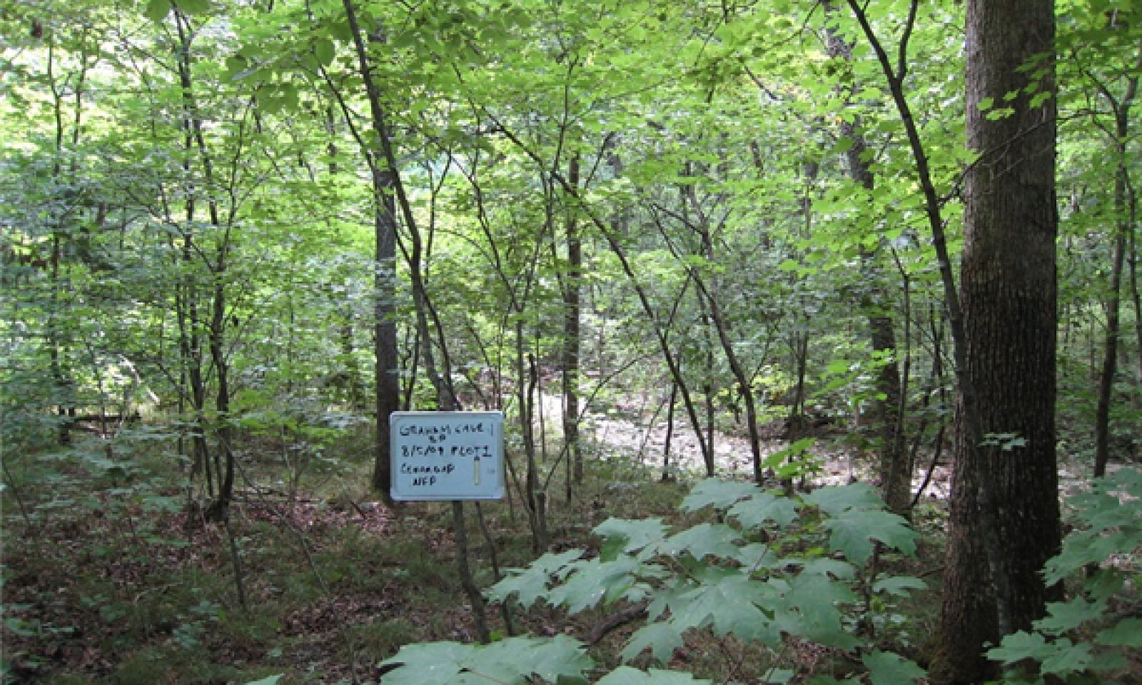
Figure 11. Graham Cave State Park, Montgomery County, Missouri; photo credit MDC
This phase is an old growth forest dominated by an overstory of northern red oak and sugar maple. The canopy and understory are well developed with great structural and species diversity. This phase experiences flooding but of short duration.
Forest overstory.Forest Overstory Composition species list is based on Nelson (2010) and field surveys.
Forest understory. Forest Understory Composition species list is based on Nelson (2010) and field surveys.
Community 1.2
Northern Red Oak – Sugar Maple/Bitternut Hickory Saplings – American Hornbeam/Missouri Violet – SedgeLong disturbance-free periods allows an increase in more shade tolerant species such as bitternut hickory, and sugar maple with increased canopy density, which affects the abundance and diversity of ground flora.
Pathway P1.1A
Community 1.1 to 1.2This community pathway is the result of no disturbances for 10+ years.
Pathway P1.2A
Community 1.2 to 1.1This community pathway is the result of disturbances (fire, wind, ice) reoccurring every 3 to 5 years.
State 2
CroplandOccasionally, on wider drainageways, this ecological site is cleared and converted to cropland with a narrow strip of woodland retained along the stream edge. Major crops include corn, soybeans and wheat.
Community 2.1
Corn, Soybeans, WheatThis is a common phase that exists currently with intensive cropping of corn, soybeans, and wheat occurring. Some conversion to cool season grassland occurs for a limited period of time before transitioning back to cropland.
State 3
Managed ForestManaged forests can resemble the reference state but are denser. The biggest differences are tree age, most being only 50 to 90 years old, and canopy closure. Composition is also likely altered from the reference state depending on tree selection during harvest. In addition, without a regular 15 to 20 year harvest re-entry into these stands, they will slowly increase in more shade tolerant species such as bitternut hickory and sugar maple and northern red oak will become less dominant.
Dominant plant species
-
sugar maple (Acer saccharum), shrub
-
northern red oak (Quercus rubra), shrub
-
bitternut hickory (Carya cordiformis), shrub
-
shellbark hickory (Carya laciniosa), shrub
-
flowering dogwood (Cornus florida), shrub
-
Indian woodoats (Chasmanthium latifolium), grass
Community 3.1
Sugar Maple – Northern Red Oak – Hickory/Flowering Dogwood/Indian WoodoatsThis is the only phase associated with this state at this time. See the corresponding state narrative for details.
State 4
GrasslandConversion of forests to planted, non-native cool season grassland species such as tall fescue and red clover has been common in this region. High grain commodity prices will encourage transition to State 2 (Cropland).
Dominant plant species
-
tall fescue (Schedonorus arundinaceus), grass
-
red clover (Trifolium pratense), other herbaceous
Community 4.1
Tall Fescue – Red CloverThis phase is a well-managed grassland, composed of non-native cool season grasses and legumes. Grazing and haying is occurring. The effects of long-term liming on soil pH, and calcium and magnesium content, is most evident in this phase. Studies show that these soils have higher pH and higher base status in soil horizons as much as two feet below the surface, relative to poorly managed grassland and to woodland communities (where liming is not practiced).
State 5
High-Graded/Grazed WoodlandForested sites subjected to repeated, high-graded timber harvests and uncontrolled domestic grazing transition to this state. This state exhibits an over-abundance of hickory and other less desirable tree species, and weedy understory species such as buckbrush, gooseberry, poison ivy and Virginia creeper. The vegetation offers little nutritional value for cattle, and excessive stocking damages tree boles, degrades understory species composition and results in soil compaction and accelerated erosion and runoff.
Dominant plant species
-
common hackberry (Celtis occidentalis), tree
-
bitternut hickory (Carya cordiformis), tree
-
shellbark hickory (Carya laciniosa), tree
-
Ohio buckeye (Aesculus glabra), tree
-
coralberry (Symphoricarpos orbiculatus), shrub
Community 5.1
Hackberry – Hickory/ Ohio Buckeye/CoralberryThis is the only phase associated with this state at this time. See the corresponding state narrative for details.
Transition T1A
State 1 to 2This transition is the result of clearing, tillage and conservation cropping system.
Transition T1B
State 1 to 3This transition is the result of timber harvesting and forest stand improvement.
Transition T1C
State 1 to 4This transition is the result of clearing, grassland planting and grassland management.
Transition T1D
State 1 to 5Poorly planned harvests (high-grading) and uncontrolled grazing will result this transition.
Transition T2A
State 2 to 4This transition is the result of grassland planting and grassland management.
Restoration pathway R1A
State 3 to 1This restoration pathway is the result of extended rotations and forest stand improvement.
Transition T3A
State 3 to 4This transition is the result of clearing, tillage and conservation cropping system.
Restoration pathway T4A
State 4 to 2This transition is the result of tillage and conservation cropping system.
Restoration pathway T5B
State 5 to 3This transition is the result of forest stand improvement, tree planting and livestock exclusion.
Transition T5A
State 5 to 4Clearing, pasture planting and prescribed grazing will result in this transition.
Additional community tables
Table 5. Community 1.1 plant community composition
Group Common name Symbol Scientific name Annual production () Foliar cover (%) Table 6. Community 1.1 forest overstory composition
Common name Symbol Scientific name Nativity Height ft Canopy cover (%) Diameter in Basal area (square ft/acre) Treecommon hackberry CEOC Celtis occidentalis Native – – – 0 black walnut JUNI Juglans nigra Native – – – 0 eastern redcedar JUVI Juniperus virginiana Native – – – 0 American sycamore PLOC Platanus occidentalis Native – – – 0 white ash FRAM2 Fraxinus americana Native – – – 0 sugar maple ACSA3 Acer saccharum Native – – – 0 bitternut hickory CACO15 Carya cordiformis Native – – – 0 white oak QUAL Quercus alba Native – – – 0 northern red oak QURU Quercus rubra Native – – – 0 American elm ULAM Ulmus americana Native – – – 0 chinquapin oak QUMU Quercus muehlenbergii Native – – – 0 slippery elm ULRU Ulmus rubra Native – – – 0 bur oak QUMA2 Quercus macrocarpa Native – – – 0 silver maple ACSA2 Acer saccharinum Native – – – 0 shellbark hickory CALA21 Carya laciniosa Native – – – 0 Table 7. Community 1.1 forest understory composition
Common name Symbol Scientific name Nativity Height (ft) Canopy cover (%) Grass/grass-like (Graminoids)rock muhly MUSO Muhlenbergia sobolifera Native – – Virginia wildrye ELVI3 Elymus virginicus Native – – nodding fescue FESU3 Festuca subverticillata Native – – richwoods sedge CAOL2 Carex oligocarpa Native – – Indian woodoats CHLA5 Chasmanthium latifolium Native – – eastern woodland sedge CABL Carex blanda Native – – Bosc's panicgrass DIBO2 Dichanthelium boscii Native – – parasol sedge CAUM4 Carex umbellata Native – – Forb/HerbCanadian woodnettle LACA3 Laportea canadensis Native – – biannual lettuce LALU Lactuca ludoviciana Native – – early meadow-rue THDI Thalictrum dioicum Native – – stalked wild petunia RUPE4 Ruellia pedunculata Native – – bloodroot SACA13 Sanguinaria canadensis Native – – elmleaf goldenrod SOUL2 Solidago ulmifolia Native – – common blue wood aster SYCO4 Symphyotrichum cordifolium Native – – pointedleaf ticktrefoil DEGL5 Desmodium glutinosum Native – – cutleaf coneflower RULA3 Rudbeckia laciniata Native – – beaked agrimony AGRO3 Agrimonia rostellata Native – – yellow passionflower PALU2 Passiflora lutea Native – – violet lespedeza LEVI6 Lespedeza violacea Native – – largebract ticktrefoil DECU Desmodium cuspidatum Native – – cutleaf toothwort CACO26 Cardamine concatenata Native – – white avens GECA7 Geum canadense Native – – feathery false lily of the valley MARA7 Maianthemum racemosum Native – – lateflowering thoroughwort EUSE2 Eupatorium serotinum Native – – licorice bedstraw GACI2 Galium circaezans Native – – common yellow oxalis OXST Oxalis stricta Native – – Canadian wildginger ASCA Asarum canadense Native – – eastern waterleaf HYVI Hydrophyllum virginianum Native – – wingstem VEAL Verbesina alternifolia Native – – Fern/fern allyChristmas fern POAC4 Polystichum acrostichoides Native – – lowland bladderfern CYPR4 Cystopteris protrusa Native – – Shrub/SubshrubCarolina buckthorn FRCA13 Frangula caroliniana Native – – coralberry SYOR Symphoricarpos orbiculatus Native – – fragrant sumac RHAR4 Rhus aromatica Native – – pawpaw ASTR Asimina triloba Native – – eastern leatherwood DIPA9 Dirca palustris Native – – Treehophornbeam OSVI Ostrya virginiana Native – – Ohio buckeye AEGL Aesculus glabra Native – – common persimmon DIVI5 Diospyros virginiana Native – – flowering dogwood COFL2 Cornus florida Native – – American hornbeam CACA18 Carpinus caroliniana Native – – Vine/Lianacat greenbrier SMGL Smilax glauca Native – – Table 8. Community 1.2 plant community composition
Group Common name Symbol Scientific name Annual production () Foliar cover (%) Table 9. Community 2.1 plant community composition
Group Common name Symbol Scientific name Annual production () Foliar cover (%) Table 10. Community 3.1 plant community composition
Group Common name Symbol Scientific name Annual production () Foliar cover (%) Table 11. Community 4.1 plant community composition
Group Common name Symbol Scientific name Annual production () Foliar cover (%) Table 12. Community 5.1 plant community composition
Group Common name Symbol Scientific name Annual production () Foliar cover (%) Interpretations
Animal community
Wildlife (MDC 2006):
Wild turkey, white-tailed deer, and eastern gray squirrel depend on hard and soft mast food sources and are typical upland game species of this type.
Birds associated with mid-successional stages include Whip-poor-will and Wood Thrush while birds associated with late-successional stages include Worm-eating warbler, Whip-poor-will, Great Crested Flycatcher, Ovenbird, Pileated Woodpecker, Wood Thrush, Red-eyed Vireo, Northern Parula, Louisiana Waterthrush (near streams), and Broad-winged Hawk.
Reptile and amphibian species associated with mature forests include: ringed salamander, spotted salamander, marbled salamander, central newt, long-tailed salamander, dark-sided salamander, southern red-backed salamander, three-toed box turtle, western worm snake, western earth snake, and American toad.Other information
Forestry (NRCS 2002, 2014):
Management: Estimated site index values range from 60 to 70 for oak. Timber management opportunities are good. Create group openings of at least 2 acres. Large clearcuts should be minimized if possible to reduce impacts on wildlife and aesthetics. Uneven-aged management using single tree selection or small group selection cuttings of ½ to 1 acre are other options that can be used if clear cutting is not desired or warranted. Maintain adequate riparian buffer areas.
Limitations: No major limitations or restrictions. Occasional periods of seasonal wetness; Use of equipment may be restricted in spring and other excessively wet periods. Equipment use when wet may compact soil and damage tree roots. Tree planting may be difficult during spring flooding periods.Supporting information
Inventory data references
Potential Reference Sites: Loamy/Gravelly Upland Drainageway Forest Loamy phase Plot DIGGCA01 - Moniteau soil Located in Marshall Diggs CA, Audrain County, MO Latitude: 39.07874 Longitude: -91.63387 Plot BAWIUM02 - Dameron soil Located in Baskett Wilderness Area, Boone County, MO Latitude: 38.736083 Longitude: -92.206152 Plot DOROSP03 – Perche soil Located in Don Robinson State Park, Jefferson County, MO Latitude: 38.398376 Longitude: -90.70243 Plot DOROSP09 - Perche soil Located in Don Robinson State Park, Jefferson County, MO Latitude: 38.398186 Longitude: -90.702516 Gravelly phase Plot BAWIUM03 - Cedargap soil Located in Baskett Wilderness Area, Boone County, MO Latitude: 38.745015 Longitude: -92.208249 Plot DABOCA_JK19 – Cedargap soil Located in Daniel Boone CA, Warren County, MO Latitude: 38.792166 Longitude: -91.38311 Plot DABOCA06 – Cedargap soil Located in Daniel Boone CA, Warren County, MO Latitude: 38.772365 Longitude: -91.37764 Plot DANVCA_JK14 – Cedargap soil Located in Danville CA, Montgomery County, MO Latitude: 38.875214 Longitude: -91.53925836 Plot DANVCA05 – Cedargap soil Located in Danville CA, Montgomery County, MO Latitude: 38.885563 Longitude: -91.544783 Plot GRCASP12 – Cedargap soil Located in Graham Cave State Park, Montgomery County, MO Latitude: 38.905589 Longitude: -91.572497
Other references
Batek, M.J., A.J. Rebertus, W.A. Schroeder, T.L. Haithcoat, E. Compas, and R.P. Guyette. 1999. Reconstruction of early nineteenth-century vegetation and fire regimes in the Missouri Ozarks. Journal of Biogeography 26:397-412.
Brinson, M.M. 1993. A hydrogeomorphic classification for wetlands. Technical Report WRP-DE-4, U.S. Army Corps of Engineers, Engineer Waterways Experiment Station, Vicksburg, MS.
Cowardin, L.M., V. Carter, F.C. Golet, & E.T. LaRoe. 1979. Classification of wetlands and deepwater habitats of the United States. U.S. Dept. of Interior, Fish & Wildlife Service, Office of Biological Services, Washington DC.
Frost, C., 1996. Pre-settlement Fire Frequency Regimes of the United States: A First Approximation. Pages 70-81, Proceedings of the 20nd Tall Timbers Fire Ecology Conference: Fire in Ecosystem Management: Shifting the Paradigm from Suppression to Prescription. Tall Timbers Research Station, Tallahassee, FL.
Harlan, J.D., T.A. Nigh and W.A. Schroeder. 2001. The Missouri original General Land Office survey notes project. University of Missouri, Columbia.
Ladd, D. 1991. Reexamination of the role of fire in Missouri oak woodlands. Pp. 67-80 in G.V. Brown, James K.; Smith, Jane Kapler, eds. 2000. Wildland fire in ecosystems: effects of fire on flora. Gen. Tech. Rep. RMRS-GTR-42-vol. 2. Ogden, UT: U.S. Department of Agriculture, Forest Service, Rocky Mountain Research Station. 257 p.
MDC, 2006. Missouri Forest and Woodland Community Profiles. Missouri Department of Conservation, Jefferson City, Missouri.
Natural Resources Conservation Service. 2002. Woodland Suitability Groups. Missouri FOTG, Section II, Soil Interpretations and Reports. 30 pgs.
Natural Resources Conservation Service. Site Index Reports. Accessed May 2014. https://esi.sc.egov.usda.gov/ESI_Forestland/pgFSWelcome.aspx
NatureServe, 2010. Vegetation Associations of Missouri (revised). NatureServe, St. Paul, Minnesota.
Nelson, Paul W. 2010. The Terrestrial Natural Communities of Missouri. Missouri Department of Conservation, Jefferson City, Missouri.
Nigh, Timothy A. and Walter A. Schroeder. 2002. Atlas of Missouri Ecoregions. Missouri Department of Conservation, Jefferson City, Missouri.
Skaer, David M. 2004. Soil Survey of Jefferson County, Missouri. U.S. Dept. of Agric. Natural Resources Conservation Service.
United States Department of Agriculture – Natural Resource Conservation Service (USDA-NRCS). 2006. Land Resource Regions and Major Land Resource Areas of the United States, the Caribbean, and the Pacific Basin. U.S. Department of Agriculture Handbook 296. 682 pgs.
United States Department of Agriculture, Natural Resources Conservation Service. 2022. Land resource regions and major land resource areas of the United States, the Caribbean, and the Pacific Basin. U.S. Department of Agriculture, Agriculture Handbook 296.
University of Missouri Climate Center - http://climate.missouri.edu/climate.php; accessed June 2012Contributors
Fred Young
Doug WallaceApproval
Suzanne Mayne-Kinney, 12/30/2024
Acknowledgments
Missouri Department of Conservation and Missouri Department of Natural Resources personnel provided significant and helpful field and technical support in the development of this ecological site.
Rangeland health reference sheet
Interpreting Indicators of Rangeland Health is a qualitative assessment protocol used to determine ecosystem condition based on benchmark characteristics described in the Reference Sheet. A suite of 17 (or more) indicators are typically considered in an assessment. The ecological site(s) representative of an assessment location must be known prior to applying the protocol and must be verified based on soils and climate. Current plant community cannot be used to identify the ecological site.
Author(s)/participant(s) Contact for lead author Date 09/22/2026 Approved by Approval date Composition (Indicators 10 and 12) based on Annual Production Indicators
-
Number and extent of rills:
-
Presence of water flow patterns:
-
Number and height of erosional pedestals or terracettes:
-
Bare ground from Ecological Site Description or other studies (rock, litter, lichen, moss, plant canopy are not bare ground):
-
Number of gullies and erosion associated with gullies:
-
Extent of wind scoured, blowouts and/or depositional areas:
-
Amount of litter movement (describe size and distance expected to travel):
-
Soil surface (top few mm) resistance to erosion (stability values are averages - most sites will show a range of values):
-
Soil surface structure and SOM content (include type of structure and A-horizon color and thickness):
-
Effect of community phase composition (relative proportion of different functional groups) and spatial distribution on infiltration and runoff:
-
Presence and thickness of compaction layer (usually none; describe soil profile features which may be mistaken for compaction on this site):
-
Functional/Structural Groups (list in order of descending dominance by above-ground annual-production or live foliar cover using symbols: >>, >, = to indicate much greater than, greater than, and equal to):
Dominant:
Sub-dominant:
Other:
Additional:
-
Amount of plant mortality and decadence (include which functional groups are expected to show mortality or decadence):
-
Average percent litter cover (%) and depth ( in):
-
Expected annual annual-production (this is TOTAL above-ground annual-production, not just forage annual-production):
-
Potential invasive (including noxious) species (native and non-native). List species which BOTH characterize degraded states and have the potential to become a dominant or co-dominant species on the ecological site if their future establishment and growth is not actively controlled by management interventions. Species that become dominant for only one to several years (e.g., short-term response to drought or wildfire) are not invasive plants. Note that unlike other indicators, we are describing what is NOT expected in the reference state for the ecological site:
-
Perennial plant reproductive capability:
Print Options
Sections
Font
AAAAOther
PrintThe Ecosystem Dynamics Interpretive Tool is an information system framework developed by the USDA-ARS Jornada Experimental Range, USDA Natural Resources Conservation Service, and New Mexico State University.
Accessibility statement


