
Natural Resources
Conservation Service
Ecological site R112XY105OK
Shallow Sandstone Upland
Last updated: 11/05/2024
Accessed: 09/14/2026
-
Search


Major Land Resource Area or ecological site by name and/or ID.
PreviousSectionsNextGeneral information
Provisional. A provisional ecological site description has undergone quality control and quality assurance review. It contains a working state and transition model and enough information to identify the ecological site.
MLRA notes
Major Land Resource Area (MLRA): 112X–Cherokee Prairies
MLRA 112 (Cherokee Prairies) is in Kansas (48 percent), Oklahoma (29 percent), and Missouri (23 percent) makes up about 20,885 square miles (54,092 square kilometers).
This area is in the Osage Plains Section of the Central Lowland Province of the Interior Plains. It is a gently sloping to rolling dissected plains. Elevation ranges from 120 to 1,540 feet (30 to 470 meters). Even though the area is thoroughly dissected, local relief typically is only 3 to 10 feet (1 to 3 meters) and major valleys generally are less than 8 feet (25 meters) below the adjacent uplands.
The extent of the major hydrologic unit area is made up of major rivers such as the Neosho, Verdigris, Osage, and Marais des Cygnes. The Harry Truman reservoir lies in the western part of Lake of the Ozarks in Missouri and is on the Osage and Grand Rivers.
This area is dominantly underlain by Pennsylvanian and in some areas, Permian and Mississippian sandstone, shale, and limestone bedrock. The northern part of the area has a thin mantle of loess. The dominant soils within this region are Mollisols and Entisols. Alfisols occur in the eastern part of the MLRA. There are small areas of Vertisols throughout the MLRA. It also contains small areas of Vertisols. Soils in this region are developed in residuum, loess, colluvium, and alluvium. These soils were developed under big bluestem, little bluestem, Indiangrass, and switchgrass on the western part of this area. The eastern part of the area and the valleys in the western part support hardwoods, mainly northern red oak, white oak, and shagbark hickory with islands of tall prairie grasses being common. Major wildlife species of this area are deer, cottontail rabbit, fox squirrel, and bobwhite quail.
This MLRA is mostly rangeland, hayland, and pasture. More than two-fifths of the area supports pasture grasses and legumes. The western part of this area generally supports tall prairie grasses. Big bluestem, little bluestem, Indiangrass, and switchgrass are the main species. The cropland is used to produce winter wheat, soybeans, corn, grain sorghum, and other feed grains. The forested areas are mainly on steep valley sides and in low-lying areas on flood plains.Classification relationships
U.S. Department of Agriculture
Major Land Resource Area (MLRA) 112 - Cherokee Prairies
US Forest Service Ecoregions (1994-1995):
Domain name: Humid Temperate Domain
Division name: Prairie Division
Province name: Prairie Parkland (Temperate) Province
Province code: 251
Terrestrial Natural Community Type in Missouri (Nelson, 2010):
The reference state for this ecological site is most similar to a Sandstone Glade.
National Vegetation Classification System Vegetation Association (NatureServe, 2010):
The reference state for this ecological site is most similar to Schizachrium scoparium-Aristida dichotoma-Croton willdenowii/Lichens Wooded Herbaceous Vegetation (CEGL002242).
Geographic relationship to the Missouri Ecological Classification System (Nigh & Schroeder, 2002): This ecological site occurs throughout the Cherokee Plains Subsection, and in southern Land Type Associations of the Scarped Osage Plains Subsection.
NatureServe (2018):
Class: Shrub & Herb Vegetation
Subclass: Temperate & Boreal Grassland & Shrubland
Formation: Temperate Grassland & Shrubland
Division: Central North American Grassland & Shrubland
Macrogroup: Central Lowlands Tallgrass Prairie
Group: Central Tallgrass Prairie
Alliance: Central Dry & Dry-Mesic Tallgrass PrairieEcological site concept
Shallow Sandstone Uplands are located on upland shoulders and backslopes of hills and ridges. Soils that make up this site are shallow (less than 20 inches) to sandstone bedrock with greater than 45% sand in the profile. This site is often located on narrow escarpment-like bands on hillslope landforms and commonly located adjacent to and in conjunction with the Loamy Upland and Clayey Upland ecological sites.
Associated sites
R112XY102KS Clayey Upland
The Clayey Upland ecological site is on similar landform positions to the Shallow Sandstone Upland ecological site. This site is made up of poorly to moderately well drained soils with silt loam to silty clay surface layers and clayey subsoils. It has a parent material of loess over residuum and residuum from limestone and shale. It is generally on a slope range of 1 to 15 percent.
R112XY103KS Loamy Upland
The Loamy Upland ecological site is on similar landform positions to the Shallow Sandstone Upland ecological site. This site is made up of somewhat poorly to well drained soils with silt loam, loam, and silty clay loam surface layers and has a parent material of loess over residuum and residuum from limestone, sandstone, and shale. It is generally on a slope range of 1 to 15 percent.
Similar sites
R112XY106OK Shallow Limestone Upland
The Shallow Limestone Upland ecological site is similar to the Shallow Sandstone Upland ecological site because they have similar general species present. However, the Shallow Limestone Upland formed from residuum from limestone.
Table 1. Dominant plant species
Tree Not specified
Shrub Not specified
Herbaceous (1) Andropogon gerardii
Physiographic features
The Shallow Sandstone ecological site is located on upland shoulders and backslopes of hills and ridges with slopes that range from 2 to 30 percent. This site generates runoff to adjacent downslope ecological sites and some locations receives runoff from upslope summit and shoulder sites. This ecological site does not flood.
Table 2. Representative physiographic features
Landforms (1) Upland > Hill
(2) Upland > Ridge
Runoff class High to very high Flooding frequency None Ponding frequency None Elevation 495 – 1500 ft Slope 2 – 30 % Water table depth 80 – 0 in Aspect W, NW, N, NE, E, SE, S, SW Climatic features
MLRA 112 (Cherokee Prairies) has a continental climate marked by strong seasonality. In winter, dry-cold air masses periodically swing south from the northern plains and Canada. If they invade reasonably humid air, snowfall and rainfall result. In summer, moist, warm air masses swing north from the Gulf of Mexico and can produce abundant amounts of rain, either by fronts or by convectional processes. In some summers, high pressure stagnates over the region, creating extended droughty periods. Spring and fall are transitional seasons when abrupt changes in temperature and precipitation may occur due to successive, fast-moving fronts separating contrasting air masses. Seasonality in precipitation is very pronounced due to strong continental influences. June precipitation, for example, averages three to four times greater than January precipitation. During years when precipitation comes in a fairly normal manner, moisture is stored in the top layers of the soil during the winter and early spring, when evaporation and transpiration are low. During the summer months the loss of water by evaporation and transpiration is high, and if rainfall fails to occur at frequent intervals, drought will result. Drought directly influences ecological communities by limiting water supplies, especially at times of high temperatures and high evaporation rates.
The annual precipitation ranges from 36 to 48 inches (900 to 1,230 millimeters) with a mean of 43 inches (1,080 millimeters). The annual temperature ranges from 53 to 62 degrees F (11.9 to 16.5 degrees C) with a mean of 57 degrees F (13.6 degrees C). The freeze-free period ranges from 190 to 245 days with a mean of 205 days. Source: United States Department of Agriculture, Natural Resources Conservation Service. 2022. Land resource regions and major land resource areas of the United States, the Caribbean, and the Pacific Basin. U.S. Department of Agriculture, Agriculture Handbook 296.
Representative climatic features shown in Table 3 were derived from the climate stations selected for use within the MLRA.Table 3 Representative climatic features
Frost-free period (characteristic range) 170-190 days Freeze-free period (characteristic range) 190-220 days Precipitation total (characteristic range) 40-50 in Frost-free period (actual range) 160-200 days Freeze-free period (actual range) 190-220 days Precipitation total (actual range) 40-50 in Frost-free period (average) 180 days Freeze-free period (average) 200 days Precipitation total (average) 40 in Characteristic rangeActual rangeBarLineFigure 1. Monthly precipitation range
Characteristic rangeActual rangeBarLineFigure 2. Monthly minimum temperature range
Characteristic rangeActual rangeBarLineFigure 3. Monthly maximum temperature range
BarLineFigure 4. Monthly average minimum and maximum temperature
Figure 5. Annual precipitation pattern
Figure 6 Annual average temperature pattern
Climate stations used
-
(1) ELDORADO SPRINGS [USC00232511], El Dorado Springs, MO
-
(2) NOWATA [USC00346485], Nowata, OK
-
(3) PRYOR [USC00347309], Pryor, OK
-
(4) WAGONER [USC00349247], Wagoner, OK
-
(5) CLAREMORE 2 ENE [USC00341828], Claremore, OK
-
(6) MUSKOGEE [USC00346130], Muskogee, OK
-
(7) BARTLESVILLE F P FLD [USW00003959], Bartlesville, OK
-
(8) TULSA INTL AP [USW00013968], Tulsa, OK
-
(9) HOLDENVILLE 2SSE [USC00344235], Holdenville, OK
-
(10) NEVADA WTP [USC00235987], Nevada, MO
-
(11) INDEPENDENCE [USC00143954], Independence, KS
">Influencing water features
These sites are not influenced by wetland or riparian water features.
Soil features
Soils that make up the Shallow Sandstone Upland ecological site are underlain with hard or soft sandstone bedrock at a depth less than 20 inches. The soils are classified as loamy that were formed under prairie vegetation and have dark, organic-rich surface horizons. The parent material is sandstone residuum. The soil series associated with this site include Collinsville and Coweta.
Table 4. Representative soil features
Parent material (1) Residuum – sandstone
Surface texture (1) Loam
(2) Fine sandy loam
Family particle size (1) Loamy
Drainage class Well drained to somewhat excessively drained Permeability class Moderate to moderately rapid Soil depth 4 – 20 in Surface fragment cover <=3" 4 – 10 % Surface fragment cover >3" 0 – 4 % Available water capacity
(0-40in)2 – 3 in Calcium carbonate equivalent
(0-40in)Not specified Electrical conductivity
(0-40in)0 – 2 mmhos/cm Sodium adsorption ratio
(0-40in)Not specified Soil reaction (1:1 water)
(0-40in)4.5 – 6.5 Subsurface fragment volume <=3"
(Depth not specified)4 – 20 % Subsurface fragment volume >3"
(Depth not specified)0 – 14 % Ecological dynamics
The Shallow Sandstone Upland ecological site contains dominant grasses which include little bluestem, broomsedge bluestem, and Indiangrass. The glade and prairie complexes range from wide open grassy areas to widely scattered blackjack areas. The wide open grassy areas consist of very shallow soils and bare bedrock. The scattered blackjack oaks are located on a slightly deeper soil range of the soil component. Trees found on and near glades are often stunted and express poor development because of shallow droughty soils and poor growing conditions. These sites are frequently found on gentle slopes facing stream valleys where they are imbedded in a matrix of sandstone and shale parent materials.
The state and transition model is provided to diagram the complex interactions briefly discussed here. The model includes states, plant communities, transitions, and restoration pathways detailing what experts have gathered from available experimental research, field observations, professional consensus, and interpretations. There may be other states or plant communities, with additional transitions and restoration pathways, not shown in the model, as well as noticeable variations within those illustrated.
The state and transition model consists of five states and six community phases. These states and community phases interact based on the timing, intensity, and frequency of prescribe burning and prescribed grazing, introduction of invasive species, and management practices. Periodic fire is important in the maintenance of this site. The Shallow Sandstone Uplands Reference State (1) typically burned at least once every three years. These periodic fires removed excessive litter, stimulated growth and flowering of the grasses and forbs, and controlled the growth and spread of trees. Fire tolerant blackjack oak occupied islands and edges of the deeper soils, creating a complex mosaic of open glade low-density woodland, and prairie. During fire-free intervals, woody species can become a dominant influence in the plant community. Once established, blackjack oak and sumac can quickly dominate a glade and prairie ecosystem, especially if grazing has removed fuel load and the vigor of the diverse flora.
The Woody Invaded State (2) is characterized by a fire frequency and return interval greater than 20 years and a canopy cover percent between 40 and 60 percent. The Degraded Native State (3) consists of sites that have been overgrazed and degraded. The Invasive Herbaceous State (4) is characterized by invasive, non-native grasses and forbs. The Pastureland State (5) is characterized by seeded grasses, usually cool season, that receive fertilizer and irrigation inputs to maintain the pasture, often used for grazing.State and transition model
More interactive model formats are also available. View Interactive Models
Click on state and transition labels to scroll to the respective textStates 1 and 5 (additional transitions)
T1A - Fire suppression greater than 20 years. T1B - Uncontrolled grazing T1C - Invaded by non-native grasses and forbs T1D - Seeding of grasses and pasture management R2A - Cedar removal; prescribed fire. State 1 submodel, plant communities
1.1A - Fire free interval of 5-10 years 1.2A - Fire intervals 3-5 years. State 2 submodel, plant communities
State 3 submodel, plant communities
State 4 submodel, plant communities
State 5 submodel, plant communities
State 1
ReferenceThe Reference State is dominated by warm-season perennial grasses, a composite of predominantly native species of tallgrasses and midgrasses, interspersed with numerous perennial forbs. A small component of shrubs and cool-season grasses also occur. This state has two plant community phases that are dynamic in nature and are dependent on fire frequency and grazing impacts.
Characteristics and indicators. An introduction and/or increase of woody plants can occur in the Reference State and initiates the transition to the Woody Invaded State. The lengthening of fire return interval, lack of fire intensity, and lack of competition from the warm-season perennial grasses, the greater chance of woody species to establish and increase. Within the Reference State, the woody vegetation will generally be less than 15 percent canopy cover per acre. Sites that have been continuously overgrazed will transition to the Degraded Native State. An introduction of seed from introduced, invasive or noxious plants can occur in the Reference State and is the starting point for transition to the Pastureland and/or Invasive Herbaceous State. If introduced, invasive, or noxious plants are present, they should not exceed those percentages shown in the plant communities identified in the Pastureland State and Invasive Herbaceous State.
Resilience management. The Reference State is maintained through fire, grazing, and management. Fire will have a return interval of one to three years that includes the timing and intensity to negatively impact undesirable species. Grazing will include a forage-animal balance and adaptive decision-making to ensure the dominant plants within the reference plant community can maintain vigor. Management will include strategies to prevent non-native seed introduction (woody or herbaceous) and scouting with targeted control methods if initial establishment occurs.
Dominant plant species
-
blackjack oak (Quercus marilandica), tree
-
post oak (Quercus stellata), tree
-
eastern redcedar (Juniperus virginiana), tree
-
smooth sumac (Rhus glabra), shrub
-
coralberry (Symphoricarpos orbiculatus), shrub
-
little bluestem (Schizachyrium scoparium), grass
-
big bluestem (Andropogon gerardii), grass
-
Indiangrass (Sorghastrum nutans), grass
-
switchgrass (Panicum virgatum), grass
-
Michaux's croton (Croton michauxii), other herbaceous
Community 1.1
Reference
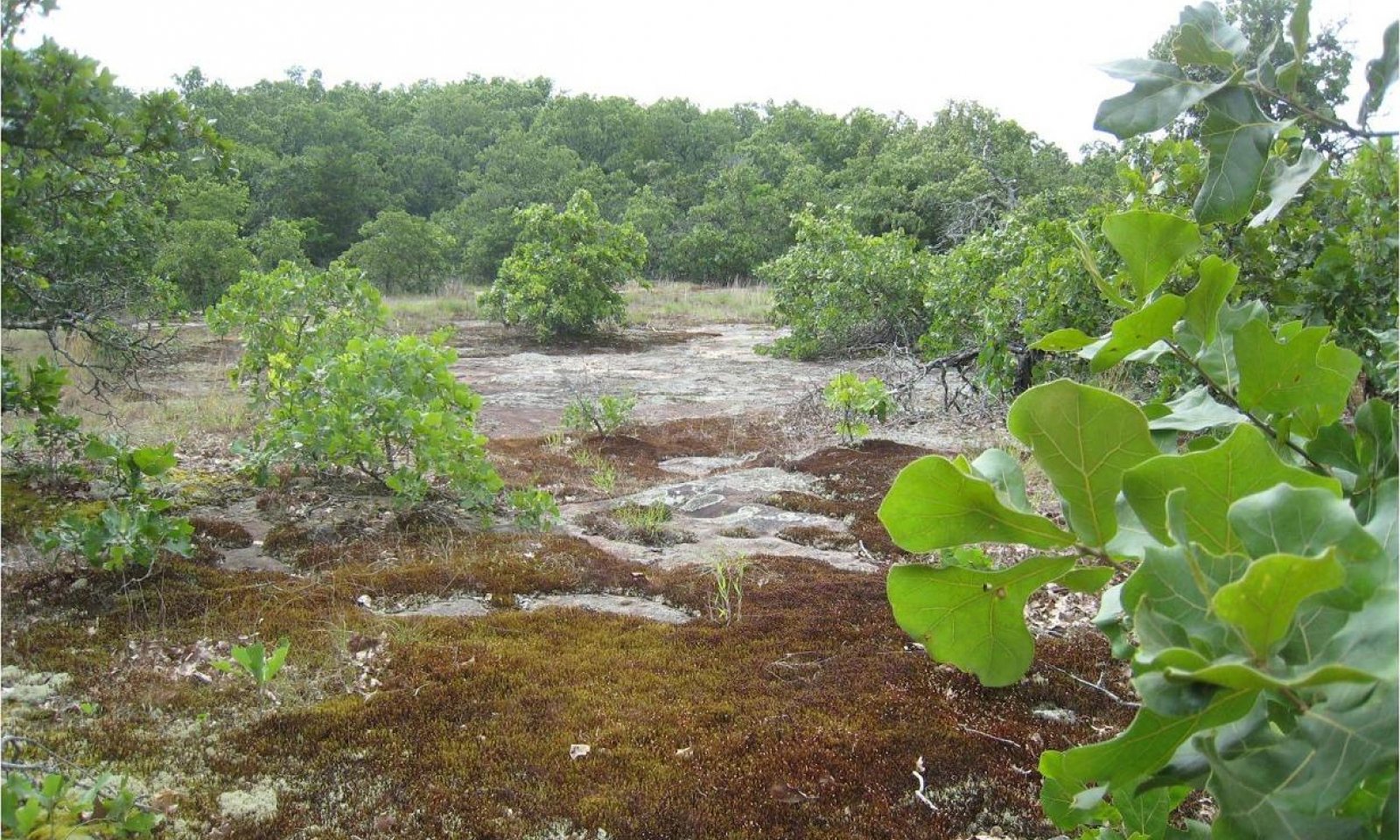
Figure 7. Bona Glad Natural Area, USACOE, Dade Co.
The interpretive plant community for the Shallow Sandstone Upland is a tallgrass plant community and represents the original plant composition that existed prior to European settlement. The site is characterized as a grassland with some trees and large shrubs, dominated by a mixture of four warm-season grasses. Big bluestem, switchgrass and Indiangrass are the major tallgrasses and little bluestem is the dominant midgrass. Combined, these four grasses will account for 70 to 80 percent of vegetation produced annually. Other prevalent midgrasses are marsh bristlegrass, plains muhly, purpletop tridens, sideoats grama, composite dropseed and purple lovegrass.
Intermittent seeps along steeper slopes may support additional tallgrasses such as eastern gamagrass, prairie cordgrass and Florida paspalum.
The site produces a wide variety of warm-season forb species that are interspersed throughout the grass sward. The most important include compassplant, wholeleaf rosinweed, Maximilian sunflower, stiff sunflower, pitcher sage and purple pale echinacea. Nuttall’s sensitive-briar, prairie bundleflower, slender lespedeza and violet prairie clover are the most abundant legumes.
Leadplant and Jersey tea are low-growing shrubs that occur throughout the site. In some locations prairie rose and scattered mottes of winged sumac and fragrant sumac may be present. Unlike most shrubs, these species are quite tolerant to fire. Roughleaf dogwood may occasionally be found growing in the shadow of rock outcrops on steeper slopes where it receives protection from fire. In some locations there may be a few plants of blackjack oak and post oak growing in protected areas.
Resilience management. This is a stable plant community when adequately managed. A prescribed grazing program that incorporates periods of deferment during the growing season benefits the tallgrasses and even the more palatable forb species. It is not uncommon for portions of this site to be partially avoided by livestock due to slope or the presence of surface rock.
Dominant plant species
-
little bluestem (Schizachyrium scoparium), grass
-
broomsedge bluestem (Andropogon virginicus), grass
-
Indiangrass (Sorghastrum nutans), grass
-
switchgrass (Panicum virgatum), grass
Community 1.2
Woody MidgrassThis plant community developed because of many years of continuous overgrazing. Midgrasses dominate the site and comprise 60 to 70 percent of annual production. The most abundant midgrasses include little bluestem, marsh bristlegrass, composite dropseed, sideoats grama, purpletop tridens, broomsedge bluestem, purple lovegrass and beaked panicum. Shortgrasses such as Carolina crabgrass, tumble windmill grass, hairy grama, buffalograss, Kentucky bluegrass and sedges produce 10 to 15 percent of the vegetation.
Remnant plants of big bluestem, Indiangrass and switchgrass, although sparse, are often found scattered throughout the site. In some locations they escape close grazing because of the protection of surface rock. In less-protected areas these plants are usually grazed repeatedly and remain in a low state of vigor. Of these remnants, big bluestem is generally the most abundant because of rhizomes that can persist for many years in a weakened condition. When in this state, new growth consisting of three to five leaves will emerge in a prostrate position rather than upright. This allows the plants to partially escape grazing by cattle. These remnants respond favorably to periods of rest from grazing and may regain vigor in two to three years.
Forb production is quite variable and may range from 10 to 30 percent of the total vegetation depending on amounts and timing of rainfall events. Perennial forbs include white heath aster, white sagebrush, Missouri goldenrod, ashy sunflower, tall eupatorium, Baldwin’s ironweed and Cuman ragweed. Annual forbs common on the site are prairie broomweed, annual ragweed, and prairie fleabane.
Most of the more-palatable shrubs such as leadplant, Jersey tea and prairie rose have disappeared. Other less-desirable shrubs such as coralberry, roughleaf dogwood, blackberry and smooth sumac have increased and may comprise 10 percent of the vegetation. Elm, common hackberry, blackjack oak, post oak, and eastern redcedar are the major trees found on the site.
Resilience management. Prescribed grazing with adequate rest and recovery periods during the growing season will shift this plant community to include more productive midgrasses. With continued management the taller grasses will gradually increase in abundance.
Dominant plant species
-
blackjack oak (Quercus marilandica), tree
-
post oak (Quercus stellata), tree
-
eastern redcedar (Juniperus virginiana), tree
-
smooth sumac (Rhus glabra), shrub
-
little bluestem (Schizachyrium scoparium), grass
Pathway 1.1A
Community 1.1 to 1.2Fire free interval of 5-10 years
Pathway 1.2A
Community 1.2 to 1.1Fire intervals 3-5 years.
State 2
Woody InvadedThis State is dominated by a shrub and/or tree plant community. The increase and spread of shrubs and trees resulted from an absence of fire and will be accelerated by seed introduction and/or spread. Woody plants can increase up to 34% from a lack of fire according to a study from 1937 to 1969, in contrast to a 1% increase on burned areas (Bragg and Hulbert, 1976). Periodic burning will hinder the establishment of most woody species and favor forbs and grasses. However, not all unburned areas have a woody plant invasion. Birds, small mammals, and livestock are instrumental in the distribution and spread of seed for most tree and shrub species common to this site. The speed of encroachment varies considerably and can occur on both grazed and non-grazed sites.
Characteristics and indicators. Hydrologic function in the Woody Invaded State is affected by the amount of shrub and/or tree cover compared to the Reference State. Canopy interception loss can vary from 25.4% to 36.7% (Thurow and Hester, 1997). A small rainfall event is usually retained in the foliage and does not reach the litter layer at the base of the tree. Only when canopy storage is reached and exceeded does precipitation fall to the soil surface. Interception losses associated with the accumulation of leaves, twigs, and branches at the bases of trees are considerably higher than losses associated with the canopy. The decomposed material retains approximately 40% of the water that is not retained in the canopy (Thurow and Hester, 1997). Soil properties affected include biological activity, infiltration rates, and soil fertility.
Dominant plant species
-
blackjack oak (Quercus marilandica), tree
-
post oak (Quercus stellata), tree
-
eastern redcedar (Juniperus virginiana), tree
-
smooth sumac (Rhus glabra), shrub
-
roughleaf dogwood (Cornus drummondii), shrub
-
little bluestem (Schizachyrium scoparium), grass
Community 2.1
Shrubs and/or TreesThis plant community is dominated by shrubs and trees. Roughleaf dogwood, coralberry, blackberry and winged sumac are generally the most abundant shrubs. Trees including elm, common hackberry, persimmon, Osage-orange and eastern redcedar have invaded and become well-established. In some locations blackjack oak and post oak have increased and form large colonies. Shrubs and trees may produce 30 to 60 percent of the total vegetation.
The spread of shrubs and trees results from an absence of fire because periodic burning tends to hinder the establishment of most of these woody species and favors forbs and grasses. However, not all unburned areas are invaded by woody plants. Birds, small mammals and livestock are instrumental in distributing seed and accelerating the spread of most shrubs common to this site. When both grazing and fire have been excluded for many years, associated grasses generally are big bluestem, little bluestem, Indiangrass, switchgrass, sedges and Canada wildrye.
Grass yields are significantly reduced because of the shrub and tree competition and vary from 30 to 50 percent of the total vegetative production. Forbs generally produce 10 to 20 percent of the total. Major forbs include white sagebrush, white heath aster, Cuman ragweed, Baldwin ironweed, and Canada goldenrod.Dominant plant species
-
blackjack oak (Quercus marilandica), tree
-
eastern redcedar (Juniperus virginiana), tree
-
winged sumac (Rhus copallinum), shrub
-
winged elm (Ulmus alata), shrub
-
little bluestem (Schizachyrium scoparium), grass
State 3
Degraded NativeThis State is a result of continuous overgrazing which allows broomsedge bluestem and other undesirable species to invade and become established. The cover, diversity and vigor of native species has decreased, and the ecological dynamics of these sites has changed. Potential physical site damage by continuous uncontrolled livestock grazing may further degrade this state.
Characteristics and indicators. This State is present when broomsedge bluestem becomes established and reaches 30-40% total production. These sites often have a significant present of woody species as well, especially eastern redcedar. Soil properties and chemistry of the site are often changed by the dominance of broomsedge, and this species can have allopathic effects on other native species. Fertilizer is commonly suggested to help increase production in other grasses. This will further change soil chemistry from its original state. This is partly why there is no known restoration pathway back to the Reference State.
Dominant plant species
-
eastern redcedar (Juniperus virginiana), tree
-
broomsedge bluestem (Andropogon virginicus), grass
Community 3.1
Broomsedge BluestemBroomsedge bluestem (Andropogon virginicus) is present at levels reaching 30-40% by weight on a per acre basis and is governing the ecological processes and potential uses of this community. Sites that are dominated by broomsedge often have altered soil properties and chemistry. Broomsedge can have allopathic effects on other native species. These sites may also have blackberry, purpletop tridens, various panicum, threeawn, and broomweed species present.
Dominant plant species
-
eastern redcedar (Juniperus virginiana), tree
-
broomsedge bluestem (Andropogon virginicus), grass
State 4
Invasive HerbaceousThe Invasive Herbaceous State is identified by a significant presence of non-native herbaceous plant species and is characterized by the composition of plant species and soil functions that govern the ecological processes.
Characteristics and indicators. Species that define this state include sericea lespedeza. Sericea lespedeza community phases are partially defined by the total production exceeding 15% by weight on a per acre basis. Ecological processes within this state that are affected and differ from the Reference State are hydrologic cycle and nutrient cycle. Water content and infiltration rates are also affected by the species in the plant community phase.
Resilience management. The Invasive Herbaceous State is sustained through continued reduction in health and vigor of native plant species and the increase in health and vigor, including seed production, of non-native herbaceous species. Ensuring a lack of forage quality due to season of grazing, and type of grazing animal, of the non-native plants will deter grazing of non-native plant species and increase grazing pressure on native plant species. A general lack of treatment measures for individual species control, maintenance, and/or eradication will also allow persistence of this state.
Dominant plant species
-
sericea lespedeza (Lespedeza cuneata), shrub
Community 4.1
Sericea LespedezaSericea lespedeza (Lespedeza cuneata) is present at levels exceeding 15% by weight on a per acre basis and governing the ecological processes and potential uses of this community. Sericea lespedeza is invasive and listed as a statewide noxious weed in Kansas. It competes with the native plant community for sunlight, water, and nutrients, and produces allelopathic compounds (toxic chemicals that negatively impact the germination and/or growth of other plants). It also contains tannins, that limit palatability, and produces copious amounts of seed that remain viable in the soil for decades. This species will quickly invade rangelands without proactive control measures.
Resilience management. Sericea lespedeza (<a class="species-link" href="https://plants.usda.gov/core/profile?symbol=LECU" target="_blank" title="Open in plants.usda.gov"><i>Lespedeza cuneata</i></a>) is extremely competitive with its allelopathic nature, lower palatability compared to native species, and good seedling vigor. To prevent further loss of native plant composition, ensure native plant vigor remains high via a forage-animal balance based on forage composition and palatability, utilize spot application of herbicides to control new and existing sericea lespedeza plants, and consider diversifying grazing livestock type. Control measures for sericea lespedeza involve herbicide application following extension recommendations and product label for proper rates and timing. Utilization and control can also be provided through sheep and goat grazing. Conventional management practices such as prescribed grazing with cattle and dormant-season fire have been less than effective in preventing the spread of sericea lespedeza in rangelands. Some suppression of sericea lespedeza has been observed after mowing or summer burning. Late summer fire significantly reduces seed production the year of burn. An integrated approach is needed when treating this species.
Dominant plant species
-
sericea lespedeza (Lespedeza cuneata), shrub
State 5
PasturelandThe Pastureland State is identified by a significant presence of non-native herbaceous plant species and is characterized by the composition of plant species, agronomic inputs from direct fertilization, and soil functions that govern the ecological processes. Sites consisting of introduced species and managed for their continued presence or spread should not be evaluated within this model and instead, consider using a separate land use model such as Pasture.
Characteristics and indicators. Tall fescue, smooth brome, and Kentucky bluegrass are partially defined by the total production exceeding 40% by weight on a per acre basis. Ecological processes within this state that are affected and differ from the Reference State are hydrologic cycle and nutrient cycle. Water content and infiltration rates are also affected by the species in the plant community phase.
Resilience management. Pastureland is sustained through continued reduction in health and vigor of native plant species and the increase in health and vigor, including seed production, of non-native herbaceous species. Agronomic inputs from direct fertilization or nutrient-rich runoff from adjacent crop fields will provide advantages for non-native cool-season grass species growth. Ensuring a lack of forage quality due to season of grazing, type of grazing animal, or chemical composition of the non-native plants will deter grazing of non-native plant species and increase grazing pressure on native plant species. A general lack of treatment measures for individual species control, maintenance, and/or eradication will also allow persistence of this state.
Dominant plant species
-
tall fescue (Schedonorus arundinaceus), grass
-
smooth brome (Bromus inermis), grass
-
Kentucky bluegrass (Poa pratensis), grass
Community 5.1
Fescue, Brome, BluegrassTall fescue, smooth brome, and Kentucky bluegrass (all being cool-season grasses) are present at levels exceeding 40% by weight on a per acre basis and are governing the ecological processes and potential uses of this community. Timing of plant growth has shifted from summer (May through August) and now mostly occurs in spring and fall (March to May and September to November). Fire intensity of late spring burns can be greatly impeded due to the significant quantity of cool-season grass present. Any one or a combination of these species can be considered an invaded community. Soil dynamic property changes include biological activity and soil fertility.
Resilience management. Tall fescue, smooth brome, and Kentucky bluegrass are sustained or increased with nutrient additions and absence of fire. To prevent further loss of native plant composition, avoid nutrient additions, ensure native plant vigor remains high via a forage-animal balance based on forage composition and seasonal availability, utilize herbicides when natives are dormant but cool-seasons are actively growing, and utilize consecutive late spring prescribed burns. Chemical control will involve herbicide application following extension recommendations and product label for proper rates and timing. Intensifying grazing pressure (leaf removal of cool-season grasses) during the spring and fall and removing grazing pressure during the summer will reduce cool-season grass vigor and allow native warm-season plants an opportunity to maximize growth and gain vigor. Prescribed burning will require sufficient standing dead material in order to conduct a burn in late spring as warm-season grasses initiate growth. If the goal is continued presence or spread of tall fescue, smooth brome, or Kentucky bluegrass, consider using a separate land use model such as Pasture.
Dominant plant species
-
tall fescue (Schedonorus arundinaceus), grass
-
smooth brome (Bromus inermis), grass
-
Kentucky bluegrass (Poa pratensis), grass
Transition T1A
State 1 to 2Fire suppression greater than 20 years.
Transition T1B
State 1 to 3Long term uncontrolled grazing will convert the Reference State to Degraded Native State
Transition T1C
State 1 to 4A transition from Reference to an Invasive Herbaceous State occurs when the site is invaded by Sericea lespedeza with the total production exceeding 15% by weight on a per acre basis.
Transition T1D
State 1 to 5Seeding of cool season grasses and forbs and proper pasture management will transition this Reference State to a Pastureland.
Restoration pathway R2A
State 2 to 1Cedar removal; prescribed fire.
Additional community tables
Table 5. Community 1.1 plant community composition
Group Common name Symbol Scientific name Annual production () Foliar cover (%) Table 6. Community 1.2 plant community composition
Group Common name Symbol Scientific name Annual production () Foliar cover (%) Table 7. Community 2.1 plant community composition
Group Common name Symbol Scientific name Annual production () Foliar cover (%) Table 8. Community 3.1 plant community composition
Group Common name Symbol Scientific name Annual production () Foliar cover (%) Table 9. Community 4.1 plant community composition
Group Common name Symbol Scientific name Annual production () Foliar cover (%) Table 10. Community 5.1 plant community composition
Group Common name Symbol Scientific name Annual production () Foliar cover (%) Interpretations
Supporting information
Inventory data references
Reference and alternative states within the state-and-transition model are not yet well- documented or supported and will require additional field sampling for refinement.
Other references
Missouri Department of Conservation. 2006. Missouri Forest and Woodland Community Profiles. Missouri Department of Conservation, Jefferson City, Missouri.
NatureServe. 2010. Vegetation Associations of Missouri (revised). NatureServe, St. Paul, Minnesota.
Nelson, Paul W. 2010. The Terrestrial Natural Communities of Missouri. Missouri Department of Conservation, Jefferson City, Missouri.
Nigh, Timothy A., & Walter A. Schroeder. 2002. Atlas of Missouri Ecoregions. Missouri Department of Conservation, Jefferson City, Missouri.
U.S. Dept. of Agric. Soil Conservation Service. 1977. Soil Survey of Vernon County, Missouri. Washington D.C.Contributors
Chris Tecklenburg, Hutchinson, KS
Doug Spencer, Salina KS
Doug Wallace, Missouri
Gene Campbell, SSOL, Clinton MOApproval
Suzanne Mayne-Kinney, 11/05/2024
Rangeland health reference sheet
Interpreting Indicators of Rangeland Health is a qualitative assessment protocol used to determine ecosystem condition based on benchmark characteristics described in the Reference Sheet. A suite of 17 (or more) indicators are typically considered in an assessment. The ecological site(s) representative of an assessment location must be known prior to applying the protocol and must be verified based on soils and climate. Current plant community cannot be used to identify the ecological site.
Author(s)/participant(s) Contact for lead author Date 09/14/2026 Approved by Approval date Composition (Indicators 10 and 12) based on Annual Production Indicators
-
Number and extent of rills:
-
Presence of water flow patterns:
-
Number and height of erosional pedestals or terracettes:
-
Bare ground from Ecological Site Description or other studies (rock, litter, lichen, moss, plant canopy are not bare ground):
-
Number of gullies and erosion associated with gullies:
-
Extent of wind scoured, blowouts and/or depositional areas:
-
Amount of litter movement (describe size and distance expected to travel):
-
Soil surface (top few mm) resistance to erosion (stability values are averages - most sites will show a range of values):
-
Soil surface structure and SOM content (include type of structure and A-horizon color and thickness):
-
Effect of community phase composition (relative proportion of different functional groups) and spatial distribution on infiltration and runoff:
-
Presence and thickness of compaction layer (usually none; describe soil profile features which may be mistaken for compaction on this site):
-
Functional/Structural Groups (list in order of descending dominance by above-ground annual-production or live foliar cover using symbols: >>, >, = to indicate much greater than, greater than, and equal to):
Dominant:
Sub-dominant:
Other:
Additional:
-
Amount of plant mortality and decadence (include which functional groups are expected to show mortality or decadence):
-
Average percent litter cover (%) and depth ( in):
-
Expected annual annual-production (this is TOTAL above-ground annual-production, not just forage annual-production):
-
Potential invasive (including noxious) species (native and non-native). List species which BOTH characterize degraded states and have the potential to become a dominant or co-dominant species on the ecological site if their future establishment and growth is not actively controlled by management interventions. Species that become dominant for only one to several years (e.g., short-term response to drought or wildfire) are not invasive plants. Note that unlike other indicators, we are describing what is NOT expected in the reference state for the ecological site:
-
Perennial plant reproductive capability:
Print Options
Sections
Font
AAAAOther
PrintThe Ecosystem Dynamics Interpretive Tool is an information system framework developed by the USDA-ARS Jornada Experimental Range, USDA Natural Resources Conservation Service, and New Mexico State University.
Accessibility statement


