Natural Resources
Conservation Service
Ecological site R080AY010OK
Claypan Upland (North)
Last updated: 9/19/2023
Accessed: 06/28/2026
-
Search


Major Land Resource Area or ecological site by name and/or ID.
PreviousSectionsNextGeneral information
Provisional. A provisional ecological site description has undergone quality control and quality assurance review. It contains a working state and transition model and enough information to identify the ecological site.
Click to explore map
Figure 1. Mapped extent
Areas shown in blue indicate the maximum mapped extent of this ecological site. Other ecological sites likely occur within the highlighted areas. It is also possible for this ecological site to occur outside of highlighted areas if detailed soil survey has not been completed or recently updated.
MLRA notes
Major Land Resource Area (MLRA): 080A–Central Rolling Red Prairies
MLRA 80A is characterized by dark red Permian sandstones or shales that are exposed on gently sloping plains. The dominant soil order in this MLRA is Mollisols. The soils in the area dominantly have a thermic soil temperature regime, an ustic soil moisture regime, and mixed, siliceous, or smectitic mineralogy. They generally are shallow to very deep, are well drained, and generally are loamy or clayey. These plains are dissected by rivers that flow from northwest to southeast. Major rivers of this MLRA include the Chickaskia and Bluff rivers in KS, the Salt Fork, Cimarron, North and South Canadian, Washita, Cache, Red River in OK, and branches of the Wichita River in TX.
Classification relationships
This ecological site is correlated to soil components at the Major Land Resource Area (MLRA) level which is further described in USDA Ag Handbook 296.
Ecological site concept
These sites occur on upland topography over deep soils weathered from shales or clays. The representative soils are mollisols, however, this site differs from the Loamy Upland site due to the dense clay subsoils (Claypan) that can limit plant available water and lead to lower productivity. The reference grassland state is a mixture of tallgrasses, midgrasses, forbs , and occasional shrubs.
Associated sites
R080AY056OK Loamy Upland
Adjacent upland site. Loamy surface, lacks abrupt textural change.
Similar sites
R080AY011OK Claypan Upland (South)
R080AY011OK lays south of R080AY010OK beginning at Interstate 40. The sites are very similar for several miles north and south of the interstate.
R080AY056OK Loamy Upland
Adjacent upland site. Loamy surface, lacks abrupt textural change.
Table 1. Dominant plant species
Tree Not specified
Shrub (1) Amorpha canescens
Herbaceous (1) Schizachyrium scoparium
(2) Silphium laciniatumPhysiographic features
This site is an upland site on hills and paleoterraces. Slopes vary from 1 to 5 percent. The site may receive some run-on water from uphill sites and also shed water via run-off to sites downslope.

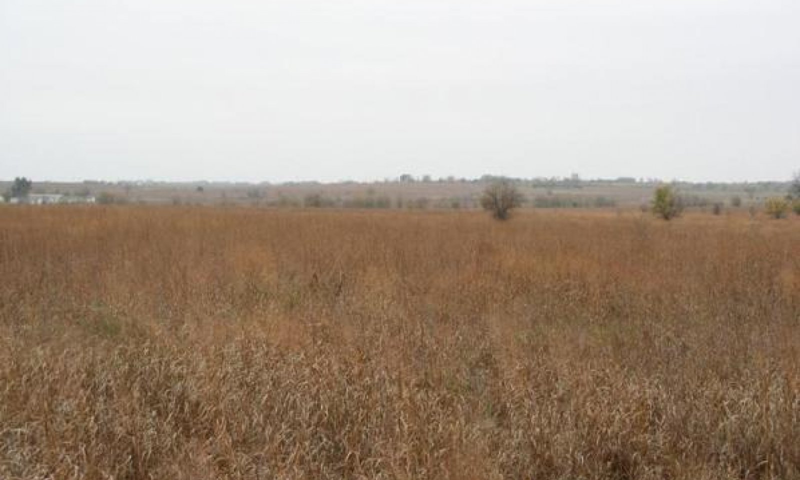
Figure 2. Claypan Prairie
Table 2. Representative physiographic features
Landforms (1) Plains > Hill
(2) Plains > Paleoterrace
Runoff class High to very high Flooding frequency None Ponding frequency None Elevation 700 – 1500 ft Slope 1 – 5 % Ponding depth 0 in Water table depth 80 – 0 in Aspect Aspect is not a significant factor Climatic features
The climate is characterized by moist, cool, springs; hot, often dry summers; mild autumns; and mild to cold winters. Variation in timing and amounts of precipition from year to year is quite common. Drought cycles range from three to five years duration with occasionally longer periods occurring at unpredictable intervals. Above normal rainfall cycles are usually just as random, but shorter in duration.
Table 3 Representative climatic features
Frost-free period (characteristic range) 180-190 days Freeze-free period (characteristic range) 200-220 days Precipitation total (characteristic range) 30-40 in Frost-free period (actual range) 170-190 days Freeze-free period (actual range) 200-230 days Precipitation total (actual range) 30-40 in Frost-free period (average) 190 days Freeze-free period (average) 210 days Precipitation total (average) 40 in Characteristic rangeActual rangeBarLineFigure 3. Monthly precipitation range
Characteristic rangeActual rangeBarLineFigure 4. Monthly minimum temperature range
Characteristic rangeActual rangeBarLineFigure 5. Monthly maximum temperature range
BarLineFigure 6. Monthly average minimum and maximum temperature
Figure 7. Annual precipitation pattern
Figure 8 Annual average temperature pattern
Climate stations used
-
(1) CUSHING [USC00342318], Cushing, OK
-
(2) GEARY [USC00343497], Calumet, OK
-
(3) MEEKER 5 W [USC00345779], Meeker, OK
-
(4) NORMAN 3SSE [USC00346386], Norman, OK
-
(5) OKEENE [USC00346629], Okeene, OK
-
(6) PONCA CITY MUNI AP [USW00013969], Ponca City, OK
-
(7) CHEROKEE 4W [USC00341724], Cherokee, OK
-
(8) CHICKASHA EXP STATION [USC00341750], Chickasha, OK
-
(9) ANTHONY [USW00013980], Anthony, KS
">Influencing water features
This site's dense clayey subsoils slow moisture infiltration. Surface soils may become saturated and remain extremely wet for extended periods of time following heavy rainfall events. Subsoils have the ability to store water, but this water is tightly held by clay particles, so, during periods of below normal precipitation, plants stress quickly.
Wetland description
NA

Figure 9.
Soil features
Soils are mapped for each county within the MLRA. Mapunits are representations of the major soil series component(s) and named accordingly. Each Mapunit is spatially represented on a digital soils map as polygons of different shapes and sizes. Within these Mapunits, there are often minor soil series components included. These minor components are soils that occur within a Mapunit polygon but are of small extent (15% or less of the Mapunit area). However, it is difficult to separate these minor soils spatially due to the scale of soil mapping.
Ecological sites are correlated at the component level of the soil survey. Therefore, a single Mapunit may contain multiple Ecological Sites just as it may contain multiple soil components. This is important to understand when investigating soils and Ecological Sites. A soil survey Mapunit may be correlated to a single Ecological Site based on the major component; however, there may be inclusional areas of additional Ecological Sites which are correlated to the minor components of that particular soil Mapunit.
Representative soil components for this site include:
Agra, Kirkland, & Renfrow
These are silt loam to clay loam surface textured soils, eight to twelve inches deep, with compact blocky clay subsoils.Table 4. Representative soil features
Parent material (1) Residuum – clayey shale
Surface texture (1) Silt loam
(2) Clay loam
(3) Silty clay loam
Drainage class Moderately well drained to well drained Permeability class Very slow to slow Soil depth 26 – 99 in Surface fragment cover <=3" 0 – 2 % Surface fragment cover >3" 0 – 2 % Available water capacity
(0-40in)2 – 8 in Calcium carbonate equivalent
(0-40in)0 – 2 % Electrical conductivity
(0-40in)0 – 2 mmhos/cm Sodium adsorption ratio
(0-40in)0 – 2 Soil reaction (1:1 water)
(0-40in)5.6 – 8.4 Subsurface fragment volume <=3"
(Depth not specified)0 – 44 % Subsurface fragment volume >3"
(Depth not specified)0 – 30 % Table 5. Representative soil features (actual values)
Drainage class Not specified Permeability class Not specified Soil depth 0 in Surface fragment cover <=3" 0 % Surface fragment cover >3" 0 % Available water capacity
(0-40in)0 in Calcium carbonate equivalent
(0-40in)0 – 5 % Electrical conductivity
(0-40in)0 – 4 mmhos/cm Sodium adsorption ratio
(0-40in)0 – 12 Soil reaction (1:1 water)
(0-40in)0 Subsurface fragment volume <=3"
(Depth not specified)0 % Subsurface fragment volume >3"
(Depth not specified)0 % Ecological dynamics
Like many sites across the Great Plains, this Claypan Upland site evolved under periodic disturbances by fire, drought, and grazing (Frost 1998, Fuhlendorf 2009). The soils are well suited for herbaceous plant growth but are somewhat limited by their dense clay subsoil. The potential of the clay subsoil to restrict plant available water makes the site more susceptible to influence by drought the the loamy upland sites. However, the reference state of this site is very resilient to natural disturbances. Alternative land uses include cropland and pastureland. Alternative states within the rangeland land use include a woody encroached state, a reseeded state and an eroded state.
The reference state for this site is dominated by warm-season perennial grasses. The composition consists of fluctuating tallgrasses and midgrasses interspersed with numerous perennial warm-season forbs. A small component of cool-season grasses and forbs occurs on this site. The dominant grasses and forbs have evolved under extreme conditions of excessive moisture and extended drought. Grazing by large herbivores and fire were both common during the development of this reference state.
The soils typically have dense clayey subsoils that greatly influence plant growth. Clayey subsoils slow moisture infiltration. Surface soils may become saturated and remain extremely wet for extended periods of time following heavy rainfall events. Subsoils may store large amounts of water, but usually this moisture is tightly held (bonded) so, during periods of below normal precipitation, plants stress quickly.
The absence of fire or alternative brush management can lead to the increase of woody species on the site. The woody species begin to dominate ecological processes (hydrology, energy flow, etc.) and transition the site to the woody state (Scholtz, 2018).
Historically, the focus of conservation efforts has been on proper stocking rates and restoration of the woody encroached sites across the Great Plains. However, new research suggests that a more effective strategy involves addressing woody plants in the seed dispersal stage prior to the change in ecological states. Preserving intact prairie for both agricultural production and ecosystem services must become a priority for land managers and conservationist alike.
Additionally, the site is well suited for crop production and a large portion of the site remains in the cultivated state of the cropland land use.
This site has the potential to be converted to a variety of introduced monocultures. This requires cultivation, seeding or sprigging, and fertilization. There are eroded soils mapped in Claypan Upland ESD, so an eroded state has been added to the State and Transition Model. This state is usually a result of cultivation and water erosion.
State and Transition Diagram:
A State and Transition Diagram for the Claypan Upland (R080AY010OK) is depicted below. Descriptions of each state, transition, and pathway follow the model. Experts based this model on available experimental research, field observations, professional consensus, and interpretations. It is likely to change as knowledge increases.
Plant communities will differ across the MLRA because of the natural variability in weather, soils, and aspect. The Reference Plant Community is not necessarily the management goal; other vegetative states may be desired plant communities as long as the Range Health assessments are in the moderate and above category.
The biological processes on this site are complex. Therefore, representative values are presented in a land management context. The species lists are representative and are not botanical descriptions of all species occurring, or potentially occurring, on this site. They are not intended to cover every situation or the full range of conditions, species, and responses for the site.State and transition model
More interactive model formats are also available. View Interactive Models
Click on state and transition labels to scroll to the respective textLand use 1 submodel, ecosystem states
State 1 submodel, plant communities
State 2 submodel, plant communities
State 3 submodel, plant communities
Land use 2 submodel, ecosystem states
Land use 3 submodel, ecosystem states
Land use 1
RangelandThis land use is predominately used for grazingland or recreational use. This land use often requires fewer or less intensive inputs than other land use types. The rangeland land use includes both reference, unplowed rangeland as well as land that has been reseeded or repopulated to native species post-cultivation.
State 1.1
Grassland (Reference)This is the reference or diagnostic community for the site. The description is based on early range site descriptions, clipping data, professional consensus of experienced range specialists, and analysis of field work.
Dominant plant species
-
leadplant (Amorpha canescens), shrub
-
little bluestem (Schizachyrium scoparium), grass
State 1.2
WoodyIn the woody state of this ecological site, trees and/or shrub species have increased to >30% cover. This is most often caused by lack of fire and facilitated by continued overgrazing beyond carrying capacity for the site. Grazing resources are compromised in this state as well as the health and vigor of the grassland plant community. Brush species may include native trees and shrubs such as Sumac, Roughleaf Dogwood, sand Plum, or Eastern Redcedar.
Dominant plant species
-
eastern redcedar (Juniperus virginiana), tree
-
sumac (Rhus), shrub
State 1.3
ReseededThis state represents the land use change back to rangeland after a period of cultivation. The site can be reseeded to native species or left to naturally revegetate (go-back). While many species of the reference state may be present, soil structure, biology, and chemistry have been significantly altered through cultivation. It may take many years to recover to something similar to reference conditions.
Dominant plant species
-
little bluestem (Schizachyrium scoparium), grass
State 1.4
ErodedThis state is the result of water erosion over bare soil as a result of cultivation. Most of the "A" horizon of the soil profile has been displaced. The remaining subsoil is very low in fertility. Some native grasses and forbs will persist in this state, however, production is greatly reduced.
Resilience management. With time, eroded sites may revegetate or be reseeded with native species. While the plant communities can resemble the reference state, the soil physical, chemical, and biological properties may take many years to recover.
Dominant plant species
-
silver beardgrass (Bothriochloa laguroides), grass
-
threeawn (Aristida), grass
Transition T1A
State 1.1 to 1.2If heavy grazing that exceeds the carrying capacity continues without some type of brush managment measures, there will likely be an increase in the woody component of the plant community. Without the fine fuels, prescribed fire is not very effective at controling the woody encroachment and thus, is seldom attempted. The community will transition to a state of woody dominance(2).
Transition T1B
State 1.1 to 1.3This transition involves the land use change to cropland or introduced pastureland and then returning to rangeland use. The site has been cultivated for a period of time and returned to perennial vegetation.
Constraints to recovery.While the return of perennial vegetation can stabilize the soil and begin to improve structure and biological processes, the site may not recover to reference soil conditions for a very long time.
Restoration pathway R2A
State 1.2 to 1.1Through a conservation system of brush management, prescribed grazing(deferment), and prescribed the burning, the woody state may be restored to a plant community within the Grassland(Reference) State.
Transition T3A
State 1.3 to 1.2If land is abandonded once in the converted state, it may be very easy for woody species to dominate the plant community if no prescribed fire program is implemented.
Land use 2
CroplandThe site has been cultivated for the production of crops. Primary use is agronomic crop production.
State 2.1
Conventional TillageThis community represent a conventional tillage system where subsequent crops are planted into a clean tilled seedbed. Crop rotations may also be used in this production system, however, the field are consistently plowed between plantings. Perennial cultivation can lead to accelerated soil loss from water and wind erosion. Proper planning is essential to ensure soil and water conservation in this system.
Characteristics and indicators. The soil is disturbed through plowing or discing the soil multiple times a year.
Resilience management. This management system is at great risk of soil erosion through water and or wind. Soil structure and biology are also at risk of degradation through this style of management.
Dominant plant species
-
wheat (Triticum), grass
-
soybean (Glycine max), other herbaceous
State 2.2
No-Till
This community represents a no-till management system where subsequent crops are planted directly through residue remaining in the field. Crop rotations are often used in this system and, over time, this system may result in increased soil aggregation and increase organic matter. A no-till system may also help mitigate soil erosion.
Characteristics and indicators. This system includes minimal soil disturbance and the use of No-Till planting methods. Residue is left in the field after harvest.
Resilience management. With this management system, soil biology and structure may begin to recover. Erosion risk is much lower than the conventional tillage system.
Dominant plant species
-
wheat (Triticum), grass
-
soybean (Glycine max), other herbaceous
Dominant resource concerns
-
Sheet and rill erosion
-
Wind erosion
-
Ephemeral gully erosion
Transition T
State 2.1 to 2.2Restoration pathway R
State 2.2 to 2.1Land use 3
Introduced PasturelandThe site has been replanted to introduced forage grasses after cultivation ceased. Primary use is livestock and/or hay production. Often, this land use is managed as a monoculture with little biotic diversity. However, in some cases, forb/legume/grass mixtures are maintained with may increase soil and ecosystem health.
State 3.1
Monoculture
This community consists of a planted monoculture of an introduced pasture grass used predominately for grazing and/or hay production. Adapted species include bermudagrass, old world bluestems, and weeping lovegrass (only on well drained sites). These species require a higher level of management inputs than native rangeland species. Soil tests should be performed prior to planting and or subsequent fertilizer applications. Without persistent nutrient management and proper grazing, some undesired "weedy" species may invade the site. While biodiversity can be beneficial to both plants, animals, and soil, it may be undesirable under certain management systems such as certified hay production. Proper grazing should be planned to allow for adequate residual heights in order to ensure the vigor of the grass. These heights vary by species and grazing system. They can be found in the OK NRCS Prescribed Grazing practice specification. Average yields are listed below as representative for the MLRA. These yields can vary greatly depending on precipitation amount and timing. As with any pasture management program, site specific evaluation and monitoring is essential.
Yields are represented AUMs or Animal Unit Months. This represents the amount of dry matter required by one Animal Unit Equivalent for one month. For more on AUEs and AUMs consult local extension service fact sheets and publications. Keep in mind these yields are estimated under a high level of management which includes annual additions of nitrogen and other nutrients as required.
It is important to note that while these introduced species can provide good grazing potential, often wildlife habitat is limited. These species are also known to expand offsite and become invasive in adjacent native ecosystems.Dominant plant species
-
Bermudagrass (Cynodon dactylon), grass
State 3.2
Grass/Legume Mix
This community represents a planted mixture of introduced grasses and forbs/legumes. Bermudagrass and introduced clover is the most common pasture mix. Incorporation of a legume into the system can help offset inputs associated with nitrogen additions. Special strategies should be used to ensure the health and vigor of both the cool season legumes and warm season grasses. Yields for these pasture mixes are not available as the mixtures and ratios vary from site to site so yields for a monoculture community should be used as a baseline estimate.
Dominant plant species
-
Bermudagrass (Cynodon dactylon), grass
-
clover (Trifolium), other herbaceous
Conversion C1
Land use 1 to 2Through cultivation and seeding of crop species, this land use is converted to Cropland.
Conversion C4
Land use 2 to 1This land use conversion is achieved through reseeding native grasses and forbs in order to restore the site for livestock grazing or hay production. While the site may be converted back to a rangeland land use, some soil properties and ecological function may not return to pre-cultivation levels.
Conversion C2
Land use 2 to 3With the cessation of cultivation and planting of perennial introduced forage grasses, this land use is converted to Introduced Pastureland.
Conversion C3
Land use 3 to 1This land use conversion is achieved through reseeding native grasses and forbs or allowing native species to repopulate the site by reducing management of introduced species. While the site may be converted back to a rangeland land use, some soil properties and ecological function may not return to pre-cultivation levels.
Additional community tables
Table 6. Community 1.1 plant community composition
Group Common name Symbol Scientific name Annual production () Foliar cover (%) Grass/Grasslike1 1196–2060 big bluestem ANGE Andropogon gerardii 814–1400 – switchgrass PAVI2 Panicum virgatum 240–416 – Indiangrass SORGH Sorghastrum 116–208 – eastern gamagrass TRDA3 Tripsacum dactyloides 36–64 – 2 840–1456 little bluestem SCSC Schizachyrium scoparium 1050–1820 – 3 420–720 dropseed SPORO Sporobolus 157–270 – sideoats grama BOCU Bouteloua curtipendula 87–150 – blue grama BOGR2 Bouteloua gracilis 58–100 – thin paspalum PASE5 Paspalum setaceum 58–100 – marsh bristlegrass SEPA10 Setaria parviflora 28–50 – Florida paspalum PAFL4 Paspalum floridanum 28–50 – silver bluestem BOSA Bothriochloa saccharoides 28–50 – fall witchgrass DICO6 Digitaria cognata 23–40 – purple lovegrass ERSP Eragrostis spectabilis 23–40 – white tridens TRAL2 Tridens albescens 18–30 – purpletop tridens TRFL2 Tridens flavus 18–30 – 4 180–312 Canada wildrye ELCA4 Elymus canadensis 117–200 – Virginia wildrye ELVI3 Elymus virginicus 58–100 – western wheatgrass PASM Pascopyrum smithii 58–100 – sedge CAREX Carex 46–80 – Scribner's rosette grass DIOLS Dichanthelium oligosanthes var. scribnerianum 41–70 – winter bentgrass AGHY Agrostis hyemalis 23–40 – prairie Junegrass KOMA Koeleria macrantha 12–20 – prairie wedgescale SPOB Sphenopholis obtusata 12–20 – Forb5 114–208 compassplant SILA3 Silphium laciniatum 87–150 – Maximilian sunflower HEMA2 Helianthus maximiliani 87–150 – white heath aster SYER Symphyotrichum ericoides 41–70 – greenthread THELE Thelesperma 29–50 – ashy sunflower HEMO2 Helianthus mollis 29–50 – dotted blazing star LIPU Liatris punctata 29–50 – whitest evening primrose OEAL Oenothera albicaulis 29–50 – cobaea beardtongue PECO4 Penstemon cobaea 29–50 – upright prairie coneflower RACO3 Ratibida columnifera 29–50 – Cuman ragweed AMPS Ambrosia psilostachya 29–50 – false boneset BREU Brickellia eupatorioides 29–50 – pale purple coneflower ECPA Echinacea pallida 29–50 – prairie fleabane ERST3 Erigeron strigosus 29–50 – scarlet beeblossom GACO5 Gaura coccinea 25–50 – Canada goldenrod SOCA6 Solidago canadensis 29–50 – Missouri goldenrod SOMI2 Solidago missouriensis 29–50 – azure blue sage SAAZ Salvia azurea 29–50 – white sagebrush ARLU Artemisia ludoviciana 23–40 – Texas goldentop EUGY Euthamia gymnospermoides 18–30 – fringeleaf wild petunia RUHU Ruellia humilis 18–30 – prairie spiderwort TROC Tradescantia occidentalis 18–30 – hoary verbena VEST Verbena stricta 12–20 – stiffstem flax LIRI Linum rigidum 12–20 – Carolina larkspur DECA3 Delphinium carolinianum 12–20 – rainlily COOPE Cooperia 6–10 – 6 88–156 Illinois bundleflower DEIL Desmanthus illinoensis 41–70 – littleleaf sensitive-briar MIMI22 Mimosa microphylla 41–70 – slimflower scurfpea PSTE5 Psoralidium tenuiflorum 29–50 – lespedeza LESPE Lespedeza 29–50 – groundplum milkvetch ASCR2 Astragalus crassicarpus 18–30 – smallflowered milkvetch ASNU4 Astragalus nuttallianus 18–30 – white prairie clover DACA7 Dalea candida 18–30 – prairie clover DALEA Dalea 18–30 – Shrub/Vine7 0–52 leadplant AMCA6 Amorpha canescens 0–52 – ceanothus CEANO Ceanothus 0–52 – smooth sumac RHGL Rhus glabra 0–52 – coralberry SYOR Symphoricarpos orbiculatus 0–52 – Table 7. Community 1.2 plant community composition
Group Common name Symbol Scientific name Annual production () Foliar cover (%) Table 8. Community 1.3 plant community composition
Group Common name Symbol Scientific name Annual production () Foliar cover (%) Table 9. Community 5.1 plant community composition
Group Common name Symbol Scientific name Annual production () Foliar cover (%) Table 10. Community 7.1 plant community composition
Group Common name Symbol Scientific name Annual production () Foliar cover (%) Interpretations
Animal community
This site is suited for grazing cattle. Quail utilize the site for food, nesting, and occasional cover. Coyote, badger, skunk, cottontail rabbit and ground squirrels are common. There is some site use by whitetail deer. Hawks, including the red-tailed hawk, Coopers’ hawk, Rough-legged hawk, sparrow hawk and marsh hawk utilize this site for hunting prey.
Hydrological functions
These upland site may shed some water via runoff during heavy rain events. The presence of good ground cover and deep rooted grasses can help facilitate infiltration and reduce sediment loss. As residue height decreases, run off during storm events may increase.
Recreational uses
N/A
Wood products
N/A
Other products
N/A
Other information
N/A
Supporting information
Inventory data references
Information presented has been derived from NRCS clipping data, research from Oklahoma State University, field observations and measurements by trained range personnel. Most of the clipping data was gathered by a team consisting of a range conservationist and a soil scientist and was site/soil specific. Yields were taken at the end of the growing season and, as near as possible, were obtained from areas that were un-grazed that year. Clipping data repository is in the NRCS State Office in Stillwater, OK. Data from NRI collections and field sampling was also used in the development of this ESD.
Type locality
Location 1: Payne County, OK Township/Range/Section T18N R1E SNW3 General legal description OSU CTER NW3-T18N-R1E References
-
. 2021 (Date accessed). USDA PLANTS Database. http://plants.usda.gov.
-
Frost, C.C. 1998. Presettlement Fire Frequency Regimes of the United States: A First Approximation. Plant Conservation Program. North Carolina Department of Agriculture and Consumer Services, Raleigh, NC.
-
Fuhlendorf, S.D., D.M. Engle, J. Kerby, and R. Hamilton. 2009. Pyric Herbivory: Rewilding Landscapes through the Recoupling of Fire and Grazing. Conservation Biology 23:588–598.
-
Scholtz, R. and . 2018. Grassland fragmentation and its influence on woody plant cover in the southern Great Plains, USA. Landscape Ecology 33:1785–1797.
Other references
Bestelmeyer, B. T., Brown, J. R., Havstad, K. M., Alexander, R., Chavez, G., & Herrick, J. E. (2003). Development and use of state-and-transition models for rangelands. Journal of Range Management, 114-126.
Frost, Cecil C. 1998. Presettlement fire frequency regimes of the United States: a first approximation. Pages 70-81.Tall Timbers Fire Ecology Conference Proceedings, No. 20. Tall
Timbers Research Station, Tallahassee, FL.
Fuhlendorf, S. D., Engle, D. M., Kerby, J. A. Y., & Hamilton, R. (2009). Pyric herbivory: rewilding landscapes through the recoupling of fire and grazing. Conservation Biology, 23(3), 588-598.
Harlan, J. R. (1957). Grasslands of Oklahoma.
National Soil Information System (NASIS). Accessed 2013
Shantz, H. L. (1923). The natural vegetation of the Great Plains region. Annals of the Association of American Geographers, 13(2), 81-107.
Shiflet, T. N. (1994). Rangeland cover types of the United States (Vol. 152). Denver, CO, USA: Society for Range Management.Contributors
Dr. Jack Eckroat, Grazing Lands Specialist, NRCS, Oklahoma
Harland DietzApproval
Bryan Christensen, 9/19/2023
Acknowledgments
Site Development and Testing Plan: Future work, as described in a Project Plan, to validate the information in this Provisional Ecological Site Description is needed. This will include field activities to collect low, medium and high intensity sampling, soil correlations, and analysis of that data. Annual field reviews should be done by soil scientists and vegetation specialists. A final field review, peer review, quality control, and quality assurance reviews of the ESD will be needed to produce the final document. Annual reviews of the Project Plan are to be conducted by the Ecological Site Technical Team.
Rangeland health reference sheet
Interpreting Indicators of Rangeland Health is a qualitative assessment protocol used to determine ecosystem condition based on benchmark characteristics described in the Reference Sheet. A suite of 17 (or more) indicators are typically considered in an assessment. The ecological site(s) representative of an assessment location must be known prior to applying the protocol and must be verified based on soils and climate. Current plant community cannot be used to identify the ecological site.
Author(s)/participant(s) Mark Moseley, Harry Fritzler, Steve Glasgow, Jack Eckroat Contact for lead author 100 USDA Suite 206 Stillwater, OK 74074 Date 04/01/2005 Approved by Approval date Composition (Indicators 10 and 12) based on Annual Production Indicators
-
Number and extent of rills:
There are few, if any, rills and there is no active headcutting and sides are covered with vegetation. -
Presence of water flow patterns:
There is some evidence of soil deposition or erosion, particularly after significant rain events, but water generally flows evenly over the entire landscape. -
Number and height of erosional pedestals or terracettes:
There should not be any evidence of erosional pedestals or terracettes on this site. -
Bare ground from Ecological Site Description or other studies (rock, litter, lichen, moss, plant canopy are not bare ground):
There is ~5% bare ground on this site. Bare areas are small and not connected. -
Number of gullies and erosion associated with gullies:
None, drainages are represented as natural stable channels; vegetation is common with no signs of erosion. -
Extent of wind scoured, blowouts and/or depositional areas:
None. -
Amount of litter movement (describe size and distance expected to travel):
Uniform distribution of litter. Litter rarely moves >6 inches on flatter slopes and may be as much as doubled on steeper slopes, then only during high intensity storms. -
Soil surface (top few mm) resistance to erosion (stability values are averages - most sites will show a range of values):
Surface soil is stabilized (Stability Score 5 – 6). Stability scores based on a minimum of 6 samples tested. -
Soil surface structure and SOM content (include type of structure and A-horizon color and thickness):
A horizon: 0 to 13 inches; silt loam, clay loam, medium granular structure. Btssl horizon: 13 to 25 inches; reddish brown clay, moderate medium blocky structure. Refer to specific description for component sampled. -
Effect of community phase composition (relative proportion of different functional groups) and spatial distribution on infiltration and runoff:
Infiltration and runoff are not affected by any changes in plant community composition and distribution. (Tallgrass dominated). Any changes in infiltration and runoff can be attributed to other factors (e.g. compaction). -
Presence and thickness of compaction layer (usually none; describe soil profile features which may be mistaken for compaction on this site):
There is usually no compaction layer. Naturally dense subsoil may be mistaken for a compaction layer. -
Functional/Structural Groups (list in order of descending dominance by above-ground annual-production or live foliar cover using symbols: >>, >, = to indicate much greater than, greater than, and equal to):
Dominant:
TallgrassesSub-dominant:
Midgrasses, ShortgrassesOther:
Forbs, Cool-Season Perennial Grasses, ShrubsAdditional:
-
Amount of plant mortality and decadence (include which functional groups are expected to show mortality or decadence):
There is some plant mortality and decadence on the perennial grasses, especially in the absence of fire and herbivory, but usually <5%. -
Average percent litter cover (%) and depth ( in):
Litter should cover 50-75% of the area between plants with accumulations of .25-1 inch deep. -
Expected annual annual-production (this is TOTAL above-ground annual-production, not just forage annual-production):
Normal production is 2838-4964 pounds per acre. -
Potential invasive (including noxious) species (native and non-native). List species which BOTH characterize degraded states and have the potential to become a dominant or co-dominant species on the ecological site if their future establishment and growth is not actively controlled by management interventions. Species that become dominant for only one to several years (e.g., short-term response to drought or wildfire) are not invasive plants. Note that unlike other indicators, we are describing what is NOT expected in the reference state for the ecological site:
No invasive species. Invasives might include: eastern redcedar, bois d’arc, mesquite, annuals and non-natives. -
Perennial plant reproductive capability:
All plants capable of reproducing at least every 2 years. Seed stalks, stalk length, and seedheads are numerous and what would be expected. Overall health of plants is what would be expected.
Print Options
Sections
Font
AAAAOther
PrintThe Ecosystem Dynamics Interpretive Tool is an information system framework developed by the USDA-ARS Jornada Experimental Range, USDA Natural Resources Conservation Service, and New Mexico State University.
Accessibility statement