
Natural Resources
Conservation Service
-
Search


Major Land Resource Area or ecological site by name and/or ID.
PreviousSectionsNextGeneral information
Provisional. A provisional ecological site description has undergone quality control and quality assurance review. It contains a working state and transition model and enough information to identify the ecological site.
Click to explore map
Figure 1. Mapped extent
Areas shown in blue indicate the maximum mapped extent of this ecological site. Other ecological sites likely occur within the highlighted areas. It is also possible for this ecological site to occur outside of highlighted areas if detailed soil survey has not been completed or recently updated.
MLRA notes
Major Land Resource Area (MLRA): 078C–Central Rolling Red Plains, Eastern Part
MLRA 78C is characterized by moderately dissected, rolling plains with prominent ridges and valleys and numerous terraces adjacent to dissecting streams. Loamy and clayey soils are generally deep, well drained, and developed in calcareous and gypsiferous sediments of Permian age.
LRU notes
NA
Classification relationships
This ecological site is correlated to soil components at the Major Land Resource Area (MLRA) level which is further described in USDA Ag Handbook 296.
Ecological site concept
The Loamy Upland ecological site is one of the most extensive sites within the MLRA. The reference plant community for this site has evolved through historical fires and periodic grazing events. The reference community consist of native tallgrasses and forbs with a small amount of woody shrubs. If fire is removed from the system, wood species may encroach and eventually dominate the ecosystem processes. Eastern redcedar is one of the woody species that has invaded many of the Loamy Prairie ecosites over the last century.
Associated sites
R078CY083OK Shallow Upland
In MLRA 78C, Shallow Prairie ecological sites may be right next to Loamy Prairie sites. Sometimes, it's hard to tell where one begins and the other ends.
R078CY005OK Loamy Breaks
Similar soils >20% slopes. Less productivity.
Similar sites
R078BY081TX Loamy Upland 19-26" PZ
Loamy Upland site in 78B
Table 1. Dominant plant species
Tree Not specified
Shrub (1) Amorpha canescens
Herbaceous (1) Andropogon gerardii
Physiographic features
This site is productive upland with deep, well drained, loamy soils formed from alluvial deposits or weathered sandstone. Slopes are nearly level to steeply rolling.

Figure 2. Loamy Prairie
Table 2. Representative physiographic features
Landforms (1) Plains > Terrace
(2) Plains > Stream terrace
(3) Plains > Plain
Runoff class Low to high Flooding frequency None Ponding frequency None Elevation 1000 – 2500 ft Slope 0 – 12 % Ponding depth 0 in Water table depth 72 – 80 in Aspect Aspect is not a significant factor Climatic features
MLRA 78C lies within the subtropical sub-humid climate regime. This regime is characterized by rapid changes in temperature; marked extremes, both daily and annual; and rather erratic rainfall. The weather is alternately influenced by cold dry air from the Arctic Circle, and warm moist air from the Gulf of Mexico.
Seasonal changes are gradual. Spring is a season of variable weather and relatively high precipitation with prevailing winds from the southwest. Summers are generally hot with low humidity. Fall has long periods of pleasant weather interspersed with moderate to heavy rains. Winter is open and moderate to cold with winds from the north and infrequent snows.
Wind speeds average more than eleven miles an hour with prevailing southern winds. Rather strong winds can occur in all months of the year. While strong gusty winds occur, severe dust storms are rare.
Approximately 75 percent of the rainfall occurs during the warm season, and much of it comes in storms of high intensity and short duration in May and June. These rains can be particularly erosive on sites where vegetation is sparse. Occasional droughts are to be expected. Lack of rainfall and hot, dry winds often curtail forage production during July and August.Table 3 Representative climatic features
Frost-free period (characteristic range) 150-170 days Freeze-free period (characteristic range) 180-200 days Precipitation total (characteristic range) 30-30 in Frost-free period (actual range) 140-190 days Freeze-free period (actual range) 170-210 days Precipitation total (actual range) 20-30 in Frost-free period (average) 160 days Freeze-free period (average) 190 days Precipitation total (average) 30 in Characteristic rangeActual rangeBarLineFigure 3. Monthly precipitation range
Characteristic rangeActual rangeBarLineFigure 4. Monthly minimum temperature range
Characteristic rangeActual rangeBarLineFigure 5. Monthly maximum temperature range
BarLineFigure 6. Monthly average minimum and maximum temperature
Figure 7. Annual precipitation pattern
Figure 8 Annual average temperature pattern
Climate stations used
-
(1) ASHLAND [USC00140365], Ashland, KS
-
(2) ALTUS IRIG RSCH STN [USC00340179], Elmer, OK
-
(3) ARNETT 3NE [USC00340332], Arnett, OK
-
(4) BUFFALO 2 SSW [USC00341243], Buffalo, OK
-
(5) VERNON [USC00419346], Vernon, TX
-
(6) FORT SUPPLY 3SE [USC00343304], Fort Supply, OK
-
(7) TALOGA [USC00348708], Taloga, OK
-
(8) WAYNOKA [USC00349404], Waynoka, OK
-
(9) COLDWATER [USC00141704], Coldwater, KS
-
(10) WILMORE 16SE [USC00148914], Coldwater, KS
-
(11) CARNEGIE 5 NE [USC00341504], Carnegie, OK
-
(12) ERICK [USC00342944], Erick, OK
-
(13) REYDON 2SSE [USC00347579], Reydon, OK
">Influencing water features
There are no significant influencing water features on these sites. After severe long-term overgrazing, or cultivation, and especially cultivation on steeper slopes with no terraces, sheet and rill erosion can occur.
Wetland description
NA
Soil features
Soils are mapped for each county within the MLRA. Mapunits are representations of the major soil series component(s) and named accordingly. Each Mapunit is spatially represented on a digital soils map as polygons of different shapes and sizes. Within these Mapunits, there are often minor soil series components included. These minor components are soils that occur within a Mapunit polygon but are of small extent (15% or less of the Mapunit area). However, it is difficult to separate these minor soils spatially due to the scale of soil mapping.
Ecological sites are correlated at the component level of the soil survey. Therefore, a single Mapunit may contain multiple Ecological Sites just as it may contain multiple soil components. This is important to understand when investigating soils and Ecological Sites. A soil survey Mapunit may be correlated to a single Ecological Site based on the major component; however, there may be inclusional areas of additional Ecological Sites which are correlated to the minor components of that particular soil Mapunit.
Representative soil components for this site include:
Burford, Carey, St. Paul, Woodward
Soils on this site are deep, well-drained, loams. Under reference vegetation communities, soils have good water infiltration and high water holding capacity. These factors ensure good soil-plant-moisture relationships. Loamy Upland sites are moderately to highly productive and are well suited for deep rooted plant growth. There may be some migration of clays through the profile. These sites are susceptible to water erosion when not protected by adequate ground cover.
Loamy Upland soils formed from alluvial deposits or weathered sandstone. Some of these soils formed in calcareous loamy alluvial or colluvial material overlying silty redbeds. These soils have visible, common, fine and medium soft masses and nodules of calcium carbonate somewhere between 5 to 32 inches in the profile. Carbonates are common to Loamy Upland soils in MLRA 78C.Table 4. Representative soil features
Parent material (1) Residuum – calcareous sandstone
Surface texture (1) Silt loam
(2) Loam
(3) Very fine sandy loam
Family particle size (1) Loamy
Drainage class Well drained Permeability class Slow to moderate Soil depth 40 – 80 in Surface fragment cover <=3" Not specified Surface fragment cover >3" Not specified Available water capacity
(0-40in)3.1 – 9.5 in Calcium carbonate equivalent
(0-40in)0 – 8 % Electrical conductivity
(0-40in)0 – 2 mmhos/cm Sodium adsorption ratio
(0-40in)0 – 8 Soil reaction (1:1 water)
(0-40in)5.6 – 8.4 Subsurface fragment volume <=3"
(Depth not specified)0 – 5 % Subsurface fragment volume >3"
(Depth not specified)0 – 2 % Ecological dynamics
The information contained in the State and Transition Diagram (STD) and the Ecological Site Description was developed using archeological and historical data, professional experience, and scientific studies. The information presented is representative of a very complex set of plant communities. Not all scenarios or plants are included. Key indicator plants, animals and ecological processes are described to inform land management decisions.
The reference plant community is a mixture of predominantly tallgrasses with smaller components of midgrasses and shortgrasses. Various plant community percentages can manifest themselves on this site depending on the site's location within the MLRA (i.e. plant community differences because of differences in precipitation and temperature averages within the MLRA); or, depending on the site’s location on the landscape (i.e. plant community differences due to slope steepness and/or slope exposure). Because Loamy Upland sites are productive sites, a large percentage of these sites were, and still are, cultivated.
There are very few woody species in the reference plant community. Fire was a key component in all ecosystems of the plains. The suppression of fire from ecosystems gradually increased as settlement moved westward. As fire was reduced, woody species steadily increased on almost all ecosites. Loamy Upland rangeland, located in southern areas of the MLRA, tend to be "invaded" by mesquite, while eastern redcedar is the primary woody "invader" in the north. Mesquite and eastern redcedar are reference community species, but not typically on this site. However, when fire is removed from the ecosystem, eastern redcedar, mesquite, and other woody species will "invade" this site at any time in the State and Transition Model (except under active cultivation). If it is believed that fire historically controlled mesquite and eastern redcedar on Loamy Upland sites, then it would seem logical that they may have been present in the reference community, to a minor extent, but never were allowed to express themselves unless the fire regime changed. As might be expected, there is a mixture of mesquite and redcedar found in the center of the MLRA due to the woody species transition. In general, all native woody species historically found on Loamy Upland rangeland have increased since fire was suppressed. Eastern redcedar can also invade this site quite rapidly; even when the grass is healthy. This occurs when there is a nearby seedsource for eastern redcedar. The carryover litter and plant material can protect the young seedlings of eastern redcedar that germinate during the dormant season. In this sense, eastern redcedar invades almost irrespective of grazing management. Lack of fire is the major contributing factor.
State and Transition Diagram:
A State and Transition Diagram for the Loamy Upland (R078CY056OK) site is depicted below. Thorough descriptions of each state, transition, and pathway follow the model. Experts base this model on available experimental research, field observations, professional consensus, and interpretations. It is likely to change as knowledge increases.
Plant communities will differ across the MLRA because of the natural variability in weather, soils, and aspect. The Reference Plant Community is not necessarily the management goal; other vegetative states may be desired plant communities as long as the Range Health assessments are in the moderate and above category.
The biological processes on this site are complex. Therefore, representative values are presented in a land management context. The species lists are representative and are not botanical descriptions of all species occurring, or potentially occurring, on this site. They are not intended to cover every situation or the full range of conditions, species, and responses for the site.
Composition by dry weight and percent canopy cover are provided to describing the functional groups. Most observers find it easier to visualize or estimate percent canopy for woody species (trees and shrubs).
The following diagram suggests some pathways that the vegetation on this site might take. There may be other states not shown on the diagram. This information is intended to show what might happen in a given set of circumstances. It does not mean that this would happen the same way in every instance. Local professional guidance should always be sought before pursuing a treatment scenario.State and transition model
More interactive model formats are also available. View Interactive Models
Click on state and transition labels to scroll to the respective textEcosystem states
T1A - Absence of disturbance and natural regeneration over time, may be coupled with excessive grazing pressure T1B - Extensive soil disturbance followed by seeding R2A - Adequate rest from defoliation and removal of woody canopy, followed by reintroduction of historic disturbance regimes T2A - Extensive soil disturbance followed by seeding T3A - Loss of soil and site stability State 1 submodel, plant communities
State 2 submodel, plant communities
State 3 submodel, plant communities
State 4 submodel, plant communities
State 1
GrasslandCommunity 1.1
Tallgrass Dominant
Figure 9. HPC Tallgrass Dominant
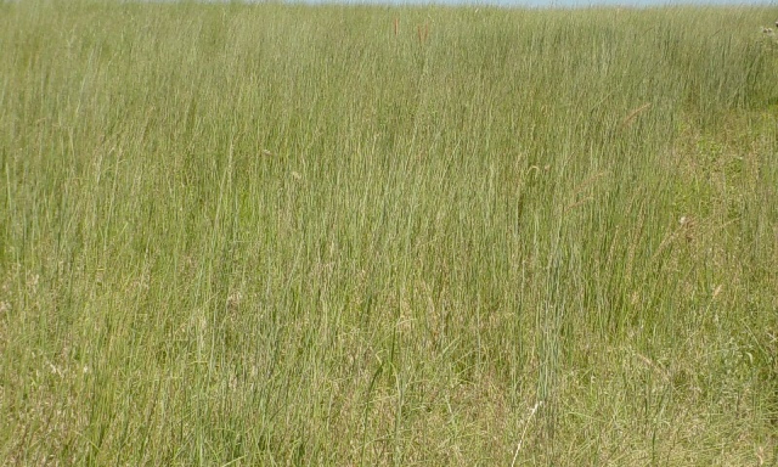
The reference plant community for this site is open tallgrass prairie dominated by big bluestem (in non-sandy areas) or sand bluestem (in the sandy areas), Indiangrass, switchgrass, and little bluestem. The major midgrasses and shortgrasses are sideoats grama, blue grama, dropseed species, and Scribner’s panicum. This site also supports a variety of forbs and legumes including catclaw sensitivebrier, leadplant, wild indigo, heath aster, Englemann's daisy, Maximilian sunflower, dotted gayfeather, western ragweed, Louisiana sagewort, Illinois bundleflower, pitcher's sage, and others. The main lower succession species is prairie three-awn. Scattered prickly pear cactus, and soapweed yucca may be found on this site. This plant community has evolved through the collective influence of extremes in temperature, rain, wind, drought, fire, and seasonal herbivory by large ungulates, primarily bison. The picture was taken in August, 2007 north of Putnam , Custer County, Oklahoma.
Grazing is a common process on Loamy Upland rangeland. Long-term overgrazing (LTO) decreases the more palatable grasses such as big bluestem (Andropogon gerardii, Vitman) and sand bluestem (Andropogon hallii, Hack), Indiangrass, switchgrass as well as palatable forbs and legumes. Under this scenario, coupled with the absence of fire, little bluestem becomes the dominant tallgrass while silver bluestem, prairie three-awn, forbs, other annual grasses, and perennial grasses increase. The rate at which this occurs is dependent upon the initial stocking rate, stocking rate adjustments made during the grazing period, and climatic patterns. In dry years, little bluestem will be the dominant tallgrass. However, when there is high, well-timed precipitation, and fire, the other tallgrasses such as big bluestem, sand bluestem, Indiangrass, and switchgrass dominate to a point where it is difficult to see the little bluestem.
Conservation practices for rangeland use is based upon proper stocking rates and includes prescribed grazing, fencing, water development, proper salt and mineral placement, prescribed burning, and brush management. Depending on the specific site, various combinations of these practices can restore and maintain this plant community indefinitely. Conversely, the absence of grazing, the absence of fire, or both will result in litter buildup and stagnation of ecological functions and subsequent deterioration of the historic plant community.Figure 10. Annual production by plant type (representative values) or group (midpoint values)
Table 5. Annual production by plant type
Plant type Low
(lb/acre)Representative value
(lb/acre)High
(lb/acre)Grass/Grasslike 2186 3718 5253 Forb 317 523 729 Shrub/Vine 22 38 55 Tree 0 0 0 Total 2525 4279 6037 Figure 11. Plant community growth curve (percent production by month). OK0002 , Native Warm Season - North Oklahoma. This is the estimated growth curve for the northern half of Oklahoma where mean annual air temperatures are less than 60 degrees F. Plant growth can vary from year to year dependening on air temperature and timing and amount of precipitation. These figures are merely a representative example for warm season native plants in the geographic area..
Jan Feb Mar Apr May Jun Jul Aug Sep Oct Nov Dec J F M A M J J A S O N D 0 0 3 15 20 30 10 6 10 6 0 0 Community 1.2
Little Bluestem DominantThis plant community is mixed with midgrasses and shortgrasses. The plant community has deviated in composition percentages from the reference and is now dominated by little bluestem. Little bluestem now makes up approximately 60 to 75 percent of the total annual vegetative production of the site. Other important grasses are big bluestem in the clayey areas, or sand bluestem in the sandy areas, Indiangrass, switchgrass, sideoats grama and blue grama. This community, like the reference, also supports a variety of forbs and legumes including catclaw sensitivebrier, heath aster, dotted gayfeather and many others. The predominant lower succession species are prairie three-awn and western ragweed. Scattered mesquite, eastern redcedar, soapweed yucca, or prickly pear cactus may exist. Long-term overgrazing by domestic animals (usually cattle), or severe climate swings towards drier conditions, or drought, contribute to the increase and dominance of little bluestem. This dominance occurs faster as stocking rates increase because cattle prefer other tallgrasses over little bluestem. During years of dry summers followed by mild, wet winters, brome (Bromus spp.) species become significant. Good range management practices such as prescribed grazing, fencing, water development, salt and mineral placement, prescribed burning and prescribed brush management can restore and maintain this plant community indefinitely.
Figure 12. Plant community growth curve (percent production by month). OK0003 , Warm season tallgrasses, forbs, and a few woody species.
Jan Feb Mar Apr May Jun Jul Aug Sep Oct Nov Dec J F M A M J J A S O N D 0 2 6 9 21 24 14 6 11 4 2 1 Community 1.3
Little Little Bluestem Dominant, Beginning Woody Encroachment(At Risk)In this community phase, which basically comes about because of the absence of fire, important grasses are little bluestem, sideoats grama, blue grama, hairy grama, silver bluestem, buffalograss and prairie three-awn. Western ragweed, pricklypear cactus, common broomweed, wavyleaf thistle, and other forbs are abundant. The important change in this state is that woody species have started to encroach upon the site, thus signaling an imminent threshold crossing to a woody grassland is approaching if preventative measures are not taken. Although this change is primarily caused by the lack of or change in fire regime, carry over residue and plant material from ungrazed plants also provides an area for seed germination and protection of seedlings.
Figure 13. Plant community growth curve (percent production by month). OK0004 , Warm season midgrass/shrub.
Jan Feb Mar Apr May Jun Jul Aug Sep Oct Nov Dec J F M A M J J A S O N D 0 1 3 15 25 22 10 8 10 4 1 1 Pathway 1.1A
Community 1.1 to 1.2When abusive grazing practices persist for multiple growing seasons, the plant community may shift towards community phase 1.2.
Pathway 1.2A
Community 1.2 to 1.1With adequate rest from grazing the plant community may shift back towards community phase 1.1. Prescribed fire is also essential to keep woody species in check.
Pathway 1.2B
Community 1.2 to 1.3Without proper grazing and the use of prescribed fire, the plant community may shift to 1.3.
Pathway 1.3A
Community 1.3 to 1.2With the introduction of prescribed fire or alternative brush management, the site may be shifted back to community 1.2. Careful grazing management is also required to ensure productive prescribed fires.
State 2
Woody GrasslandCommunity 2.1
Woody GrasslandIn this plant community, which basically comes about because of the absence of fire, woody species have increased to approximately 50% canopy cover. The two predominant woody invaders are mesquite and eastern redcedar, depending on where the site is located in the MLRA. Basically, eastern redcedar will be more prominent in the north; mesquite will be more prominent in the south. Important grasses are little bluestem, sideoats grama, blue grama, hairy grama, silver bluestem, buffalograss and prairie three-awn. Western ragweed, pricklypear cactus, common broomweed, wavyleaf thistle, and other forbs are abundant. Woody species have "invaded" the site. The two predominant woody invaders are mesquite and eastern redcedar depending on where the site is located in the MLRA (basically, eastern redcedar in the north; mesquite in the south). When the site gets to this state, significant inputs of chemical or mechanical brush control must be utilized to remove eastern redcedar, mesquite and the other brush/shrub species. Depending on the brush control methods used, the site can be either reseeded or implement prescribed grazing practice to create a more desirable (cattle) plant community.
State 3
ConvertedCommunity 3.1
Cropland/TamePastureThis site may be cultivated for crops, planted to permanent native, or introduced pasture species, or let "go back" to native species. Loamy Prairie is one of the most farmed Ecological Sites in the 78C MLRA. But, even though a Loamy Prairie site was in cultivation for a substantial period of time it is not always impossible for the site to return to something resembling the reference state
State 4
ErodedCommunity 4.1
ErodedThis state is the result of water erosion over bare soil. Most of the "A" horizon of the soil profile has been displaced. The remaining subsoil is very low in fertility. Some native grasses and forbs will persist in this state, however, production is greatly reduced.
Transition T1A
State 1 to 2Long term abusive grazing practices coupled with invasion from woody species may transition the site to State 2.
Transition T1B
State 1 to 3Through cultivation and planting the site will be transitioned to State 3.
Restoration pathway R2A
State 2 to 1With the introduction of prescribed fire or alternative brush management, the site may be restored back to State 1. Careful grazing management is also required to ensure productive prescribed fires.
Transition T2A
State 2 to 3Transition T3A
State 3 to 4As soil is lost through water erosion the site will transition to State 4.
Additional community tables
Table 6. Community 1.1 plant community composition
Group Common name Symbol Scientific name Annual production () Foliar cover (%) Grass/Grasslike1 Tallgrasses 1990–4778 Indiangrass SONU2 Sorghastrum nutans 584–1403 – little bluestem SCSC Schizachyrium scoparium 584–1403 – switchgrass PAVI2 Panicum virgatum 340–818 – big bluestem ANGE Andropogon gerardii 231–555 – sand bluestem ANHA Andropogon hallii 231–555 – eastern gamagrass TRDA3 Tripsacum dactyloides 18–41 – 2 Mid & Shortgrasses 44–105 sideoats grama BOCU Bouteloua curtipendula 7–17 – blue grama BOGR2 Bouteloua gracilis 7–17 – lovegrass ERAGR Eragrostis 7–17 – vine mesquite PAOB Panicum obtusum 7–17 – dropseed SPORO Sporobolus 7–17 – tridens TRIDE Tridens 7–17 – 3 Cool-season 30–75 sedge CAREX Carex 10–30 – Scribner's rosette grass DIOLS Dichanthelium oligosanthes var. scribnerianum 10–30 – Canada wildrye ELCA4 Elymus canadensis 10–30 – 4 Mid & Shotgrasses 92–222 splitbeard bluestem ANTE2 Andropogon ternarius 23–55 – prairie threeawn AROL Aristida oligantha 23–55 – silver beardgrass BOLAT Bothriochloa laguroides ssp. torreyana 23–55 – purpletop tridens TRFL2 Tridens flavus 23–55 – Forb5 Legumes 66–155 wild indigo BAPTI Baptisia 8–19 – partridge pea CHFAF Chamaecrista fasciculata var. fasciculata 8–19 – prairie clover DALEA Dalea 8–19 – Illinois bundleflower DEIL Desmanthus illinoensis 8–19 – lespedeza LESPE Lespedeza 8–19 – littleleaf sensitive-briar MIMI22 Mimosa microphylla 8–19 – slimflower scurfpea PSTE5 Psoralidium tenuiflorum 8–19 – 6 Forbs 251–574 common yarrow ACMI2 Achillea millefolium 15–37 – Cuman ragweed AMPS Ambrosia psilostachya 15–37 – white sagebrush ARLU Artemisia ludoviciana 15–37 – yellow sundrops CASE12 Calylophus serrulatus 15–37 – golden tickseed COTI3 Coreopsis tinctoria 15–37 – croton CROTO Croton 15–37 – Engelmann's daisy ENPE4 Engelmannia peristenia 15–37 – prairie fleabane ERST3 Erigeron strigosus 15–37 – common sunflower HEAN3 Helianthus annuus 15–37 – Maximilian sunflower HEMA2 Helianthus maximiliani 15–37 – dotted blazing star LIPU Liatris punctata 15–37 – twistspine pricklypear OPMA2 Opuntia macrorhiza 15–37 – azure blue sage SAAZ Salvia azurea 15–37 – compassplant SILA3 Silphium laciniatum 15–37 – white heath aster SYER Symphyotrichum ericoides 15–37 – soapweed yucca YUGL Yucca glauca 7–18 – leadplant AMCA6 Amorpha canescens 7–18 – Shrub/Vine7 Shrub/vine 22–55 Chickasaw plum PRAN3 Prunus angustifolia 7–18 – sumac RHUS Rhus 7–18 – coralberry SYOR Symphoricarpos orbiculatus 7–18 – Table 7. Community 1.2 plant community composition
Group Common name Symbol Scientific name Annual production () Foliar cover (%) Table 8. Community 1.3 plant community composition
Group Common name Symbol Scientific name Annual production () Foliar cover (%) Table 9. Community 2.1 plant community composition
Group Common name Symbol Scientific name Annual production () Foliar cover (%) Table 10. Community 3.1 plant community composition
Group Common name Symbol Scientific name Annual production () Foliar cover (%) Table 11. Community 4.1 plant community composition
Group Common name Symbol Scientific name Annual production () Foliar cover (%) Interpretations
Animal community
This site is suited for the production of domestic livestock and provides habitat for native wildlife and certain species of exotic wildlife. Cow-calf operations are the primary livestock enterprise although stocker cattle are also common. Sustainable stocking rates have declined drastically over the past 100 years because of deterioration of the historic plant community. Initial starting stocking rates should be determined with the landowner or decision maker based on the merits of the existing plants for the desired animals.
Many species will utilize the site for at least a portion of their habitat needs but rely on a more extensive landscape to meet all their needs. Some animals may only utilize one plant community of the Shallow Upland site to fulfill their habitat needs.
Smaller mammals include many kinds of rodents, jackrabbit, cottontail rabbit, raccoon, skunks, opossum, and armadillo. Mammalian predators include coyote, fox, and bobcat. Many species of snakes and lizards are native to the site.
Many species of birds are found on this site including game birds, songbirds, and birds of prey. Major game birds that are economically important are Rio Grande turkey, bobwhite quail, and mourning dove. Turkey prefers plant communities with substantial amounts of shrubs and trees interspersed with grassland. Quail prefer plant communities with a combination of low shrubs, bunch grass, bare ground, and low successional forbs. The different species of songbirds vary in their habitat preferences. In general, habitat that provides a diversity of grasses, forbs, shrubs, vines and trees, and a complex of grassland, savannah, shrubland, and woodland will support a variety and abundance of songbirds. Birds of prey are important to keep the numbers of rodents, rabbits, and snakes in balance. The different plant communities of the site will sustain different species of raptors.Recreational uses
Camping, fishing, hunting, hiking, bird watching, horseback riding and many other outdoor recreational practices.
Wood products
There are usually very few, if any, woody species on this site. Therefore, there are usually no significant wood products from this site.
Other products
None
Other information
None
Supporting information
Inventory data references
Clipping data and other observations on file in the Oklahoma NRCS State Office: Suite 206 100 USDA Stillwater, Oklahoma 74074 The original information presented here was derived from field observations by Dr. Jack Eckroat, in the summer of 2007, correlated to office files and old Range Site Technical Descriptions (1961 USDA/SCS). Species compositions are as complete as possible. Production will vary by species from within years, from year to year, and from site to site. Production figures are based on limited clipping data, but believed to be the best estimates to date. Production figures are intended to show best estimates of the relationships between the total biomass and hierarchy of the different species.
Other references
Steuter, A.A. and C.M. Britton, 1983. Fire-induced mortality of Redberry Juniper. J. Range Mange. 36:343-345.
Wright, H.A., S.C. Bunting, L.F. Neuenschwander. 1976. Effect of fire on honey mesquite. J. Range Mange. 29:467-471.
*********
This “Approved” site was included in an update project during 2013. The State&Transition model was re-formatted and the ESD was edited to fit the new ESIS format. The concepts and vegetative data contained therein was not altered. The entire ESD will be reviewed, updated, and subjected to the QC/QA processes as part of a future project. CWContributors
Dr. Jack Eckroat, Resource Conservationist, NRCS, Oklahoma
PES Edits by Tyson Morley, MLRA Soil Scientist, Altus, OklahomaApproval
Bryan Christensen, 9/15/2023
Acknowledgments
Site Development and Testing Plan Future work, as described in a Project Plan, to validate the information in this Provisional Ecological Site Description is needed. This will include field activities to collect low, medium and high intensity sampling, soil correlations, and analysis of that data. Annual field reviews should be done by soil scientists and vegetation specialists. A final field review, peer review, quality control, and quality assurance reviews of the ESD will be needed to produce the final document. Annual reviews of the Project Plan are to be conducted by the Ecological Site Technical Team.
Rangeland health reference sheet
Interpreting Indicators of Rangeland Health is a qualitative assessment protocol used to determine ecosystem condition based on benchmark characteristics described in the Reference Sheet. A suite of 17 (or more) indicators are typically considered in an assessment. The ecological site(s) representative of an assessment location must be known prior to applying the protocol and must be verified based on soils and climate. Current plant community cannot be used to identify the ecological site.
Author(s)/participant(s) Jack Eckroat, Harry Fritzler, Steve Glasgow Contact for lead author 100 USDA Suite 206, Stillwater, OK 74074 Date 07/23/2007 Approved by Approval date Composition (Indicators 10 and 12) based on Annual Production Indicators
-
Number and extent of rills:
None -
Presence of water flow patterns:
None -
Number and height of erosional pedestals or terracettes:
None -
Bare ground from Ecological Site Description or other studies (rock, litter, lichen, moss, plant canopy are not bare ground):
<5% -
Number of gullies and erosion associated with gullies:
None -
Extent of wind scoured, blowouts and/or depositional areas:
None -
Amount of litter movement (describe size and distance expected to travel):
Minimal. Short distance movement. Only litter movement would be during high intensity storms. -
Soil surface (top few mm) resistance to erosion (stability values are averages - most sites will show a range of values):
Stability Class 6. Very stable with abundant organic matter in surface. -
Soil surface structure and SOM content (include type of structure and A-horizon color and thickness):
Dark, high organic matter surface, moderately granular. A horizon 4 – 8 inches. -
Effect of community phase composition (relative proportion of different functional groups) and spatial distribution on infiltration and runoff:
None -
Presence and thickness of compaction layer (usually none; describe soil profile features which may be mistaken for compaction on this site):
None -
Functional/Structural Groups (list in order of descending dominance by above-ground annual-production or live foliar cover using symbols: >>, >, = to indicate much greater than, greater than, and equal to):
Dominant:
Warm season tallgrasses > warm season bunchgrasses > warm season sod grassesSub-dominant:
perennial forbsOther:
shrubs and vines > treesAdditional:
Warm season tallgrasses > warm season bunchgrasses > warm season sod grasses > perennial forbs > cool season perennial grasses > shrubs -
Amount of plant mortality and decadence (include which functional groups are expected to show mortality or decadence):
Some mortality and decadence can be expected, but not much. -
Average percent litter cover (%) and depth ( in):
75% at a depth of less than 1 inch. -
Expected annual annual-production (this is TOTAL above-ground annual-production, not just forage annual-production):
Total production is about 2500 pounds per acre in unfavorable years, 6000 pounds in favorable years, averaging 5000 pounds over the long term. -
Potential invasive (including noxious) species (native and non-native). List species which BOTH characterize degraded states and have the potential to become a dominant or co-dominant species on the ecological site if their future establishment and growth is not actively controlled by management interventions. Species that become dominant for only one to several years (e.g., short-term response to drought or wildfire) are not invasive plants. Note that unlike other indicators, we are describing what is NOT expected in the reference state for the ecological site:
Eastern redcedar is a native that will encroach and increase on this site without fire. Eastern redcedar can dominate the site over time. Other woody plants such as mesquite may encroach upon the site, but rarely completely dominate the site unless the site is severely degraded. -
Perennial plant reproductive capability:
All species are capable of reproducing both vegetatively and with seed except during periods of prolonged drought conditions, heavy natural herbivory or intense wildfires.
Print Options
Sections
Font
AAAAOther
PrintThe Ecosystem Dynamics Interpretive Tool is an information system framework developed by the USDA-ARS Jornada Experimental Range, USDA Natural Resources Conservation Service, and New Mexico State University.
Accessibility statement


