
Natural Resources
Conservation Service
-
Search


Major Land Resource Area or ecological site by name and/or ID.
PreviousSectionsNextGeneral information
Provisional. A provisional ecological site description has undergone quality control and quality assurance review. It contains a working state and transition model and enough information to identify the ecological site.
Click to explore map
Figure 1. Mapped extent
Areas shown in blue indicate the maximum mapped extent of this ecological site. Other ecological sites likely occur within the highlighted areas. It is also possible for this ecological site to occur outside of highlighted areas if detailed soil survey has not been completed or recently updated.
MLRA notes
Major Land Resource Area (MLRA): 078C–Central Rolling Red Plains, Eastern Part
MLRA 78C is characterized by moderately dissected, rolling plains with prominent ridges and valleys and numerous terraces adjacent to dissecting streams. Loamy and clayey soils are generally deep, well drained, and developed in calcareous and gypsiferous sediments of Permian age.
LRU notes
NA
Classification relationships
This ecological site is correlated to soil components at the Major Land Resource Area (MLRA) level which is further described in USDA Ag Handbook 296.
Ecological site concept
These sites occur on shallow soils over gypsum. The vegetation can vary depending on gypsum content in the soils. Generally the reference vegetation will consist of midgrasses, shortgrasses, with smaller amounts of shrubs and forbs. Major grasses include little bluestem and common shrubs are broom snakeweed and yucca. If these sites are subjected to abusive grazing, the plant community may shift to one dominated by less palatable species.
Associated sites
R078CY006OK Clayey Breaks
Fine textured soils on Breaks from Gyp caps. >20% Slopes.
Similar sites
R078BY076TX Gyp 19-26" PZ
Gyp site in 78B
Table 1. Dominant plant species
Tree Not specified
Shrub Not specified
Herbaceous (1) Schizachyrium scoparium
(2) Gutierrezia sarothraePhysiographic features
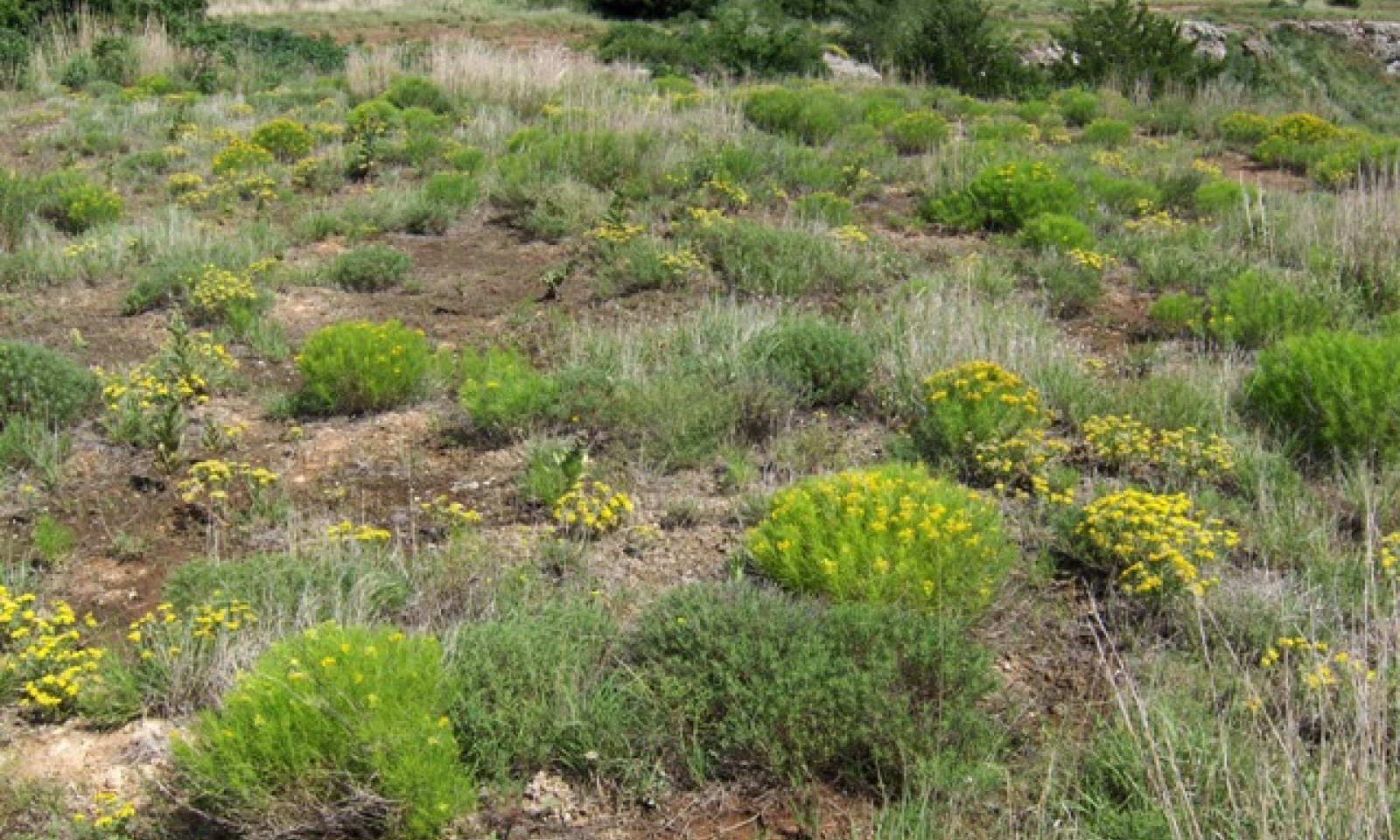
This site occurs as ridges, knobs, hilltops, and benches within the redbed geologic formations of the western rolling plains. In general, these sites do not comprise large acreages and are found within larger associated sites. Slopes range from nearly level to moderately steep. Raw gypsum is visible on the surface.

Figure 2. Gyp
Table 2. Representative physiographic features
Landforms (1) Plains > Ridge
(2) Plains > Hill
(3) Plains > Knob
Runoff class High to very high Flooding frequency None Ponding frequency None Elevation 1000 – 2600 ft Slope 1 – 20 % Aspect Aspect is not a significant factor Climatic features
MLRA 78C extends north and south from Coldwater, Kansas to just northeast of San Angelo, Texas (Ballinger, Texas), and east to west from Weatherford, Oklahoma to west of Shamrock, Texas. The weather is alternately influenced by cold dry air from the Arctic Circle, and warm moist air from the Gulf of Mexico. Seasonal changes are gradual. Spring is a season of variable weather and relatively high precipitation with prevailing winds from the southwest. Summers are generally hot with low humidity. Fall has long periods of pleasant weather interspersed with moderate to heavy rains. Winter is open and moderate to cold with winds from the north and infrequent snows. Approximately 75 percent of the rainfall occurs during the warm season, and much of it comes in storms of high intensity and short duration in May and June. These rains can be particularly erosive on sites where vegetation is sparse. Occasional droughts are to be expected. Lack of rainfall and hot, dry winds often curtail forage production during July and August.
Table 3 Representative climatic features
Frost-free period (characteristic range) 160-200 days Freeze-free period (characteristic range) 190-220 days Precipitation total (characteristic range) 30-30 in Frost-free period (actual range) 150-210 days Freeze-free period (actual range) 190-230 days Precipitation total (actual range) 30-30 in Frost-free period (average) 180 days Freeze-free period (average) 210 days Precipitation total (average) 30 in Characteristic rangeActual rangeBarLineFigure 3. Monthly precipitation range
Characteristic rangeActual rangeBarLineFigure 4. Monthly minimum temperature range
Characteristic rangeActual rangeBarLineFigure 5. Monthly maximum temperature range
BarLineFigure 6. Monthly average minimum and maximum temperature
Figure 7. Annual precipitation pattern
Figure 8 Annual average temperature pattern
Climate stations used
-
(1) COLDWATER [USC00141704], Coldwater, KS
-
(2) TALOGA [USC00348708], Taloga, OK
-
(3) CLINTON SHERMAN AP [USW00003932], Dill City, OK
-
(4) LAKE KEMP [USC00414982], Seymour, TX
-
(5) ANSON 3ESE [USC00410268], Anson, TX
">Influencing water features
Gypsum is highly water soluble and numerous cavities can occur in these concentrated gyp deposits.
Wetland description
NA
Soil features
Soils of this site consist of shallow or very shallow, well drained, moderately permeable soils that formed in loamy residuum over gypsum bedrock of Permian age. These soils are on nearly level to strongly sloping hills and ridges. They occur on summits and side slopes of hills and on ridges and benches. The gypsum content varies and is the limiting factor to the kind and amount of vegetation present.
Representative Soils: Cornick, CottonwoodTable 4. Representative soil features
Parent material (1) Residuum – rock gypsum
Surface texture (1) Silt loam
(2) Loam
Family particle size (1) Loamy
Drainage class Well drained Permeability class Moderate Soil depth 5 – 10 in Surface fragment cover <=3" Not specified Surface fragment cover >3" Not specified Available water capacity
(0-40in)0.9 – 2.4 in Calcium carbonate equivalent
(0-40in)5 – 30 % Electrical conductivity
(0-40in)0 – 4 mmhos/cm Sodium adsorption ratio
(0-40in)0 – 4 Soil reaction (1:1 water)
(0-40in)7.9 – 8.4 Subsurface fragment volume <=3"
(Depth not specified)0 – 3 % Subsurface fragment volume >3"
(Depth not specified)Not specified Ecological dynamics
The plant community on this site is influenced by the gypsum content more than by any other factor. Where the gyp content is very high, the vegetation is sparse and plant species very limited. Where there has been some significant soil formation over the gypsum beds, the vegetation is denser and there are a wider range of species present. At best, the production for the site is low and the plants are not very palatable to livestock. It is not a site that is attractive for livestock grazing. It generally occurs as fairly small areas occurring within an associated site of considerably more acres. The gypsum can occur as bedded strata, or as a platy crystalline form on the soil surface. Any sort of mechanical activity on this site (including heavy animal traffic) results in making the gypsum more concentrated. Livestock will sometimes graze the site but in general, overuse of the site is rare. It is a fragile site due to lack of plant growth to protect the soil surface. Since gypsum is highly water soluble, cavities can develop beneath the soil surface. Sometimes in walking over the site a hollow sound is produced and instances of "cave-ins" have occurred. Large "gyp sinks" sometimes occur in areas underlain by gypsum that has dissolved over the years.
The reference vegetation for the site consists of relatively few species compared to other sites. It is primarily a grassland community with a few forbs and very few shrubs. The grasses are mainly tall and mid grass species. Little bluestem (Schizachyrium scoparium) is typically the most predominant species. Other grass species included sideoats grama (Bouteloua curtipendula), wright threeawn (Aristida wrightii), sand dropseed (Sporobolus cryptandrus), hairy grama (Bouteloua hirsuta), blue grama (Bouteloua gracilis) and hairy tridens (Erioneuron pilosum). Occasionally tobosa (Hilaria mutica) was found on sites in the far southern parts of the MLRA. On sites where more soil material exists, big bluestem (Andropogon gerardii) and Indiangrass (Sorghastrum nutans) could be found in small quantities When the site is covered with gyp outcrop, a variety of shortgrasses and forbs could be found.
The main forb species found include brrom snakeweed (Gutierrezia sarothrae), gyp bluecurls (Phacelia integrifolia), halfshrub sundrop (Mentzelia strictissima), Missouri primrose (Oenothera missouriensis), bushy primrose (Oenothera drummondii), false broomweed (Haploesthes greggii) and annual broomweed (Gutierrezia dracunculoides). The main shrubs and trees found on the site are: feather dalea (Dalea formosa), Yucca (Yucca glauca), catclaw mimosa (Mimosa biuncifera), and occasionally skunkbush sumac (Rhus trilobata). Occasionally, eastern redcedar (Juniperus virginiana) and prickly pear cactus (Opuntia polycantha) can be found in small amount also.
Natural fire may not have been important on this site due to sparse cover which limited fuel for fire. Many of these sites do not produce enough continuity of fuels to allow a complete burn. There is limited use of the site by wildlife. Cover is sparse and woody plants few, thereby limiting it for habitat. Deer will sometimes graze the forbs and browse the short shrubs.
Plant Communities and Transitional Pathways (diagram):
The following diagram suggests some pathways that the vegetation on this site might take. There may be other states not shown on the diagram. This information is intended to show what might happen in a given set of circumstances; it does not mean that this would happen the same way in every instance. Local professional guidance should always be sought before pursuing a treatment scenario.State and transition model
More interactive model formats are also available. View Interactive Models
Click on state and transition labels to scroll to the respective textEcosystem states
State 1 submodel, plant communities
State 1
GrasslandCommunity 1.1
Tallgrass/Midgrass Community
Figure 9. Tallgrass, Midgrasses, Shortgrasses
The reference plant community consisted of mainly Little bluestem. A few scattered yucca and a few forbs are present. Distance between plants will vary depending on amount of gyp outcrop.
Figure 10. Annual production by plant type (representative values) or group (midpoint values)
Table 5. Annual production by plant type
Plant type Low
(lb/acre)Representative value
(lb/acre)High
(lb/acre)Grass/Grasslike 650 910 1170 Forb 300 420 540 Shrub/Vine 30 42 54 Tree 20 28 36 Total 1000 1400 1800 Figure 11. Plant community growth curve (percent production by month). OK0001 , Native, Warm Season Grasses. Typically, the summer growing season for warm season grasses begins April 5 to 15 and ends October 15 to 25. Nearly three-fourths of the season production will occur before the first of July. This varies from year to year depending upon temperatures and precipitation..
Jan Feb Mar Apr May Jun Jul Aug Sep Oct Nov Dec J F M A M J J A S O N D 0 1 5 10 20 30 10 5 10 6 2 1 Community 1.2
Midgrass/Shortgrass Community
Figure 12. Midgrass, Tallgrass, Shortgrass
Sparse community of midgrass and shortgrasses with forbs and cacti. Halfshrub sundrop, wright three-awn, and scattered grama species are dominant species in this community. Large bare areas are developing as plant density on the site decreases. Lower annual production due to higher gyp content.
Figure 13. Annual production by plant type (representative values) or group (midpoint values)
Table 6. Annual production by plant type
Plant type Low
(lb/acre)Representative value
(lb/acre)High
(lb/acre)Grass/Grasslike 75 120 150 Forb 25 30 40 Shrub/Vine 0 5 10 Tree 0 0 0 Microbiotic Crusts 0 0 0 Total 100 155 200 Community 1.3
Scattered tall and midgrass community
Figure 14. Shortgrasses, Midgrasses, few if any Tallgrasses
Few perennial grasses and a few forbs are left in this plant community. Very sparse vegetation due to increase of basre ground and high gyp content in the soil. There is an increase of shrubs and cacti on the site. Dominant plant species in this community include little bluestem, sand lily and yucca.
Figure 15. Annual production by plant type (representative values) or group (midpoint values)
Table 7. Annual production by plant type
Plant type Low
(lb/acre)Representative value
(lb/acre)High
(lb/acre)Grass/Grasslike 80 130 200 Forb 10 15 20 Shrub/Vine 10 15 20 Tree 0 0 0 Microbiotic Crusts 0 0 0 Total 100 160 240 Pathway 1.1A
Community 1.1 to 1.2
Tallgrass/Midgrass Community
Midgrass/Shortgrass CommunityLong term abusive grazing practices or mechanical soil disturbance may push the plant community towards 1.2.
Pathway 1.2A
Community 1.2 to 1.3
Midgrass/Shortgrass Community
Scattered tall and midgrass communityLong term abusive grazing practices or mechanical soil disturbance may push the plant community towards 1.2.
Pathway 1.3A
Community 1.3 to 1.2
Scattered tall and midgrass community
Midgrass/Shortgrass CommunityWith rest from grazing and soil disturbing activity, the site may be shifted back toward community phase 1.2. This may take a period of years.
Additional community tables
Table 8. Community 1.1 plant community composition
Group Common name Symbol Scientific name Annual production () Foliar cover (%) Grass/Grasslike1 Tall Grasses 250–450 little bluestem SCSC Schizachyrium scoparium 200–360 – Indiangrass SONU2 Sorghastrum nutans 0–90 – sand bluestem ANHA Andropogon hallii 50–90 – switchgrass PAVI2 Panicum virgatum 0–90 – 2 Mid-grasses 300–540 sideoats grama BOCU Bouteloua curtipendula 200–360 – silver beardgrass BOLAT Bothriochloa laguroides ssp. torreyana 0–90 – tumble windmill grass CHVE2 Chloris verticillata 0–90 – marsh bristlegrass SEPA10 Setaria parviflora 0–90 – composite dropseed SPCOC2 Sporobolus compositus var. compositus 0–90 – sand dropseed SPCR Sporobolus cryptandrus 50–90 – slim tridens TRMUE Tridens muticus var. elongatus 0–90 – longspike tridens TRST2 Tridens strictus 0–90 – purple threeawn ARPU9 Aristida purpurea 50–90 – 3 Shortgrasses 100–180 blue grama BOGR2 Bouteloua gracilis 50–90 – hairy grama BOHI2 Bouteloua hirsuta 0–90 – vine mesquite PAOB Panicum obtusum 0–90 – Forb4 Forbs 300–540 prairie broomweed AMDR Amphiachyris dracunculoides 50–90 – Indian paintbrush CASTI2 Castilleja 0–90 – prairie clover DALEA Dalea 0–90 – purple prairie clover DAPU5 Dalea purpurea 0–90 – Illinois bundleflower DEIL Desmanthus illinoensis 0–90 – broom snakeweed GUSA2 Gutierrezia sarothrae 50–90 – Maximilian sunflower HEMA2 Helianthus maximiliani 50–90 – stiffleaf false goldenaster HESTS Heterotheca stenophylla var. stenophylla 0–90 – hairy false goldenaster HEVI4 Heterotheca villosa 50–90 – bluet HOUST Houstonia 0–90 – indigo INDIG Indigofera 0–90 – slender lespedeza LEVI7 Lespedeza virginica 0–90 – dotted blazing star LIPU Liatris punctata 50–90 – grassland blazingstar MEST3 Mentzelia strictissima 0–90 – evening primrose OENOT Oenothera 50–90 – nailwort PARON Paronychia 0–90 – slimflower scurfpea PSTE5 Psoralidium tenuiflorum 0–90 – pitcher sage SAAZG Salvia azurea var. grandiflora 0–90 – skullcap SCUTE Scutellaria 0–90 – greenthread THELE Thelesperma 0–90 – bluecurls TRICH9 Trichostema 0–90 – Rocky Mountain zinnia ZIGR Zinnia grandiflora 0–90 – Shrub/Vine5 Shrub/Vine 30–54 pricklypear OPUNT Opuntia 0–54 – skunkbush sumac RHTRT Rhus trilobata var. trilobata 0–54 – yucca YUCCA Yucca 0–54 – Tree6 Trees 20–36 eastern redcedar JUVI Juniperus virginiana 20–36 – Pinchot's juniper JUPI Juniperus pinchotii 0–5 – Table 9. Community 1.2 plant community composition
Group Common name Symbol Scientific name Annual production () Foliar cover (%) Table 10. Community 1.3 plant community composition
Group Common name Symbol Scientific name Annual production () Foliar cover (%) Interpretations
Animal community
Lack of cover and palatable food plants limit animal usage, particularly livestock. Small mammals, lizards, snakes, songbirds, bobwhite quail, muledeer.
Hydrological functions
Contributes runoff to nearby drainages
Recreational uses
Hunting, Camping, Hiking, Birdwatching, Photography, Horseback
Wood products
None
Other products
None
Other information
None
Supporting information
Inventory data references
NRCS - Section II FOTG - Range Site Descriptions. Historical NRCS Clipping data Field visits and evaluations
Other references
*****
This “Approved” site was included in an update project during 2013. The State&Transition model was re-formatted and the ESD was edited to fit the new ESIS format. The concepts and vegetative data contained therein was not altered. The entire ESD will be reviewed, updated, and subjected to the QC/QA processes as part of a future project. CWContributors
Dr. Jack Eckroat, Grazing Lands Specialist, NRCS, Oklahoma
PES Edits by Tyson Morley, MLRA Soil Scientist, Altus, OklahomaApproval
Bryan Christensen, 9/15/2023
Acknowledgments
Site Development and Testing Plan Future work, as described in a Project Plan, to validate the information in this Provisional Ecological Site Description is needed. This will include field activities to collect low, medium and high intensity sampling, soil correlations, and analysis of that data. Annual field reviews should be done by soil scientists and vegetation specialists. A final field review, peer review, quality control, and quality assurance reviews of the ESD will be needed to produce the final document. Annual reviews of the Project Plan are to be conducted by the Ecological Site Technical Team.
Rangeland health reference sheet
Interpreting Indicators of Rangeland Health is a qualitative assessment protocol used to determine ecosystem condition based on benchmark characteristics described in the Reference Sheet. A suite of 17 (or more) indicators are typically considered in an assessment. The ecological site(s) representative of an assessment location must be known prior to applying the protocol and must be verified based on soils and climate. Current plant community cannot be used to identify the ecological site.
Author(s)/participant(s) Jack Eckroat Contact for lead author 100 USDA Suite 206 Stillwater, OK 74074 Date 12/01/2008 Approved by Approval date Composition (Indicators 10 and 12) based on Annual Production Indicators
-
Number and extent of rills:
Very few rills. -
Presence of water flow patterns:
Distinct, particularly on steeper slopes. Not usually more than 6 inches deep. -
Number and height of erosional pedestals or terracettes:
Common around small rocks and bunchgrasses but usually not more than 1-2 inches deep. -
Bare ground from Ecological Site Description or other studies (rock, litter, lichen, moss, plant canopy are not bare ground):
40-50% (Rock 2-25%) -
Number of gullies and erosion associated with gullies:
Shallow soils limit the formation of anything but small gullies. Usually on steeper slopes and less than 2 feet deep and 3 feet wide. Some geological erosion may occur on this site. -
Extent of wind scoured, blowouts and/or depositional areas:
None. -
Amount of litter movement (describe size and distance expected to travel):
Litter may move 1-3 feet after high intensity rainfall event. It is difficult to maintain litter on exposed soil, particularly on the areas of increased slopes. -
Soil surface (top few mm) resistance to erosion (stability values are averages - most sites will show a range of values):
Soil stability scores of 4+. -
Soil surface structure and SOM content (include type of structure and A-horizon color and thickness):
See Official Soil Series Description for representive soils which include Cornick and Cottonwood. -
Effect of community phase composition (relative proportion of different functional groups) and spatial distribution on infiltration and runoff:
Mid-grass (little bluestem, sideoats grama), short grass/shrub community randomly dispersed. Slopes and very slowly permeable soils result in high runoff. -
Presence and thickness of compaction layer (usually none; describe soil profile features which may be mistaken for compaction on this site):
No compaction layer but fine texture and hard structure can be mistaken for compaction layer. -
Functional/Structural Groups (list in order of descending dominance by above-ground annual-production or live foliar cover using symbols: >>, >, = to indicate much greater than, greater than, and equal to):
Dominant:
Mid-grass (little bluestem, sideoats)> sod grassesSub-dominant:
warm-season perennial forbs > tallgrass> shrubs > cool season grasses and grasslikesOther:
Additional:
-
Amount of plant mortality and decadence (include which functional groups are expected to show mortality or decadence):
Due to the droughty nature of this site, some mortality will occur, especially with three-awns, sideoats grama and little bluestem. Death loss could be around 10%, higher in extremely dry, hot years. -
Average percent litter cover (%) and depth ( in):
Litter cover should average 5 - 30% and less than ½ inch depth. Basal cover approximately 5 - 10%. -
Expected annual annual-production (this is TOTAL above-ground annual-production, not just forage annual-production):
Normal Production is from 1,000-1,800lbs/ac -
Potential invasive (including noxious) species (native and non-native). List species which BOTH characterize degraded states and have the potential to become a dominant or co-dominant species on the ecological site if their future establishment and growth is not actively controlled by management interventions. Species that become dominant for only one to several years (e.g., short-term response to drought or wildfire) are not invasive plants. Note that unlike other indicators, we are describing what is NOT expected in the reference state for the ecological site:
Main invasives are eastern redcedar. -
Perennial plant reproductive capability:
All plants capable of reproducing at least every 2 – 3 years.
Print Options
Sections
Font
AAAAOther
PrintThe Ecosystem Dynamics Interpretive Tool is an information system framework developed by the USDA-ARS Jornada Experimental Range, USDA Natural Resources Conservation Service, and New Mexico State University.
Accessibility statement


