
Natural Resources
Conservation Service
-
Search


Major Land Resource Area or ecological site by name and/or ID.
PreviousSectionsNextGeneral information
Provisional. A provisional ecological site description has undergone quality control and quality assurance review. It contains a working state and transition model and enough information to identify the ecological site.
Click to explore map
Figure 1. Mapped extent
Areas shown in blue indicate the maximum mapped extent of this ecological site. Other ecological sites likely occur within the highlighted areas. It is also possible for this ecological site to occur outside of highlighted areas if detailed soil survey has not been completed or recently updated.
MLRA notes
Major Land Resource Area (MLRA): 078B–Central Rolling Red Plains, Western Part
MLRA 78B is characterized by strongly dissected, rolling plains with prominent ridges
and valleys and rolling to steep irregular topography. Loamy soils are generally well
drained, range from shallow to deep, and developed in sediments of Triassic and
Permian age.LRU notes
NA
Classification relationships
This ecological site is correlated to soil components at the Major Land Resource Area (MLRA) level which is further described in USDA Ag Handbook 296.
Ecological site concept
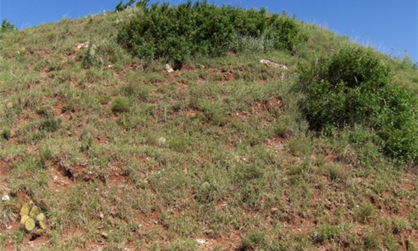
This site occurs on shallow clay soils on steep slopes and escarpments. Badland areas are often intermingled with these sites. Production is low and highly variable depending on soil resources, slope, and aspect. Reference vegetation consists of shortgrasses with some midgrasses and forbs along with scattered shrubs. While grazing may not be associated with this site due to the slope, periodic fires have shaped the plant community. Without periodic fire, the woody species canopy may expand on the site.
Associated sites
R078BY090TX Shallow Clay 19-26" PZ
Similar clay soils but deeper and less slope.
R078BY092TX Very Shallow Clay 19-26" PZ
Same soils. Less slope. Tends to have more invading mesquite. More likely to have grazing impacts.
Similar sites
R078CY006OK Clayey Breaks
This is a very similar site in the northern portions of the rolling red plains.
Table 1. Dominant plant species
Tree (1) Juniperus pinchotii
Shrub (1) Dalea formosa
(2) Rhus trilobataHerbaceous (1) Bouteloua hirsuta
(2) Bouteloua curtipendulaPhysiographic features
These sites are located along clayey ridges and escarpments with slopes ranging from
12-40%. With slopes in this range, land use and management practices are quite limited
when compared to adjacent sites.
Figure 2. R078BY094TX

Figure 3. R078BY094TX
Table 2. Representative physiographic features
Landforms (1) Breaks > Hill
(2) Breaks > Escarpment
Runoff class Very high Flooding frequency None Ponding frequency None Elevation 1000 – 2000 ft Slope 12 – 40 % Aspect Aspect is not a significant factor Climatic features
The climate of the western rolling plains is dry, sub-humid with hot summers and mild winters. Temperatures often reach 100 degrees F for several consecutive days during summer. Cold spells with temperatures less than 20 degrees F only last short periods of time. The soil is not frozen below the 3-inch depth for more than 2 to 3 days. Humidity is low during the winter and early spring months. Sometimes relative humidity is high enough to make summer days seem uncomfortable. Most of the precipitation comes in the form of rain and that in the spring and early summer principally. May is the wettest month followed by June. July and August are dryer and much hotter. Rainfall often comes as intense showers of relatively short duration. Rainfall rate per hour is often high and runoff is significant. Infiltration is diminished due to lack of opportunity time. The growing season begins in April and ends with the first killing frost in Nov.
There is little snowfall with the average being about 10 inches. Rainfall averages about 22 inches.
There is a 70% chance that yearly precipitation will fall between 16 and 24 inches. About 55% of the time, the yearly rainfall is below the mean. Dry spells during the growing season are common and long-term droughts occur in cycles of about 20 years. Native vegetation is principally warm season.Table 3 Representative climatic features
Frost-free period (characteristic range) 170-190 days Freeze-free period (characteristic range) 200-220 days Precipitation total (characteristic range) 20-30 in Frost-free period (actual range) 170-200 days Freeze-free period (actual range) 200-220 days Precipitation total (actual range) 20-30 in Frost-free period (average) 190 days Freeze-free period (average) 210 days Precipitation total (average) 20 in Characteristic rangeActual rangeBarLineFigure 4. Monthly precipitation range
Characteristic rangeActual rangeBarLineFigure 5. Monthly minimum temperature range
Characteristic rangeActual rangeBarLineFigure 6. Monthly maximum temperature range
BarLineFigure 7. Monthly average minimum and maximum temperature
Figure 8. Annual precipitation pattern
Figure 9 Annual average temperature pattern
Climate stations used
-
(1) ROBERT LEE [USC00417669], Robert Lee, TX
-
(2) SHAMROCK 2 [USC00418236], Shamrock, TX
-
(3) COPPER BREAKS SP [USC00411995], Quanah, TX
-
(4) POST [USC00417206], Post, TX
-
(5) ROSCOE [USC00417743], Roscoe, TX
-
(6) CLARENDON [USW00023072], Clarendon, TX
">Influencing water features
These sites are in an upland position of "Run-Off" hydrology. Water is shed from these sites on to to lower positions on the landscape.
Wetland description
NA

Figure 10. Hydrologic Cycle
Soil features
Soils are mapped for each county within the MLRA. Mapunits are representations of the major soil series component(s) and named accordingly. Each Mapunit is spatially represented on a digital soils map as polygons of different shapes and sizes. Within these Mapunits, there are often minor soil series components included. These minor components are soils that occur within a Mapunit polygon but are of small extent (15% or less of the Mapunit area). However, it is difficult to separate these minor soils spatially due to the scale of soil mapping.
Ecological sites are correlated at the component level of the soil survey. Therefore, a single Mapunit may contain multiple Ecological Sites just as it may contain multiple soil components. This is important to understand when investigating soils and Ecological Sites. A soil survey Mapunit may be correlated to a single Ecological Site based on the major component; however, there may be inclusional areas of additional Ecological Sites which are correlated to the minor components of that particular soil Mapunit.
The soils associated with this ecological site consist of very shallow and shallow, well
drained, very slowly permeable soils that formed in residuum over dense non-cemented
claystone bedrock of Permian age. These soils are on very steep ridges, sideslopes,
on uplands. Slopes range from 12 to 40 percent.
Representative soil is Knoco.Table 4. Representative soil features
Parent material (1) Residuum – claystone
Surface texture (1) Clay
(2) Clay loam
(3) Sandy clay
Family particle size (1) Clayey
Drainage class Well drained Permeability class Very slow Soil depth 3 – 20 in Surface fragment cover <=3" 0 – 2 % Surface fragment cover >3" 0 – 2 % Available water capacity
(0-40in)0.8 – 2 in Calcium carbonate equivalent
(0-40in)1 – 8 % Electrical conductivity
(0-40in)1 – 8 mmhos/cm Sodium adsorption ratio
(0-40in)0 – 8 Soil reaction (1:1 water)
(0-40in)7.4 – 8.4 Subsurface fragment volume <=3"
(Depth not specified)0 – 6 % Subsurface fragment volume >3"
(Depth not specified)0 – 7 % Ecological dynamics
The vegetation within the reference state is a mixture of grasses, forbs, shrubs, and a few trees. The percent of bare ground can sometimes be fairly high in comparison to adjacent sites. Aspect, climate, soil depth, percent slope, and disturbance factors are all important determinants in the overall species composition and production of the plant community. This is especially true for a Clayey Breaks site. Generally the north and east facing exposures have a greater variety of plants present and slightly higher production due to slightly cooler and wetter conditions. Forage production is generally less than sites with deeper soil resources. Accessibility is limited due to steep slopes.
Midgrass, tallgrass, and shortgrass species are found on the site along with several species of forbs and shrubs. Little bluestem (Schizachyrium scoparium) and sideoats grama Bouteloua curtipendula) are often the most common grasses; however, other grasses such as hairy grama (Bouteloua hirsuta), blue grama (Bouteloua gracilis), and perennial three-awn (Aristida purpurea) are also found on the shallower areas. Big bluestem (Andropogon gerardii), Indiangrass (Sorghastrum nutans), and dropseed species (Sporobolus spp.) are usually found in crevices and deeper soil areas. Common shrubs are feather dalea (Dalea spp.), skunkbush sumac (Rhus tribolata), and redberry juniper (Juniperus pinchotii). Areas occur within the site where the shrubs may be quite prominent and make up a fairly large percent of the total biomass; and there will be areas where grasses and forbs dominate. This site is not a preferred grazing area for most domestic livestock due to accessibility (steep slopes) and shallow soils. Therefore, this site is seldom heavily grazed. Browsing wildlife species such as white tailed deer frequent this site because of the good variety of forbs and shrubs providing food and cover in the canyons. A considerable amount of geologic erosion usually takes place on this site; therefore, any amount of native plant cover that can be supported is desirable. Both natural and anthropogenic fire played a role in the ecology of this site as is true for most Central Rolling Red Plains sites. The general effects of these fires were woody plant suppression and increased vigor of herbaceous plants. However, some of the steeper slopes and canyon walls escaped fire altogether. In general, the rocky soils and steep terrain of this site have much more influence on the plant community than does any external ecological influence. The sparse vegetation and lower production affects fine fuel continuity, and the heat generated by natural fire may have limited the degree of damage to woody plants. It is important to note that it might take this site longer to recover from a burn than most associated sites due to sparse plant density and droughty soils. Since the site is not normally heavily grazed, the overall ecological condition will not be affected as much due to animal use. There are places where on the most accessible part of the site, there is evidence of grazing by cattle. The grazing tends to be somewhat seasonal and for shorter duration than more productive less sloping terrain. However, if the site were grazed by goats instead of cattle, then overgrazing and browsing could be more of a potential problem. Most species of deer utilize the site readily, but in most places , deer populations are not dense enough to place a lot of pressure on primary browse. In most cases, this site is more important for wildlife habitat than for livestock grazing.
A State and Transition Diagram for the Clayey Breaks site is depicted below. Descriptions of each state, transition, and pathway follow the model. Experts base this model on available experimental research, field observations, professional consensus, and interpretations. It is likely to change as knowledge increases.
Plant communities will differ across the MLRA because of the natural variability in weather, soils, and aspect. The Reference State may not always be the management goal. The biological processes on this site are complex. Therefore, representative values are presented in a land management context. The species lists are representative and are not botanical descriptions of all species occurring,
or potentially occurring, on this site. They are not intended to cover every situation or the full range of conditions, species, and responses for the site.State and transition model
More interactive model formats are also available. View Interactive Models
Click on state and transition labels to scroll to the respective textEcosystem states
T1A - Absence of disturbance and natural regeneration over time, may be coupled with excessive grazing pressure R2A - Adequate rest from defoliation and removal of woody canopy, followed by reintroduction of historic disturbance regimes State 1 submodel, plant communities
State 2 submodel, plant communities
State 1
Reference StateThis is the reference ecological state for the Clayey Breaks site. It represents the natural range of variability within the plant community over the course of its development. It takes into consideration the variability in precipitation patterns from year to year and the frequency and timing of fires. During wetter periods, the overall production and species composition of the site may differ from long dry periods. Also, the site may have burned consecutive years during some periods and not burned at all for multiples years. These variation in plant community diversity and structure are considered normal and expected on the site.
Dominant plant species
-
Pinchot's juniper (Juniperus pinchotii), tree
-
featherplume (Dalea formosa), shrub
-
hairy grama (Bouteloua hirsuta), grass
-
sideoats grama (Bouteloua curtipendula), grass
Community 1.1
Shortgrass/Midgrass
Figure 11. Clayey Breaks Reference State
This plant community is part of the natural variability of the Clayey Breaks site. It is co-dominated by warm season midgrasses and shortgrasses. Tallgrass species are often present in areas of deeper soil resources and can make up a significant amount of herbaceous production. Many perennial native forbs are present along with many different species of woody shrubs. Periodic fires have historically kept the woody canopy cover under 30 percent. Some areas of higher canopy may exist around rocky outcrops or barren areas that are protected from fire.
Due to the slope of the Clayey Breaks site, it is rarely used by grazing animals. Grazing is usually possible only on the footslopes where the Clayey Breaks site transitions to a different site. Browsing wildlife species and domestic goats may utilize the site much more than cattle or horses.
There is very limited production data on these sites but estimates have been made. Overall annual production (woody and herbaceous) on the Clay Breaks site is estimated to range from 900 to 1,500 pounds per acre.Community 1.2
Shortgrass/Annuals/ShrubsThis plant community is part of the natural variability of the Clayey Breaks site. There is an increase in shortgasses and annual forbs as the vigor of the midgrass and tallgrass species has declined. Perennial forbs may also decline leading to increased bare ground and the opportunistic annual plants. Increased shrub canopy may also occur in this community depending on time since fire.
Pathway 1.1A
Community 1.1 to 1.2With prolonged dry periods, the plant community may shift towards community 1.2. Fire exclusion can also contribute to this shift by allowing woody species canopy to expand.
Pathway 1.2A
Community 1.2 to 1.1With periodic fire and favorable growing season moisture, this plant community may shift back to plant community 1.1.
State 2
Shrub DominatedThis ecological state is the result of long term fire exclusion. Without periodic fires to suppress the woody species, they have increased in canopy size and abundance. Several ecological process are altered as a result. The hydrologic cycle is disrupted by both rainfall interception and excessive use by the more prolific shrub species. Energy flow is dominated by the shrubs which can shade out many of the other herbaceous plants. Overall biomass production may be similar to the reference state, however the majority is made up of woody species production.
Dominant plant species
-
Pinchot's juniper (Juniperus pinchotii), tree
-
featherplume (Dalea formosa), shrub
-
skunkbush sumac (Rhus trilobata), shrub
Community 2.1
Shrub Dominated
Figure 12. Shrub Dominated
Transition T1A
State 1 to 2With long term fire exclusion (10+ years), this site may transition to a shrub dominated ecological state. Without fire or alternative brush management methods, the woody species will begin to dominate the ecological processes.
Restoration pathway R2A
State 2 to 1It is believed that this shrub dominated state can be returned to the reference state. This restoration must involve the reintroduction of fire through prescribed burning. Potentially, other brush management practices may be needed in order to expedite the processes. Caution should be used if any mechanical brush treatment is applied as the erosion potential may be high on the steep slopes. Depending on weather patterns, fuel continuity, and remaining reference state species, this process could take many years(10+).
Additional community tables
Table 5. Community 1.1 plant community composition
Group Common name Symbol Scientific name Annual production () Foliar cover (%) Table 6. Community 1.2 plant community composition
Group Common name Symbol Scientific name Annual production () Foliar cover (%) Table 7. Community 2.1 plant community composition
Group Common name Symbol Scientific name Annual production () Foliar cover (%) Interpretations
Animal community
The Clayey Breaks site is used by deer for cover and browsing. Small mammals and
predators also frequent the site. Many species of songbirds utilize this site. Cattle seasonally graze the more accessible parts of this site, but because of slope, they graze Clayey Break areas less frequently than associated sites.Hydrological functions
Runoff is rapid from this site due to little infiltration and steep slopes. Runoff eventually reaches the drainages below. As the site transitions to the shrub dominated state, the will be more water losses to canopy interception/evaporation.
Supporting information
Inventory data references
NRCS FOTG-Section II of the FOTG Range Site Descriptions, NRI data and numerous historical accounts of vegetative conditions at the time of early settlement in the area were used in the developement of this site description.
Other references
USDA, Natural Resources Conservation Service Range Site Descriptions
USDA, Natural Resources Conservation Service Soil Survey ReportsContributors
Colin Walden Range Specialist Soil Survey Region Nine
PES Edits by Tyson Morley, MLRA Soil Scientist, Altus, OklahomaApproval
Bryan Christensen, 9/15/2023
Acknowledgments
Site Development and Testing Plan Future work, as described in a Project Plan, to validate the information in this Provisional Ecological Site Description is needed. This will include field activities to collect low, medium and high intensity sampling, soil correlations, and analysis of that data. Annual field reviews should be done by soil scientists and vegetation specialists. A final field review, peer review, quality control, and quality assurance reviews of the ESD will be needed to produce the final document. Annual reviews of the Project Plan are to be conducted by the Ecological Site Technical Team.
Rangeland health reference sheet
Interpreting Indicators of Rangeland Health is a qualitative assessment protocol used to determine ecosystem condition based on benchmark characteristics described in the Reference Sheet. A suite of 17 (or more) indicators are typically considered in an assessment. The ecological site(s) representative of an assessment location must be known prior to applying the protocol and must be verified based on soils and climate. Current plant community cannot be used to identify the ecological site.
Author(s)/participant(s) Contact for lead author Date 08/30/2026 Approved by Approval date Composition (Indicators 10 and 12) based on Annual Production Indicators
-
Number and extent of rills:
-
Presence of water flow patterns:
-
Number and height of erosional pedestals or terracettes:
-
Bare ground from Ecological Site Description or other studies (rock, litter, lichen, moss, plant canopy are not bare ground):
-
Number of gullies and erosion associated with gullies:
-
Extent of wind scoured, blowouts and/or depositional areas:
-
Amount of litter movement (describe size and distance expected to travel):
-
Soil surface (top few mm) resistance to erosion (stability values are averages - most sites will show a range of values):
-
Soil surface structure and SOM content (include type of structure and A-horizon color and thickness):
-
Effect of community phase composition (relative proportion of different functional groups) and spatial distribution on infiltration and runoff:
-
Presence and thickness of compaction layer (usually none; describe soil profile features which may be mistaken for compaction on this site):
-
Functional/Structural Groups (list in order of descending dominance by above-ground annual-production or live foliar cover using symbols: >>, >, = to indicate much greater than, greater than, and equal to):
Dominant:
Sub-dominant:
Other:
Additional:
-
Amount of plant mortality and decadence (include which functional groups are expected to show mortality or decadence):
-
Average percent litter cover (%) and depth ( in):
-
Expected annual annual-production (this is TOTAL above-ground annual-production, not just forage annual-production):
-
Potential invasive (including noxious) species (native and non-native). List species which BOTH characterize degraded states and have the potential to become a dominant or co-dominant species on the ecological site if their future establishment and growth is not actively controlled by management interventions. Species that become dominant for only one to several years (e.g., short-term response to drought or wildfire) are not invasive plants. Note that unlike other indicators, we are describing what is NOT expected in the reference state for the ecological site:
-
Perennial plant reproductive capability:
Print Options
Sections
Font
AAAAOther
PrintThe Ecosystem Dynamics Interpretive Tool is an information system framework developed by the USDA-ARS Jornada Experimental Range, USDA Natural Resources Conservation Service, and New Mexico State University.
Accessibility statement


