
Natural Resources
Conservation Service
Ecological site R077DY038TX
Clay Loam
12-17" PZ
Last updated: 9/11/2023
Accessed: 09/14/2026
-
Search


Major Land Resource Area or ecological site by name and/or ID.
PreviousSectionsNextGeneral information
Provisional. A provisional ecological site description has undergone quality control and quality assurance review. It contains a working state and transition model and enough information to identify the ecological site.
Click to explore map
Figure 1. Mapped extent
Areas shown in blue indicate the maximum mapped extent of this ecological site. Other ecological sites likely occur within the highlighted areas. It is also possible for this ecological site to occur outside of highlighted areas if detailed soil survey has not been completed or recently updated.
MLRA notes
Major Land Resource Area (MLRA): 077D–Southern High Plains, Southwestern Part
This area is characterized by nearly level to gently undulating plains with scattered playa depressions. Soil temperature regime is thermic and soil moisture regime is aridic bordering on ustic. Sandy and loamy soils are generally well drained and range from shallow to deep and medium- to coarse-textured. Native vegetation is short- to mid-grasses and sandy sites support tall-grasses with sand shin oak and mesquite. Current land use is mainly rangeland, although irrigated cropland is expanding.
Classification relationships
This ecological site is correlated to soil components at the Major Land Resource Area (MLRA) level which is further described in USDA Ag Handbook 296.
Ecological site concept
This site occurs on gently sloping loam and clay loam soils on uplands. The reference community consists of midgrasses and shortgrasses with few forbs and very few shrubs. Due to the clay loam soils, these sites can be quite susceptible to drought conditions. Abusive grazing may also alter the species composition of the site.
Associated sites
R077DY049TX Very Shallow 12-17" PZ
Very shallow sites may occur within or adjoining Clay Loam sites and occur on sloping plains, narrow ridges, side slopes along draws, side slopes around playas and ridges along the edge of mesas. Shortgrasses dominate but there is a good mixture of midgrasses on this site. Production is less than the Clay Loam site.
R077DY040TX High Lime 12-17" PZ
High Lime sites sometimes adjoin Clay Loam sites and occur on dunes associated with playas. Midgrasses dominate but there is a good mixture of shortgrasses on this site. Production is less than the Clay Loam site.
R077DY042TX Limy Upland 12-17" PZ
Clay Loam sites are often associated with Limy Upland sites on nearly level to gently sloping plains and the slopes of adjoining playas. Midgrasses dominate but there is a good mixture of shortgrasses on this site. Production is often slightly higher than the Clay Loam site.
Similar sites
R077CY022TX Deep Hardland 16-21" PZ
Similar to Clay Loam sites in physiographic features and similar plant communities. The Mean Annual Precipitation is higher (16 to 21 inches). The overall production of the Deep Hardland site in MLRA 77C is higher than that of the Clay Loam site in MLRA 77D.
R077DY042TX Limy Upland 12-17" PZ
Similar to Clay Loam sites in physiographic features and similar plant communities. The overall production on Limy Upland sites will be slightly higher than Clay Loam sites.
Table 1. Dominant plant species
Tree Not specified
Shrub (1) Mimosa aculeaticarpa var. biuncifera
(2) Prosopis julifloraHerbaceous (1) Bouteloua curtipendula
(2) Bouteloua gracilisPhysiographic features
The Clay Loam ecological site is comprised of nearly level to gently sloping plains, commonly found adjacent to relict drainageways, and were formed in calcareous, loamy eolian sediments and are underlain by cemented or indurated petrocalcic layers. Runoff is very low to medium. Loamy soils and water movement is dependent on amount of vegetative cover and intensity of precipitation events.
Landform: broad, smooth, nearly level to very gently sloping plains near natural drainageways.Table 2. Representative physiographic features
Landforms (1) Plateau > Plain
(2) Plateau > Drainageway
Runoff class Very low to medium Flooding frequency None Ponding frequency None Elevation 2500 – 4800 ft Slope 0 – 3 % Water table depth 80 in Aspect W, NW, N, NE, E, SE, S, SW Climatic features
Continental Steppe climate is prevalent in MLRA 77D. This climate type is typical of interiors of continents and is characterized by large variations in the magnitude of ranges in daily temperature extremes, low relative humidity, and irregularly spaced rainfall of moderate amounts. This climate regime is also known for being semi-arid with mild winters.
Droughts occur with monotonous frequency although there will be years having excessive precipitation resulting in large accumulations of water that little benefit is obtained from the rainfall events. If good rains occur in the spring and summer months, annual production will be favorable even if the remainder of the year is not favorable. Most of the annual precipitation occurs as a result from spring and early summer thunderstorms. Due to the fact that the area is mainly flat, local flooding may occur but only of short duration. There is very little precipitation and infrequent snowfall amounts in the winter.
During the late winter and early spring months, dust storms occur very frequently. The flat plains of the area contribute very little resistance to the strong winds. Dust in many of these storms remains in the air for several days after the storms have passed.
Daytime temperatures are warm in the summer but there is a large diurnal range and most nights are comfortable. In summers, the normal daily maximum temperatures are in the low to mid 90s and the normal minimum temperatures are in the upper 60s and low 70s. Even though the temperatures may be high, the low humidity and high evaporation rates create a cooling effect during the nighttime hours. Fall months exhibit extremely variable weather. Winters are mild and are characterized by frequent cold fronts accompanied by strong, gusty, northerly winds. Most of the cold fronts are dry as they pass through the area.Table 3 Representative climatic features
Frost-free period (characteristic range) 150-190 days Freeze-free period (characteristic range) 180-190 days Precipitation total (characteristic range) 20-20 in Frost-free period (actual range) 150-200 days Freeze-free period (actual range) 170-210 days Precipitation total (actual range) 20-20 in Frost-free period (average) 170 days Freeze-free period (average) 190 days Precipitation total (average) 20 in Characteristic rangeActual rangeBarLineFigure 2. Monthly precipitation range
Characteristic rangeActual rangeBarLineFigure 3. Monthly minimum temperature range
Characteristic rangeActual rangeBarLineFigure 4. Monthly maximum temperature range
BarLineFigure 5. Monthly average minimum and maximum temperature
Figure 6. Annual precipitation pattern
Figure 7 Annual average temperature pattern
Climate stations used
-
(1) MELROSE [USC00295617], Melrose, NM
-
(2) ELIDA [USC00292854], Elida, NM
-
(3) CROSSROADS 2 [USC00292207], Crossroads, NM
-
(4) TATUM [USC00298713], Tatum, NM
-
(5) CAPROCK [USC00291445], Caprock, NM
-
(6) HOBBS 13W [USC00294030], Lovington, NM
-
(7) ANDREWS [USC00410248], Andrews, TX
-
(8) ODESSA SCHLEMEYER FLD [USW00003031], Odessa, TX
-
(9) K-BAR RCH [USC00414710], Odessa, TX
">Influencing water features
Water features are not an influencing factor in this site.
Wetland description
None.
Soil features
These moderately deep soils are developed from calcareous, loamy eolian sediments and are underlain by cemented or indurated petrocalcic layers. Slopes dominantly range from 0 to 3 percent. They are moderate in fertility, have a low level of water storage capacity due to the limited about of soil material above the usually continuous cemented layer. These soils have a slow infiltration rate, depending on slope and vegetative cover. They yield water to plants readily and are subject to wind erosion without good cover. If cover is poor and runoff is excessive, significant water erosion can also occur. Plant roots easily penetrate these soils.
Major Soil Taxonomic Units correlated to this site include: Kenhill loam and Stegall loam.Table 4. Representative soil features
Parent material (1) Eolian deposits – igneous, metamorphic and sedimentary rock
Surface texture (1) Loam
(2) Clay loam
(3) Sandy clay loam
Family particle size (1) Fine-loamy
Drainage class Well drained Permeability class Moderately slow to moderate Depth to restrictive layer 20 – 40 in Soil depth 20 – 40 in Surface fragment cover <=3" 0 – 5 % Surface fragment cover >3" Not specified Available water capacity
(0-34in)3 – 6 in Calcium carbonate equivalent
(0-34in)0 – 2 % Electrical conductivity
(0-34in)0 – 2 mmhos/cm Sodium adsorption ratio
(0-34in)0 – 2 Soil reaction (1:1 water)
(0-34in)6.6 – 8.4 Subsurface fragment volume <=3"
(0-34in)0 – 3 % Subsurface fragment volume >3"
(0-34in)Not specified Ecological dynamics
The Reference Plant Community for this ecological site is a Shortgrass/Midgrass Community (1.1) with less than 5 percent woody shrubs and only a limited variety of forbs. The heavy clay loam textured soils in a rainfall regime of less than 20 inches favor short and midgrasses. The dominant grasses are blue grama (Bouteloua gracilis), buffalograss (Bouteloua dactyloides), sideoats grama (Bouteloua curtipendula), plains bristlegrass (Setaria macrostachya), and tobosa (Pleuraphis mutica). Lesser amounts of black grama (Bouteloua eriopoda), sand dropseed (Sporobolus cryptandrus) and perennial threeawn (Aristida sp.) are scattered throughout the site. Other grass species that can be found in and around small depressional areas include vine mesquite (Panicum obtusum), Arizona cottontop (Digitaria californica) and cane bluestem (Bothriochloa barbinodis). The few major forb species present include gaura spp. (Guara spp.), croton spp. (Croton spp.), plains greenthread (Thelesperma filifolium), western ragweed (Ambrosia psilostachya) and wooly plantain (Plantago patagonica). Shrub/half-shrub species lightly scattered (
State and transition model
More interactive model formats are also available. View Interactive Models
Click on state and transition labels to scroll to the respective textT1A - Absence of disturbance and natural regeneration over time, may be coupled with excessive grazing pressure R2A - Adequate rest from defoliation and removal of woody canopy, followed by reintroduction of historic disturbance regimes T2A - Absence of disturbance, excessive grazing pressure, and introduction of non-natives R3A - Adequate rest from defoliation and removal of woody canopy, followed by rangeland seeding State 1 submodel, plant communities
State 2 submodel, plant communities
State 3 submodel, plant communities
State 1
Grassland StateThe Shortgrass/Midgrass Community is the interpretive or "reference" plant community for the Clay Loam Ecological Site. The primary grass species are blue grama (>30 percent) and buffalograss (>20 percent) with lesser amounts of sideoats grama and sand dropseed. Forbs are minimal, less than 5 percent woody plants occur, primarily catclaw mimosa, lotebush, broom snakeweed and an occasional shrubby mesquite. The total production for this plant community ranges from 800 to 2,000 pounds per acre annually.
If grazing pressure occurs for long periods combined with lack of fire, the reference plant community will transition to a Shortgrass/Shrubs Community (1.2). Blue grama and sideoats grama will reach a low vigor state with an increase in perennial and annual forbs. The percentage of bare soil will also increase at this point. Shrubby mesquite will increase to greater than 15 percent canopy. The herbaceous vegetation biomass is still the largest amount of the total site production at this phase, but woody plant production is increasing.Dominant plant species
-
sideoats grama (Bouteloua curtipendula), grass
-
blue grama (Bouteloua gracilis), grass
Community 1.1
Shortgrass/Midgrass Community
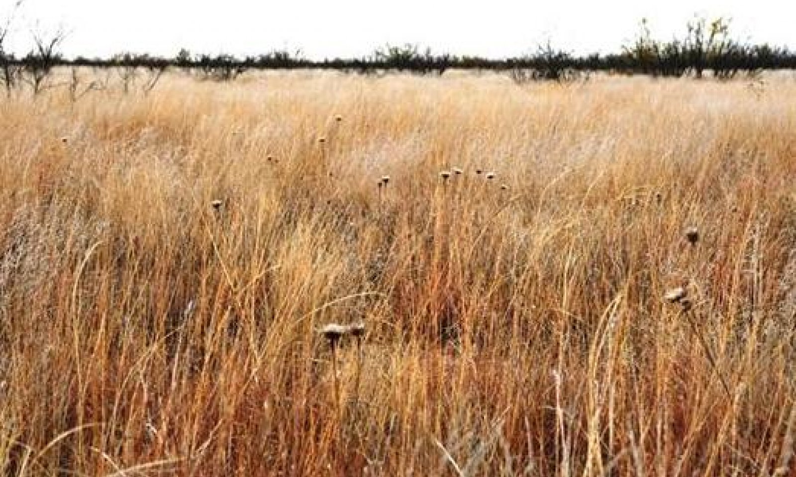
Figure 8. 1.1 Shortgrass/Midgrass Community
The Shortgrass/Midgrass Community (1.1) is the interpretive or "reference" plant community for the Clay Loam Ecological Site. This site developed under a dry, sub-humid climate with hot dry summers. Natural wildfires kept woody plants at a minimum. The plant community’s ecological processes were in balance with the environment.
The primary grass species are blue grama (>30 percent) and buffalograss (>20 percent) with lesser amounts of sideoats grama and sand dropseed. Forbs are minimal, less than 5 percent woody plants occur, primarily catclaw mimosa, lotebush, broom snakeweed and an occasional shrubby mesquite. The total production ranges from 800 to 2,000 pounds per acre annually.
If grazing pressure occurs for long periods combined with lack of fire, the reference community will transition to a Shortgrass/Shrubs Community (1.2). There will be a reduction in midgrass species and an increase in low vigor shortgrasses and shrubs. Grass production still dominates total annual herbage production but the encroaching woody species production has increased somewhat.Figure 9. Annual production by plant type (representative values) or group (midpoint values)
Table 5. Annual production by plant type
Plant type Low
(lb/acre)Representative value
(lb/acre)High
(lb/acre)Grass/Grasslike 750 1330 1850 Shrub/Vine 40 85 130 Forb 10 15 20 Microbiotic Crusts 0 0 0 Tree 0 0 0 Total 800 1430 2000 Figure 10. Plant community growth curve (percent production by month). TX1251 , Warm-season bunchgrasses w/ forbs & shrubs. Warm-season bunchgrasses with forbs and shrubs..
Jan Feb Mar Apr May Jun Jul Aug Sep Oct Nov Dec J F M A M J J A S O N D 0 1 3 5 12 16 15 20 18 9 1 0 Community 1.2
Shortgrass/Shrub Community
Figure 11. 1.2 : Shortgrass/Shrub Community
The Shortgrass/Shrub Community Phase (1.2) is the result of continuous grazing pressure over an extended period of time combined with periodic droughts. With the decline in grass plant biomass and litter, a corresponding reduction in the frequency and intensity of natural fires occurs, resulting in an increase in woody shrubs.
Blue grama and sideoats grama will reach a low vigor state with an increase in perennial and annual forbs. The percentage of bare soil will also increase at this point. Shrubby mesquite will increase to greater than 15 percent canopy. The herbaceous vegetation biomass is still the largest amount of the total site production at this phase, but woody plant production is increasing.
This plant community has not crossed a threshold at this point and can be managed back to the reference community. Nutrient cycling, the water cycle, watershed protection and biological functions have been reduced. The shift back to the reference community is possible with proper grazing management, growing season rest, brush and pest management.
If heavy grazing pressure continues with no possibility of fire, combined with no brush and pest management, this phase of regression will transition into a shrubland state. The result will be a Shrub/Shortgrass/Annuals Community (2.1).
If heavy grazing pressure continues with no possibility of fire, combined with no brush and pest management along with introduced grass invasion of Lehman lovegrass, the Grassland State will transition to the Introduced Grass/Shrubland State (3).Figure 12. Annual production by plant type (representative values) or group (midpoint values)
Table 6. Annual production by plant type
Plant type Low
(lb/acre)Representative value
(lb/acre)High
(lb/acre)Grass/Grasslike 600 1000 1400 Shrub/Vine 100 150 200 Forb 40 80 120 Microbiotic Crusts 0 0 0 Tree 0 0 0 Total 740 1230 1720 Figure 13. Plant community growth curve (percent production by month). TX1252 , Shortgrass Dominant/Invading Shrub Community. Warm-season shortgrasses with increasing shrubs and forbs..
Jan Feb Mar Apr May Jun Jul Aug Sep Oct Nov Dec J F M A M J J A S O N D 0 1 3 5 12 16 15 20 18 9 1 0 Pathway 1.1A
Community 1.1 to 1.2
Shortgrass/Midgrass Community
Shortgrass/Shrub CommunityIf grazing pressure occurs for long periods combined with lack of fire, the reference community(1.1) will transition to a Shortgrass/Shrubs Community (1.2).
Pathway 1.2A
Community 1.2 to 1.1
Shortgrass/Shrub Community
Shortgrass/Midgrass CommunityThis plant community has not crossed a threshold at this point and can be managed back to the reference community. The shift back to the reference community is possible with proper grazing management, growing season rest, brush and pest management.
Conservation practices
Brush Management Integrated Pest Management (IPM) Prescribed Grazing State 2
Shrubland StateIn this degraded Shrubland state, typical vegetation will be less palatable shortgrass species; bare areas will open up with annuals filling the voids. Perennial threeawn will invade this site when the more desirable grasses are weakened and/or removed. Scrubby mesquite and broom snakeweed will increase dramatically to the point of domination. The loss of herbaceous cover and increased bare ground encourages accelerated erosion.
Dominant plant species
-
honey mesquite (Prosopis glandulosa), shrub
-
broom snakeweed (Gutierrezia sarothrae), shrub
-
threeawn (Aristida), grass
Community 2.1
Shrub/Shortgrass/Annuals Community
Figure 14. 2.1 Shrub/Shortgrass/Annuals Community
As retrogression continues from long-term heavy grazing and fire suppression compounded by drought conditions, a threshold will be crossed to a Shrub/Shortgrass/Annuals Community (2.1). In this degraded state, typical vegetation will be less palatable shortgrass species; bare areas will open up with annuals filling the voids. Perennial three-awn will invade this site when the more desirable grasses are weakened and/or removed. Scrubby mesquite and broom snakeweed will increase dramatically to the point of domination. The loss of herbaceous cover and increased bare ground encourages accelerated erosion.
The plant community is so degraded that it cannot reverse retrogression without extensive energy and management inputs. Restoration of this community (2.1) will require prescribed grazing with rest periods during the growing season, re-seeding bare areas with adapted native grass species, and heavy mechanical brush management and some form of pest management. With the reduced amounts of grass fuel, prescribed burning is not an option in this phase.
Figure 15. Annual production by plant type (representative values) or group (midpoint values)
Table 7. Annual production by plant type
Plant type Low
(lb/acre)Representative value
(lb/acre)High
(lb/acre)Shrub/Vine 400 700 900 Grass/Grasslike 320 560 720 Forb 80 140 180 Microbiotic Crusts 0 0 0 Tree 0 0 0 Total 800 1400 1800 Figure 16. Plant community growth curve (percent production by month). TX1254 , Shrub/Shortgrass/Annuals Community. Spring and fall growth of shortgrasses, annuals, and shrubs..
Jan Feb Mar Apr May Jun Jul Aug Sep Oct Nov Dec J F M A M J J A S O N D 0 1 4 6 10 16 15 20 15 12 1 0 State 3
Introduced Grass/Shrubland StateClay Loam sites in a weakened state near established areas of Lehman lovegrass may become invaded by this grass to the point that Lehman lovegrass is the dominant grass species in the community. Few if any native grass and forb species will remain. The resulting plant community is a Lehman Lovegrass/Shrub Community (3.1).
Dominant plant species
-
Lehmann lovegrass (Eragrostis lehmanniana), grass
Community 3.1
Lehman Lovegrass/Shrub Community
Figure 17. 3.1 Lehman Lovegrass/Shrub Community
Clay Loam sites in a weakened state near established areas of Lehman lovegrass may become invaded by this grass to the point that Lehman lovegrass is the dominant grass species in the community. Few if any native grass and forb species will remain. The resulting plant community is a Lehman Lovegrass/Shrub Community (3.1). Once this lovegrass has become well established to the point of naturalization, returning the site to the reference state will be expensive and generally not very successful or practical.
This lovegrass species does provide excellent soil erosion control from wind and water and produces a great deal of plant biomass which aids in improved hydrology of the site. Lehman lovegrass is very drought tolerant and does provide fair to good grazing forage for livestock. But, wildlife benefits are minimal with the reduction in native forbs, browse and cover.
If the objective of the land manager is to restore this site to the reference state, prescribed burning for seedbed preparation purposes may be necessary to remove excessive amounts of plant biomass. Moderate to heavy mechanical brush management, heavy seedbed preparation and re-seeding to a native grass mixture will be required. The application of herbicides can be effective to reduce competition from this lovegrass species, but there is only a narrow time of treatment opportunity.Figure 18. Annual production by plant type (representative values) or group (midpoint values)
Table 8. Annual production by plant type
Plant type Low
(lb/acre)Representative value
(lb/acre)High
(lb/acre)Grass/Grasslike 1000 2000 3000 Shrub/Vine 400 700 900 Forb 10 15 20 Microbiotic Crusts 0 0 0 Tree 0 0 0 Total 1410 2715 3920 Figure 19. Plant community growth curve (percent production by month). TX1255 , Lehman Lovegrass/Shrub Dominant Community. Lehman lovegrass with shrub dominance..
Jan Feb Mar Apr May Jun Jul Aug Sep Oct Nov Dec J F M A M J J A S O N D 0 1 5 8 16 18 12 15 18 6 1 0 Transition T1A
State 1 to 2If heavy grazing pressure continues with no possibility of fire, combined with no brush and pest management, this phase of regression will transition into a shrubland state. The result will be a Shrub/Shortgrass/Annuals Community (2.1).
Restoration pathway R2A
State 2 to 1The plant community is so degraded that it cannot reverse retrogression without extensive energy and management inputs. Restoration of this community (2.1) to the Grassland State (1) will require prescribed grazing with rest periods during the growing season, re-seeding bare areas with adapted native grass species, and heavy mechanical brush management and some form of pest management. With the reduced amounts of grass fuel, prescribed burning is not an option in this phase.
Conservation practices
Brush Management Prescribed Grazing Range Planting Integrated Pest Management (IPM) Transition T2A
State 2 to 3If heavy grazing pressure continues with no possibility of fire, combined with no brush and pest management along with introduced grass invasion of Lehman lovegrass, the Grassland State will transition to the Introduced Grass/Shrubland State (3).
Restoration pathway R3A
State 3 to 2Restoration of this site requires prescribed burning for seedbed preparation purposes may be necessary to remove excessive amounts of plant biomass. Moderate to heavy mechanical brush management, heavy seedbed preparation and re-seeding to a native grass mixture will be required. The application of herbicides can be effective to reduce competition from this lovegrass species, but there is only a narrow time of treatment opportunity. Prescribed grazing and pest management are also required.
Additional community tables
Table 9. Community 1.1 plant community composition
Group Common name Symbol Scientific name Annual production () Foliar cover (%) Grass/Grasslike1 Shortgrasses 400–1000 blue grama BOGR2 Bouteloua gracilis 240–600 – buffalograss BODA2 Bouteloua dactyloides 160–400 – 2 Mid/Shortgrasses 240–600 cane bluestem BOBA3 Bothriochloa barbinodis 40–100 – sideoats grama BOCU Bouteloua curtipendula 40–100 – black grama BOER4 Bouteloua eriopoda 40–100 – Arizona cottontop DICA8 Digitaria californica 40–100 – vine mesquite PAOB Panicum obtusum 40–100 – large-spike bristlegrass SEMA5 Setaria macrostachya 40–100 – 3 Mid/Shortgrasses 40–100 threeawn ARIST Aristida 20–50 – sand dropseed SPCR Sporobolus cryptandrus 20–50 – 4 Shortgrasses 70–150 tobosagrass PLMU3 Pleuraphis mutica 70–150 – Forb5 Forbs 10–20 Forb, annual 2FA Forb, annual 0–5 – Cuman ragweed AMPS Ambrosia psilostachya 0–5 – American star-thistle CEAM2 Centaurea americana 0–5 – croton CROTO Croton 0–5 – beeblossom GAURA Gaura 0–5 – woolly plantain PLPA2 Plantago patagonica 0–5 – stiff greenthread THFI Thelesperma filifolium 0–5 – Shrub/Vine6 Shrubs/Vines 40–130 fourwing saltbush ATCA2 Atriplex canescens 5–20 – broom snakeweed GUSA2 Gutierrezia sarothrae 5–20 – Berlandier's wolfberry LYBE Lycium berlandieri 5–20 – catclaw mimosa MIACB Mimosa aculeaticarpa var. biuncifera 5–20 – honey mesquite PRGL2 Prosopis glandulosa 5–20 – yucca YUCCA Yucca 5–20 – lotebush ZIOB Ziziphus obtusifolia 5–20 – Table 10. Community 1.2 plant community composition
Group Common name Symbol Scientific name Annual production () Foliar cover (%) Table 11. Community 2.1 plant community composition
Group Common name Symbol Scientific name Annual production () Foliar cover (%) Table 12. Community 3.1 plant community composition
Group Common name Symbol Scientific name Annual production () Foliar cover (%) Interpretations
Animal community
Woody plants provide cover for deer and quail. These wildlife species have both increased along with the brushy plants due to the cover that these plants provide. According to most wildlife biologists, both species prefer a lower successional plant community than was present in historic climax. More forbs are needed to meet these species food requirements and woody plants for browse are important for deer. It is often the objective of many land owners to strike a balance in plant community so that these wildlife species can exist along with domestic livestock. This can be accomplished by a carefully thought out grazing and brush management program. It must be realized that managing at a lower successional level may meet some wildlife species requirements very well, but may not be nearly as productive for grazing purposes. Lower successional levels may not be as capable of satisfying functions such as nutrient cycling, hydrologic protection, plant community stability or soil protection. A proper balance can be achieved with careful planning that considers all resources.
Hydrological functions
Hydrologically, the site contributes runoff to the various draws, creeks, and streams that are common in the MLRA. If the perennial grass cover is maintained in good vigor, then maximum infiltration occurs and runoff is reduced. More water getting into the ground means a healthier, more productive plant community. If infiltration is minimal, then the effect is an artificially shallow soil with plant roots retreating to near the soil surface. More perennial grass cover means less runoff may result but the runoff that does occur is less laden with sediment. Overall watershed protection is enhanced by a healthy grassland community, as is nutrient cycling.
Recreational uses
Hunting, Camping, Hiking, Birdwatching, Photography, Horseback Riding
Wood products
None.
Other products
None.
Other information
None.
Supporting information
Inventory data references
NRCS FOTG – Section II of the FOTG Range Site Descriptions and numerous historical accounts of vegetative conditions at the time of early settlement in the area were used in the development of this site description. Vegetative inventories were made at several site locations for support documentation. Inventory Data References (documents): NRCS FOTG – Section II - Range Site Descriptions NRCS Clipping Data summaries over a 20 year period
Other references
J.R. Bell, USDA-NRCS Rangeland Management Specialist (retired)
Natural Resources Conservation Service - Range Site Descriptions
USDA-Natural Resources Conservation Service - Soil Surveys & Website soil database
Rathjen, Frederick W., The Texas Panhandle Frontier, Rev. 1998, Univ. of Texas Press
Hatch, Brown and Ghandi, Vascular Plants of Texas (Ecological Checklist)
Texas A&M Exp. Station, College Station, Texas
Texas Tech University – Range, Wildlife & Fisheries DepartmentContributors
Clint Rollins, RMS, NRCS, Amarillo, Texas
Earl D. Archer
Todd Carr, SS, NRCS, Lubbock, TexasApproval
Bryan Christensen, 9/11/2023
Acknowledgments
J.R. Bell, USDA-NRCS Rangeland Management Specialist (retired) Rathjen, Frederick W., The Texas Panhandle Frontier, Rev. 1998, Univ. of Texas Press
Rangeland health reference sheet
Interpreting Indicators of Rangeland Health is a qualitative assessment protocol used to determine ecosystem condition based on benchmark characteristics described in the Reference Sheet. A suite of 17 (or more) indicators are typically considered in an assessment. The ecological site(s) representative of an assessment location must be known prior to applying the protocol and must be verified based on soils and climate. Current plant community cannot be used to identify the ecological site.
Author(s)/participant(s) Stan Bradbury, Zone RMS, NRCS, Lubbock, Texas Contact for lead author 806-791-0581 Date 09/04/2007 Approved by Approval date Composition (Indicators 10 and 12) based on Annual Production Indicators
-
Number and extent of rills:
None to slight. -
Presence of water flow patterns:
None to slight. -
Number and height of erosional pedestals or terracettes:
None to slight. -
Bare ground from Ecological Site Description or other studies (rock, litter, lichen, moss, plant canopy are not bare ground):
25-30% bare ground. -
Number of gullies and erosion associated with gullies:
None to slight. -
Extent of wind scoured, blowouts and/or depositional areas:
None to slight. -
Amount of litter movement (describe size and distance expected to travel):
None to slight. -
Soil surface (top few mm) resistance to erosion (stability values are averages - most sites will show a range of values):
Slight to moderate water surface erosion. -
Soil surface structure and SOM content (include type of structure and A-horizon color and thickness):
Loam to clay loam; friable surface; high SOM. -
Effect of community phase composition (relative proportion of different functional groups) and spatial distribution on infiltration and runoff:
Basal cover and density with small interspaces should make rainfall impact minimal. This site has moderately slow permeable soil; runoff is slow to medium; and available water holding capacity is high. -
Presence and thickness of compaction layer (usually none; describe soil profile features which may be mistaken for compaction on this site):
None. -
Functional/Structural Groups (list in order of descending dominance by above-ground annual-production or live foliar cover using symbols: >>, >, = to indicate much greater than, greater than, and equal to):
Dominant:
Warm-season shortgrasses >>Sub-dominant:
Warm-season midgrasses > Cool-season midgrasses >Other:
Forbs > Shrubs/VinesAdditional:
-
Amount of plant mortality and decadence (include which functional groups are expected to show mortality or decadence):
Grasses due to their growth habit will exhibit some mortality and decadence, though minimal. -
Average percent litter cover (%) and depth ( in):
Litter is dominantly herbaceous. -
Expected annual annual-production (this is TOTAL above-ground annual-production, not just forage annual-production):
800 to 2,000 pounds per acre. -
Potential invasive (including noxious) species (native and non-native). List species which BOTH characterize degraded states and have the potential to become a dominant or co-dominant species on the ecological site if their future establishment and growth is not actively controlled by management interventions. Species that become dominant for only one to several years (e.g., short-term response to drought or wildfire) are not invasive plants. Note that unlike other indicators, we are describing what is NOT expected in the reference state for the ecological site:
Mesquite, pricklypear, yucca and broom snakeweed can become invasive. -
Perennial plant reproductive capability:
All plant species should be capable of reproduction except during periods of prolonged drought conditions, heavy natural herbivory or intense wildfires.
Print Options
Sections
Font
AAAAOther
PrintThe Ecosystem Dynamics Interpretive Tool is an information system framework developed by the USDA-ARS Jornada Experimental Range, USDA Natural Resources Conservation Service, and New Mexico State University.
Accessibility statement


