
Natural Resources
Conservation Service
Ecological site R077AY015KS
Loamy Upland
16-22" PZ
Last updated: 9/11/2023
Accessed: 09/15/2026
-
Search


Major Land Resource Area or ecological site by name and/or ID.
PreviousSectionsNextGeneral information
Provisional. A provisional ecological site description has undergone quality control and quality assurance review. It contains a working state and transition model and enough information to identify the ecological site.
Click to explore map
Figure 1. Mapped extent
Areas shown in blue indicate the maximum mapped extent of this ecological site. Other ecological sites likely occur within the highlighted areas. It is also possible for this ecological site to occur outside of highlighted areas if detailed soil survey has not been completed or recently updated.
MLRA notes
Major Land Resource Area (MLRA): 077A–Southern High Plains, Northern Part
MLRA 77A is characterized by nearly level plains with playa depressions and sloping
breaks along rivers and creeks. Soils are generally deep, fine-textured, and occur in a
mesic soil temperature regime.Classification relationships
This ecological site is correlated to soil components at the Major Land Resource Area (MLRA) level which is further described in USDA Ag Handbook 296.
Ecological site concept
These sites occur on soils with loam or silt loam surfaces and fine-silty or fine-loamy subsoils on uplands. Reference vegetation consists of native mid- and tallgrass species with forbs and very few woody species. This plant community evolved under periodic fire, grazing, and drought. Abusive grazing may lead to a decline in the more palatable tallgrasses and exclusion of fire can allow woody species to increase on the site.
Associated sites
R077AY001TX Deep Hardland 16-22" PZ
Nearly level to gently sloping fine-textured soils on adjacent positions that formed in calcareous loess. Dominated by short and mid-grass species with few woody species.
R077AY004OK Parna Dune 16-22" PZ
Gently to moderately sloping silty and loamy soils formed in calcareous parna on higher adjacent dune positions. Dominated by mid- and shortgrass species with very few woody species.
R077AY005TX Playa 16-22" PZ
Nearly level clayey soils with high shrink-swell potential on lower closed depression playa positions that intermittently pond water. Vegetation is variable and includes hydrophytes.
R077AY002TX Draw 16-22" PZ
Gently sloping loamy soils on lower positions that receive water run-on from adjacent sites. Due to increased water availability this site has higher production potential with tall and mid grasses.
Similar sites
R077EY056OK Loamy Upland 16-24" PZ
A similar site in MLRA 77E with soils formed from recent alluvium in a slightly warmer thermic soil temperature regime.
R077AY012TX Sandy Loam 16-22" PZ
Nearly level to gently sloping soils with sandy loam or fine sandy loam surfaces and fine-loamy argillic horizons formed on low dunes and sand sheets on adjacent positions. Midgrass and shortgrass dominant with few woody shrubs.
Table 1. Dominant plant species
Tree Not specified
Shrub Not specified
Herbaceous (1) Panicum virgatum
(2) Andropogon halliiPhysiographic features
These sites are on level to gently sloping plains and interdunes of the Southern High Plains.
Table 2. Representative physiographic features
Landforms (1) Plains > Plain
(2) Plains > Interdune
(3) Plains > Sand sheet
Runoff class Negligible to low Flooding frequency None Ponding frequency None Elevation 2500 – 4500 ft Slope 0 – 3 % Aspect Aspect is not a significant factor Table 3. Representative physiographic features (actual ranges)
Runoff class Negligible to low Flooding frequency None Ponding frequency None Elevation 2300 – 4990 ft Slope 0 – 5 % Climatic features
Climate is a cold semi-arid steppe (Koppen-Geiger classification BSk). Summers are hot and winters are cold. Temperature extremes are common. Humidity is generally low, and short-term droughts are common. Humidity is generally low and evaporation high. Average annual wind speed is 12 mph with highest winds in early spring. The prevailing wind direction is south. Summertime brings strong high pressure systems that build into heat domes with highs in the upper 90 to mid-100 degree F range. Evaporation in summer is high and open pan evaporation exceeds 6 feet per year. Early autumn temperatures are mild, with Canadian and Pacific cold fronts bringing cold air in mid-autumn throughout winter. Arctic air can settle in and dominate for several weeks during winter with very cold air in place for 2 to 3 weeks at a time.
Most of the precipitation comes in the form of rain from May through September. Rainfall events often occur as intense showers of relatively short duration. Snowfall average is about 15 inches but is also variable from 8 to 36 inches annually. Long term droughts are likely to occur every 15 to 20 years and may last 4 to 5 years. Mean precipitation is around 19 inches but varies significantly from year to year. Rainfall amounts over the last 100 years have varied from as little as 9 inches to as much as 37 inches. The probability is about 70% that precipitation will fall between 14 inches and 23 inches. Growing season averages 180 days. Average first frost is around October 17, and the last freeze of the season occurs around April 21.Table 4 Representative climatic features
Frost-free period (characteristic range) 140-160 days Freeze-free period (characteristic range) 180-190 days Precipitation total (characteristic range) 20-20 in Frost-free period (actual range) 140-160 days Freeze-free period (actual range) 170-190 days Precipitation total (actual range) 20-20 in Frost-free period (average) 150 days Freeze-free period (average) 180 days Precipitation total (average) 20 in Characteristic rangeActual rangeBarLineFigure 2. Monthly precipitation range
Characteristic rangeActual rangeBarLineFigure 3. Monthly minimum temperature range
Characteristic rangeActual rangeBarLineFigure 4. Monthly maximum temperature range
BarLineFigure 5. Monthly average minimum and maximum temperature
Figure 6. Annual precipitation pattern
Figure 7 Annual average temperature pattern
Climate stations used
-
(1) ELKHART [USC00142432], Elkhart, KS
-
(2) BOISE CITY 2 E [USC00340908], Boise City, OK
-
(3) PERRYTON [USC00416950], Perryton, TX
-
(4) HUGOTON [USC00143855], Hugoton, KS
-
(5) LIBERAL [USC00144695], Liberal, KS
-
(6) STRATFORD [USC00418692], Stratford, TX
-
(7) GOODWELL 2 E [USW00003055], Goodwell, OK
-
(8) SPEARMAN [USC00418523], Spearman, TX
-
(9) DUMAS [USC00412617], Dumas, TX
">Influencing water features
Well drained soils with negligible to low runoff. No influencing water features.
Wetland description
Soils in this ecological site are not part of wetland ecosystems.
Soil features
Soils are mapped for each county within the MLRA. Mapunits are representations of the major soil series component(s) and named accordingly. Each Mapunit is spatially represented on a digital soils map as polygons of different shapes and sizes. Within these Mapunits, there are often minor soil series components included. These minor components are soils that occur within a Mapunit polygon but are of small extent (15% or less of the Mapunit area). However, it is difficult to separate these minor soils spatially due to the scale of soil mapping.
Ecological sites are correlated at the component level of the soil survey. Therefore, a single Mapunit may contain multiple Ecological Sites just as it may contain multiple soil components. This is important to understand when investigating soils and Ecological Sites. A soil survey Mapunit may be correlated to a single Ecological Site based on the major component; however, there may be inclusions of areas of additional Ecological Sites which are correlated to the minor components of that particular soil Mapunit.
This group of soils consists of very deep, well drained, and moderately permeable soils that formed in silty, calcareous, loess and loamy eolian deposits. These soils occur on loess plains, sandsheets, and interdunes. They have loam or silt loam surface textures, fine-silty or fine-loamy argillic horizons, and some have a calcic horizon below 100 cm (40 in) of the soil surface. Slopes range from 0 to 5 percent. Runoff is negligible to low dependent upon the slope.
Representative soil components for this site include: Belfon loam, Forgan, and Hugoton.Table 5. Representative soil features
Parent material (1) Calcareous loess
(2) Eolian deposits
Surface texture (1) Loam
(2) Silt loam
Family particle size (1) Fine-loamy
(2) Fine-silty
Drainage class Well drained Permeability class Moderate Soil depth 80 in Surface fragment cover <=3" Not specified Surface fragment cover >3" Not specified Available water capacity
(0-40in)5.2 – 8.1 in Calcium carbonate equivalent
(0-40in)0 – 10 % Electrical conductivity
(0-40in)0 – 1 mmhos/cm Sodium adsorption ratio
(0-40in)Not specified Soil reaction (1:1 water)
(0-40in)6.6 – 7.8 Subsurface fragment volume <=3"
(0-40in)0 – 1 % Subsurface fragment volume >3"
(0-40in)Not specified Ecological dynamics
The information contained in the State and Transition Diagram (STD) and the Ecological Site Description was developed using archeological and historical data, professional experience, and scientific studies. The information presented is representative of a very complex set of plant communities. Not all scenarios or plants are included. Key indicator plants, animals and ecological processes are described to inform land management decisions.
Like many ecosites throughout the great plains, the Loamy Upland site evolved under periodic fire and grazing events. The deep loamy soils support the growth of palatable vegetation for grazing and browsing animals. In the reference condition this vegetation is also capable of carrying fires across the landscape which, historically, has limited the encroachment of woody species. The deep rooted tallgrass species and good ground cover facilitated capture and infiltration of precipitation.
However, these productive soils were often overutilized by cattlemen or plowed up by the farmsteaders in the early 1900s. This lead to widespread erosion in some areas and depletion of the soil resources. While farming has ceased on many of these upland sites, abusive grazing practices still persist. Most acres that were farmed have been planted back to introduced species such as old world bluestems, irrigated bermudagrass, or in some cases native species. While the monocultures of introduced species can address the soil erosion on these sites, they do little to restore the hydrologic or ecological function.
In the absence of prescribed fire or alternative brush management, woody species are likely to increase in abundance and stature. While these woody species may not increase enough to dominate ecological functions on the site, their presence can negatively impact grazing access and prairie wildlife habitat.
Due to the increase in precipitation across the MLRA from west to east, the production by species may vary.
State and Transition Diagram:
A State and Transition Diagram for the Loamy Upland (R077AY015KS) site is depicted below. Thorough descriptions of each state, transition, and pathway follow the model. Experts base this model on available experimental research, field observations, professional consensus, and interpretations. It is likely to change as knowledge increases.
Plant communities will differ across the MLRA because of the natural variability in weather, soils, and aspect. The Reference Plant Community is not necessarily the management goal; other vegetative states may be desired plant communities as long as the Range Health assessments are in the moderate and above category.
The biological processes on this site are complex. Therefore, representative values are presented in a land management context. The species lists are representative and are not botanical descriptions of all species occurring, or potentially occurring, on this site. They are not intended to cover every situation or the full range of conditions, species, and responses for the site.
The following diagram suggests some pathways that the vegetation on this site might take. There may be other states not shown on the diagram. This information is intended to show what might happen in a given set of circumstances. It does not mean that this would happen the same way in every instance. Local professional guidance should always be sought before pursuing a treatment scenario.State and transition model
More interactive model formats are also available. View Interactive Models
Click on state and transition labels to scroll to the respective textEcosystem states
T1A - Extensive soil disturbance followed by seeding T2A - Prolonged extensive soil disturbance and loss of site stability State 1 submodel, plant communities
State 1
Grassland (R)This is the reference ecological state for the site. The description is based on early range site descriptions, clipping data, professional consensus of experienced range specialists, and analysis of any field work.
Dominant plant species
-
little bluestem (Schizachyrium scoparium), grass
-
switchgrass (Panicum virgatum), grass
Community 1.1
Tall/Midgrass
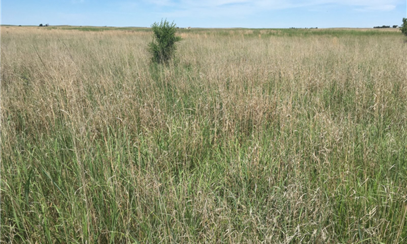
Figure 8. Loamy Upland, Beaver County, OK
This is the reference community for the Loamy Upland site. The vegetation is dominated by mixed tallgrasses and midgrasses, mainly sand and little Bluestem and switchgrass. Sideoats grama may be abundant along with many perennial forbs and legumes. Minor amounts of woody species may occur including skunkbush, hackberry, or sandplum. Total annual production for this community is estimated to range from 1500 to 3000 pounds per acre.
Community 1.2
Mid/shortgrassThis plant community is dominated by mid and shortgrasses such as sideoats grama and blue grama. Other species may include dropseed species, silver bluestem and some remnant little bluestem. There has been an increase in annual forbs and bare ground. With the absence of tallgrasses, the forage base for grazing livestock has been diminished and infiltration rate may have declined also.
Community 1.3
Woody EncroahmentThis community phase has been encroached upon by woody species such as junipers, Siberian elm, or others. While the woody species may not expand enough to dominate the hydrologic or energy flow across the site, this is still an important community shift to identify. Particularly from a wildlife habitat standpoint.
Pathway 1.1A
Community 1.1 to 1.2Abusive grazing practices that include stocking above carry capacity without adequate rest may push this community towards community 1.2 as the more palatable species are damaged. Additionally, long periods of drought may hinder the vigor of some of the tallgrasses and favor the more drought tolerant mid and short grasses.
Pathway 1.1B
Community 1.1 to 1.3In the absence of prescribed fire or alternative brush management, woody species may encroach on the site pushing it to community 1.3.
Pathway 1.2A
Community 1.2 to 1.1Through adequate rest from grazing and favorable growing season precipitation, this community may be shifted back to the reference community.
Pathway 1.2B
Community 1.2 to 1.3In the absence of prescribed fire or alternative brush management, woody species may encroach on the site pushing it to community 1.3.
Pathway 1.3A
Community 1.3 to 1.1Through the implementation of a prescribed fire or brush management program, coupled with prescribed grazing, this community may be shifted back to the reference community.
Pathway 1.3B
Community 1.3 to 1.2Through the implementation of a prescribed fire or a brush management program without prescribed grazing, this community may be shifted to community phase 1.2.
State 2
Land Use ConversionThis is an alternative state from the reference. Hydrologic and ecological functions have been altered. This site is in current crop production or has been tilled and seeded to an introduced forage. The soil structure and biology has been altered and requires different management. See Soil Survey or Extension publications for yield data.
State 3
ErodedThis is an alternative state from the reference. Hydrologic and ecological functions have been altered. This state is the result of water erosion over bare soil. Much of the "A" horizon of the soil profile has been displaced. The remaining subsoil is very low in fertility. Some native grasses and forbs will persist in this state, however, production is greatly reduced.
Transition T1A
State 1 to 2Through tillage and seeding this site will transition to state 2.
Transition T2A
State 2 to 3Cultivation of these sites has often lead to severe water and wind erosion. As the soils "A" horizon is displaced, the site will transition to the eroded state.
Constraints to recovery.Prolonged extensive soil disturbance and loss of site stability
Additional community tables
Table 6. Community 1.1 plant community composition
Group Common name Symbol Scientific name Annual production () Foliar cover (%) Table 7. Community 1.2 plant community composition
Group Common name Symbol Scientific name Annual production () Foliar cover (%) Table 8. Community 1.3 plant community composition
Group Common name Symbol Scientific name Annual production () Foliar cover (%) Interpretations
Animal community
The animal species that utilize this site as habitat are mainly small mammals, song birds, and traditional game species like bobwhite and scaled quail, mule deer, pronghorn antelope and lesser prairie chicken. The combination of grasses, forbs and woody shrubs that occur in the plant community provide suitable habitat for all the above species, at least at some time during the year. Predators such as coyotes and bobcats may utilize the site for hunting prey and to hide during the day. If the site is a shrub dominant community, then diversity is decreased and the wildlife habitat will usually be less desirable.
Supporting information
Inventory data references
Old range site descriptions, condition class worksheets, and soil survey manuscripts were used in the development of this provisional ESD.
Other references
USDA-NRCS (Formerly Soil Conservation Service) Range Site Descriptions (1960s)
USDA-NRCS (Formerly Soil Conservation Service) Ag Handbook 296 (2006)Contributors
Colin Walden Range Specialist Stillwater OK
Steven McGowen, MLRA Office Leader, NRCS, Woodward, OKApproval
Bryan Christensen, 9/11/2023
Acknowledgments
Site Development and Testing Plan Future work, as described in a Project Plan, to validate the information in this Provisional Ecological Site Description is needed. This will include field activities to collect low, medium and high intensity sampling, soil correlations, and analysis of that data. Annual field reviews should be done by soil scientists and vegetation specialists. A final field review, peer review, quality control, and quality assurance reviews of the ESD will be needed to produce the final document. Annual reviews of the Project Plan are to be conducted by the Ecological Site Technical Team.
Rangeland health reference sheet
Interpreting Indicators of Rangeland Health is a qualitative assessment protocol used to determine ecosystem condition based on benchmark characteristics described in the Reference Sheet. A suite of 17 (or more) indicators are typically considered in an assessment. The ecological site(s) representative of an assessment location must be known prior to applying the protocol and must be verified based on soils and climate. Current plant community cannot be used to identify the ecological site.
Author(s)/participant(s) Contact for lead author Date 09/15/2026 Approved by Approval date Composition (Indicators 10 and 12) based on Annual Production Indicators
-
Number and extent of rills:
-
Presence of water flow patterns:
-
Number and height of erosional pedestals or terracettes:
-
Bare ground from Ecological Site Description or other studies (rock, litter, lichen, moss, plant canopy are not bare ground):
-
Number of gullies and erosion associated with gullies:
-
Extent of wind scoured, blowouts and/or depositional areas:
-
Amount of litter movement (describe size and distance expected to travel):
-
Soil surface (top few mm) resistance to erosion (stability values are averages - most sites will show a range of values):
-
Soil surface structure and SOM content (include type of structure and A-horizon color and thickness):
-
Effect of community phase composition (relative proportion of different functional groups) and spatial distribution on infiltration and runoff:
-
Presence and thickness of compaction layer (usually none; describe soil profile features which may be mistaken for compaction on this site):
-
Functional/Structural Groups (list in order of descending dominance by above-ground annual-production or live foliar cover using symbols: >>, >, = to indicate much greater than, greater than, and equal to):
Dominant:
Sub-dominant:
Other:
Additional:
-
Amount of plant mortality and decadence (include which functional groups are expected to show mortality or decadence):
-
Average percent litter cover (%) and depth ( in):
-
Expected annual annual-production (this is TOTAL above-ground annual-production, not just forage annual-production):
-
Potential invasive (including noxious) species (native and non-native). List species which BOTH characterize degraded states and have the potential to become a dominant or co-dominant species on the ecological site if their future establishment and growth is not actively controlled by management interventions. Species that become dominant for only one to several years (e.g., short-term response to drought or wildfire) are not invasive plants. Note that unlike other indicators, we are describing what is NOT expected in the reference state for the ecological site:
-
Perennial plant reproductive capability:
Print Options
Sections
Font
AAAAOther
PrintThe Ecosystem Dynamics Interpretive Tool is an information system framework developed by the USDA-ARS Jornada Experimental Range, USDA Natural Resources Conservation Service, and New Mexico State University.
Accessibility statement


