
Natural Resources
Conservation Service
-
Search


Major Land Resource Area or ecological site by name and/or ID.
PreviousSectionsNextGeneral information
Approved. An approved ecological site description has undergone quality control and quality assurance review. It contains a working state and transition model, enough information to identify the ecological site, and full documentation for all ecosystem states contained in the state and transition model.
Click to explore map
Figure 1. Mapped extent
Areas shown in blue indicate the maximum mapped extent of this ecological site. Other ecological sites likely occur within the highlighted areas. It is also possible for this ecological site to occur outside of highlighted areas if detailed soil survey has not been completed or recently updated.
MLRA notes
Major Land Resource Area (MLRA): 072X–Central High Tableland
Major Land Resource Area (MLRA) 72--Central High Tableland. This area is in Kansas (54 percent), Nebraska (25 percent), and Colorado (21 percent). A very small part of the area is in Wyoming. The area makes up about 34,550 square miles (89,535 square kilometers). It includes the towns of Garden City, Goodland, and Colby, Kansas; Imperial, North Platte, Ogallala, and Sidney, Nebraska; and Holyoke and Wray, Colorado. Interstate 70 bisects the area, and Interstates 76 and 80 follow the south side of the South and North Platte Rivers, respectively. The Cimarron National Grasslands occur in the southwest corner of the MLRA.
Classification relationships
MLRA 72 is in the Central Great Plains Winter Wheat and Range Land Resource Region. It is in the High Plains Section, of the Great Plains Province, of the Interior Plains (USDA, 2006). MLRAs can be defined by climate, landscapes, geology, and annual precipitation zones (PZ). Other features such as landforms, soil properties, and key vegetation further refine these concepts, and are described at the Ecological Site Description (ESD) level.
Relationship to Other Classifications:
Natural Resource Conservation Service (NRCS) Classification Hierarchy:
Physiographic Division Physiographic Province Physiographic Section Land Resource Region Major Land Resource Area Land Resource Unit (Fenneman, 1946)
United States Forest Service (USFS) Classification Hierarchy:
Domain Division Province Section Subsection Landtype Association Landtype Landtype Phase (Cleland et al, 1997)
REVISION NOTES:
The Chalk Fans site was developed by an earlier version of the Chalk Fans (2018). The earlier version of the Chalk Fans ESD was based upon input from NRCS (formerly Soil Conservation Service) and historical information obtained from the Chalk Flats (CF) Range Site Description (1967, updated1983).Ecological site concept
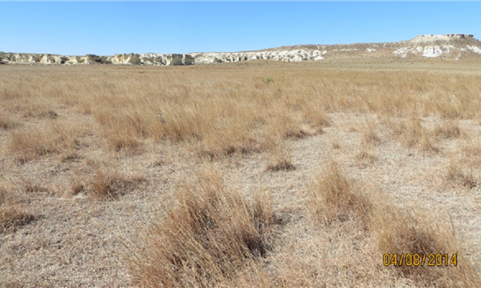
The Chalk Fans ecological site name replaces Chalk Flats due to a change in landform position description usage. This site occurs on nearly level to gently sloping alluvial fans, fan aprons, and colluvial aprons below raw exposures of Niobrara Chalk formation. This site is dominated by calcareous slope alluvium and residuum weathered from chalk, shale and soft limestone. The majority of this site is adjacent to the Smoky Hill River, in Logan and Gove counties, with few acres in Lane and Trego counties in Kansas. Badlands or Outcrop areas that are characterized by steep slopes and lack of vegetative cover are associated with this ecological site.
Associated sites
R072XY101KS Limy Slopes
The Limy Slopes ecological site is located on shoulders and backslopes on hillslopes on tableland landscapes. Soils that are correlated to Limy Slopes have free carbonates occurring within 4 inches (10cm) of the surface. This site is dominated by loess parent material. Limy Slopes generally occurs above this site on the uplands.
Similar sites
R072XY101KS Limy Slopes
The Limy Slopes ecological site is located on shoulders and backslopes on hillslopes on tableland landscapes. Soils that are correlated to Limy Slopes have free carbonates occurring within 4 inches (10cm) of the surface. This site is dominated by loess parent material.
R072XY112KS Shallow Limy
This site occurs on the breaks landscape and characterized by soils that are less than 20 inches to bedrock. The breaks landscape is the area between the tableland and river valleys highlighted by cliff faces. The Shallow Limy ecological site occurs on nearly level to steeply sloping uplands. Much of the site is steep and characterized by rock ledges forming vertical drops.
Table 1. Dominant plant species
Tree Not specified
Shrub Not specified
Herbaceous (1) Schizachyrium scoparium
(2) Bouteloua curtipendulaPhysiographic features
The Chalk Fans ecological site occurs on nearly level to gently sloping alluvial fans, fan aprons, and colluvial aprons below raw exposures of Niobrara Chalk formation. This site is dominated by calcareous slope alluvium and residuum weathered from chalk, shale and soft limestone. This site consists of deep to very deep, strongly calcareous soils, with silty or loamy surface layers and subsoils over soft chalky bedrock. This site receives water from adjacent sites on plains and rises. This site is subject to erosion by wind and water if the vegetative cover is reduced or absent by such things as overgrazing and fire events. Elevation for this site ranges from 2,470 to 3,350 feet.

Figure 2. MLRA72 ESD block diagram
Table 2. Representative physiographic features
Landforms (1) Alluvial fan
(2) Fan apron
Flooding frequency None Ponding frequency None Elevation 2470 – 3350 ft Slope 1 – 10 % Ponding depth 0 in Water table depth 79 – 0 in Climatic features
The climate moisture regime of this region is mostly semiarid. Although a 30-year average of four weather stations (1981-2010), showed ranges of precipitation from 14-25 inches. Large daily and annual variations in temperature are common. Winters are cold because of frequent polar air masses moving into the area from the north from December into March. Summer temperatures are warm and usually prevail for about six months of the year. July typically has the most rainfall, and January is the driest. Most of the rainfall occurs as high-intensity, convective thunderstorms. The annual snowfall averages 16 to 35 inches. Drought occurs an average of three times in a 30-year period (1981-2010).
The climate data listed in the tables below represents minimum and maximum averages and ranges for the climate stations located within the geographic boundaries of Chalk Fans. The dates referenced are from 1981-2010 (latest 30-year average). All weather data is supported by the National Oceanic and Atmospheric Administration (NOAA) 1981-2010 Climate Normals. For the average annual precipitation of individual climate station locations and additional climate data, access the National Water and Climate Center at http://www.wcc.nrcs.usda.govTable 3 Representative climatic features
Frost-free period (characteristic range) 130-140 days Freeze-free period (characteristic range) 150-170 days Precipitation total (characteristic range) 20-20 in Frost-free period (actual range) 130-140 days Freeze-free period (actual range) 140-170 days Precipitation total (actual range) 20-20 in Frost-free period (average) 130 days Freeze-free period (average) 160 days Precipitation total (average) 20 in Characteristic rangeActual rangeBarLineFigure 3. Monthly precipitation range
Characteristic rangeActual rangeBarLineFigure 4. Monthly minimum temperature range
Characteristic rangeActual rangeBarLineFigure 5. Monthly maximum temperature range
BarLineFigure 6. Monthly average minimum and maximum temperature
Figure 7. Annual precipitation pattern
Figure 8 Annual average temperature pattern
Climate stations used
-
(1) RUSSELL SPRINGS [USC00147049], Winona, KS
-
(2) RUSSELL SPRINGS 3N [USC00147050], Winona, KS
-
(3) QUINTER [USC00146637], Quinter, KS
-
(4) HEALY [USC00143554], Healy, KS
">Influencing water features
This site does not have a plant community that is influenced by water or water table from a wetland or stream.<br />
<br />
There are water influencing features within the soil properties. According to field observations and an article by Linnell, 1961 "Where little bluestem was dominant, infiltration was considerably higher than where side-oats grama was dominant, primarily because of partially weathered chalk-rock fragments in the soil supporting little bluestem".
Figure 9. Fig.7-1 from National Range and Pasture Handbook
Soil features
The Chalk Fans ecological site consists of deep to very deep, well drained, moderately slow permeable soils on alluvial fans, and fan aprons. Slopes are nearly level to gently sloping. Runoff is negligible to low. These soils have a silty surface with weak structure and are generally 3 inches thick over Fine-silty subsoil.
The major soils that characterize this site are Manvel and Minnequa.
These attributes represent 0-40 inches in depth or to the first restrictive layer.Table 4. Representative soil features
Parent material (1) Slope alluvium – chalk
(2) Residuum – limestone
Surface texture (1) Silt loam
(2) Loam
Family particle size (1) Loamy
Drainage class Well drained Permeability class Moderately slow to moderate Soil depth 40 – 80 in Surface fragment cover <=3" 0 – 6 % Surface fragment cover >3" 0 – 1 % Available water capacity
(0-40in)2.2 – 9.36 in Calcium carbonate equivalent
(0-40in)0 – 25 % Electrical conductivity
(0-40in)0 – 4 mmhos/cm Sodium adsorption ratio
(0-40in)0 – 15 Soil reaction (1:1 water)
(0-40in)7.4 – 9 Subsurface fragment volume <=3"
(Depth not specified)0 – 18 % Subsurface fragment volume >3"
(Depth not specified)0 – 3 % Ecological dynamics
The plant communities for this site are dynamic due to the complex interaction of many ecological processes. The interpretive plant community for this site is the Reference Plant Community. The Reference Community has been determined by the study of rangeland relic areas, areas protected from excessive disturbance, areas under long term rotational grazing strategies, literature of plant communities from the early 1900s, and local expertise. Trends in plant community dynamics ranging from heavily grazed to lightly grazed areas, seasonal use pastures, and historical accounts have also been used.
This ecological site is made up of a Grassland State. The Grassland State is characterized by non-broken land (no tillage), warm-season tall, mid and shortgrasses, bunchgrasses and sod-forming grasses, forbs, and shrubs.
This site developed with occasional fires as part of the ecological processes. Historically, it is believed that the fires were infrequent, randomly distributed, and started by lightning at various times throughout the season when thunderstorms were likely to occur. It is also believed that pre-European inhabitants may have used fire as a management tool for attracting herds of large migratory herbivores (bison, elk, deer, and pronghorn). The impact of fire over the past 100 years has been relatively insignificant due to the human control of wildfires and the lack of acceptance of prescribed fire as a management tool in the semi-arid, High Plains area.
The degree of herbivory (feeding on herbaceous plants) has a significant impact on the dynamics of the site. Historically, periodic grazing by herds of large migratory herbivores was a primary influence. Secondary influences of herbivory by species such as prairie dogs, grasshoppers, gophers, and root-feeding organisms impacted the vegetation historically, and continue to this day.
The management of herbivory by humans through grazing of domestic livestock and/or manipulation of wildlife populations has been a major influence on the ecological dynamics of the site. This management coupled with the High Plains climate largely dictates the plant communities for the site.
Drought cycles were part of the natural range of variability within the site and have historically had a major impact upon the vegetation. The species composition changes according to the duration and severity of the drought cycle (Albertson and Weaver 1946).
The vegetation on this site is impacted by topography. The percent (steepness) and aspect of the slope interact with other ecological processes to further influence the vegetative dynamics of the site.
Most of this site occurs in the valleys of Hackberry Creek in Gove County and the Smoky Hill River of Gove, Logan, Lane, and Trego counties. This site is preferred for grazing and is more productive and accessible than much of the surrounding area. The flatter, larger areas of this site are preferred by livestock, which can lead to grazing distribution problems. Water locations, salt placement, and other aids help distribute grazing. Other management techniques such as concentrated grazing and/or rotational grazing systems also help distribute grazing more evenly.
The general response of this site to long term continuous grazing pressure is to gradually lose the vigor and reproductive potential of the tall and mid-grass species and shift the plant community toward mid and short grass species.
The tall and midgrass species generally escape excessive grazing pressure on the less accessible areas of the rangeland. The tall and midgrasses maintained in these areas help provide a source for these species to repopulate the site after long periods of drought and/or overgrazing. The use of grazing management that includes needed distribution tools, proper stocking, and adequate recovery periods during the growing season, helps restore this site to its productive potential.
The following diagram illustrates pathways that the vegetation on this site may take from the Reference Plant Community as influencing ecological factors change. There may be other states or plant communities not shown in the diagram as well as noticeable variations within those illustrated and described in the following sections.State and transition model
More interactive model formats are also available. View Interactive Models
Click on state and transition labels to scroll to the respective textEcosystem states
State 1 submodel, plant communities
State 1
Grassland StateThe Grassland State is supported by empirical data, historical data, local expertise, and photographs. This state is defined by two native plant communities that are a result of periodic fire, drought, and grazing. These events are part of the natural disturbance regime and climatic process. The Reference Plant Community consist of warm season sod and bunchgrasses, cool season sod forming grasses, forbs, and shrubs. The Midgrass-shortgrass Plant Community is primarily warm-season midgrass, short grasses, with decreasing amounts of forbs.
Community 1.1
Reference community
Figure 10. Manvel series, Gove County, Tecklenburg photographer

Figure 11. Minnequa series, Logan County, Tecklenburg photographer

Figure 12. Manvel series, Gove County, Tecklenburg photographer
The Reference Community is supported by empirical data, historical data, local expertise, and photographs. The potential vegetation is a mixed grass prairie consisting of approximately 90 percent grasses and grass-like plants, 10 percent forbs, and a trace amount of woody plants. Little bluestem, sideoats grama, and big bluestem are the primary grasses in this community. Secondary species include blue grama, buffalograss, switchgrass, inland saltgrass, and western wheatgrass. Big bluestem and switchgrass are most likely to be present in the areas of this site located in a receiving position for rainfall events. This community has a small forb population. Shrubs will include fourwing saltbush and winterfat.
Little bluestem and sideoats are considered primary mid-grass species in this plant community.
This plant community is productive. Litter is uniformly distributed with very little movement off-site and natural plant mortality is very low. This community is resistant to many disturbances except for extreme, long term, continuous grazing.
Total annual production ranges from 1,500 to 3,000 pounds of air-dried vegetation per acre per year and will average 2,200 pounds. These production figures are the fluctuations expected during favorable, normal, and unfavorable years due to the timing and amount of precipitation and temperature. Total annual production should not be confused with species productivity, which is annual production and variability by species throughout the extent of the community phase.Dominant plant species
-
little bluestem (Schizachyrium scoparium), grass
-
sideoats grama (Bouteloua curtipendula), grass
-
big bluestem (Andropogon gerardii), grass
Figure 13. Annual production by plant type (representative values) or group (midpoint values)
Table 5. Annual production by plant type
Plant type Low
(lb/acre)Representative value
(lb/acre)High
(lb/acre)Grass/Grasslike 1340 1960 2670 Forb 150 220 300 Shrub/Vine 10 20 30 Total 1500 2200 3000 Figure 14. Plant community growth curve (percent production by month). KS1572 , Little Bluestem, Sideoats Grama, w/some Big Bluestem.
Jan Feb Mar Apr May Jun Jul Aug Sep Oct Nov Dec J F M A M J J A S O N D 0 0 0 5 25 30 25 10 5 0 0 0 Community 1.2
Midgrass-shortgrass community
Figure 15. Manvel series, Logan County, Tecklenburg photographer
The potential vegetation is a warm-season midgrass dominant prairie with warm-season shortgrasses as a minor species. Total production is approximately 95 percent grasses and 5 percent forbs. Sideoats grama is the primary midgrass species and blue grama and buffalograss are the primary shortgrasses in this community. Inland saltgrass and western wheatgrass vary in amounts. Forb diversity has declined. Broom snakeweed and/or winterfat make up the shrub community.
This plant community evolved with heavy, long-term continuous grazing and in some instances heavy winter stocking. Recognition of this plant community will enable the land user to implement key management decisions.
The reduction of little bluestem and big bluestem and increase of warm-season mid and shortgrasses have begun to alter the biotic integrity of this community. Water infiltration is reduced due to the sod nature of the buffalograss and blue grama. Runoff potential has increased in this plant community.Dominant plant species
-
sideoats grama (Bouteloua curtipendula), grass
-
blue grama (Bouteloua gracilis), grass
-
buffalograss (Bouteloua dactyloides), grass
-
saltgrass (Distichlis spicata), grass
Pathway 1.1 to 1.2
Community 1.1 to 1.2
Reference community
Midgrass-shortgrass communityManagement that includes heavy continuous grazing, inadequate rest and recovery, and no forage and animal balance will move the Reference Plant Community to a shortgrass and midgrass plant community.
Pathway 1.2 to 1.1
Community 1.2 to 1.1
Midgrass-shortgrass community
Reference communityLong term (>20 years) management to include prescription grazing, a forage and animal balance, rest and recovery of the dominant reference plant community species will move this plant community to the Reference plant community.
Additional community tables
Table 6. Community 1.1 plant community composition
Group Common name Symbol Scientific name Annual production () Foliar cover (%) Grass/Grasslike1 Midgrass-tallgrass warm season 900–1320 little bluestem SCSC Schizachyrium scoparium 252–770 – sideoats grama BOCU Bouteloua curtipendula 300–440 – big bluestem ANGE Andropogon gerardii 225–330 – switchgrass PAVI2 Panicum virgatum 50–110 – 2 Shortgrasses and cool season 375–550 blue grama BOGR2 Bouteloua gracilis 225–330 – buffalograss BODA2 Bouteloua dactyloides 150–220 – saltgrass DISP Distichlis spicata 75–110 – western wheatgrass PASM Pascopyrum smithii 75–110 – 3 Other grasses 75–110 threeawn ARIST Aristida 20–40 – composite dropseed SPCO16 Sporobolus compositus 20–40 – sand dropseed SPCR Sporobolus cryptandrus 20–40 – Forb4 Forbs 150–220 desert princesplume STPI Stanleya pinnata 30–60 – white heath aster SYERE Symphyotrichum ericoides var. ericoides 30–60 – Cuman ragweed AMPS Ambrosia psilostachya 30–60 – white sagebrush ARLU Artemisia ludoviciana 30–60 – Missouri milkvetch ASMI10 Astragalus missouriensis 0–15 – woolly locoweed ASMO7 Astragalus mollissimus 0–15 – narrowleaf milkvetch ASPE5 Astragalus pectinatus 0–15 – Shrub/Vine5 Shrubs 0–45 spreading buckwheat EREF Eriogonum effusum 0–45 – broom snakeweed GUSA2 Gutierrezia sarothrae 0–45 – winterfat KRLA2 Krascheninnikovia lanata 0–15 – fourwing saltbush ATCA2 Atriplex canescens 0–15 – Table 7. Community 1.2 plant community composition
Group Common name Symbol Scientific name Annual production () Foliar cover (%) Interpretations
Animal community
This site is used by livestock and wildlife. Some of the major wildlife species in MLRA 72 are white-tailed deer, antelope, coyote, badger, raccoon, skunk, rabbit, prairie dog, pheasant, prairie chicken, quail, and mourning dove.
Hydrological functions
Water is the principal factor limiting forage production on this site. Infiltration and runoff potential for this site varies from negligible to medium depending on landform position and ground cover. In many cases, areas with greater than 75 percent ground cover has the greatest potential for high infiltration and lower runoff. An example of an exception would be where short grasses form a strong sod and dominate the site. Areas where ground cover is less than 50 percent have the greatest potential to have reduced infiltration and higher runoff.
Recreational uses
This site provides hunting, hiking, photography, bird watching, and other opportunities.
Wood products
No appreciable wood products are present on the site.
Other products
Vertical chalk "pyramids" and bluffs are closely associated with this site, although the site itself is relatively flat. The "Pyramids" and "Castle Rock" associated with this site are historical landmarks and tourist attractions.
Other information
Site Development and Testing Plan.
Future work (for approved ESD) includes field visits to verify ecological site concepts with field staff. Field staff include but are not limited to project office leader, area soil scientist, state soil scientist, ecological site specialist, state rangeland conservationist, area rangeland management specialist, and local field personal. This site is of small extent and isolated to mainly Logan and Gove County Kansas. Field visits are to be determined by spatial extent of the site as well as personal knowledge of the site. Activity during field visits will include but are not limited to identifying the soil, landform, plant community, and verifying existing site concepts.Supporting information
Inventory data references
The information presented here has been derived from NRCS clipping data, numerous ocular estimates and other inventory data. Field observations from experienced range trained personnel was used extensively to develop this ecological site description. Range Condition Guides and Technical Range Site Descriptions for Kansas, Chalk Flats, USDA, Soil Conservation Service, August 1967 Range Site Description for Kansas, Chalk Flats, USDA-Soil Conservation Service, September 1983
Other references
Albertson, F. W. and Weaver, J. E., "Reduction of Un-Grazed Mixed Prairie to Short Grass as a Result of Drought and Dust" (1946). Agronomy & Horticulture -- Faculty Publications. Paper 496.
Andrews, R. and R. Righter. 1992. Colorado Birds. Denver Museum Nat. Hist., Denver, CO. 442 pp.
Kuchler, A. W. 1974. A New Vegetation Map of Kansas. Ecology. 55: 586-604.
Linnell, Lyle D. 1961. Soil-Vegetation Relationships On A Chalk-Flat Range Site in Gove County, Kansas. Transactions of the Kansas Academy of Science, 64 (4) 293-303.
National Range and Pasture Handbook 1997
Soil Series—Official Series Descriptions, https://soilseries.sc.egov.usda.gov/osdname.asp
Natural Resources Conservation Service—1968 and 1982 Range Site Descriptions
USDA Handbook 296, LRR and MLRA of the U.S., the Caribbean, and the Pacific Basin
USDA-Natural Resources Conservation Service—Soil Surveys and Web Soil SurveyContributors
Chris Tecklenburg
Approval
Suzanne Mayne-Kinney, 6/06/2025
Acknowledgments
Those involved with the development of this ecological site description include the entire MLRA72 technical team. Due to the small geographical extent of this site, specific individual contributions include: Roger Tacha, Ted Houser, and Tom Cochran. The ecological site development process is a collaborative effort, conceptual in nature, dynamic, and is never considered complete. I thank all those who set the foundational work in the early 2000s in regard to this ESD. I thank all those who contributed to the development of this site. In advance, I thank those who would provide insight, comments and questions about this ESD in the future.
Rangeland health reference sheet
Interpreting Indicators of Rangeland Health is a qualitative assessment protocol used to determine ecosystem condition based on benchmark characteristics described in the Reference Sheet. A suite of 17 (or more) indicators are typically considered in an assessment. The ecological site(s) representative of an assessment location must be known prior to applying the protocol and must be verified based on soils and climate. Current plant community cannot be used to identify the ecological site.
Author(s)/participant(s) Chris Tecklenburg revision 2/24/2014 David Kraft, John Henry, Doug Spencer, Dwayne Rice original 2/2005 Contact for lead author Chris Tecklenburg (chris.tecklenburg@ks.usda.gov) David Kraft (david.kraft@ks.usda.gov) Date 02/24/2014 Approved by Approval date Composition (Indicators 10 and 12) based on Annual Production Indicators
-
Number and extent of rills:
None -
Presence of water flow patterns:
None -
Number and height of erosional pedestals or terracettes:
None -
Bare ground from Ecological Site Description or other studies (rock, litter, lichen, moss, plant canopy are not bare ground):
Less than 5% bare ground is found on this site. -
Number of gullies and erosion associated with gullies:
None -
Extent of wind scoured, blowouts and/or depositional areas:
None -
Amount of litter movement (describe size and distance expected to travel):
Expect small size herbaceous litter to travel short distances, associated with water flow patterns following extremely high intensity storms. -
Soil surface (top few mm) resistance to erosion (stability values are averages - most sites will show a range of values):
Stability class of 4-5 under canopies and in intercanopy spaces. -
Soil surface structure and SOM content (include type of structure and A-horizon color and thickness):
Typical A is 0-7 inches; brown (10YR 4/3), moist; weak fine granular structure; soft, friable; strongly effervescent. -
Effect of community phase composition (relative proportion of different functional groups) and spatial distribution on infiltration and runoff:
High grass canopy and basal cover and small gaps between plants should reduce raindrop impact and slow overland flow, providing increased time for infiltration to occur. High herbaceous vegetation on this site will result in less rain necessary to sustain this site because more water is retained. -
Presence and thickness of compaction layer (usually none; describe soil profile features which may be mistaken for compaction on this site):
None. -
Functional/Structural Groups (list in order of descending dominance by above-ground annual-production or live foliar cover using symbols: >>, >, = to indicate much greater than, greater than, and equal to):
Dominant:
Warm Seson midgrass some tallgrasses (60%) little bluestem > sideoats grama > big bluestem >> switchgrassSub-dominant:
Shortgrasses-cool season (25%) blue grama > buffalograss > inland saltgrass = western wheatgrassOther:
Forbs (10%) other grasses (5%) shrubs (1%)Additional:
-
Amount of plant mortality and decadence (include which functional groups are expected to show mortality or decadence):
The majority of plants are alive and vigorous. Some mortality and decadence is expected for the site. This in part is due to drought, unexpected wildfire or a combination of the two events. This would be expected for both dominant and sub-dominant groups. -
Average percent litter cover (%) and depth ( in):
Plant litter is distributed evenly throughout the site. -
Expected annual annual-production (this is TOTAL above-ground annual-production, not just forage annual-production):
1500-3000 lbs/acre. Representative value is 2200 lbs/forage/acre. Below normal precipitation during the growing season expect 1500 lbs/forage/acre and above normal precipitation during the growing season expect 3000 lbs/forage/acre. If utilization has occurred, estimate the annual production removed or expected and include this amount when making the total site production estimate. -
Potential invasive (including noxious) species (native and non-native). List species which BOTH characterize degraded states and have the potential to become a dominant or co-dominant species on the ecological site if their future establishment and growth is not actively controlled by management interventions. Species that become dominant for only one to several years (e.g., short-term response to drought or wildfire) are not invasive plants. Note that unlike other indicators, we are describing what is NOT expected in the reference state for the ecological site:
None -
Perennial plant reproductive capability:
The number and distribution of tillers or rhizomes is assessed relative to the expected production of the perennial warm season midgrass and shortgrasses.
Print Options
Sections
Font
AAAAOther
PrintThe Ecosystem Dynamics Interpretive Tool is an information system framework developed by the USDA-ARS Jornada Experimental Range, USDA Natural Resources Conservation Service, and New Mexico State University.
Accessibility statement


