
Natural Resources
Conservation Service
-
Search


Major Land Resource Area or ecological site by name and/or ID.
PreviousSectionsNextGeneral information
Provisional. A provisional ecological site description has undergone quality control and quality assurance review. It contains a working state and transition model and enough information to identify the ecological site.
MLRA notes
Major Land Resource Area (MLRA): 051X–High Intermountain Valleys
This MLRA encompasses the San Luis Valley in south central Colorado and the Taos Plateau and Taos alluvial fans of north central New Mexico. As part of the northern portion of the Rio Grande Rift, the MLRA consists of large, alluvium filled basins washed down from adjacent mountain ranges. The Rio Grande River flows through this MLRA, continuing its long function of carrying mountain sediment down to the basin. Cenozoic volcanism is an extensive characteristic of the MLRA where large basalt flows with volcanic hills and domes are abundant.Ancient Lake Alamosa is a large feature within the MLRA.
Classification relationships
NRCS:
Major Land Resource Area 51, High Intermountain Valleys (United States Department of Agriculture, Natural Resources Conservation Service, 2006).
USFS:
331J – Northern Rio Grande Basin M331Ic > 331Ja - San Luis Valley, 331Jb - San Luis Hills and 331C - Mogotes
EPA:
22 - Arizona/New Mexico Plateau > 22a - San Luis Shrublands and Hills ; 22b -San Luis Alluvial Flats and Wetlands ; 22c - Salt Flats; 22e - Sand Dunes and Sand Sheets and 22f -Taos Plateau (Griffith, 2006).
USGS:
Southern Rocky Mountain ProvinceEcological site concept
The Foothills Loam site occurs on what is considered the mountain-valley fan. Component landforms include: alluvial fans, fans, fan remnants, and mountain-slopes. Soils are mostly deep loam formed from alluvium from igneous and metamorphic rock. This site has a grass-shrub mix with grasses dominant and shrubs subdominant. Western wheatgrass is the most prevalent species. Others commonly present include: needleandthread, sedges, littleseed ricegrass, and blue grama. Some tree species may be present such as pinyon pine, juniper, and a few scattered Ponderosa pine.
Associated sites
R051XY233CO Mountain Loam 10-18 PZ
The Mountain Loam site occurs higher in the mixed conifer zone, versus the pinyon-juniper zone for the Foothill Loam. The mountain loam has a cool-season bunchgrass community.
R051XY279CO Foothill Sand 9-12 PZ
The Foothills Sand is sandwiched between the active dune field of the Great Sand Dunes and the Sangre de Cristo Mountains. There is a mix of both mountain alluvium and eolian surfaces blown in from the sand dunes.
R051XY278CO Valley Bench 8-12 PZ
The Valley Bench Site is usually a little lower in elevation and is drier. It is also prone toward a sagebrush community with degredation.
R051XY277CO Basalt Hill 7-12 PZ
The Basalt Hills site is associated with basalt flows. Soils are shallow to basalt bedrock.
R051XY283CO Foothills 12-16 PZ
The Foothills site is associated with basalt/volcanic formations. It is a deep to very deep soil formed from alluvium, derived from basalt/volcanic.
Similar sites
R051XY283CO Foothills 12-16 PZ
The Foothills site is associated with basalt/volcanic formations. It is a deep to very deep soil formed from alluvium, derived from basalt/volcanic.
Table 1. Dominant plant species
Tree Not specified
Shrub Not specified
Herbaceous (1) Pascopyrum smithii
Physiographic features
This site occupies gently to moderately sloping fans and valleys in the pinyon-juniper zone. Much of it is in a position to receive water that runs off steeper land. Most of the time it is dry. Slopes are 0-10% generally, but occasionally it may range up to 35% slope. The Foothills Loam site occurs on the upper end of the slope, on what is considered the mountain-valley fan.
Table 2. Representative physiographic features
Landforms (1) Alluvial fan
(2) Mountain slope
(3) Fan
(4) Fan remnant
(5) Stream terrace
Runoff class Low to medium Flooding frequency None Ponding frequency None Elevation 8000 – 9200 ft Slope 0 – 10 % Aspect Aspect is not a significant factor Climatic features
Average annual precipitation is 10 to 16 inches. Of this, more than half falls between May 1 and September 1, mostly as hard, spotty thundershowers in July and August. May and June are normally dry. Wide seasonal and yearly variations are common. Major native plants make most of their growth between early May and mid-July, although growth may continue through most of the summer, and there may be late regrowth of some early-maturing plants.
Mean annual temperature is 40 degrees to 43 degrees F. Average frost-free period is 80 to 103 days, from late May to early June to September. Summer daytime temperatures are frequently in the low 80's, but rarely exceed 90 degrees F, and nights are cool. Temperatures of -20 degrees to -30 degrees F can be expected each year and are common some winters. Parts of the site are slightly warmer, though than lower valley land because of air drainage. Winds that often reach high velocities are common, especially in spring. Relative humidity is often low. Even so, evaporation rates average lower than those of many dry regions because of the cooler climate. There is usually more snow than at lower elevations, and snow is usually present during the coldest weather. However, snow cover is light through much of some winters.Table 3 Representative climatic features
Frost-free period (characteristic range) 80-90 days Freeze-free period (characteristic range) 100-100 days Precipitation total (characteristic range) 10-20 in Frost-free period (actual range) 70-90 days Freeze-free period (actual range) 100-100 days Precipitation total (actual range) 10-20 in Frost-free period (average) 80 days Freeze-free period (average) 100 days Precipitation total (average) 10 in Characteristic rangeActual rangeBarLineFigure 1. Monthly precipitation range
Characteristic rangeActual rangeBarLineFigure 2. Monthly minimum temperature range
Characteristic rangeActual rangeBarLineFigure 3. Monthly maximum temperature range
BarLineFigure 4. Monthly average minimum and maximum temperature
Figure 5. Annual precipitation pattern
Figure 6 Annual average temperature pattern
Climate stations used
-
(1) SAN LUIS 1 S [USC00057430], San Luis, CO
-
(2) CERRO [USC00291630], Questa, NM
">Influencing water features
This site does not have a water table.
Soil features
Soils are mostly deep loam, formed from alluvium from igneous and metamorphic rocks.
Most common parent materials are granite, gneiss and mica schist. Diagnostic features usually include a mollic epipedon and an argillic horizon. Surface textures is generally a loam, but fine sandy loam and clay loam are known to occur on this site.
Typical soils correlated to this site include:
Morval, Shawa and Jodero.Table 4. Representative soil features
Parent material (1) Alluvium – igneous and metamorphic rock
Surface texture (1) Loam
(2) Fine sandy loam
(3) Clay loam
Family particle size (1) Fine-loamy
Drainage class Well drained Permeability class Moderately slow to moderate Soil depth 60 – 0 in Surface fragment cover <=3" 0 – 10 % Surface fragment cover >3" 0 – 2 % Available water capacity
(Depth not specified)4.6 – 7.3 in Calcium carbonate equivalent
(Depth not specified)0 – 5 % Electrical conductivity
(Depth not specified)0 – 2 mmhos/cm Sodium adsorption ratio
(Depth not specified)Not specified Soil reaction (1:1 water)
(Depth not specified)6.6 – 8.4 Subsurface fragment volume <=3"
(Depth not specified)0 – 10 % Subsurface fragment volume >3"
(Depth not specified)0 – 2 % Ecological dynamics
Organic matter has accumulated due to dense fibrous root systems with high annual turnover rates. This leads to high amounts of labile carbon, and an active microbial community. A diversity of forbs and shrubs also helps add organic matter, and feeds the microbial community which in turn, through processes such as mineralization provides plant available nutrients. Soil organic matter and root exudates such as glomalin help hold soil particles together and provides a high degree of aggregate stability.
All of these ecological processes help to provide an excellent medium for a diverse and healthy plant community. Most of all, argillic horizon can act as storage and gradual, long-term access even during times of drought. Also, due to the sites location on the landscape, flow-through water is often present from areas higher in elevation. This also aids in producing a diverse and productive site. Natural disturbances such as fire, drought, and various levels of herbivory are part of the ecosystem dynamics and a healthy site is resilient to these disturbances.State and transition model
More interactive model formats are also available. View Interactive Models
Click on state and transition labels to scroll to the respective textState 1 submodel, plant communities
State 2 submodel, plant communities
State 3 submodel, plant communities
State 1
Reference
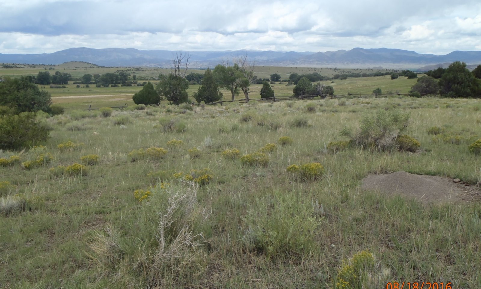
Figure 7. Landscape shot of the Foothill Loam site
This state is a mix of grasses and shrubs with some forbs. Natural ecological dynamics from fire, drought, and herbivory cause the shrub density to fluctuate. Where the site has more frags in the profile or texture is a little courser, species such as needleandthread may become more dominant.
Resilience management. The reference state shows the greatest resilience to disturbance. A diversity of plant functional-structural groups create a diversity of root systems which in turn takes in resources and feeds microbial communities. Bare ground is minimal due to a high degree of cover and litter.
Dominant plant species
-
fourwing saltbush (Atriplex canescens), shrub
-
rubber rabbitbrush (Ericameria nauseosa), shrub
-
western wheatgrass (Pascopyrum smithii), grass
-
needle and thread (Hesperostipa comata), grass
Community 1.1
Grass and Shrub Mix
Figure 8. Reference Community: Grass-Shrub Mix

Figure 9. Reference Community in the foreground
This community is grass dominant with a mix of shrubs and forbs. Western wheatgrass is the major grass. Others commonly present are needle and thread, upland/dryland sedges, littleseed ricegrass, and blue grama. There may be small amounts of slender wheatgrass, Scribner needlegrass, muttongrass, Junegrass, squirreltail, Indian ricegrass, sand dropseed, mountain muhly, and Arizona fescue. Forbs are minor with buckwheat, loco weed, and lupine most prevalent. Of the scattered shrubs, fourwing saltbush and rubber rabbitbrush are most common. Others are wax currant, gooseberry, Greene's and Douglas rabbitbrush, winterfat, and skunkbush sumac.
Resilience management. This community is the most resilient to disturbance. Natural disturbance such as fire, drought, and herbivory from multiple classes of fauna, plays a role in maintaining the reference community. Healthy plant and soil dynamics keeps the site populated with a large diversity of plants and root systems which sustains the community through disturbance.
Figure 10. Annual production by plant type (representative values) or group (midpoint values)
Table 5. Annual production by plant type
Plant type Low
(lb/acre)Representative value
(lb/acre)High
(lb/acre)Grass/Grasslike 600 900 1200 Shrub/Vine 120 180 240 Forb 80 120 160 Total 800 1200 1600 Figure 11. Plant community growth curve (percent production by month). CO5108 , Cool-season Dominant Warm-season Subdominant, MLRA 51 Alluvial Fans & fan Remnants. Reference Plant Community for Chico Fan located in LRU 51-5 on fans and fan remnants above valley floor, pre-dominantly in areas surrounding Villa Grove and Saguache, Saguache County..
Jan Feb Mar Apr May Jun Jul Aug Sep Oct Nov Dec J F M A M J J A S O N D 0 0 0 3 30 25 20 12 10 0 0 0 Community 1.2
Shrub Dominant
Figure 12. Shrub Dominant Community
Shrubs show increased cover and production with this community. Common shrubs include: fourwing saltbush, Greene's rabbitbrush, rubber rabbitbrush, skunkbush sumac, wax current, winterfat, and Wyoming big sagebrush.
Resilience management. Shrubs provide cover which captures precipitation. They also have deep taproots to bring up moisture and nutrients which provides resilience during times of drought. As diversity decreases over time so does resilience.
Community 1.3
Warm Season Grass Dominant
Figure 13. Warm Season Grass Dominant

Figure 14. Warm Season Grass Dominant

Figure 15. Warm season grass dominant with rabbitbrush and juniper
This is a warm season dominant community. Blue grama dominates the site. Other species present include purple threeawn, galleta, mat muhly, and sand dropseed. Greene's and rubber rabbitbrush become dominant. Trees are common around this site and are location on shallow soils and/or skeletal soils. Tree species (twoneedle pinyon, oneseed juniper, Rocky Mountain juniper, ponderosa pine and Douglas Fir) may begin to increase and occupy this site. If trees increase they are very minor.
Resilience management. This is considered an "at-risk" community phase. Long-term ecosystem drivers such as extended periods without fire and long-term herbivory targeted on palatable cool season species have created increased woody species, bare ground and erosion. Evergreens such as juniper, which are on the increase in this community can transpire throughout the year adding to the removal of moisture and contributing to droughty conditions. This community can no longer capture and maintain moisture like the community 1.1 and is therefore susceptible to crossing a threshold during an extended drought.
Pathway 1.1A
Community 1.1 to 1.2
Grass and Shrub Mix
Shrub DominantShrubs have slowly gained a competitive advantage due to deeper root systems which have the ability to access moisture and nutrients deeper in the profile than grasses. Extended periods between fire events will help give shrubs a competitive advantage.
Pathway 1.1B
Community 1.1 to 1.3
Grass and Shrub Mix
Warm Season Grass DominantThe greatest long-term driver is multiple years of grazing throughout the growing season. Preferred palatable species, such as western wheatgrass or needle and thread have less defense mechanisms than blue grama or purple threeawn. Eventually the site manifests itself with short-stature blue grama and increased bare ground. The shrubs have decreased due to disturbance such as fire, disease, excessive browsing, or human treatment.
Pathway 1.2A
Community 1.2 to 1.1
Shrub Dominant
Grass and Shrub MixAllowing fire into the system will set back shrubs and invigorate grass species. Other disturbances may be drought, disease, or excessive browsing.
Pathway 1.2B
Community 1.2 to 1.3
Shrub Dominant
Warm Season Grass DominantA disturbance, whether human caused or natural to decrease shrubs plus disturbance to decrease the palatable, cool season grasses.
Pathway 1.3A
Community 1.3 to 1.1
Warm Season Grass Dominant
Grass and Shrub MixThe goal is to reestablish ecosystem diversity and production with attentive grazing management that includes monitoring and adaptive options to focus on cool season species reclamation. An average to above average precipitation year will help with the pathway.
Pathway 1.3B
Community 1.3 to 1.2
Warm Season Grass Dominant
Shrub DominantAs fire frequency decreases, due to the lack of fine fuels, shrubs may find areas to germinate and grow. Once mature shrubs are established, basal sprouters, such as rabbitbrush, will gain a competitive advantage. Juniper may also increase due to extensive lateral and vertical root systems.
State 2
Degraded Shrub Dominant
Figure 16. Degraded Shrub Dominant
This site is dominated by bare ground and shrub species such as rubber rabbitbrush, Greene's rabbitbrush, and Wyoming big sagebrush. Bare ground is extensive. Warm season grasses are still present.
Resilience management. The site has crossed a threshold to a degraded state. A few resistant shrubs remain while bare ground and erosion is evident. Production and cover are both low.
Community 2.1
Degraded Shrub Dominant
Figure 17. Degraded Shrub State

Figure 18. Extensive bare ground and annuals between shrubs.
The Degraded Shrub Dominant community, at its worse is just a scattering of shrubs and annual forbs with large, continuous areas of bare ground.
Resilience management. Ecosystem health is very low as the site lacks the basic components to capture and maintain moisture. A few shrubs that have developed deep tap root systems remain and help anchor the site.
Community 2.2
Degraded Early Restoration
Figure 19. Western wheatgrass beginning to fill the spaces between shrubs.

Figure 20. Western wheatgrass re-colonizing between shrubs.
Restoration with the degraded shrub state begins with the re-establishment of western wheatgrass, a cool season rhizomatous species that can quickly begin to fill the spaces between shrubs and slow erosion.
Pathway 2.1A
Community 2.1 to 2.2
Degraded Shrub Dominant
Degraded Early RestorationRe-colonization of western wheatgrass during a good precipitation year.
Pathway 2.2A
Community 2.2 to 2.1
Degraded Early Restoration
Degraded Shrub DominantWestern wheatgrass has been set back due to drought or excessive herbivory.
State 3
Degraded, Increased Bare Ground
Figure 21. Degraded warm season dominant on convex position

Figure 22. Degraded warm season dominant on linear position
This state has crossed a threshold to a degraded state where bare ground is prevalent and warm season species is dominated by blue grama growing in a sod-forming fashion with low meristems and weak rhizomes. Other warm season grasses that may be present include threeawn and galleta.
Resilience management. Production and cover is low, bare ground and signs of erosion are evident. This state is highly susceptible to drought and further accelerated erosion.
Community 3.1
Degraded, Bare Ground, and Warm Season DominantThe community has crossed a threshold to a degraded state where bare ground is prevalent and warm season species is dominated by blue grama growing in a sod-forming fashion with low meristems and weak rhizomes. Other warm season grasses that may be present include threeawn and galleta.
Transition T1A
State 1 to 2
Reference
Degraded Shrub DominantSlow drivers include a reduced fire regime, often due to the lack of fine fuels; repetitive defoliation and high utilization of palatable species by domestic livestock, especially during drought; and soil destabilizing factors such as erosion.
Transition T1B
State 1 to 3
Reference
Degraded, Increased Bare GroundLong term drivers such as constant defoliation of preferred species, especially on convex positions which warm up faster in the spring and collect less precipitation in the winter, will degrade toward a bare ground-blue grama dominant site. Blue grama with low meristems and weak rhizomes will persist in these harsher convex areas.
Restoration pathway R2A
State 2 to 1
Degraded Shrub Dominant
ReferenceLong term management that improves ecosystem function. This includes restoring soil health and plant diversity. Western wheatgrass is often the first grass to begin recolonization in bare areas, re-establishing a network of rhizomes to begin restoration of site ecological processes. Careful management of grazing plus a possible re-introduction of fire into the systems will be needed for restoring plant and soil health.
Restoration pathway R3A
State 3 to 1
Degraded, Increased Bare Ground
ReferenceA long-term management system that monitors and adapts to periodic disturbance such as drought. Establishment of of ground cover, plant diversity, soil organic matter, and aggregate stability is important to re-establishing ecosystem function.
Additional community tables
Table 6. Community 1.1 plant community composition
Group Common name Symbol Scientific name Annual production () Foliar cover (%) Grass/Grasslike1 Grass/Grasslike 700–1100 western wheatgrass PASM Pascopyrum smithii 240–480 – needle and thread HECO26 Hesperostipa comata 120–240 – sedge CAREX Carex 80–160 – littleseed ricegrass PIMI Piptatheropsis micrantha 80–160 – blue grama BOGR2 Bouteloua gracilis 80–160 – squirreltail ELELE Elymus elymoides ssp. elymoides 40–80 – Indian ricegrass ACHY Achnatherum hymenoides 40–80 – Letterman's needlegrass ACLE9 Achnatherum lettermanii 20–40 – Scribner needlegrass ACSC11 Achnatherum scribneri 20–40 – purple threeawn ARPU9 Aristida purpurea 20–40 – prairie Junegrass KOMA Koeleria macrantha 20–40 – Sandberg bluegrass POSE Poa secunda 20–40 – muttongrass POFE Poa fendleriana 20–40 – Arizona fescue FEAR2 Festuca arizonica 0–20 – mountain muhly MUMO Muhlenbergia montana 0–20 – James' galleta PLJA Pleuraphis jamesii 0–20 – slender wheatgrass ELTR7 Elymus trachycaulus 0–20 – Shrub/Vine2 Shrubs 125–225 fourwing saltbush ATCA2 Atriplex canescens 80–160 – rubber rabbitbrush ERNA10 Ericameria nauseosa 40–80 – wax currant RICE Ribes cereum 20–40 – skunkbush sumac RHTR Rhus trilobata 20–40 – Greene's rabbitbrush CHGR6 Chrysothamnus greenei 10–20 – whitestem gooseberry RIIN2 Ribes inerme 10–20 – Wyoming big sagebrush ARTRW8 Artemisia tridentata ssp. wyomingensis 10–20 – winterfat KRLA2 Krascheninnikovia lanata 10–20 – prairie sagewort ARFR4 Artemisia frigida 10–20 – mountain snowberry SYOR2 Symphoricarpos oreophilus 0–20 – broom snakeweed GUSA2 Gutierrezia sarothrae 0–20 – plains pricklypear OPPO Opuntia polyacantha 0–10 – yellow rabbitbrush CHVI8 Chrysothamnus viscidiflorus 0–10 – Forb3 Forb 75–150 aster ASTER Aster 0–20 – milkvetch ASTRA Astragalus 0–20 – sulphur-flower buckwheat ERUM Eriogonum umbellatum 0–20 – lupine LUPIN Lupinus 0–20 – crownleaf evening primrose OECO2 Oenothera coronopifolia 0–20 – white locoweed OXSE Oxytropis sericea 0–20 – locoweed OXYTR Oxytropis 0–20 – beardtongue PENST Penstemon 0–20 – woolly plantain PLPA2 Plantago patagonica 0–20 – broom-like ragwort SESP3 Senecio spartioides 0–20 – scarlet globemallow SPCO Sphaeralcea coccinea 0–20 – Table 7. Community 1.2 plant community composition
Group Common name Symbol Scientific name Annual production () Foliar cover (%) Table 8. Community 1.3 plant community composition
Group Common name Symbol Scientific name Annual production () Foliar cover (%) Table 9. Community 2.1 plant community composition
Group Common name Symbol Scientific name Annual production () Foliar cover (%) Table 10. Community 2.2 plant community composition
Group Common name Symbol Scientific name Annual production () Foliar cover (%) Table 11. Community 3.1 plant community composition
Group Common name Symbol Scientific name Annual production () Foliar cover (%) Interpretations
Supporting information
Inventory data references
Location of Typical Example of Site: Above the buildings on Clyde Alexander ranch in South Tracy Canyon, about 12 miles south and 7 miles west of Saguache, Saguache County. Field Offices in Colorado where the site occurs: Alamosa, Center, and San Luis
References
-
. 2021 (Date accessed). USDA PLANTS Database. http://plants.usda.gov.
Other references
Chapman, S.S., G.E. Griffith, J.M. Omernik, A.B. Price, J. Freeouf, and D.L. Schrupp. 2006. Ecoregions of Colorado. (2-sided color posterwith map, descriptive text, summary tables, and photographs). U.S. Geological Survey, Reston, VA. Scale 1:1,200,000.
Cleland, D.T.; Freeouf, J.A.; Keys, J.E.; Nowacki, G.J.; Carpenter, C.A.; and McNab, W.H. 2007. Ecological Subregions: Sections andSubsections for the conterminous United States. Gen. Tech. Report WO-76D [Map on CD-ROM] (A.M. Sloan, cartographer). Washington,DC: U.S. Department of Agriculture, Forest Service, presentation scale 1:3,500,000; colored.
Soil Conservation Service (SCS). August 1975. Range Site Description for Limy Bench #276. : USDA, Denver Colorado.
United States Department of Agriculture, Natural Resources Conservation Service. 2006. Land Resource Regions and Major Land Resource Areas of the United States, the Caribbean, and the Pacific Basin. U.S. Department of Agriculture Handbook 296.Contributors
C. Villa, H. Garcia, T. Lucero
Scott WoodallApproval
Kirt Walstad, 12/12/2024
Acknowledgments
Project Staff: Suzanne Mayne-Kinney, Ecological Site Specialist, NRCS MLRA, Grand Junction SSO Alan Stuebe, MLRA Soil Survey Leader, NRCS MLRA Alamosa SSO Program Support: Rachel Murph, NRCS CO State Rangeland Management Specialist, Denver Eva Muller, Regional Director, Rocky Mountain Regional Soil Survey Office, Bozeman, MT B.J. Shoup, CO State Soil Scientist, Denver Eugene Backhaus, CO State Resource Conservationist, Denver --Site Development and Testing Plan--: Future work to validate and further refine the information in this Provisional Ecological Site Description is necessary. This will include field activities to collect low-, medium-, and high-intensity sampling, soil correlations, and analysis of that data. Additional information and data are required to refine the Plant Production and Annual Production tables for this ecological site. The extent of MLRA 51 must be further investigated. Field testing of the information contained in this Provisional ESD is required. As this ESD is moved to the Approved ESD level, reviews from the technical team, quality control, quality assurance, and peers will be conducted.
Rangeland health reference sheet
Interpreting Indicators of Rangeland Health is a qualitative assessment protocol used to determine ecosystem condition based on benchmark characteristics described in the Reference Sheet. A suite of 17 (or more) indicators are typically considered in an assessment. The ecological site(s) representative of an assessment location must be known prior to applying the protocol and must be verified based on soils and climate. Current plant community cannot be used to identify the ecological site.
Author(s)/participant(s) C. Villa, H. Garcia, T. Lucero Contact for lead author Date 12/15/2004 Approved by Approval date Composition (Indicators 10 and 12) based on Annual Production Indicators
-
Number and extent of rills:
None to slight. Some minor rilling may be found on steeper slopes. Widely spaced and short. -
Presence of water flow patterns:
Typically none on gentle slopes. Expect flow paths on steeper slopes following intense storms. Flow patterns are short and not connected. Debris obstructions present. -
Number and height of erosional pedestals or terracettes:
Pedestalled plants may exist in or near flow paths. Minor. -
Bare ground from Ecological Site Description or other studies (rock, litter, lichen, moss, plant canopy are not bare ground):
20% or less bare ground, with bare patches ranging from 6-10 inches in diameter. Prolonged drought or wildfire events will cause bare ground to increase upwards to 20-30% with bare patches ranging from 10-12 inches in diameter. -
Number of gullies and erosion associated with gullies:
None to slight. Gullies caused by off-site drainage may exist, caused by natural events. Gullies shallow with blunted edges and re-stabilizing. -
Extent of wind scoured, blowouts and/or depositional areas:
None -
Amount of litter movement (describe size and distance expected to travel):
Typically short at 1-3 feet following intense storms. -
Soil surface (top few mm) resistance to erosion (stability values are averages - most sites will show a range of values):
Stability class rating anticipated to be 4-5 in interspaces at soil surface. -
Soil surface structure and SOM content (include type of structure and A-horizon color and thickness):
These soils have a high water holding capacity and moderate permeability. Surface soil texture typically ranges from loam, fine sandy loam or clay loam. The A-horizon averages 0-13 inches in depth with a dark brown to dark grayish brown color. Structure ranges from a weak fine granular, moderate fine granular; to strong medium granular structure -
Effect of community phase composition (relative proportion of different functional groups) and spatial distribution on infiltration and runoff:
The composition/distribution of cool rhizomatous grasses, bunchgrasses and shrubs tend to slow overland flow and moderate runoff. Diverse canopy structure reduces raindrop impact allowing for increased time for infiltration. -
Presence and thickness of compaction layer (usually none; describe soil profile features which may be mistaken for compaction on this site):
None -
Functional/Structural Groups (list in order of descending dominance by above-ground annual-production or live foliar cover using symbols: >>, >, = to indicate much greater than, greater than, and equal to):
Dominant:
cool season rhizomatous grass >Sub-dominant:
cool season bunchgrass > shrubs = warm season bunchgrass >Other:
forbs > treesAdditional:
-
Amount of plant mortality and decadence (include which functional groups are expected to show mortality or decadence):
Minimal. Extended drought will increase plant mortality. Decadence can occur on areas void of grazing disturbance. -
Average percent litter cover (%) and depth ( in):
30-40% litter cover at 0.25 inch depth. Litter depth will increase under shrubs and trees. Litter cover during and following drought can range from 15-20% and 5-15% following wildfire. -
Expected annual annual-production (this is TOTAL above-ground annual-production, not just forage annual-production):
800 lbs./ac. low precipitation years; 1200 lbs./ac. average precipitation years; 1,600 lbs./ac. high precipitation years. After extended drought, production will be reduced by 200 – 400 lbs./ac. or more. -
Potential invasive (including noxious) species (native and non-native). List species which BOTH characterize degraded states and have the potential to become a dominant or co-dominant species on the ecological site if their future establishment and growth is not actively controlled by management interventions. Species that become dominant for only one to several years (e.g., short-term response to drought or wildfire) are not invasive plants. Note that unlike other indicators, we are describing what is NOT expected in the reference state for the ecological site:
Juniper species, pinyon, rabbitbrush. -
Perennial plant reproductive capability:
The only limitations are weather-related, wildfire, natural disease, inter-species competition, wildlife, and insects that may temporarily reduce reproductive capability.
Print Options
Sections
Font
AAAAOther
PrintThe Ecosystem Dynamics Interpretive Tool is an information system framework developed by the USDA-ARS Jornada Experimental Range, USDA Natural Resources Conservation Service, and New Mexico State University.
Accessibility statement


