
Natural Resources
Conservation Service
Ecological site R051XY279CO
Foothill Sand
9-12 PZ
Last updated: 12/11/2024
Accessed: 10/02/2026
-
Search


Major Land Resource Area or ecological site by name and/or ID.
PreviousSectionsNextGeneral information
Provisional. A provisional ecological site description has undergone quality control and quality assurance review. It contains a working state and transition model and enough information to identify the ecological site.
MLRA notes
Major Land Resource Area (MLRA): 051X–High Intermountain Valleys
This MLRA encompasses the San Luis Valley in south central Colorado and the Taos Plateau and Taos alluvial fans of north central New Mexico. As part of the northern portion of the Rio Grande Rift, the MLRA consists of large, alluvium filled basins washed down from adjacent mountain ranges. The Rio Grande River flows through this MLRA, continuing its long function of carrying mountain sediment down to the basin. Cenozoic volcanism is an extensive characteristic of the MLRA where large basalt flows with volcanic hills and domes are abundant. Ancient Lake Alamosa is a large feature within the MLRA.
LRU notes
The Foothill Sand site occurs on mountain front alluvial fans at the upper portion of the Piedmont slope, connected to the Sangre de Cristo Mountains. Most of the alluvial fans have been dissected, leaving erosional fan remnants as component landforms standing above wash channels or inset fans. The source of parent material is a mixing of both alluvial material from the Sangre de Cristo Mountains and eolian material blown in from the San Luis Valley's sand sheet and active dune field.
Classification relationships
NRCS:
Major Land Resource Area 51, High Intermountain Valleys (United States Department of Agriculture, Natural Resources Conservation Service, 2006).
USFS:
331J – Northern Rio Grande Basin M331Ic > 331Ja - San Luis Valley, 331Jb - San Luis Hills and 331C - Mogotes
EPA:
22 - Arizona/New Mexico Plateau > 22a - San Luis Shrublands and Hills ; 22b -San Luis Alluvial Flats and Wetlands ; 22c - Salt Flats; 22e - Sand Dunes and Sand Sheets and 22f -Taos Plateau (Griffith, 2006).
USGS:
Southern Rocky Mountain ProvinceEcological site concept
Surface textures range from very cobbly sandy loam to loamy sand. Taxonomic particle size class ranges from loamy-skeletal to sandy. Soils are deep and slope commonly ranges from 4 to 15 percent. Vegetatively, the site is a mix of grasses and shrubs along a gradient from alluvium derived cobbly sandy-loam surface textures to eolian derived loamy-sand. There are stringers of pinyon and juniper extending down from the colluvial apron of the mountain-base and some scattered P-J throughout the site.
Associated sites
R051XY276CO Limy Bench
Limy bench are sometimes skeletal and have a fine-loamy particle size class. Limy bench is derived from igneous geology, and particular extrusive volcanic material that tends to break down into finer soils that are higher in pH.
R051XY263CO Salt Flats
The Salt Flats site can be found around some of the bottom fringes of the foothill sands site and occurs on the alluvial flat component of the basin floor. It is associated with vegetation that is tolerant of higher alkalinity.
R051XY317CO Foothill Loam
The Foothill Loam site does not have the eolian influence and textures are not as course.T he Foothill Loam Site is primarily a grassland community located a little higher up on the mountain front alluvial fans. It is located in the 12-16 inch precipitation zone.
R051XY294CO Valley Sand
The Valley Sand site occurs on the alkali flat of the basin floor. The soils are derived from course-textured alluvium which has been wind-worked over time. Often there is a deep water table which is accessible to deep-rooted shrubs.
Similar sites
R051XY275CO Deep Sands 7-9 PZ
The Deep Sands site is part of the sand sheet that surrounds the active dune field. This site is coarse loamy; deep to very deep in depth and is non-saline. It occurs on dunes and sand sheets. Sand Hummocks occur as dunes in the playa and are saline.
R051XY294CO Valley Sand
The Valley Sand site occurs on the alkali flat of the basin floor. The soils are derived from course-textured alluvium which has been wind-worked over time. Often there is a deep water table which is accessible to deep-rooted shrubs.
R051XY312CO Sand Hummocks
It essentially occupies the playa dune component where salts and sand accumulate on the leeward side of the playa.
Table 1. Dominant plant species
Tree (1) Pinus edulis
(2) Juniperus osteospermaShrub Not specified
Herbaceous (1) Achnatherum scribneri
(2) Hesperostipa comataPhysiographic features
This site occurs on the east side of the San Luis Valley on gentle to moderately steep fans and slopes just below the steeper pinyon-covered lands. The site is positioned between the San Luis Valley's active dune field with surrounding sand sheet and the colluvial apron at the base of the Sangre de Cristo Mountains. Most of the fans have been dissected, leaving erosional fan remnants as component landforms standing above wash channels or inset fans.
Table 2. Representative physiographic features
Landforms (1) Fan
Runoff class Low Flooding frequency None Ponding frequency None Elevation 7800 – 8500 ft Slope 9 – 15 % Aspect W, NW, SW Climatic features
The climate that typifies the High Intermountain Valley, ranges from arid to semi-arid, and is characterized by cold winters, moderate summers, and much sunshine. The San Juan mountain range to the west and the Sangre de Cristo Mountains to the east intercept much of the precipitation causing a two-way rain shadow effect. Cold air from the encompassing mountain ranges drain into the valley and settle. This phenomena results in long cold winters and moderate summer temperatures. Average annual precipitation is 9 to 12 inches. Of this, 55-60% falls between May 1 and September 1, mostly as hard, spotty thunder showers in July and August. May and June are normally dry. Winter snow is light but makes up a slightly higher percent of the total than in the San Luis Valley proper. Snow is usually present during the coldest weather. However, snow cover is light or patchy during much of some winters. Wide seasonal and yearly variations are common. Major native plants make most of their growth between early May and late July, sometimes extending through most of August. Some plants normally complete growth by mid-June and may make late growth.
Mean annual temperature is 41 degrees to 43 degrees F. Average frost-free period is 85 to 100 days, from late May to early June to September. Summer daytime temperatures are frequently in the low 80's, but rarely exceed 90 degrees F, and nights are cool. Temperatures of -20 degrees to -30 degrees F can be expected each year and are common some winters. Winds that often reach high velocities are common, especially in spring. Relative humidity is often low. Even so, evaporation rates average lower than those of many dry regions because of the cooler climate.Table 3 Representative climatic features
Frost-free period (characteristic range) 80-90 days Freeze-free period (characteristic range) 100-120 days Precipitation total (characteristic range) 10-10 in Frost-free period (actual range) 80-90 days Freeze-free period (actual range) 100-120 days Precipitation total (actual range) 10-10 in Frost-free period (average) 90 days Freeze-free period (average) 110 days Precipitation total (average) 10 in Characteristic rangeActual rangeBarLineFigure 1. Monthly precipitation range
Characteristic rangeActual rangeBarLineFigure 2. Monthly minimum temperature range
Characteristic rangeActual rangeBarLineFigure 3. Monthly maximum temperature range
BarLineFigure 4. Monthly average minimum and maximum temperature
Figure 5. Annual precipitation pattern
Figure 6 Annual average temperature pattern
Climate stations used
-
(1) GREAT SAND DUNES NM [USC00053541], Mosca, CO
-
(2) BLANCA 4 NW [USC00050776], Blanca, CO
">Influencing water features
This is does not have a water table.
Soil features
The source of parent material is a mixing from both alluvial material from the Sangre de Cristo Mountains and material from the San Luis Valley's sand sheet and active dune field. Surface texture range is usually loamy sand. Taxonomic particle size class range is sandy. Soils are very deep.
Typical soil correlated to this site is Ouray.Table 4. Representative soil features
Parent material (1) Alluvium
Surface texture (1) Loamy sand
Family particle size (1) Sandy
Drainage class Excessively drained Permeability class Rapid Soil depth 60 – 120 in Surface fragment cover <=3" Not specified Surface fragment cover >3" Not specified Available water capacity
(Depth not specified)2.4 – 3.1 in Calcium carbonate equivalent
(Depth not specified)Not specified Electrical conductivity
(Depth not specified)Not specified Sodium adsorption ratio
(Depth not specified)Not specified Soil reaction (1:1 water)
(Depth not specified)6.6 – 7.3 Subsurface fragment volume <=3"
(Depth not specified)Not specified Subsurface fragment volume >3"
(Depth not specified)Not specified Ecological dynamics
A rather a open scattered and growth patchy of growth grasses of and pinyon shrubs pine and characterizes juniper mixed the site. Major grasses include Scribner needdlegrass, Indian ricegrass, Western and thickspike needlegrass, June grass and blue grama. Other common grasses are sand dropseed, squirreltail, blowout grass, muttongrass, littleseed ricegrass. Forbs such as buckwheat, paintbrush, locos, and pingue occur in small are amounts, but are conspicuous when in bloom. Dominant shrubs are mountain mahogany, skunkbush, wax currant, gooseberry, tall rabbitbrush, snowberry and serviceberry. Trace currant, amounts gooseberry, of four-wing saltbush, winterfat, horsebrush, yucca, prickly pear, and rock spirea are usually present.
There is a gradient of vegetation with grasses being more prominent in the alluvium influenced areas and shrubs in the eolian influenced areas. Pinyon and juniper becomes more dense as one moves higher onto the colluvial apron of the bounding mountain range.State and transition model
More interactive model formats are also available. View Interactive Models
Click on state and transition labels to scroll to the respective textEcosystem states
State 1 submodel, plant communities
State 2 submodel, plant communities
State 1
Reference
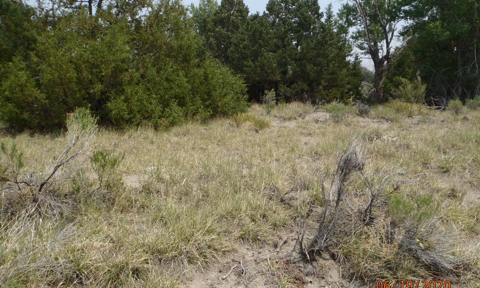
Figure 7. Loamy Sand Soils where an eolian cap exists
The reference state is mostly grasses with a few forbs, shrubs, and trees. As the site grades towards the sandier areas, shrubs increase. As the site grades toward the colluvial apron of the Sangre de Cristo Range, pinyon and juniper increase. Major grasses include Scribner needlegrass, needle-and-thread, Indian ricegrass, and blue grama.
Resilience management. The reference community phase has the greatest resilience to disturbance. A diversity of root systems from deep tap roots to abundant fibrous hold the soil in place and take advantage of moisture and nutrients throughout the profile.
Dominant plant species
-
twoneedle pinyon (Pinus edulis), tree
-
Utah juniper (Juniperus osteosperma), tree
-
alderleaf mountain mahogany (Cercocarpus montanus), shrub
-
Scribner needlegrass (Achnatherum scribneri), grass
Community 1.1
Scribner Needlegrass, Needle and Thread, Indian Ricegrass, and Blue Grama
The reference community phase is primarily a grassland community with forbs, shrubs, and scattered pinyon-juniper. Major grasses include Scribner needlegrass, needle-and-thread, Indian ricegrass, and blue grama.
Resilience management. The reference community phase has the greatest resilience to disturbance. A diversity of root systems from deep tap roots to abundant fibrous hold the soil in place and take advantage of moisture and nutrients throughout the profile.
Figure 8. Annual production by plant type (representative values) or group (midpoint values)
Table 5. Annual production by plant type
Plant type Low
(lb/acre)Representative value
(lb/acre)High
(lb/acre)Grass/Grasslike 440 605 770 Shrub/Vine 200 275 350 Tree 80 110 140 Forb 80 110 140 Total 800 1100 1400 Figure 9. Plant community growth curve (percent production by month). CO5109 , Cool-season/Warm-season co-dominant, coarse textured soils, alluvial fans and benches. Located in LRU 51-5 on fans and fan remnants above valley floor, pre-dominantly in Saguache County, Villa Grove and Saguache area..
Jan Feb Mar Apr May Jun Jul Aug Sep Oct Nov Dec J F M A M J J A S O N D 0 0 0 2 35 30 25 5 3 0 0 0 Community 1.2
Shrub Dominant
Figure 10. Grasses have decreased and shrubs have the greater percentage of species composition.
This is an "at risk" community phase where palatable grass species, especially cool-season bunch grasses, have been greatly reduced leaving lesser palatable grasses, shrubs, and forbs. Common plants in this community include blue grama, sand dropseed, purple threeawn, slimstem muhly, sandhill muhly, snakeweed, pingue, rabbitbrush, Apache plume, yucca, and prickly pear. Reference cool-season species are still present within protected places.
Resilience management. This site is at risk to crossing a threshold to a degraded state. Drought is often the trigger, causing the site to cross a threshold. Important soil stabilizing features such as healthy grass cover and root systems have been reduced making the A horizon susceptible to erosion.
Pathway 1.1A
Community 1.1 to 1.2
Scribner Needlegrass, Needle and Thread, Indian Ricegrass, and Blue Grama
Shrub DominantLong term repetitive defoliation with high utilization rates on cool-season palatable species without rest or recovery, especially throughout the growing season, will eventually weaken root systems and cause plant mortality. Less palatable warm-season species remain.
Pathway 1.2A
Community 1.2 to 1.1
Shrub Dominant
Scribner Needlegrass, Needle and Thread, Indian Ricegrass, and Blue GramaBy applying a grazing management strategy that allows critical cool season species such as Indian ricegrass, Scribner needlegrass, and needle-and-thread to grow without repetitive defoliation. Grass species will begin to colonize within the inter-spaces between shrubs.
State 2
Degraded
Resilience management. This state has low resilience to disturbance as is prone to excessive soil erosion and deposition.
Community 2.1
Bare Ground Dominant
The degraded state is anchored by a few shrubs but have lost the majority of grasses. This state has crosses a threshold to where bare ground is prominent along with a few species that have defensive biological and chemical responses to grazing. Annuals are common following moisture events. The A horizon is mostly gone and soil loss due to erosion has accelerated.
Transition T1B
State 1 to 2A major long-term driver is repetitive, high utilization without rest or recovery of plant species throughout the growing season for multiple years, or during drought, which has caused die-off of preferred grasses, forbs, and shrubs. As more plants die, bare ground increases and overall ecosystem function and health decrease to a degree that the site crosses a threshold.
Restoration pathway R2A
State 2 to 1Long term management where ecosystem processes are restored, such as soil organic matter, aggregate stability, plant colonization, and cover.
Additional community tables
Table 6. Community 1.1 plant community composition
Group Common name Symbol Scientific name Annual production () Foliar cover (%) Grass/Grasslike1 500–700 Scribner needlegrass ACSC11 Achnatherum scribneri 240–420 – Indian ricegrass ACHY Achnatherum hymenoides 120–210 – needle and thread HECO26 Hesperostipa comata 120–210 – blue grama BOGR2 Bouteloua gracilis 80–140 – thickspike wheatgrass ELLAL Elymus lanceolatus ssp. lanceolatus 40–70 – sand dropseed SPCR Sporobolus cryptandrus 40–70 – blowout grass REFL Redfieldia flexuosa 40–70 – squirreltail ELELE Elymus elymoides ssp. elymoides 20–35 – purple threeawn ARPU9 Aristida purpurea 20–35 – sun sedge CAINH2 Carex inops ssp. heliophila 0–20 – roughleaf ricegrass ORAS Oryzopsis asperifolia 0–20 – ring muhly MUTO2 Muhlenbergia torreyi 0–5 – pine dropseed BLTR Blepharoneuron tricholepis 0–5 – prairie Junegrass KOMA Koeleria macrantha 0–5 – Arizona fescue FEAR2 Festuca arizonica 0–5 – ring muhly MUTO2 Muhlenbergia torreyi 0–5 – Forb2 90–130 snowball sand verbena ABFR2 Abronia fragrans 0–14 – fragrant snakeroot AGHE5 Ageratina herbacea 0–14 – white sagebrush ARLU Artemisia ludoviciana 0–14 – Wyoming Indian paintbrush CALI4 Castilleja linariifolia 0–14 – hairy clematis CLHI Clematis hirsutissima 0–14 – sulphur-flower buckwheat ERUM Eriogonum umbellatum 0–14 – hairy false goldenaster HEVI4 Heterotheca villosa 0–14 – pingue rubberweed HYRI Hymenoxys richardsonii 0–14 – scarlet gilia IPAG Ipomopsis aggregata 0–14 – narrowleaf stoneseed LIIN2 Lithospermum incisum 0–14 – hoary tansyaster MACA2 Machaeranthera canescens 0–14 – lacy tansyaster MAPI Machaeranthera pinnatifida 0–14 – oblongleaf bluebells MEOB Mertensia oblongifolia 0–14 – Colorado four o'clock MIMU Mirabilis multiflora 0–14 – beardtongue PENST Penstemon 0–14 – Rocky Mountain penstemon PEST2 Penstemon strictus 0–14 – broom-like ragwort SESP3 Senecio spartioides 0–14 – scarlet globemallow SPCO Sphaeralcea coccinea 0–14 – Shrub/Vine3 225–325 alderleaf mountain mahogany CEMO2 Cercocarpus montanus 120–210 – wax currant RICE Ribes cereum 80–140 – skunkbush sumac RHTR Rhus trilobata 40–70 – rubber rabbitbrush ERNA10 Ericameria nauseosa 40–70 – whitestem gooseberry RIINI Ribes inerme var. inerme 20–35 – Saskatoon serviceberry AMAL2 Amelanchier alnifolia 20–35 – mountain snowberry SYOR2 Symphoricarpos oreophilus 10–21 – fourwing saltbush ATCA2 Atriplex canescens 0–14 – rockspirea HODU Holodiscus dumosus 0–14 – winterfat KRLA2 Krascheninnikovia lanata 0–14 – plains pricklypear OPPO Opuntia polyacantha 0–14 – chokecherry PRVI Prunus virginiana 0–14 – soapweed yucca YUGL Yucca glauca 0–14 – broom snakeweed GUSA2 Gutierrezia sarothrae 0–14 – prairie sagewort ARFR4 Artemisia frigida 0–14 – Tree4 85–135 Utah juniper JUOS Juniperus osteosperma 40–70 – twoneedle pinyon PIED Pinus edulis 40–70 – Rocky Mountain juniper JUSC2 Juniperus scopulorum 0–35 – Table 7. Community 1.2 plant community composition
Group Common name Symbol Scientific name Annual production () Foliar cover (%) Table 8. Community 2.1 plant community composition
Group Common name Symbol Scientific name Annual production () Foliar cover (%) Interpretations
Supporting information
Inventory data references
Location of Typical Example of the Site: East side of Pinyon Pasture on Baca Gran in Saguaches County Foothill Area Just east of Sand Dunes National Monument in Alamosa County. Field Offices in Colorado where the site occurs: Alamosa, and Center
References
-
. 2021 (Date accessed). USDA PLANTS Database. http://plants.usda.gov.
Other references
Chapman, S.S., G.E. Griffith, J.M. Omernik, A.B. Price, J. Freeouf, and D.L. Schrupp. 2006. Ecoregions of Colorado. (2-sided color posterwith map, descriptive text, summary tables, and photographs). U.S. Geological Survey, Reston, VA. Scale 1:1,200,000.
Cleland, D.T.; Freeouf, J.A.; Keys, J.E.; Nowacki, G.J.; Carpenter, C.A.; and McNab, W.H. 2007. Ecological Subregions: Sections andSubsections for the conterminous United States. Gen. Tech. Report WO-76D [Map on CD-ROM] (A.M. Sloan, cartographer). Washington,DC: U.S. Department of Agriculture, Forest Service, presentation scale 1:3,500,000; colored.
Soil Conservation Service (SCS). February 1977. Range Site Description for Foothill Sand #279. : USDA, Denver Colorado.
United States Department of Agriculture, Natural Resources Conservation Service. 2006. Land Resource Regions and Major Land Resource Areas of the United States, the Caribbean, and the Pacific Basin. U.S. Department of Agriculture Handbook 296.Contributors
C. Villa, H. Garcia
Suzanne Mayne-KinneyApproval
Kirt Walstad, 12/11/2024
Acknowledgments
Project Staff: Suzanne Mayne-Kinney, Ecological Site Specialist, NRCS MLRA, Grand Junction SSO Alan Stuebe, MLRA Soil Survey Leader, NRCS MLRA Alamosa SSO Program Support: Rachel Murph, NRCS CO State Rangeland Management Specialist, Denver Eva Muller, Regional Director, Rocky Mountain Regional Soil Survey Office, Bozeman, MT B.J. Shoup, CO State Soil Scientist, Denver Eugene Backhaus, CO State Resource Conservationist, Denver --Site Development and Testing Plan--: Future work to validate and further refine the information in this Provisional Ecological Site Description is necessary. This will include field activities to collect low-, medium-, and high-intensity sampling, soil correlations, and analysis of that data. Additional information and data are required to refine the Plant Production and Annual Production tables for this ecological site. The extent of MLRA 51 must be further investigated. Field testing of the information contained in this Provisional ESD is required. As this ESD is moved to the Approved ESD level, reviews from the technical team, quality control, quality assurance, and peers will be conducted.
Rangeland health reference sheet
Interpreting Indicators of Rangeland Health is a qualitative assessment protocol used to determine ecosystem condition based on benchmark characteristics described in the Reference Sheet. A suite of 17 (or more) indicators are typically considered in an assessment. The ecological site(s) representative of an assessment location must be known prior to applying the protocol and must be verified based on soils and climate. Current plant community cannot be used to identify the ecological site.
Author(s)/participant(s) C. Villa, H. Garcia Contact for lead author Date 12/15/2004 Approved by Approval date Composition (Indicators 10 and 12) based on Annual Production Indicators
-
Number and extent of rills:
None -
Presence of water flow patterns:
Typically none on gentle slopes. Expect flow paths on steeper slopes (>10%), following intense storms. Flow patterns are short and not connected. Debris obstructions present. -
Number and height of erosional pedestals or terracettes:
Pedestalled plants are common near or in flow paths and on windward positions where wind scouring is more likely to naturally occur. -
Bare ground from Ecological Site Description or other studies (rock, litter, lichen, moss, plant canopy are not bare ground):
30% or less bare ground, with bare patches ranging from 8-12 inches in diameter. Prolonged drought or wildfire events will cause bare ground to increase upwards to 25-40% with bare patches ranging from 12-20 inches in diameter. -
Number of gullies and erosion associated with gullies:
None -
Extent of wind scoured, blowouts and/or depositional areas:
Wind scouring is inherent to this site. Soil movement can intensify with disturbances such as wildfire, repeated grazing, or extended drought. -
Amount of litter movement (describe size and distance expected to travel):
Litter will move on this site. Litter movement consists of re-distribution of fine litter in flow patterns and on leeward side of bunchgrasses/shrubs. -
Soil surface (top few mm) resistance to erosion (stability values are averages - most sites will show a range of values):
Stability class rating anticipated to be 3-4 in interspaces at soil surface. -
Soil surface structure and SOM content (include type of structure and A-horizon color and thickness):
These soils have a high infiltration rate, low water holding capacity and moderately rapid to rapid permeability. Surface soil texture are usually a loamy sand. The A-horizon averages 0-13 inches in depth with a grayish brown or brown color. Structure ranges from a weak medium subangular blocky structure parting to weak fine granular structure. -
Effect of community phase composition (relative proportion of different functional groups) and spatial distribution on infiltration and runoff:
The composition/distribution of bunchgrasses and shrub/tree tends to slow overland flow and moderate runoff. Diverse canopy structure reduces raindrop impact allowing for increased time for infiltration. -
Presence and thickness of compaction layer (usually none; describe soil profile features which may be mistaken for compaction on this site):
None -
Functional/Structural Groups (list in order of descending dominance by above-ground annual-production or live foliar cover using symbols: >>, >, = to indicate much greater than, greater than, and equal to):
Dominant:
cool season bunchgrass >Sub-dominant:
shrubs > trees > warm season bunchgrass >Other:
forbs = cool season rhizomatous grassAdditional:
-
Amount of plant mortality and decadence (include which functional groups are expected to show mortality or decadence):
Minimal. Extreme drought will increase plant mortality. Decadence can occur on areas void of grazing disturbance. -
Average percent litter cover (%) and depth ( in):
20-30% litter cover at 0.25 inch depth. Litter depth will increase under shrubs and trees. Litter cover during and following drought can range from 10-15% and 5-10% following wildfire. -
Expected annual annual-production (this is TOTAL above-ground annual-production, not just forage annual-production):
800 lbs./ac. low precipitation years; 1100 lbs./ac. average precipitation years; 1,400 lbs./ac. high precipitation years. After extended drought, production will be reduced by 200 – 400 lbs./ac. or more. -
Potential invasive (including noxious) species (native and non-native). List species which BOTH characterize degraded states and have the potential to become a dominant or co-dominant species on the ecological site if their future establishment and growth is not actively controlled by management interventions. Species that become dominant for only one to several years (e.g., short-term response to drought or wildfire) are not invasive plants. Note that unlike other indicators, we are describing what is NOT expected in the reference state for the ecological site:
Juniper and rabbitbrush species. -
Perennial plant reproductive capability:
The only limitations are weather-related, wildfire, natural disease, inter-species competition, wildlife, and insects that may temporarily reduce reproductive capability.
Print Options
Sections
Font
AAAAOther
PrintThe Ecosystem Dynamics Interpretive Tool is an information system framework developed by the USDA-ARS Jornada Experimental Range, USDA Natural Resources Conservation Service, and New Mexico State University.
Accessibility statement


