Natural Resources
Conservation Service
Ecological site R047XB406UT
Mountain Gravelly Loam
(mountain big sagebrush)
Last updated: 2/06/2025
Accessed: 07/05/2026
-
Search


Major Land Resource Area or ecological site by name and/or ID.
PreviousSectionsNextGeneral information
Provisional. A provisional ecological site description has undergone quality control and quality assurance review. It contains a working state and transition model and enough information to identify the ecological site.
MLRA notes
Major Land Resource Area (MLRA): 047X–Wasatch and Uinta Mountains
MLRA 47 occurs in Utah (86 percent), Wyoming (8 percent), Colorado (4 percent), and Idaho (2 percent). It encompasses approximately 23,825 square miles (61,740 square kilometers). The northern half of this area is in the Middle Rocky Mountains Province of the Rocky Mountain System. The southern half is in the High Plateaus of the Utah Section of the Colorado Plateaus Province of the Intermontane Plateaus. Parts of the western edge of this MLRA are in the Great Basin Section of the Basin and Range Province of the Intermontane Plateaus. The MLRA includes the Wasatch Mountains, which trend north and south, and the Uinta Mountains, which trend east and west. The steeply sloping, precipitous Wasatch Mountains have narrow crests and deep valleys. Active faulting and erosion are a dominant force in controlling the geomorphology of the area. The Uinta Mountains have a broad, gently arching, elongated shape. Structurally, they consist of a broadly folded anticline that has an erosion-resistant quartzite core. The Wasatch and Uinta Mountains have an elevation of 4,900 to about 13,500 feet (1,495 to 4,115 meters).
The mountains in this area are primarily fault blocks that have been tilted up. Alluvial fans at the base of the mountains are recharge zones for the basin fill aquifers. An ancient shoreline of historic Bonneville Lake is evident on the footslopes along the western edge of the area. Rocks exposed in the mountains are mostly Mesozoic and Paleozoic sediments, but Precambrian rocks are exposed in the Uinta Mountains. The Uinta Mountains are one of the few ranges in the United States that are oriented west to east. The southern Wasatch Mountains consist of Tertiary volcanic rocks occurring as extrusive lava and intrusive crystalline rocks.
The average precipitation is from 8 to 16 inches (203 to 406 mm) in the valleys and can range up to 73 inches (1854 mm) in the mountains. In the northern and western portions of the MLRA, peak precipitation occurs in the winter months. The southern and eastern portions have a greater incidence of high-intensity summer thunderstorms; hence, a significant amount of precipitation occurs during the summer months. The average annual temperature is 30 to 50 degrees Fahrenheit (-1 to 15 C). The freeze-free period averages 140 days and ranges from 60 to 220 days, generally decreasing in length with elevation.
The dominant soil orders in this MLRA are Aridisols, Entisols, Inceptisols, and Mollisols. The lower elevations are dominated by a frigid temperature regime, while the higher elevations experience cryic temperature regimes. Mesic temperature regimes come in on the lower elevations and south facing slopes in the southern portion of this MLRA. The soil moisture regime is typically xeric in the northern part of the MLRA, but grades to ustic in the extreme eastern and southern parts. The mineralogy is generally mixed and the soils are very shallow to very deep, generally well drained, and loamy or loamy-skeletal.LRU notes
E47B is the Wasatch Mountains South MLRA. It occurs in the Loa, Panguitch, New Harmony area. Most of Zion, Bryce Canyon National Parks and Cedar Breaks National Monument are in this area. This area is composed of mountain ranges that run north and south.
Ecological site concept
The soils of this site formed mostly in slope alluvium/colluvium from igneous and sedimentary rock. Surface soils are fine gravelly loam to fine sandy loam in texture. These soils are deep to very deep, well-drained, and have moderate permeability. The pH is slightly to moderately alkaline. Available water-holding capacity ranges from 3.0 to 4.6 inches of water in the upper 60 inches of soil. The soil moisture regime is mostly ustic and the soil temperature regime is frigid. Precipitation ranges from 16 to 22 inches annually.
Associated sites
R047XB475UT Mountain Windswept Ridge (black sagebrush or low sagebrush)
This sites normally surrounds the Mountain Gravelly Loam (Mt Big Sagebrush) site and is the source of the snow drifts.
R047XB430UT Mountain Loam (mountain big sagebrush)
Found in the bottoms below this site and less gravels in the profile.
Similar sites
R047XB420UT Mountain Loam (shrub)
This site has less big sagebrush and more bitterbrush and other browse species.
R047XB430UT Mountain Loam (mountain big sagebrush)
This site has less gravelly soils and is more productive and usually on gentler slopes.
Table 1. Dominant plant species
Tree Not specified
Shrub (1) Artemisia tridentata ssp. vaseyana
Herbaceous (1) Elymus trachycaulus
Physiographic features
This ecosite occurs on rolling foothills, mainly on the north and northwest side slopes. Runoff is medium to high depending on the slope. Slopes generally range from 8 to 35 percent but maybe as low as two percent.

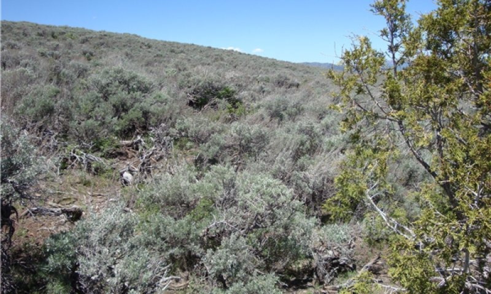
Figure 1. Mountain Gravelly Loam (Mt Big Sage) on Parker Mountain
Table 2. Representative physiographic features
Landforms (1) Hill
(2) Fan remnant
Runoff class Medium to high Flooding frequency None Ponding frequency None Elevation 8000 – 9700 ft Slope 8 – 35 % Aspect NW, N Climatic features
Climate is characterized by cool summers and cold winters. The annual precipitation on this site occurs with about 50 percent arriving during the growing season. The wettest months are August through March. The driest are May and June. The average snow depth in the winter is between 12 and 24 inches. Summer thunderstorms are typical in July and August. Mean annual temperature is 45 degrees.
Table 3 Representative climatic features
Frost-free period (characteristic range) Freeze-free period (characteristic range) Precipitation total (characteristic range) 20-20 in BarLineFigure 2. Monthly precipitation range
BarLineFigure 3. Monthly average minimum and maximum temperature
">Influencing water features
No water features associated with this site.
Wetland description
N/A
Soil features
Characteristic soils in this site are very deep and well-drained. The soil moisture and temperature regimes are ustic and frigid respectively. The dry surface color is typically brown to very dark brown. These soils are formed in alluvium and colluvium derived mainly from andesite, dacite and basalt on side slopes of hills under resilient snow drifts.
Surface soil textures are typically gravelly loam and subsoil textures are extremely cobbly sandy clay loam. The soils are non-saline and slightly to moderately alkaline.
This ecological site has been used in the following soil surveys and has been correlated to the following components:
UT629 (Loa-Marysvale) - Brow
Typical Soil Profile:
A1 - 0 to 7 inches; gravelly loam
A2 - 7 to 20 inches; very gravelly loam
Btk - 20 to 33 inches; extremely cobbly sandy clay loam
C - 33 to 61 inches; extremely cobbly sandy loamTable 4. Representative soil features
Parent material (1) Alluvium – andesite
(2) Colluvium – andesite
(3) Alluvium – basalt
(4) Colluvium – basalt
(5) Alluvium – dacite
(6) Colluvium – dacite
Surface texture (1) Gravelly loam
(2) Fine sandy loam
Family particle size (1) Loamy-skeletal
Drainage class Well drained Permeability class Moderate Depth to restrictive layer 40 – 60 in Soil depth 60 – 80 in Surface fragment cover <=3" 5 – 25 % Surface fragment cover >3" 5 – 7 % Available water capacity
(Depth not specified)3 – 4.6 in Calcium carbonate equivalent
(Depth not specified)0 – 5 % Electrical conductivity
(Depth not specified)0 – 2 mmhos/cm Sodium adsorption ratio
(Depth not specified)0 – 4 Soil reaction (1:1 water)
(Depth not specified)7.4 – 8.4 Subsurface fragment volume <=3"
(Depth not specified)17 – 30 % Subsurface fragment volume >3"
(Depth not specified)26 – 33 % Ecological dynamics
It is impossible to determine in any quantitative detail the Historic Climax Plant Community (HCPC) for this ecological site because of the lack of direct historical documentation preceding all human influence. In some areas, the earliest reports of dominant plants include the cadastral survey conducted by the General Land Office, which began in the late 19th century for this area. However, up to the 1870s the Shoshone Indians, prevalent in northern Utah and neighboring states, grazed horses and set fires to alter the vegetation for their needs. Europeans brought cattle and horses to the area, grazing large numbers of them on unfenced parcels year-long. Itinerant and local sheep flocks followed, largely replacing cattle as the browse component increased.
Below is a State and Transition Model diagram to illustrate the “phases” (common plant communities), and “states” (aggregations of those plant communities) that can occur on the site. Differences between phases and states depend primarily upon observations of a range of disturbance histories in areas where this ESD is represented. These situations include grazing gradients to water sources, fence-line contrasts, patches with differing dates of fire, herbicide treatment, tillage, etc. Reference State 1 illustrates the common plant communities that probably existed just prior to European settlement.
The major successional pathways within states, (“community pathways”) are indicated by arrows between phases. “Transitions” are indicated by arrows between states. The drivers of these changes are indicated in codes decipherable by referring to the legend at the bottom of the page and by reading the detailed narratives that follow the diagram. The transition between Reference State 1 and State 2 is considered irreversible because of the naturalization of exotic species of both flora and fauna, possible extinction of native species, and climate change. There may have also been accelerated soil erosion.
When available, monitoring data (of various types) were employed to validate more subjective inferences made in this diagram. See the complete files in the office of the State Range Conservationist for more details.
The plant communities shown in this State and Transition Model may not represent every possibility, but are probably the most prevalent and recurring plant communities. As more monitoring data are collected, some phases or states may be revised, removed, or new ones may be added. None of these plant communities should necessarily be thought of as “Desired Plant Communities.” According to the USDA NRCS National Range and Pasture Handbook (USDA-NRCS 2003), Desired Plant Communities (DPC’s) will be determined by the decision-makers and will meet minimum quality criteria established by the NRCS. The main purpose for including descriptions of a plant community is to capture the current knowledge at the time of this revision.
State 1: Reference State
The Reference State is a description of this ecological site just prior to Euro-American settlement but long after the arrival of Native Americans. The description of the Reference State was determined by NRCS Soil Survey Type Site Location information and familiarity with rangeland relict areas where they exist. The least modified plant community would have been co-dominated by mountain big sagebrush (Artemisia tridentata ssp. vaseyana) and a mixture of herbaceous species (1.1). The primary disturbance factor prior to European colonization would have been wildfire (1.1a), which would have removed the sagebrush and allowed the herbs to dominate for a time (1.2) As the time elapsed since the last wildfire grew longer (1.2a), mountain big sagebrush would have increased, and the herbaceous component would have decreased correspondingly. A more complete list of species by lifeform for the Reference State is available in the accompanying tables in the “Plant Community Composition by Weight and Percentage” section of this document.
Community Phase 1.1: mountain big sagebrush-steppe/ rich and productive herbaceous component
This plant community would have been characterized by the presence of mountain big sagebrush with a rich and productive herbaceous layer.
Community Pathway 1.1a:
Wildfire would remove sagebrush, allowing the herbs to dominate for a time.
Community Phase 1.2: herb dominated
This phase would have been dominated by herbaceous species and having few, if any, mountain big sagebrush present.
Community Pathway 1.2a:
Over time, sagebrush would increase, and the herbaceous understory would decrease slightly.
Transition T1a: (State 1 to State 2)
The simultaneous introduction of exotic species, both plants and animals, possible extinctions of native flora and fauna, and climate change has caused State 1 to transition to State 2. Reversal of such historic changes (i.e. a return pathway) back to State 1 is not practical.
State 2: Mountain Big Sagebrush-Steppe/ Introduced Non-natives State
State 2 is identical to State 1 in form and function, with the exception of the presence of non-native plants and animals, possible extinctions of native species, and a different climate. State 2 is a description of the ecological site shortly following Euro-American settlement. This State can be regarded as the current potential. This State varies in the amount of mountain big sagebrush present based upon the time elapsed since the last wildfire.
The least modified plant community is a mountain big sagebrush-steppe, characterized by the co-dominance shrubs and herbaceous species. Mountain big sagebrush is the dominant shrub, but other minor shrubs may be present. There is a rich and diverse mixture of herbs as well. Dominant grasses include slender wheatgrass, Geyer's Sedge, and Letterman’s needlegrass, and forbs include pale agoseris, beardtongue, and spiny phlox, among others (2.1). A small component of non-natives will also be present. Wildfire (2.1a) will remove sagebrush and allow the community to become dominated by herbaceous species for a time (2.2). As the length of time elapsed since the last wildfire grows longer (2.2a), sagebrush will re-establish, and the herbs will decrease slightly.
This State is maintained by periodic wildfire and by a healthy, productive, and diverse plant community that can provide native seed sources and promotes soil stability, water infiltration, and soil moisture retention. These sites are more resistant to accelerated soil erosion because of the self-armored of many of these gravelly soils. The resiliency of this State will be maintained by reducing or altering seasons of use and number of livestock. Conversely, this State’s resiliency will be negatively impacted by continuous season-long livestock use.
Community Phase 2.1: Mountain big sagebrush-steppe/ rich and productive herbaceous component
This plant community is characterized by co-dominance of mountain big sagebrush and a rich and productive understory of herbs.
Community Pathway 2.1a:
Wildfire will remove sagebrush, allowing the herbs to dominate for a time.
Community Phase 2.2: herb dominated
This phase is dominated by herbaceous species and having few, if any, mountain big sagebrush present.
Community Pathway 2.2a:
Over time, sagebrush will increase, and the herbaceous understory will decrease slightly.
Transition T2a: from State 2 to State 3 (Mountain Big Sagebrush-Steppe/ Introduced Non-natives State to Mountain Big Sagebrush Super-dominance State)
Lack of fire and continued heavy livestock grazing during the growing season will cause State 2 to transition into the Mountain Big sagebrush Super-dominance State (State 3). The approach to this transition is indicated by a loss of the perennial grass understory, an increase in the shrub component relative to the grasses, and evidence of soil loss. The trigger causing this transition is heavy growing-season grazing.
State 3: Mountain Big Sagebrush Super-dominance State
This State is characterized by a super-dominance of mountain big sagebrush with a markedly diminished grass component which occurs in the absence of fire and with continued heavy impacts from livestock grazing. The stability of this State is maintained by the lack of a healthy, productive and diverse herb component capable of providing native seed source, soil stabilization, and soil moisture retention, and by an abundant seed source for mountain big sagebrush. The resiliency of this State will be maintained by decreased grazing during the growing season. Conversely, the resiliency of this State will be negatively impacted by continued heavy growing-season livestock use.
Community Phase 3.1: abundant Mountain big sagebrush / diminished perennial herbs
This plant community is characterized by a dramatic increase in mountain big sagebrush with substantial reduction in the perennial herbaceous component as compared to State 2.
Transition T3a: from State 3 to State 4 (Mountain Big Sagebrush Super-dominance State to Yellow Rabbitbrush State)
Wildfire or brush management, either by mechanical means or prescribed fire, will temporarily remove the mountain big sagebrush. However, an increase in yellow rabbitbrush (Chrysothamnus viscidiflorus) is expected in most circumstances. The herbaceous component will also increase after fire or brush beating. The approach to this transition is indicated by an increase in rabbitbrush seedlings. The transition is triggered by wildfire or mechanical removal of sagebrush accompanied by heavy grazing.
Transition T3b: from State 3 to State 5 (Mountain Big Sagebrush Super-dominance State to Native Perennial Grass State)
Brush management using 2, 4-D or 2, 4-5T will remove both the shrub and forb components, leaving the grasses. This transition is triggered by herbicide application.
Transition T3c: from State 3 to State 6 (Mountain Big Sagebrush Super-dominance State to Introduced Grassland State)
This transition occurs when a decision is made to increase forage production by tilling and reseeding with intermediate wheatgrass (Thinopyrum intermedium), smooth brome (Bromus inermis), or orchardgrass (Dactylis glomerata); all introduced (non-native) species.
Restoration Pathway: R3a
Prescribed grazing during the dormant season will allow the native perennial herbaceous species to re-establish, returning the community to a mountain big sagebrush-steppe (State 2).
State 4: Yellow Rabbitbrush State
This State is characterized by having an abundance of yellow rabbitbrush and forb species and a reduced amount of mountain big sagebrush. This State occurs when the sagebrush is removed by fire or mechanical means from an area where it was previously super-dominant. This State is maintained by lack of sagebrush seedling establishment. It could also be maintained by periodic sagebrush removal by fire.
Community Phase 4.1: yellow rabbitbrush and forbs abundant/ mountain big sagebrush reduced
This Phase is characterized by having an abundance of yellow rabbitbrush and forb species and having a reduced amount of mountain big sagebrush.
Transition T4a: from State 4 to State 3 (Yellow Rabbitbrush State to Mountain Big Sagebrush Super-dominance State)
Heavy continuous season-long grazing will impact the herbaceous component, allowing the shrubs to return to dominance.
State 5: Native Perennial Bunchgrass State
This State is dominated by native perennial bunchgrasses such as slender wheatgrass, Geyer's sedge, and Letterman’s needlegrass. Shrubs and have been reduced and forbs eliminated by 2,4-D™ or 2,4-5T™ application. This State is maintained by the lack of shrub and forb seed source, and the abundance of native perennial grass seed source.
Community Phase 5.1: increased native perennial grasses/ shrubs reduced/ forbs eliminated
This Phase is characterized by the dominance of perennial native bunchgrasses such as slender wheatgrass, Geyer's sedge, and Letterman’s needlegrass. Shrubs and have been reduced and forbs eliminated.
Transition T5a: from State 5 to State 3 (Native Perennial Bunchgrass State to Mountain Big Sagebrush Super-dominance State)
Heavy continuous season-long grazing will impact the native graminoids, allowing the shrubs to return to dominance. The approach to this transition is indicated by an increase in sagebrush seedlings. This transition is triggered by heavy growing-season livestock grazing.
State 6: Introduced Grassland State
This state is characterized by the dominance of seeded grasses such as intermediate wheatgrass, smooth brome, or orchardgrass. This state occurs when a decision is made to increase forage production by tilling and reseeding introduced grasses. Periodic brush management is required to maintain the grass-dominance of this state. This resiliency of this State can be maintained by sustainable levels of livestock grazing as determined by monitoring. Conversely, continued heavy use will negatively impact the resiliency of this state.State and transition model
Custom diagramStandard diagram
More interactive model formats are also available. View Interactive Models
More interactive model formats are also available. View Interactive Models
Click on state and transition labels to scroll to the respective textEcosystem states
State 1 submodel, plant communities
State 1
Reference StateCommunity 1.1
Sandberg Bluegrass/Mountain Big Sagebrush
Figure 4. Plant Community Phase 1.1
This site usually falls into this community phase due to historic grazing and snow drifts that remain on the north and northwest facing sideslopes late into the spring. The mountain big sagebrush increases and grasses and forbs decrease, producing a shrub dominant community.
Figure 5. Annual production by plant type (representative values) or group (midpoint values)
Table 5. Annual production by plant type
Plant type Low
(lb/acre)Representative value
(lb/acre)High
(lb/acre)Shrub/Vine 415 550 900 Grass/Grasslike 300 400 655 Forb 110 150 245 Total 825 1100 1800 Table 6. Ground cover
Tree foliar cover 0-0% Shrub/vine/liana foliar cover 20-30% Grass/grasslike foliar cover 10-10% Forb foliar cover 0-10% Non-vascular plants 0% Biological crusts 0% Litter 20-30% Surface fragments >0.25" and <=3" 10-30% Surface fragments >3" 0-10% Bedrock 0% Water 0% Bare ground 20-30% Additional community tables
Table 7. Community 1.1 plant community composition
Group Common name Symbol Scientific name Annual production () Foliar cover (%) Shrub/Vine0 Primary Shrubs 315–700 mountain big sagebrush ARTRV Artemisia tridentata ssp. vaseyana 215–440 – antelope bitterbrush PUTR2 Purshia tridentata 50–130 – mountain snowberry SYOR2 Symphoricarpos oreophilus 50–130 – 1 Secondary Shrubs 100–200 black sagebrush ARNO4 Artemisia nova 20–50 – yellow rabbitbrush CHVI8 Chrysothamnus viscidiflorus 30–50 – rubber rabbitbrush ERNA10 Ericameria nauseosa 30–50 – Grass/Grasslike0 Primary Grasses 230–535 Sandberg bluegrass POSE Poa secunda 80–160 – Letterman's needlegrass ACLE9 Achnatherum lettermanii 70–140 – Geyer's sedge CAGE2 Carex geyeri 50–120 – slender wheatgrass ELTR7 Elymus trachycaulus 50–120 – 1 Secondary Grasses 70–120 squirreltail ELEL5 Elymus elymoides 20–30 – Indian ricegrass ACHY Achnatherum hymenoides 20–30 – mountain brome BRMA4 Bromus marginatus 10–20 – prairie Junegrass KOMA Koeleria macrantha 10–20 – western wheatgrass PASM Pascopyrum smithii 10–20 – Forb0 Primary Forbs 70–175 pale agoseris AGGL Agoseris glauca 20–30 – beardtongue PENST Penstemon 20–30 – spiny phlox PHHO Phlox hoodii 20–30 – 1 Secondary Forbs 40–70 fleabane ERIGE2 Erigeron 20–30 – milkvetch ASTRA Astragalus 10–20 – Tree0 Primary Trees 20–50 Utah juniper JUOS Juniperus osteosperma 20–50 – Interpretations
Animal community
Wildlife Interpretations:
This site is important to deer, elk, and antelope for grazing and cover. The sagebrush grows quite high with added moisture from snow drift accumulations. It is also important to black-tailed jackrabbits, a few white-tailed jackrabbits and cottontails for feed and cover, along with coyotes, badger and fox. the greater sage grouse use this site for feed and cover, particularly when small forbs are available for chick rearing. When the mountain big sagebrush increases choking out the forbs and grasses this site loses some of its importance to all species.
Grazing Interpretations:
The site provides good summer and fall grazing to all livestock due to its accessibility and forage supply. Grazing maybe limited because of steeper slopes in some locations. It is a fair to good supplier of forbs, grass and palatable browse, but due to the accumulated snow drifts on side slopes lingering into late spring it is difficult for forbs and grass to compete with mountain big sagebrush and other shrubs. This condition can cause this site to be more of a shrub dominated community. The mountain big sagebrush does provide grazing for all big game and livestock in late fall when early snow arrives.Hydrological functions
The soils associated with this ecological site are generally in the Hydrologic Soil Group C. On this site runoff potential is medium to high depending on the soil surface texture and slope.
Recreational uses
Recreation activities include aesthetic values, and good opportunities for hunting and some hiking, horseback riding. This site is normally too steep and bushy for off road vehicle use. Because of possible high erosion potential after surface disturbance, care should be taken when planning recreational activities on this site. Camp sites are very limited due to steep slopes.
Wood products
None
Other information
Fire Ecology:
This ecosite usually has a fuel load to carry a fire, but because of the surrounding sites that do not have a fuel load, fire is not major ecological factor in this plant community.Supporting information
Inventory data references
Information presented here has been derived from NRCS clipping data and other inventory data. Field observations from range trained personnel were also used.
Type locality
Location 1: Wayne County, UT Township/Range/Section T28 S R1 W S24 UTM zone N UTM northing 425,853 UTM easting 4245,697 Latitude 38° 21′ 22″ Longitude 111° 50′ 55″ General legal description This site has been mapped about 6.5 miles SE of Greenwich, UT on Parker Mountain in western Wayne County. Other references
Alexander, R. R. 1985. Major habitat types, community types, and plant communities in the Rocky Mountains. USDA- Forest Service Rocky Mountain Forest and Range Experiment Station. General technical report RM-123. 105p.
Alexander 1988. Forest vegetation on National Forests in the Rocky Mountain and Intermountain Regions: Habitat types and community types. USDA- Forest Service Rocky Mountain Forest and Range Experiment Station. General technical report RM-162. 47p.
Galatowitsch, S.M. 1990. Using the original land survey notes to reconstruct pre-settlement landscapes in the American West. Great Basin Naturalist: 50(2): 181-191. Keywords: [Western U.S., conservation, history, human impact]
Parson, R. E. 1996. A History of Rich County. Utah State Historical Society, County Commission, Rich County, Utah. Keywords: [Rich County, Utah, Historic land use, European settlements]
USDA-NRCS. 2003. National Range and Pasture Handbook. in USDA, editor, USDA-Natural Resources Conservation Service-Grazing Lands Technology Institute. Keywords: [Western US, Federal guidelines, Range pasture management]
Western Regional Climate Center, Western U.S. Climate Historical Summaries. Available at: http://www.wrcc.dri.edu/summary/Climsmut.html. Accessed 15 June 2009.
Web Soil Survey, Official Soil Series Descriptions. Available at: http://soils.usda.gov/technical/classification/osd/index.html. Accessed 15 June 2009.Contributors
Tom Simper
Approval
Kendra Moseley, 2/06/2025
Rangeland health reference sheet
Interpreting Indicators of Rangeland Health is a qualitative assessment protocol used to determine ecosystem condition based on benchmark characteristics described in the Reference Sheet. A suite of 17 (or more) indicators are typically considered in an assessment. The ecological site(s) representative of an assessment location must be known prior to applying the protocol and must be verified based on soils and climate. Current plant community cannot be used to identify the ecological site.
Author(s)/participant(s) Contact for lead author Date 07/05/2026 Approved by Approval date Composition (Indicators 10 and 12) based on Annual Production Indicators
-
Number and extent of rills:
-
Presence of water flow patterns:
-
Number and height of erosional pedestals or terracettes:
-
Bare ground from Ecological Site Description or other studies (rock, litter, lichen, moss, plant canopy are not bare ground):
-
Number of gullies and erosion associated with gullies:
-
Extent of wind scoured, blowouts and/or depositional areas:
-
Amount of litter movement (describe size and distance expected to travel):
-
Soil surface (top few mm) resistance to erosion (stability values are averages - most sites will show a range of values):
-
Soil surface structure and SOM content (include type of structure and A-horizon color and thickness):
-
Effect of community phase composition (relative proportion of different functional groups) and spatial distribution on infiltration and runoff:
-
Presence and thickness of compaction layer (usually none; describe soil profile features which may be mistaken for compaction on this site):
-
Functional/Structural Groups (list in order of descending dominance by above-ground annual-production or live foliar cover using symbols: >>, >, = to indicate much greater than, greater than, and equal to):
Dominant:
Sub-dominant:
Other:
Additional:
-
Amount of plant mortality and decadence (include which functional groups are expected to show mortality or decadence):
-
Average percent litter cover (%) and depth ( in):
-
Expected annual annual-production (this is TOTAL above-ground annual-production, not just forage annual-production):
-
Potential invasive (including noxious) species (native and non-native). List species which BOTH characterize degraded states and have the potential to become a dominant or co-dominant species on the ecological site if their future establishment and growth is not actively controlled by management interventions. Species that become dominant for only one to several years (e.g., short-term response to drought or wildfire) are not invasive plants. Note that unlike other indicators, we are describing what is NOT expected in the reference state for the ecological site:
-
Perennial plant reproductive capability:
Print Options
Sections
Font
AAAAOther
PrintThe Ecosystem Dynamics Interpretive Tool is an information system framework developed by the USDA-ARS Jornada Experimental Range, USDA Natural Resources Conservation Service, and New Mexico State University.
Accessibility statement