Natural Resources
Conservation Service
Ecological site R047XA557UT
High Mountain Gravelly Loam
(tall forb)
Last updated: 2/06/2025
Accessed: 07/12/2026
-
Search
Major Land Resource Area or ecological site by name and/or ID.
PreviousSectionsNextGeneral information
Provisional. A provisional ecological site description has undergone quality control and quality assurance review. It contains a working state and transition model and enough information to identify the ecological site.
MLRA notes
Major Land Resource Area (MLRA): 047X–Wasatch and Uinta Mountains
MLRA 47 occurs in Utah (86 percent), Wyoming (8 percent), Colorado (4 percent), and Idaho (2 percent). It encompasses approximately 23,825 square miles (61,740 square kilometers). The northern half of this area is in the Middle Rocky Mountains Province of the Rocky Mountain System. The southern half is in the High Plateaus of the Utah Section of the Colorado Plateaus Province of the Intermontane Plateaus. Parts of the western edge of this MLRA are in the Great Basin Section of the Basin and Range Province of the Intermontane Plateaus. The MLRA includes the Wasatch Mountains, which trend north and south, and the Uinta Mountains, which trend east and west. The steeply sloping, precipitous Wasatch Mountains have narrow crests and deep valleys. Active faulting and erosion are a dominant force in controlling the geomorphology of the area. The Uinta Mountains have a broad, gently arching, elongated shape. Structurally, they consist of a broadly folded anticline that has an erosion-resistant quartzite core. The Wasatch and Uinta Mountains have an elevation of 4,900 to about 13,500 feet (1,495 to 4,115 meters).
The mountains in this area are primarily fault blocks that have been tilted up. Alluvial fans at the base of the mountains are recharge zones for the basin fill aquifers. An ancient shoreline of historic Bonneville Lake is evident on the footslopes along the western edge of the area. Rocks exposed in the mountains are mostly Mesozoic and Paleozoic sediments, but Precambrian rocks are exposed in the Uinta Mountains. The Uinta Mountains are one of the few ranges in the United States that are oriented west to east. The southern Wasatch Mountains consist of Tertiary volcanic rocks occurring as extrusive lava and intrusive crystalline rocks.
The average precipitation is from 8 to 16 inches (203 to 406 mm) in the valleys and can range up to 73 inches (1854 mm) in the mountains. In the northern and western portions of the MLRA, peak precipitation occurs in the winter months. The southern and eastern portions have a greater incidence of high-intensity summer thunderstorms; hence, a significant amount of precipitation occurs during the summer months. The average annual temperature is 30 to 50 degrees Fahrenheit (-1 to 15 C). The freeze-free period averages 140 days and ranges from 60 to 220 days, generally decreasing in length with elevation.
The dominant soil orders in this MLRA are Aridisols, Entisols, Inceptisols, and Mollisols. The lower elevations are dominated by a frigid temperature regime, while the higher elevations experience cryic temperature regimes. Mesic temperature regimes come in on the lower elevations and south facing slopes in the southern portion of this MLRA. The soil moisture regime is typically xeric in the northern part of the MLRA, but grades to ustic in the extreme eastern and southern parts. The mineralogy is generally mixed and the soils are very shallow to very deep, generally well drained, and loamy or loamy-skeletal.LRU notes
Major Land Resource Unit 47A is located in the northern half of the Middle Rocky Mountains Province of the Rocky Mountain System. This MLRA includes the Wasatch Mountains which tend to run north and south. These steeply sloping, precipitous mountains have narrow crests and deep valleys. They are primarily fault blocks that have been tilted up. The alluvial fans located at the base of these mountains are important recharge zones for valley aquifers.
Ecological site concept
The soils of this site formed mostly in slope alluvium, colluvium, or till derived from sandstone and conglomerate. Surface soils are gravelly loam, very gravelly loam to sandy loam in texture. Rock fragments may be present on the soil surface and throughout the profile, and generally make up more than 35 percent of the soil volume. These soils are moderately deep to deep, well-drained, and have moderately slow to moderately rapid permeability. pH is slightly to moderately acidic to slightly alkaline. Available water-holding capacity ranges from 3 to 6 inches of water in the upper 60 inches of soil. The soil moisture regime is mostly udic and the soil temperature regime is cryic. Precipitation ranges from 24 to 34 inches annually.
This site is located on very deep gravelly loam soils. This site never has any kind of sagebrush on it or if any dose start it drowns out within two years. The site produces around 25 percent Grasses/Grass-likes, 65 percent Forbs and 10 percent Shrubs. Production is approximately 2000 to 3500 pounds per acre air dry annually. The major plants found on the site are: GRASSES/GRASSLIKES: Mountain brome (15 percent), Slender wheatgrass (10 percent) Columbia needlegrass (5 percent). Forbs: Tall bluebells (30 percent), Western coneflower (25 percent), Western yarrow (20%), Purple Geranium (10 percent), Meadow rue (10 percent), Aspen peavine (10 percent), Seneco (5%), White Jacobs ladder (5 percent), Many flowered sunflower (5 percent), Lupine (5 percent), Tall larkspur (5 percent), and Wild heliotrope (3 percent). Shrubs are always a very minor component of this community with Red elderberry (10 percent), Mountain snowberry (10 percent) and Gooseberry current (3 percent). An example of this site can be found at NAD27 N.40º 22.935 – W.111° 12.448. at this time this site is only found on the Naphide soil.Associated sites
F047XA531UT High Mountain Stony Loam (quaking aspen)
This is another of the Quaking aspen sites that will be found around this site. This one has stones through the profile.
Similar sites
R047XA528UT High Mountain Stony Clay (slender wheatgrass)
Both of these sites are herbaceously dominated however this site has a higher aspect of grasses than forbs.
Table 1. Dominant plant species
Tree Not specified
Shrub Not specified
Herbaceous (1) Mertensia ciliata
(2) Rudbeckia occidentalisPhysiographic features
This ecological site typically occurs on mountain slopes, slump block and landslides. Slopes normally range from 3 to 40 percent but may occasionally be steeper. Slope steepness, aspect and elevation will influence the vegetative floristics of this site. Sites are typically located between 7,500 to 10,500 feet in elevation. Runoff is medium.
Figure 1. $7XA557UT Catena
Table 2. Representative physiographic features
Landforms (1) Mountain slope
(2) Slump block
(3) Landslide
Runoff class Medium Flooding frequency None Ponding frequency None Elevation 7500 – 10500 ft Slope 3 – 40 % Ponding depth 0 in Water table depth 0 in Aspect Aspect is not a significant factor Climatic features
The climate is characterized by warm, dry summers, cold, moist winters and fairly moist springs. This climate is modified by local topographic conditions. The mountains and vegetation (surrounding trees) appreciably modify both the precipitation and temperature patterns. October to May is the wettest part of the year with July to September being the driest.
Table 3 Representative climatic features
Frost-free period (characteristic range) Freeze-free period (characteristic range) Precipitation total (characteristic range) 20-30 in Frost-free period (average) 60 days Freeze-free period (average) 70 days Precipitation total (average) BarLineFigure 2. Monthly precipitation range
BarLineFigure 3. Monthly average minimum and maximum temperature
Figure 4. Annual precipitation pattern
Figure 5 Annual average temperature pattern
">Influencing water features
Due to its landscape position, this site is not typically influenced by streams or wetlands. It can sometimes be influenced by overland flow during heavy thunderstorms and during wetter Spring runoff periods.
Wetland description
N/A
Soil features
The soils of this site formed mostly in slope alluvium, colluvium, or till derived from sandstone and conglomerate. Surface soils are gravelly loam, very gravelly loam to sandy loam in texture. Rock fragments may be present on the soil surface and throughout the profile, and generally make up more than 35 percent of the soil volume. These soils are moderately deep to deep, well-drained, and have moderately slow to moderately rapid permeability. pH is slightly to moderately acidic to slightly alkaline.. Available water-holding capacity ranges from 3 to 6 inches of water in the upper 60 inches of soil. The soil moisture regime is mostly udic and the soil temperature regime is cryic. Precipitation ranges from 24 to 34 inches annually.
Table 4. Representative soil features
Parent material (1) Till – sandstone
(2) Slope alluvium – conglomerate
(3) Colluvium – sandstone
Surface texture (1) Gravelly, very gravelly loam
(2) Sandy loam
Family particle size (1) Loamy-skeletal
Drainage class Well drained Permeability class Very slow to moderately slow Depth to restrictive layer 20 – 60 in Soil depth 60 in Surface fragment cover <=3" 0 – 30 % Surface fragment cover >3" 0 – 10 % Available water capacity
(0-40in)3 – 6 in Calcium carbonate equivalent
(0-40in)Not specified Electrical conductivity
(0-40in)0 – 1 mmhos/cm Sodium adsorption ratio
(0-40in)Not specified Soil reaction (1:1 water)
(0-40in)6 – 7.8 Subsurface fragment volume <=3"
(Depth not specified)0 – 20 % Subsurface fragment volume >3"
(Depth not specified)0 – 30 % Ecological dynamics
(Includes a discussion of serial stages; fire influence and effects; effects of prolonged wet or dry periods; resistance to change; the influence of such things as grazing, rodent concentrations, insects, diseases, introduced species, and soil erosion or deposition; other stable vegetative states associated with this site as a result of extreme disturbance)
As vegetation communities respond to changes in management or natural occurrences, thresholds can be crossed, which usually means that a reversal of direction is probably not possible without major energy input. The amount of energy input needed to effect vegetative shifts depends on what the present vegetation is and the desired results.
The following diagram does not necessarily depict all the transition and states that this site may exhibit, but it does show some of the most common plant communities that can occur on the site and the transition pathways (arrows) among the communities. Bold lines surrounding each plant community or communities represent ecological thresholds. The ecological processes are discussed in detail, including photos, in the Plant Community Narrative section.State and transition model
Custom diagramStandard diagram
Figure 6. R047XA557UT S&TM Diagram
More interactive model formats are also available. View Interactive Models
Click on state and transition labels to scroll to the respective textT1a - Introduction of non-native species T2a - Lack of fire disturbance and the overuse of the site by large ungulate R1a - Time with proper management T3a - Prolonged overgrazing, drought, and extended fire interval State 2 submodel, plant communities
State 3 submodel, plant communities
State 4 submodel, plant communities
State 1
Reference StateThis state includes the plant communities that were best adapted to the unique combination of factors associated with this ecological site prior to European settlement. It was in a natural dynamic equilibrium with the historic biotic, abiotic, climatic factors on its ecological site in North America at the time of European immigration and settlement. This dominant aspect of the plant community is tall forbs and mountain brome. The community is made up of 25 percent Grass 65 percent forbs and 10 percent shrubs on a dry weight base.
This site is impacted by rodents (i.e.) potgut squirrels and pocket gophers. Another major influencing factor in this site is fire because of its association with quaking aspen and the needed fire frequency of 80 to 100 years for the aspen communities to maintain them self.
All of these scenarios are very interrelated and dependent on weather patterns and events as well as fire frequency and intensity and also the amount and intensity of large and small herbivore use. Any set of events that are strong enough to force the plant community out of this pattern can push it over a threshold and push it into another state.Community 1.1
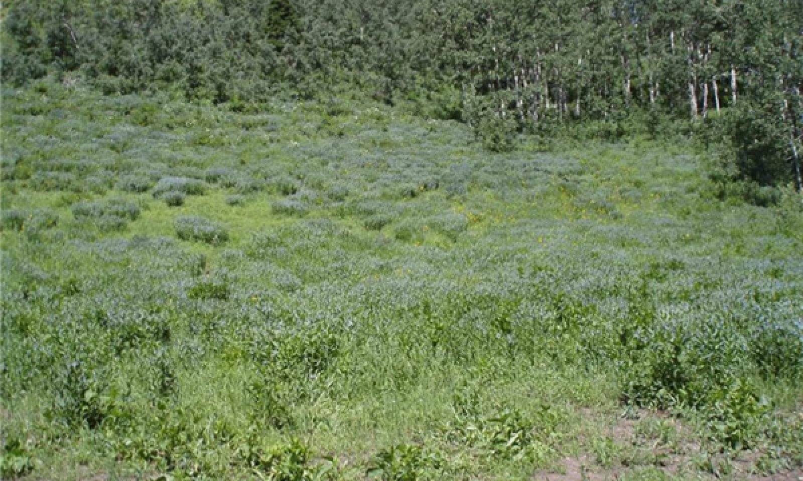
Tallforb, Cool season perennial grasses, Deciduous shrubsTall forbs, perennial cool-season grasses, and some deciduous shrubs with mountain snowberry being the most common: This is the community that is described in the initial plant List. The fact that you will not find any species of sagebrush on the site and more tall forbs than grasses during the summer months are key identifying characteristics for this site. This community is represented with a mean plant community of 25 percent grasses, 70 percent Forbs and 5 percent Shrubs. One of the dominant forbs visually and in production is Tall bluebell, the dominant grass is Mountain brome and the dominant shrub visually is mountain snowberry. This community is strong enough to only have around 10 to 15 percent bare ground and surface rock fragments. This site will remain in phase 1.1 so long as the site continues to have the normal 80 to 100 year fires that are associated with the surrounding quaking aspen sites and there are no prolonged disturbances.
Figure 7. Annual production by plant type (representative values) or group (midpoint values)
Table 5. Annual production by plant type
Plant type Low
(lb/acre)Representative value
(lb/acre)High
(lb/acre)Forb 700 1800 2050 Grass/Grasslike 250 550 700 Shrub/Vine 150 200 250 Total 1100 2550 3000 Table 6. Canopy structure (% cover)
Height Above Ground (ft) Tree Shrub/Vine Grass/
GrasslikeForb <0.5 0% 0% 1-5% 5-8% >0.5 <= 1 – 0% 3-5% 5-10% >1 <= 2 – 0-5% 10-15% 10-20% >2 <= 4.5 – 10-15% 1-9% 45-75% >4.5 <= 13 – 5-10% – – >13 <= 40 – – – – >40 <= 80 – – – – >80 <= 120 – – – – >120 – – – – Community 1.2
Cool-season perennial bunchgrasses, Tall forbs, Deciduous shrubsCool-season perennial bunchgrasses, tall forbs, and some deciduous shrubs make up this phase in the Reference State. This phase shows the results of overuse by large herbivores and small ungulates when the tall forbs have been damaged and grasses are allowed to gain a stronger place in the community. This community is represented with a mean plant community of 40 percent grasses, 35 percent tall forbs, 15 percent mid-stature forbs and 10 percent deciduous shrubs. This community will have around 15 to 20 percent bare ground and surface rock fragments.
Community 1.3
Tall and mid-stature forbs, Deciduous shrubs, Cool-season perennial bunchgrassesSite has been overused by grazing to the point that the mid-height forbs and deciduous shrubs have the advantage on the site at this point in time. This community is represented with a mean plant community of 20 percent grasses, 35 percent tall forbs, 20 percent mid-height forbs and 25 percent deciduous shrubs. This community will have around 15 to 25 percent bare ground and surface rock fragments.
State 2
Current Potential StateThis state includes the biotic communities that would become established on the ecological site if all successional sequences were completed without interferences by man under the present environmental conditions. Natural disturbances are inherent in its development. The Current Potential State (CPS) will include acclimatized, naturalized or invasive non-native species. There is no known way to effectively remove these plants from the site once they have become established. The level of occurrence of these plants in the CPS is such that careful management can prevent their domination of the site. This site is under normal circumstances considered an irreversibly changed. Plant communities within the CPS state may be managed and used for various purposes by man without significant alteration in plant community composition or production. It includes all of the plant communities that exist in the RPC state with the inclusion of species that are non-native to this ESD. These non-native plants are not to be considered when considering plants for the rangeland health site evaluation.
All of these scenarios are very interrelated and dependent on weather patterns and events as well as fire frequency and intensity and also the amount and intensity of large and small herbivore use. Any set of events that are strong enough to force the plant community out of this pattern can push it over a threshold and push it into another state.Community 2.1
Tall forbs, Cool-season perennial bunchgrasses, Deciduous shrubs, Introduced tall forbs
Figure 8. R047XA557UT State 2 Phase 2.1
Tall forbs, perennial cool-season bunchgrasses, and some deciduous shrubs, mountain snowberry being the most common, is the community that is described in the initial plant list. The fact that you will not find any species of sagebrush on the site and more tall forbs than grasses during the summer months are key identifying characteristics for this site. This community is represented with a mean plant community of 25 percent grasses, 70 percent forbs and 5 percent shrubs. One of the dominant forbs visually and in production is tall bluebell, the dominant grass is mountain brome and the dominant shrub, visually, is mountain snowberry, along with any introduced or invasive plant species. This community is strong enough to only have around 10 to 15 percent bare ground and surface rock fragments.
Community 2.2
Cool-season perennial bunchgrasses, Tall forbs, Deciduous shrubs, Introduced tall forbsCool-season perennial bunchgrasses, tall forbs and some deciduous shrubs make up this phase in the Reference State. This phase shows the results of overuse by large herbivores and small ungulates when the tall forbs have been damaged and grasses are allowed to gain a stronger place in the community. This community is represented with a mean plant community of 40 percent grasses, 35 percent tall forbs, 15 percent mid-stature forbs and 10 percent deciduous shrubs along with any introduced and/or invasive plant species. This community will have around 15 to 20 percent bare ground and surface rock fragments.
Community 2.3
Tall and mid-stature forbs, Deciduous shrubs, Cool-season perennial bunchgrass, Introduced tall fobsSite has been overused by grazing to the point that the mid-stature forbs and deciduous shrubs have the advantage on the site at this point in time. This community is represented with a mean plant community of 20 percent grasses, 35 percent tall forbs, 20 percent mid-stature forbs and 25 percent deciduous shrubs along with any introduced and/or invasive plant species. This community will have around 15 to 25 percent bare ground and surface rock fragments.
State 3
Grassy StateThis state is the condition of the site when grazing and other factors damage the forb plant community. It will have a visual and production dominance of grasses, followed by deciduous shrubs and then by those native tall and mid-height forbs and introduced forbs. The community will be 40 percent grasses, 35 percent deciduous shrubs, and 25 percent forbs. At this time forbs like Western coneflower move to the forefront in the forb community. It appears that this community can exist for an extended period of time until environmental conditions set the stage to move back to the more stable state found in the ”Current Potential State”.
Community 3.1
Cool-season perennial bunchgrass, Deciduous shrubs, Tall and mid-stature native and introduced forbsThe ecological site will transition to this state when overgrazed until the site does not have the resources to move back to any of the phases in State 2.
State 4
Eroded StateThis is the state that exists when the site has deteriorated to the point where so much of the top soil has eroded away the site can no longer produce the plant community and support the production that it had in the “Reference or Current Potential States” It will often be represented with 15 percent mid-stature grasses, 25 percent short-statured grasses, 35 percent deciduous shrubs, 15 percent mid-stature forbs and 10 percent tall forbs with the forbs being the grazing tolerant ones. At this state there will be twice as much bare ground and rock fragment visible as in the more productive states.
Community 4.1
Short- and mid-stature forbs and cool-season grass, Deciduous shrub, Tall cool-season grassShort- to mid-stature cool-season perennial grasses short- to mid-stature forbs deciduous shrubs perennial invasive plants annual invasive plants tall cool-season perennial grasses tall forbs. This state exists when the site has deteriorated to the point that a good share of the top soil has eroded away and the top horizons have been lost. Return to a previous state is not possible within management time frames. Often the site will have a gravelly surface that will resemble the windblown desert soil surface known as desert pavement. In this state the site is only about one-third to one-half as productive as in the Reference State.
Transition T1a
State 1 to 2Introduction of non-native species into the ecosystem.
Transition T2a
State 2 to 3Lack of fire disturbance and the overuse of the site by large ungulates. Prolonged Drought, Overgrazing, Extreme lengthening of the fire interval frequency. Also prolonged drought along with prolonged overgrazing can cause this condition into existence.
Restoration pathway R1a
State 3 to 2Time with proper management that favors the native plants as they increase on site and move back into the site.
Conservation practices
Prescribed Grazing Grazing Management Plan - Applied Transition T3a
State 3 to 4Prolonged overgrazing, coupled with drought; and extreme lengthening of the fire interval due to the overgrazing reducing and eliminating the community’s ability to carry fire leading to extreme accelerated erosion.
Additional community tables
Table 7. Community 1.1 plant community composition
Group Common name Symbol Scientific name Annual production () Foliar cover (%) Shrub/Vine0 Primary Grasses 250–500 mountain brome BRMA4 Bromus marginatus 250–375 – slender wheatgrass ELTR7 Elymus trachycaulus 125–250 – Grass/Grasslike0 Primary Forbs 500–1750 aspen bluebells MEAR6 Mertensia arizonica 625–1500 – western coneflower RUOC2 Rudbeckia occidentalis 375–625 – western yarrow ACMIO Achillea millefolium var. occidentalis 375–625 – sticky purple geranium GEVI2 Geranium viscosissimum 375–625 – Forb0 Primary Shrubs 100–250 mountain snowberry SYOR2 Symphoricarpos oreophilus 100–250 – Table 8. Community 1.2 plant community composition
Group Common name Symbol Scientific name Annual production () Foliar cover (%) Table 9. Community 1.3 plant community composition
Group Common name Symbol Scientific name Annual production () Foliar cover (%) Table 10. Community 2.1 plant community composition
Group Common name Symbol Scientific name Annual production () Foliar cover (%) Table 11. Community 2.2 plant community composition
Group Common name Symbol Scientific name Annual production () Foliar cover (%) Table 12. Community 2.3 plant community composition
Group Common name Symbol Scientific name Annual production () Foliar cover (%) Table 13. Community 3.1 plant community composition
Group Common name Symbol Scientific name Annual production () Foliar cover (%) Table 14. Community 4.1 plant community composition
Group Common name Symbol Scientific name Annual production () Foliar cover (%) Interpretations
Animal community
Animals – This site is home to Potgut (Uinta Ground Squirrel (Spermophilus armatus)), Pocket goffers (Thomomys bottal) and a seasonal home to Northern Goshawk (Accipiter gentilis, Mule Deer (Odocoileus hemionus), Elk (Cervus Canadensis., and Blue Grouse (Dendragapus obscurus.
Hydrological functions
The Hydrologic group is B
Recreational uses
Recreation activities are mostly aesthetic value due to the type of terrain and the size of the areas that this site encompasses. Hunting is a use in conjunction with surrounding areas.
Wood products
There are no wood products from this site.
Other products
Grazing of wildlife and livestock during summer months.
Supporting information
Inventory data references
Information presented here has been derived from NRCS clipping data and other inventory data. Field observations from range trained personnel were also used.
Other references
This field collected data is also backed by observations by a number of Forest Service research personal. Alma Winward being the main contact.
Galatowitsch, S.M. 1990. Using the original land survey notes to reconstruct pre-settlement landscapes in the American West. Great Basin Naturalist: 50(2): 181-191. Keywords: [Western U.S., conservation, history, human impact]
Parson, R. E. 1996. A History of Rich County. Utah State Historical Society, County Commission, Rich County, Utah. Keywords: [Rich County, Utah, Historic land use, European settlements]
USDA-NRCS. 2003. National Range and Pasture Handbook. in USDA, editor, USDA-Natural Resources Conservation Service-Grazing Lands Technology Institute. Keywords: [Western US, Federal guidelines, Range pasture management]Contributors
GBB
Approval
Kendra Moseley, 2/06/2025
Rangeland health reference sheet
Interpreting Indicators of Rangeland Health is a qualitative assessment protocol used to determine ecosystem condition based on benchmark characteristics described in the Reference Sheet. A suite of 17 (or more) indicators are typically considered in an assessment. The ecological site(s) representative of an assessment location must be known prior to applying the protocol and must be verified based on soils and climate. Current plant community cannot be used to identify the ecological site.
Author(s)/participant(s) Brock Benson (NRCS), Shane Green (NRCS) Contact for lead author Shane Green (NRCS) shane.green@ut.usda.gov Date 04/07/2014 Approved by Approval date Composition (Indicators 10 and 12) based on Annual Production Indicators
-
Number and extent of rills:
Number and extent of rills: None to few. Any rills present should be short in length (less than 1.5 feet long) and follow the surface micro-features. Old rills will weather quickly because of loamy surface textures. A slight increase in rill formation may be caused by major disturbance events such as severe thunderstorms and/or accelerated snow melt in spring. -
Presence of water flow patterns:
Presence of water flow patterns: Flow patterns around perennial plants bases will show minor evidence of erosion. They will be short (1 to 1.5 feet long) and look stable. There is slight evidence of deposition. -
Number and height of erosional pedestals or terracettes:
Plants should show slight (1/16 – 1/8 in.) pedestialing. Pedestialing on the down slope side of plants may appear to be greater than this and will be more visible as slopes increase. Terracettes should be absent until slopes are greater than 20 %. At this point the terracettes should look stable and have little to no visual evidence of soil being re-deposited. -
Bare ground from Ecological Site Description or other studies (rock, litter, lichen, moss, plant canopy are not bare ground):
(5 – 10 % on slopes up to 25 % and 10 – 15 % on slopes from 25 % up) -
Number of gullies and erosion associated with gullies:
: None. Any gullies present should show little sign of active erosion and should appear stable having perennial plants growing in the bottom and on the sides. -
Extent of wind scoured, blowouts and/or depositional areas:
None. Wind caused blowouts should not be present at all due to height of surrounding trees. -
Amount of litter movement (describe size and distance expected to travel):
Little redistribution can be caused by water. Very fine to fine litter movement may occur in water flow patterns with deposition occurring at points of obstruction. -
Soil surface (top few mm) resistance to erosion (stability values are averages - most sites will show a range of values):
80 to 90% of this site should have soil surfaces that are stabilized by organic matter both de-compositional and incorporated (Stability Class 6). This may be observable in that water flow patterns are not scoured to where the surface is visibly smoother than soil surfaces in non-flow pattern areas. -
Soil surface structure and SOM content (include type of structure and A-horizon color and thickness):
The A horizon is varies from 5 to 18 inches thick. Color is a dark brown gravelly loam (typical mollic colors). Structure should be granular. -
Effect of community phase composition (relative proportion of different functional groups) and spatial distribution on infiltration and runoff:
When perennial plant community is intact it will maintain the organic granular structure, soil porosity, and sinuous water flow paths that allows water to infiltrate at a rate that will not lend to water leaving the site. If the plant community has been degraded then the site will show longer and/or smoother than expected water flow patterns. -
Presence and thickness of compaction layer (usually none; describe soil profile features which may be mistaken for compaction on this site):
There should be no compaction layer. The amount of gravel may make it hard to use a probe effectively to determine this. -
Functional/Structural Groups (list in order of descending dominance by above-ground annual-production or live foliar cover using symbols: >>, >, = to indicate much greater than, greater than, and equal to):
Dominant:
Tall forbs (aspen bluebell, western coneflower, western yarrow, sticky purple geranium) > perennial grasses (mountain brome, slender wheatgrass) >> deciduous shrub (mountain snowberry).Sub-dominant:
Tall forbs (towering jacob''''s ladder, tall larkspur, aspen pea) > perennial grasses (columbia needlegrass, columbia brome, oniongrass) >>deciduous shrubs (red elderberry, gooseberry currant).Other:
A wide variety of other perennial forbs will be found in this plant community.Additional:
Assumed fire cycle of 80 to 100 years. The perennial bunchgrass about 15 to 30 %; tall forbs 55 to 80% and 0 to 10% deciduous shrubs (composition by biomass) functional groups are expected on this site. -
Amount of plant mortality and decadence (include which functional groups are expected to show mortality or decadence):
All age classes (seedling, immature, mature, and decadent) of Tall Forbs and perennial bunchgrasses should be present. The % of decadent and/or dead plants should not exceed 5 %. -
Average percent litter cover (%) and depth ( in):
This plant community should have a notable amount of litter due to th high production amounts and the fact that most of the production is forbs. -
Expected annual annual-production (this is TOTAL above-ground annual-production, not just forage annual-production):
2000 - 2500 lb./acre under normal growing conditions. -
Potential invasive (including noxious) species (native and non-native). List species which BOTH characterize degraded states and have the potential to become a dominant or co-dominant species on the ecological site if their future establishment and growth is not actively controlled by management interventions. Species that become dominant for only one to several years (e.g., short-term response to drought or wildfire) are not invasive plants. Note that unlike other indicators, we are describing what is NOT expected in the reference state for the ecological site:
As ecological condition deteriorates due to outside disturbances, Tall bluebell decrease while less desirable plants like Tall larkspur, and Western coneflower increase along with invasive plants like London rocket and Queen Ann’s Lace -
Perennial plant reproductive capability:
All plants should have the ability to reproduce either by seed and/or vegetative tillers in all years, except after prolonged extreme drought years.
Print Options
Sections
Font
AAAAOther
PrintThe Ecosystem Dynamics Interpretive Tool is an information system framework developed by the USDA-ARS Jornada Experimental Range, USDA Natural Resources Conservation Service, and New Mexico State University.
Accessibility statement