
Natural Resources
Conservation Service
Ecological site R047XA316UT
Upland Shallow Loam
(black sagebrush)
Last updated: 2/05/2025
Accessed: 10/16/2026
-
Search


Major Land Resource Area or ecological site by name and/or ID.
PreviousSectionsNextGeneral information
Provisional. A provisional ecological site description has undergone quality control and quality assurance review. It contains a working state and transition model and enough information to identify the ecological site.
MLRA notes
Major Land Resource Area (MLRA): 047X–Wasatch and Uinta Mountains
MLRA 47 occurs in Utah (86 percent), Wyoming (8 percent), Colorado (4 percent), and Idaho (2 percent). It encompasses approximately 23,825 square miles (61,740 square kilometers). The northern half of this area is in the Middle Rocky Mountains Province of the Rocky Mountain System. Parts of the western edge of this MLRA are in the Great Basin Section of the Basin and Range Province of the Intermontane Plateaus. The MLRA includes the Wasatch Mountains, which trend north and south. The steeply sloping, precipitous Wasatch Mountains have narrow crests and deep valleys. Active faulting and erosion are a dominant force in controlling the geomorphology of the area.
The mountains in this area are primarily fault blocks that have been tilted up. Alluvial fans at the base of the mountains are recharge zones for the basin fill aquifers. An ancient shoreline of historic Bonneville Lake is evident on the footslopes along the western edge of the area. Rocks exposed in the mountains are mostly Mesozoic and Paleozoic sediments.
The average precipitation is from 12 to 16 inches in the valleys and can range up to 73 inches in the mountains. Peak precipitation occurs in the winter months. The average annual temperature is 30 to 50 degrees F (-1 to 15 C). The freeze-free period averages 140 days and ranges from 60 to 220 days, generally decreasing in length with elevation.
The dominant soil orders in this MLRA are Entisols, Inceptisols, and Mollisols. The lower elevations are dominated by a frigid temperature regime, while the higher elevations experience cryic temperature regimes. The soil moisture regime is typically xeric. The minerology is generally mixed and the soils are very shallow to very deep, generally well drained, and loamy or loamy –skeletal.LRU notes
This LRU includes the Wasatch Mountains which tend to run north and south. These steeply sloping, precipitous mountains have narrow crests and deep valleys. They are primarily fault blocks that have been tilted up. The alluvial fans located at the base of these mountains are important recharge zones for valley aquifers.
Ecological site concept
This site occurs on foothills, mountain slopes and hills at elevations between 6,500 and 8,500 feet. This site typically has a restrictive bedrock layer around 20 inches below the soil surface. The dominant aspect of this ecological site in reference condition is black sagebrush with a diverse perennial forb community and perennial bunchgrasses.
Associated sites
R047XA332UT Upland Stony Loam (black sagebrush)
This site is found in association with the upland shallow loam site in soils that are stony and deeper than 20 inches.
Similar sites
R047XA301UT Upland Clay Loam (early sagebrush)
This site is dominated by early sagebrush and the surface texture is a clay loam.
Table 1. Dominant plant species
Tree Not specified
Shrub (1) Artemisia nova
Herbaceous (1) Pseudoroegneria spicata
Physiographic features
This site occurs on foothills, mountain slopes and hills at elevations between 5,100 and 7,500 feet. Slopes mostly range from 10 to 50 percent, but may vary from 2 to 70 percent. Flooding and ponding do not occur on this site, and it does not have a water table.
Table 2. Representative physiographic features
Landforms (1) Mountain slope
(2) Ridge
(3) Hill
Flooding frequency None Ponding frequency None Elevation 5100 – 7500 ft Slope 10 – 50 % Aspect Aspect is not a significant factor Table 3. Representative physiographic features (actual ranges)
Flooding frequency Not specified Ponding frequency Not specified Elevation 0 ft Slope 2 – 70 % Climatic features
The climate of this site is characterized by cold, snowy winters and hot dry summers. The average annual precipitation is between 12 and 16 inches, but in some cases can reach as high as 20 inches. Winter snowpack adds moisture to the soil as it melts in the spring. However, much of the spring moisture is unavailable to plants by mid-June and reduced precipitation causes many herbaceous species to go dormant by early July. June, July and August are commonly the driest months. Plant growth usually begins from March 15th to April 15th and grasses and forbs usually mature from June 15th to July 1st due to soil moisture deficiencies and hot temperatures. The optimal growing period is from early May to early June. Shrubs usually grow throughout July and August but at a much reduced rate and continue into October. Grasses usually green up again in late August through October in areas that are influenced by the summer monsoonal rains.
Table 4 Representative climatic features
Frost-free period (characteristic range) 80 days Freeze-free period (characteristic range) 120 days Precipitation total (characteristic range) 10 in Frost-free period (actual range) 80 days Freeze-free period (actual range) 120 days Precipitation total (actual range) 10 in Frost-free period (average) 80 days Freeze-free period (average) 120 days Precipitation total (average) 10 in Characteristic rangeActual rangeBarLineFigure 1. Monthly precipitation range
Characteristic rangeActual rangeBarLineFigure 2. Monthly minimum temperature range
Characteristic rangeActual rangeBarLineFigure 3. Monthly maximum temperature range
BarLineFigure 4. Monthly average minimum and maximum temperature
Figure 5. Annual precipitation pattern
Figure 6 Annual average temperature pattern
Climate stations used
-
(1) LAKETOWN [USC00424856], Laketown, UT
">Influencing water features
Due to its landscape position, this site is not typically influenced by streams or wetlands.
Soil features
The soils of this site are shallow to bedrock and formed in colluvium, slope alluvium and residuum derived from limestone or conglomerate rock. Bedrock is typically 10-20 inches below the soil surface. Surface textures are occasionally loams, but are often gravelly or cobbly with greater than 35 percent rock fragments by volume. These soils are somewhat excessively drained with moderate or moderately rapid permeability. Available water-holding capacity is restricted by the shallow nature of the soil, and ranges from 1.0 to 2.1 inches of water throughout the profile. These soils can be non-calcareous to very calcareous and have neutral to alkaline pH. The soil moisture regime is xeric and the soil temperature regime can be mesic or frigid.
Soil surveys correlated to this site:
Rich County, Utah: Highams (RBD, RBE), Solak (SHF)
Cache Valley Area: Richmond (RCG2, RDG2, REG2, RFG2, RGG2)Table 5. Representative soil features
Parent material (1) Colluvium – calcareous conglomerate
(2) Alluvium – limestone
(3) Residuum – limestone
Surface texture (1) Gravelly loam
(2) Very cobbly loam
(3) Loam
Family particle size (1) Loamy-skeletal
Drainage class Well drained to somewhat excessively drained Permeability class Moderate to moderately rapid Depth to restrictive layer 10 – 20 in Soil depth 10 – 20 in Surface fragment cover <=3" 17 – 24 % Surface fragment cover >3" 2 – 33 % Available water capacity
(0-40in)1 – 2.1 in Calcium carbonate equivalent
(0-40in)5 – 55 % Electrical conductivity
(0-40in)0 – 2 mmhos/cm Sodium adsorption ratio
(0-40in)0 – 5 Soil reaction (1:1 water)
(0-40in)6.6 – 8.4 Subsurface fragment volume <=3"
(0-40in)19 – 47 % Subsurface fragment volume >3"
(0-40in)5 – 24 % Table 6. Representative soil features (actual values)
Drainage class Not specified Permeability class Not specified Depth to restrictive layer 0 in Soil depth 0 in Surface fragment cover <=3" 7 – 24 % Surface fragment cover >3" 0 – 33 % Available water capacity
(0-40in)0 in Calcium carbonate equivalent
(0-40in)0 % Electrical conductivity
(0-40in)0 mmhos/cm Sodium adsorption ratio
(0-40in)0 Soil reaction (1:1 water)
(0-40in)0 Subsurface fragment volume <=3"
(0-40in)0 % Subsurface fragment volume >3"
(0-40in)0 % Ecological dynamics
It is impossible to determine in any quantitative detail the historic climax plant community (HCPC) for this ecological site because of the lack of direct historical documentation preceding all human influence. In some areas, the earliest reports of dominant plants include the cadastral survey conducted by the General Land Office, which began in the late 19th century for this area (Galatowitsch 1990). However, up to the 1870s the Shoshone Indians, prevalent in northern Utah and neighboring states, grazed horses and set fires to alter the vegetation for their needs (Parson 1996). In the 1860s, Europeans brought cattle and horses to the area, grazing large numbers of them on unfenced parcels year-long (Parson 1996). Itinerant and local sheep flocks followed, largely replacing cattle as the browse component increased.
Below is a State and Transition Model diagram to illustrate the “phases” (common plant communities), and “states” (aggregations of those plant communities) that can occur on the site. Differences between phases and states depend primarily upon observations of a range of disturbance histories in areas where this ESD is represented. These situations include grazing gradients to water sources, fence-line contrasts, patches with differing dates of fire, herbicide treatment, tillage, etc. Reference State 1 illustrates the common plant communities that probably existed just prior to European settlement.
The major successional pathways within states, (“community pathways”) are indicated by arrows between phases. “Transitions” are indicated by arrows between states. The drivers of these changes are indicated in codes decipherable by referring to the legend at the bottom of the page and by reading the detailed narratives that follow the diagram. The transition between Reference State 1 and State 2 is considered irreversible because of the naturalization of exotic species of both flora and fauna, possible extinction of native species, and climate change. There may have also been accelerated soil erosion.
When available, monitoring data (of various types) were employed to validate more subjective inferences made in this diagram. See the complete files in the office of the State Range Conservationist for more detail.State and transition model
More interactive model formats are also available. View Interactive Models
Click on state and transition labels to scroll to the respective textEcosystem states
State 3 submodel, plant communities
State 4 submodel, plant communities
State 1
Reference StateThe Reference State is a description of this ecological site just prior to Euro-American settlement but long after the arrival of Native Americans. The description of the Reference State was determined by NRCS Soil Survey Type Site Location information and familiarity with rangeland relict areas where they exist. The least modified plant community (1.1) within the Reference State would have been a sagebrush-dominated stand with black sagebrush (Artemisia nova), mountain big sagebrush (Artemisia tridentate spp. vaseyana), and low sagebrush (Artemisia arbuscular) and associated bunch grasses such as bluebunch wheatgrass (Pseudoroegeneria spicata), Nevada bluegrass (Poa secunda) and Indian ricegrass (Achnatherum hymenoides). Forbs such as Arrowleaf balsamroot (Balsamorhiza sagittata), phlox (Phlox spp.), and milkvetch (Astragalus spp.). The shallow and soils would have accentuated the effects of drought and reduced the chances of fire altering this state. The reference plant community (1.1) would have been relatively stable with occasional use by wildlife. However, heavy utilization by bison, elk, and Native American horses on these sites (1.1a) would have depleted the grasses creating a near monoculture of black sagebrush (1.2). Heavy browsing by deer during the dormant season of black sagebrush (1.1b) would have created an herbaceous variant (1.3). Occasional very wet years during El Nino-Southern Oscillation periods could have caused temporary soil anoxia (West 2000) (1.1c) killing the sagebrush and allowing the forbs and grasses to dominate for a short time (1.3). Infestation of some insects and pathogens on sagebrush (1.1c) could have led to a similar result where the herbaceous species become temporarily dominant (1.3). The interaction of an unusually dry period and heavy utilization by all grazers (e.g. deer, bison, elk, and horses used by native American) (1.1d) would have removed the palatable species from the plant community while allowing unpalatable, shorter-lived species such as yellow rabbitbrush (Chrysothamnus viscidiflorus ssp. viscidiflorus), locoweed, and phlox to predominate (1.4). The depauperate black sagebrush (Artemisia nova) community (1.2) could have also shifted to the unpalatable short-lived shrub community phase (1.4) in areas that have sustained heavy browsing by deer (1.2b). Relatively rocky sites such as these typically would not have declined in overall cover or productivity. However, the portion that is palatable may have changed appreciably. . Each of the phases within State 1 could have returned to Community Phase 1.1 if climate conditions were within the normal range of variability and there was a release from heavy grazing and/or browsing pressure (1.2a, 1.3a, 1.4a). A more complete list of species by lifeform for the Reference State is available in the accompanying tables in the “Plant Community Composition by Weight and Percentage” section of this document.
Community 1.1
Black sagebrush/Sparse bunchgrasses & Perennial forbsThe least modified plant community within the Reference State would have been a black sagebrush-dominated stand with scattered mountain big sagebrush and associated bunch grasses, such as bluebunch wheatgrass, Indian ricegrass, Sandberg bluegrass and western wheatgrass. Rayless tansy aster, phlox sp., buckwheat sp., and locoweed would have been the commonly associated forbs.
Figure 7. Annual production by plant type (representative values) or group (midpoint values)
Table 7. Annual production by plant type
Plant type Low
(lb/acre)Representative value
(lb/acre)High
(lb/acre)Grass/Grasslike 455 975 1300 Shrub/Vine 175 375 500 Forb 70 150 200 Total 700 1500 2000 Table 8. Ground cover
Tree foliar cover 0% Shrub/vine/liana foliar cover 30-30% Grass/grasslike foliar cover 10-20% Forb foliar cover 0-10% Non-vascular plants 0% Biological crusts 0% Litter 20-40% Surface fragments >0.25" and <=3" 20-20% Surface fragments >3" 0-30% Bedrock 0% Water 0% Bare ground 30-50% Community 1.2
Depauperate Black sagebrushThis plant community would have developed under heavy continuous season-long grazing by bison, elk, and Native American horses. Heavy utilization of grasses would have created a near monoculture of black sagebrush.
Community 1.3
Bunchgrasses & Perennial forbs/ Sparse Black sagebrushThere are several environmental conditions that would have produced this plant community. Heavy browsing by deer would have resulted in an herbaceous-dominated variant because of the utilization of black sagebrush during the dormant season. Under the occasional very wet period associated with an El Nino-Southern Oscillation event, temporary soil anoxia could have developed (West 2000), killing the sagebrush and allowing the forbs and grasses to dominate for a short time. A similar plant community would have also developed following an outbreak of insects and pathogens where sagebrush was the dominant host.
Community 1.4
Unpalatable short-lived shrubs/Perennial forbsThis plant community would have developed under the combined effect of unusual drought conditions and heavy grazing by all grazers including deer, bison, elk, and Native American horses. Focused utilization would have reduced the palatable species while allowing the noxious, unpalatable, and shorter-lived species such as yellow rabbitbrush, locoweed, and phlox to predominate.
Pathway 1.1a
Community 1.1 to 1.2Heavy continuous season-long grazing by bison, elk, and Native American horses would have converted the Reference State to a depauperate black sagebrush community.
Pathway 1.1b
Community 1.1 to 1.3Heavy browsing by deer would have converted the Reference State to a plant community dominated by bunchgrasses and perennial forbs. An extremely wet period such as an El Nino-Southern Oscillation event and subsequent anoxic soil conditions would have converted the Reference State to a plant community dominated by bunchgrasses and perennial forbs. The same result would occur following a sudden insect (or other pathogen) outbreak on sagebrush.
Pathway 1.1c
Community 1.1 to 1.4The interaction of exceptionally dry climatic influences compounded by heavy continuous season-long grazing by all grazers including deer, bison, elk, and Native American horses, would have converted the Reference State to an unpalatable short-lived shrub & perennial forb plant community.
Pathway 1.2a
Community 1.2 to 1.1The absence of grazing would have allowed the native bunchgrasses and perennial forbs to return to the system converting it back to the Community Phase 1.1.
Pathway 1.2b
Community 1.2 to 1.4Heavy browsing by deer would have converted the depauperate black sagebrush community to an unpalatable short-lived shrub community phase.
Pathway 1.3a
Community 1.3 to 1.1A return to normal climate conditions and the absence of heavy browsing would have allowed black sagebrush to re-establish and convert back to the Community Phase 1.1.
Pathway 1.4a
Community 1.4 to 1.1A return to normal climate conditions followed by a prolonged reduction in grazing pressure would have allowed black sagebrush and native bunchgrasses to re-establish returning to the reference plant community 1.1.
State 2
Black Sagebrush/ Introduced Non-natives StateState 2 is identical to State 1 in form and function, with the exception of the presence of non-native plants and animals, possible extinctions of native species, and a different climate. State 2 is a description of the ecological site shortly following Euro-American settlement, which can be regarded as the current potential. The least modified plant community (2.1) within State 2 is a black sagebrush dominated stand with scattered mountain big sagebrush and low sagebrush and associated bunch grasses such as bluebunch wheatgrass Nevada bluegrass and Indian ricegrass Forbs such as Arrowleaf balsamroot phlox and milkvetch. A common non-native species in this state is cheatgrass. The generally shallow soils accentuate the effect of drought and reduce the chances of fires altering this state. This plant community is relatively stable under mixed use by wildlife and livestock. However, heavy utilization by bison, elk, horses, and domestic cattle on these sites during the growing season (2.1a) would deplete the grasses creating a near monoculture of black sagebrush (2.2). Heavy browsing by deer and sheep (2.1b) would create an herbaceous variant (2.3) because of year-round utilization of black sagebrush. Occasionally very wet years during El Nino-Southern Oscillation periods can cause temporary soil anoxia (West 2000) (2.1c) killing the sagebrush and allowing the forbs and grasses to dominate for a short time (2.3). Some insects and pathogens on sagebrush (2.1c) can lead to a similar result where the herbaceous species become temporarily dominant (2.3). The interaction of an unusually dry period and heavy utilization of grasses by bison, elk, horses, and domestic cattle (2.1d) would remove the palatable species from the plant community while allowing unpalatable, shorter-lived species such as yellow rabbitbrush, locoweed, and phlox to predominate. Species composition does not change, just their abundance (2.4). The depauperate black sagebrush community (2.2) may also shift to the unpalatable short-lived shrub community phase (2.4) with heavy utilization of browse by deer and sheep (2.2b). Relatively shallow sites such as these typically do not decline in overall cover or productivity, however, the portion that is palatable may change appreciably. Each of the phases within State 2 can return to Community Phase 2.1 when climate conditions are within the normal range of variability and grazing pressure is moderated (2.2a, 2.3a, 2.4a).
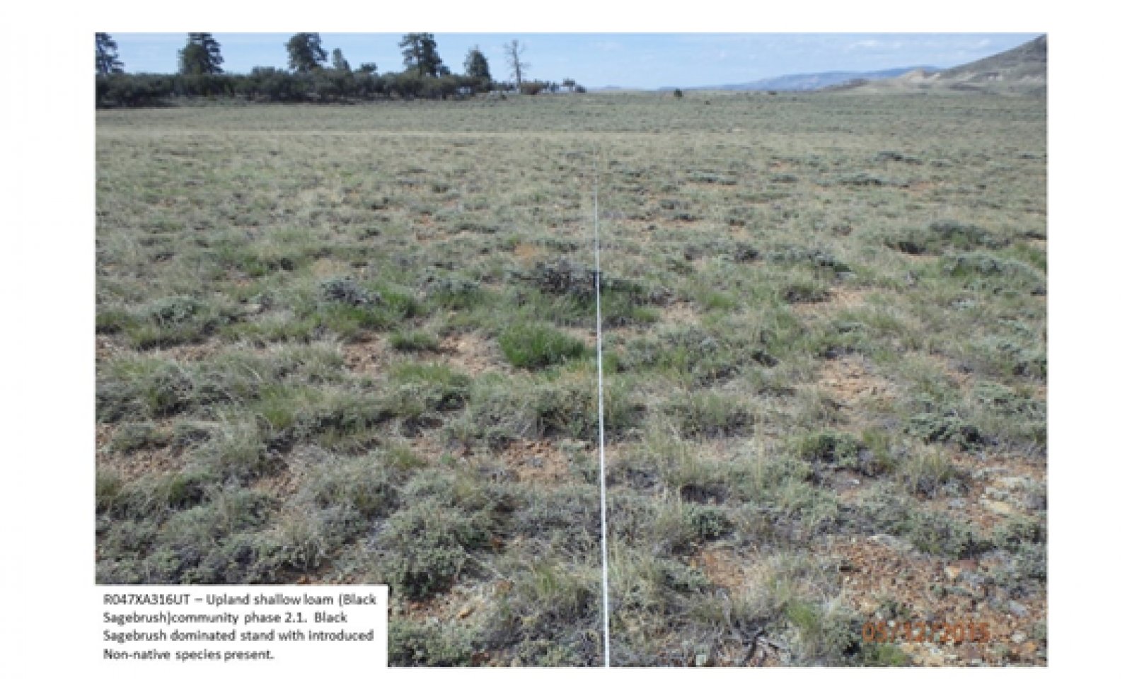
Community 2.1
Black sagebrush/Sparse bunchgrasses & Perennial forbs
Figure 8. CP2.1
The least modified plant community within the Black Sagebrush/ Introduced Non-natives State is a black sagebrush-dominated stand with scattered prickly pear and associated bunch grasses such as bluebunch wheatgrass, Indian ricegrass, Sandberg bluegrass, muttongrass, and bottlebrush squirreltail. Phlox, buckwheat, locoweed, and common yarrow are commonly associated forbs.
Community 2.2
Depauperate Black sagebrushThis plant community is developed under heavy continuous season-long grazing by bison, elk, cattle, and horses. Heavy utilization of grasses creates a near monoculture of black sagebrush. Some areas currently in this phase, and under tighter management of livestock and wildlife may be recovering, but are still in a phase depauperate in herbaceous understory compared to Community Phase 2.1.
Community 2.3
Bunchgrasses & Perennial forbs/ Sparse Black sagebrush
Figure 9. CP2.3
There are several environmental conditions that would produce this plant community. Heavy year-round browsing by deer and sheep would result in an herbaceous-dominated variant because of the utilization of black sagebrush. Following the occasional very wet period associated with an El Nino-Southern Oscillation event, temporary soil anoxia could develop, (West 2000) killing the sagebrush and allowing the forbs and grasses to dominate for a short time. A similar plant community would also develop following an outbreak of insects and pathogens where sagebrush is the dominant host.
Community 2.4
Unpalatable short-lived shrubs/Perennial forbsThis plant community is developed under extreme drought conditions combined with heavy continuous season-long grazing. Such disturbances will reduce the palatable species and allow the unpalatable, shorter-lived species such as yellow rabbitbrush, locoweed, and phlox to predominate. Because of the prevalence of historic unrestricted ungulate grazing, this is the most likely of the phases within State 2 to transition to States 3 or 4.
Pathway 2.1a
Community 2.1 to 2.2Heavy continuous season-long grazing by bison, elk, horses, and cattle would convert the Black sagebrush/ Sparse bunchgrasses & Perennial forbs phase to a depauperate black sagebrush community.
Pathway 2.1b
Community 2.1 to 2.3
Black sagebrush/Sparse bunchgrasses & Perennial forbs
Bunchgrasses & Perennial forbs/ Sparse Black sagebrushHeavy browsing by deer and sheep would convert the Black sagebrush/ Sparse bunchgrasses & Perennial forbs phase to a plant community dominated by bunchgrasses and perennial forbs. An extremely wet period such as an El Nino-Southern Oscillation event and subsequent anoxic soil conditions would convert the sparse black sagebrush/ bunchgrasses & Perennial forbs phase to a plant community dominated by bunchgrasses and perennial forbs. The same result would be seen following a sudden insect (or other pathogen) outbreak on sagebrush.
Pathway 2.1c
Community 2.1 to 2.4Combination of extremely dry conditions and heavy continuous season long grazing by all grazers would convert the black sagebrush/sparse bunchgrass/perennial forbs to an unpalatable short-lived shrub and perennial forb plant community.
Pathway 2.2a
Community 2.2 to 2.1This plant community can move back towards the Black sagebrush/ Sparse bunchgrasses & Perennial forbs phase when grazing management, particularly of sheep, and use by deer, take place only during the non-growing season of the herbaceous component, along with broadcast re-seeding with native perennial forbs and grasses.
Pathway 2.2b
Community 2.2 to 2.4Heavy browsing by deer and sheep would convert the depauperate black sagebrush phase to the unpalatable short-lived shrub and perennial forb community.
Pathway 2.3a
Community 2.3 to 2.1
Bunchgrasses & Perennial forbs/ Sparse Black sagebrush
Black sagebrush/Sparse bunchgrasses & Perennial forbsThis plant community can move back to the Black sagebrush/ Sparse bunchgrasses & Perennial forbs phase with a return to normal climate conditions and when grazing by both livestock and wildlife is concentrated during the spring to put pressure on the herbaceous component, allowing the native woody component to re-establish.
Pathway 2.4a
Community 2.4 to 2.1A return to the Black sagebrush/ Sparse bunchgrasses & Perennial forbs phase is possible with a return to normal (or wetter) climate conditions and high intensity short duration grazing management to allow the native woody component to re-establish and decrease the competition by herbaceous species.
State 3
Introduced Annuals/Biennials StateInvasive annuals and biennial forbs such as cheatgrass, Russian thistle, knapweeds, and horehound are favored by an increase in nutrient build-up in old, eutrophicated sheep bedgrounds. Where fire return intervals are frequent (3.2a) annuals such as cheatgrass and Russian thistle will predominate (3.1). Longer intervals between fire events (3.1a) will result in a plant community dominated by biennial forbs (3.2). The soil profiles of the plant communities within this state are mainly intact.
Community 3.1
Cheatgrass/Russian thistleThis plant community will develop where fire return intervals are frequent and annual species such as cheatgrass and Russian thistle predominate.
Community 3.2
Introduced forbsThis plant community will develop when intervals between fires are longer, allowing biennial species such as knapweeds, tumble mustard, and Dyer’s woad to become established.
Pathway 3.1a
Community 3.1 to 3.2When intervals between fire events are prolonged, biennial forbs will dominate the plant community.
Pathway 3.2a
Community 3.2 to 3.1When fire return intervals are frequent, annual forbs and grasses will dominate the plant community.
State 4
Seeded StateThis State occurs where historic excessive livestock grazing reduced canopy cover, and in an attempt to prevent any additional excessive erosion it was intentionally seeded with species such as smooth brome and/or crested wheatgrass.
Community 4.1
Seeded State
Figure 10. CP 4.1
This State occurs where historic excessive livestock grazing reduced canopy cover, and in an attempt to prevent any additional excessive erosion it was intentionally seeded with species such as smooth brome and/or crested wheatgrass. Do to the decreased canopy cover and increased erosion, and rangeland seeding is utilized, either rangeland drilled or aerial application with predominately introduced species.
Transition T1a
State 1 to 2The simultaneous introduction of exotic species, both plants and animals, and possible extinctions of native flora and fauna, along with climate change, will cause State 1 to transition to State 2. A return pathway back to State 1 would be impracticable because of these issues.
Transition T2a
State 2 to 3The Black Sagebrush/ Introduced Non-natives State will transition to the Introduced Annuals/Biennials State following a sustained period of excessive year-long livestock grazing, trampling and bedding, especially by large flocks of domestic sheep. Sheep bedding, salting, watering, and handling locations involve intensive trampling, urination and defecation. It is also common to see accelerated soil erosion in such locations.
Transition T3A
State 3 to 4A rangeland seeding, typically using introduced species.
Additional community tables
Table 9. Community 1.1 plant community composition
Group Common name Symbol Scientific name Annual production () Foliar cover (%) Grass/Grasslike0 Dominant Grasses 700–900 bluebunch wheatgrass PSSP6 Pseudoroegneria spicata 700–1000 – Sandberg bluegrass POSE Poa secunda 200–400 – 0 Sub-Dominant Grass 100–300 Grass, perennial 2GP Grass, perennial 50–100 – thickspike wheatgrass ELLA3 Elymus lanceolatus 50–100 – western wheatgrass PASM Pascopyrum smithii 50–100 – squirreltail ELEL5 Elymus elymoides 30–70 – sedge CAREX Carex 30–70 – Indian ricegrass ACHY Achnatherum hymenoides 25–50 – prairie Junegrass KOMA Koeleria macrantha 25–50 – spike fescue LEKI2 Leucopoa kingii 10–20 – needle and thread HECO26 Hesperostipa comata 10–20 – Idaho fescue FEID Festuca idahoensis 10–20 – Grass, annual 2GA Grass, annual 10–20 – Forb0 Dominant Forbs 50–100 arrowleaf balsamroot BASA3 Balsamorhiza sagittata 50–100 – 0 Sub-Dominant Forbs 50–100 lupine LUPIN Lupinus 30–70 – Forb, perennial 2FP Forb, perennial 30–70 – phlox PHLOX Phlox 30–70 – pussytoes ANTEN Antennaria 10–20 – western stoneseed LIRU4 Lithospermum ruderale 10–20 – tapertip hawksbeard CRAC2 Crepis acuminata 10–20 – Tolmie's owl's-clover ORTO Orthocarpus tolmiei 10–20 – pea LATHY Lathyrus 10–20 – Forb, annual 2FA Forb, annual 10–20 – milkvetch ASTRA Astragalus 10–20 – buckwheat ERIOG Eriogonum 10–20 – foothill deathcamas ZIPA2 Zigadenus paniculatus 10–20 – Shrub/Vine0 Dominant Shrubs 300–600 black sagebrush ARNO4 Artemisia nova 350–450 – big sagebrush ARTR2 Artemisia tridentata 50–350 – 0 Sub-Dominant Shrubs 50–100 antelope bitterbrush PUTR2 Purshia tridentata 50–100 – Shrub (>.5m) 2SHRUB Shrub (>.5m) 0–100 – yellow rabbitbrush CHVI8 Chrysothamnus viscidiflorus 30–60 – littleleaf horsebrush TEGL Tetradymia glabrata 10–20 – Table 10. Community 1.2 plant community composition
Group Common name Symbol Scientific name Annual production () Foliar cover (%) Table 11. Community 1.3 plant community composition
Group Common name Symbol Scientific name Annual production () Foliar cover (%) Table 12. Community 1.4 plant community composition
Group Common name Symbol Scientific name Annual production () Foliar cover (%) Table 13. Community 2.1 plant community composition
Group Common name Symbol Scientific name Annual production () Foliar cover (%) Table 14. Community 2.2 plant community composition
Group Common name Symbol Scientific name Annual production () Foliar cover (%) Table 15. Community 2.3 plant community composition
Group Common name Symbol Scientific name Annual production () Foliar cover (%) Table 16. Community 2.4 plant community composition
Group Common name Symbol Scientific name Annual production () Foliar cover (%) Table 17. Community 3.1 plant community composition
Group Common name Symbol Scientific name Annual production () Foliar cover (%) Table 18. Community 3.2 plant community composition
Group Common name Symbol Scientific name Annual production () Foliar cover (%) Table 19. Community 4.1 plant community composition
Group Common name Symbol Scientific name Annual production () Foliar cover (%) Interpretations
Animal community
This site is used by cattle and sheep during late spring, summer and fall. This site has high value for rangeland, but low values for woodland and wetland. Wildlife species that can be found on this site are sage grouse, antelope, mule deer, and elk.
Recreational uses
This site has fair to good aesthetic appeal and is valued for open space. In good condition it has a relatively large number of forbs and a few shrubs which bloom in the spring and early summer. It has very little value for screening because of the low growing nature of the plants and is not valued for camping and picnicking. Hiking, horseback riding, and wildlife viewing are potential recreational activities. Snowmobiling is a possible winter recreation activity, but this may conflict with large population of wintering mule deer, antelope and sage grouse.
Wood products
None.
Supporting information
Inventory data references
Galatowitsch, S. M. 1990. Using the original land survey notes to reconstruct pre-settlement landscapes in the American West. Great Basin Naturalist 50:181-191. Keywords: [Western U.S., conservation, history, human impact] Parson, R. E. 1996. A History of Rich County. Utah State Historical Society, County Commission, Rich County, Utah. Keywords: [Rich County, Utah, Historic land use, European settlements] USDA-NRCS. 2003. National Range and Pasture Handbook. in USDA, editor, USDA-Natural Resources Conservation Service-Grazing Lands Technology Institute. Keywords: [Western US, Federal guidelines, Range pasture management] West, N. E. 2000. Synecology and disturbance regimes of sagebrush steppe ecosystems. Pages 15-26 in Entwistle, P.G., A.M. DeBolt, J.H. Kaltenecker and K. Steenhof (compilers) Sagebrush Steppe Ecosystems Symposium Proceedings. Bureau of Land Management, Boise State University, Boise, Idaho, Publication No. BLM/ID/PT-0011001+1150. Keywords: [Intermountain West, Sagebrush Steppe, plant ecology, management] UDWR, Utah Big Game Range Trend Studies. 2007. Available at: https://dwrapps.utah.gov/rangetrend/rtstart Western Regional Climate Center, Western U.S. Climate Historical Summaries. Available at: https://wrcc.dri.edu/summary/Climsmut.html USDA-NRCS Official Soil Series Descriptions. Available at: https://soilseries.sc.egov.usda.gov/osdname.aspx
Contributors
M. Dean Stacy, NRCS
Lamar Mason, NRCSApproval
Kendra Moseley, 2/05/2025
Rangeland health reference sheet
Interpreting Indicators of Rangeland Health is a qualitative assessment protocol used to determine ecosystem condition based on benchmark characteristics described in the Reference Sheet. A suite of 17 (or more) indicators are typically considered in an assessment. The ecological site(s) representative of an assessment location must be known prior to applying the protocol and must be verified based on soils and climate. Current plant community cannot be used to identify the ecological site.
Author(s)/participant(s) Contact for lead author Date 10/16/2026 Approved by Approval date Composition (Indicators 10 and 12) based on Annual Production Indicators
-
Number and extent of rills:
-
Presence of water flow patterns:
-
Number and height of erosional pedestals or terracettes:
-
Bare ground from Ecological Site Description or other studies (rock, litter, lichen, moss, plant canopy are not bare ground):
-
Number of gullies and erosion associated with gullies:
-
Extent of wind scoured, blowouts and/or depositional areas:
-
Amount of litter movement (describe size and distance expected to travel):
-
Soil surface (top few mm) resistance to erosion (stability values are averages - most sites will show a range of values):
-
Soil surface structure and SOM content (include type of structure and A-horizon color and thickness):
-
Effect of community phase composition (relative proportion of different functional groups) and spatial distribution on infiltration and runoff:
-
Presence and thickness of compaction layer (usually none; describe soil profile features which may be mistaken for compaction on this site):
-
Functional/Structural Groups (list in order of descending dominance by above-ground annual-production or live foliar cover using symbols: >>, >, = to indicate much greater than, greater than, and equal to):
Dominant:
Sub-dominant:
Other:
Additional:
-
Amount of plant mortality and decadence (include which functional groups are expected to show mortality or decadence):
-
Average percent litter cover (%) and depth ( in):
-
Expected annual annual-production (this is TOTAL above-ground annual-production, not just forage annual-production):
-
Potential invasive (including noxious) species (native and non-native). List species which BOTH characterize degraded states and have the potential to become a dominant or co-dominant species on the ecological site if their future establishment and growth is not actively controlled by management interventions. Species that become dominant for only one to several years (e.g., short-term response to drought or wildfire) are not invasive plants. Note that unlike other indicators, we are describing what is NOT expected in the reference state for the ecological site:
-
Perennial plant reproductive capability:
Print Options
Sections
Font
AAAAOther
PrintThe Ecosystem Dynamics Interpretive Tool is an information system framework developed by the USDA-ARS Jornada Experimental Range, USDA Natural Resources Conservation Service, and New Mexico State University.
Accessibility statement


