Natural Resources
Conservation Service
Ecological site F047XA508UT
High Mountain Loam
(quaking aspen)
Last updated: 2/05/2025
Accessed: 07/17/2026
-
Search


Major Land Resource Area or ecological site by name and/or ID.
PreviousSectionsNextGeneral information
Provisional. A provisional ecological site description has undergone quality control and quality assurance review. It contains a working state and transition model and enough information to identify the ecological site.
Click to explore map
Figure 1. Mapped extent
Areas shown in blue indicate the maximum mapped extent of this ecological site. Other ecological sites likely occur within the highlighted areas. It is also possible for this ecological site to occur outside of highlighted areas if detailed soil survey has not been completed or recently updated.
MLRA notes
Major Land Resource Area (MLRA): 047X–Wasatch and Uinta Mountains
MLRA 47 occurs in Utah (86 percent), Wyoming (8 percent), Colorado (4 percent), and Idaho (2 percent). It encompasses approximately 23,825 square miles (61,740 square kilometers). The northern half of this area is in the Middle Rocky Mountains Province of the Rocky Mountain System. Parts of the western edge of this MLRA are in the Great Basin Section of the Basin and Range Province of the Intermontane Plateaus. The MLRA includes the Wasatch Mountains, which trend north and south. The steeply sloping, precipitous Wasatch Mountains have narrow crests and deep valleys. Active faulting and erosion are a dominant force in controlling the geomorphology of the area.
The mountains in this area are primarily fault blocks that have been tilted up. Alluvial fans at the base of the mountains are recharge zones for the basin fill aquifers. An ancient shoreline of historic Bonneville Lake is evident on the footslopes along the western edge of the area. Rocks exposed in the mountains are mostly Mesozoic and Paleozoic sediments.
The average precipitation is from 12 to 16 inches in the valleys and can range up to 73 inches in the mountains. Peak precipitation occurs in the winter months. The average annual temperature is 30 to 50 degrees F (-1 to 15 C). The freeze-free period averages 140 days and ranges from 60 to 220 days, generally decreasing in length with increasing elevation.
The dominant soil orders in this MLRA are Entisols, Inceptisols, and Mollisols. The lower elevations have a frigid temperature regime, while higher elevations experience a cryic temperature regimes. The soil moisture regime is xeric. The minerology is generally mixed and the soils are very shallow to very deep, well-drained, and loamy or loamy–skeletal.Ecological site concept
The soils of this site formed mostly in colluvium, slope alluvium, or till derived from various parent materials including sandstone, limestone, shale, quartzite, and conglomerate rocks. Surface soils are very dark and loamy in texture. Rock fragments may be present on the soil surface and throughout the profile, but make up less than 35 percent of the soil volume. Soils are moderately deep to very deep, well-drained, and have moderately slow to moderate permeability. pH is moderately acidic to neutral. Available water-holding capacity ranges from 3.1 to 7.1 inches of water in the upper 40 inches of soil. The soil moisture regime is mostly udic to xeric udic and the soil temperature regime is cryic.
Associated sites
R047XA510UT High Mountain Loam (bigtooth maple)
R047XA528UT High Mountain Stony Clay (slender wheatgrass)
R047XA560UT High Mountain Gravelly Loam (mountain big sagebrush)
F047XA512UT High Mountain Loam (Douglas-fir)
R047XA516UT High Mountain Loam (mountain big sagebrush)
R047XA517UT High Mountain Loam (silver sagebrush)
R047XA434UT Mountain Loam (shrub)
R047XY009ID Mountain Loam 18-22 PZ ACGRG/ARTRV/PSSP6
R047XY010ID High Mountain Loam 25-35 PZ ACSAG2/PHMA5/BRCA5
Similar sites
R047XA458UT Mountain Stony Loam (quaking aspen thicket)
F047XA531UT High Mountain Stony Loam (quaking aspen)
R047XA510UT High Mountain Loam (bigtooth maple)
Table 1. Dominant plant species
Tree (1) Populus tremuloides
Shrub (1) Symphoricarpos oreophilus
Herbaceous (1) Carex rossii
Physiographic features
The High Mountain Loam (Aspen) ecological site occurs on mountain slopes, mountains and glacial moraines. Slopes normally range from 10 to 60 percent but may occasionally be steeper. Slope steepness, aspect and elevation will influence the vegetative floristics of this site. The elevation ranges between 7,000 to 10,000 feet. Runoff is high to very high.
Table 2. Representative physiographic features
Landforms (1) Mountain slope
(2) Mountain
(3) Moraine
Runoff class High to very high Flooding frequency None Ponding frequency None Elevation 7000 – 10000 ft Slope 10 – 60 % Aspect Aspect is not a significant factor Table 3. Representative physiographic features (actual ranges)
Runoff class Medium to very high Flooding frequency Not specified Ponding frequency Not specified Elevation 6640 – 10650 ft Slope 2 – 70 % Climatic features
The climate is characterized by cold, snowy winters and cool summers. The average annual precipitation ranges from 24 to 34 inches. October thru April, are typically the wettest months with June thru August being the driest. The most reliable sources of moisture for plant growth are the snow that accumulates over the winter and spring rains. Summer thunderstorms are intermittent and sporadic in nature, and thus, are less reliable sources of moisture to support vegetative growth. The typical mean annual air temperature ranges from 31 to 45 degrees Fahrenheit.
Table 4 Representative climatic features
Frost-free period (characteristic range) Freeze-free period (characteristic range) Precipitation total (characteristic range) 20-30 in Frost-free period (average) Freeze-free period (average) Precipitation total (average) 30 in BarLineFigure 2. Monthly precipitation range
BarLineFigure 3. Monthly average minimum and maximum temperature
">Influencing water features
Due to its landscape position, this site is not typically influenced by streams or wetlands.
Wetland description
N/A
Soil features
The soils of the High Mountain Loam (Aspen) ecological site formed mostly in colluvium, slope alluvium, or till derived from various parent materials including sandstone, limestone, shale, quartzite, and conglomerate rocks. Surface soils are very dark and loamy in texture. Rock fragments may be present on the soil surface and throughout the profile, but make up less than 35 percent of the soil volume (in the top 24 inches). These soils are moderately deep to very deep, well-drained, and have moderately slow to moderate permeability. pH is moderately acidic to neutral. Available water-holding capacity ranges from 3.1 to 7.1 inches of water in the upper 40 inches of soil. The soil moisture regime is mostly udic with some xeric and the soil temperature regime can be frigid or cryic.
Soil Survey Area; Soil Components (not inclusive):
UT013-Duchesne Area: Aagard; Big Bug; Croydon; Millerlake; Senchert.
UT603-Cache Valley Area: Lucky Star
UT604-Rich County: Baird Hollow; Ercan, Flygare; Lucky star; Mult; Richens; Yeljack.
UT608-Morgan Area: Flygare
UT609-Morgan Area: Ercan; Flygare; Richens; Scave.
UT613-Summit Area: Skutum.
UT616-Carbon Area: Croydon, Senchert.
UT622-Heber Valley Area: Baird Hollow; Flygare; Hailman; Roundy.
UT623-Emery Area: Aagard.
Typical Soil Profile (Lucky Star):
Layer of matted leaves and twigs on the surface.
A-0-13 inches: very dark grayish brown gravelly silt loam; 30 percent gravel & cobbles; slightly acid.
E-13-35 inches: pink very cobbly fine sandy loam; 50 to 60 percent cobbles and gravel; moderately acid.
E/B-35-55 inches: light brown very cobbly fine sandy loam; 50 to 60 percent cobbles and gravel; moderately acid.
B/E-55-70 inches: reddish brown very cobbly sandy clay loam; 50 to 70 percent cobbles & gravel; slightly acid.
C-70-86 inches: light brown very cobbly loam; 50 to 70 percent cobbles & gravel; slightly acid.Table 5. Representative soil features
Parent material (1) Colluvium – sandstone
(2) Alluvium – limestone
(3) Till – quartzite
Surface texture (1) Loam
(2) Silt loam
(3) Gravelly silt loam
Family particle size (1) Fine-loamy
Drainage class Well drained Permeability class Moderately slow to moderate Soil depth 40 – 60 in Surface fragment cover <=3" 0 – 10 % Surface fragment cover >3" 0 – 5 % Available water capacity
(0-40in)3.1 – 7.1 in Calcium carbonate equivalent
(0-40in)Not specified Electrical conductivity
(0-40in)0 – 2 mmhos/cm Sodium adsorption ratio
(0-40in)0 – 5 Soil reaction (1:1 water)
(0-40in)5.6 – 7.3 Subsurface fragment volume <=3"
(0-24in)0 – 25 % Subsurface fragment volume >3"
(0-24in)0 – 20 % Table 6. Representative soil features (actual values)
Drainage class Not specified Permeability class Not specified Soil depth 0 in Surface fragment cover <=3" 0 – 24 % Surface fragment cover >3" 0 – 15 % Available water capacity
(0-40in)2.7 – 8.2 in Calcium carbonate equivalent
(0-40in)0 % Electrical conductivity
(0-40in)0 mmhos/cm Sodium adsorption ratio
(0-40in)0 Soil reaction (1:1 water)
(0-40in)5.1 – 7.8 Subsurface fragment volume <=3"
(0-24in)0 – 34 % Subsurface fragment volume >3"
(0-24in)0 – 33 % Ecological dynamics
The High Mountain Loam (Aspen) ecological site occurs in the Wasatch Mountains Unit of the Middle Rocky Mountains Province of the Rocky Mountain System and evolved under all the ecological conditions and the natural influences of native herbivory, fire and climate associated with that province. This site is usually found on high elevation mountain slopes and moraines. Species composition is dominated by a canopy of stable Aspen. A minor shrub layer may be present with common juniper and Saskatoon serviceberry. Mountain brome, Ross sedge, blue wildrye and fringed brome are common herbaceous species. A wide diversity of perennial forbs are also present.
High elevations, short growing season, and cobbly or gravelly soils, combined with steep slopes limit availability of this site for livestock grazing. Grazing is usually limited to mid and late season cattle grazing and to bands of sheep that quickly move through the site during the summer months.
Evidence indicates that this site historically maintained a fairly short fire return interval (80 to 100 years). Following a fire, aspen regeneration and herbaceous species may dominate the site for a period of years. Over time, aspen typically moves through several seral communities including seedling, sapling, pole, immature forest, mature forest and eventually to an old or over-mature forest type. Mature aspen are susceptible to pathogen and insect buildups, and if fire does not occur, they will eventually kill mature trees. Logging has been observed in some locations, but it is usually restricted to flatter slopes and easily accessible locations. Following logging events, the remaining young aspen will again move through the immature, mature and over-mature community stages.
As vegetative communities respond to changes caused by natural or manmade events that cause them to cross ecological thresholds, a return to previous states may not be possible. The amount of effort needed to affect desired vegetative shifts depends on the biotic and abiotic features present and the desired results.
The following state-and-transition model diagram depicts the most common plant communities found on this ecological site. It does not depict all the plant communities that can occur, but does show the most prevalent and repeatable. As more data are collected, some of these plant communities may be revised or removed, and new ones added. These descriptions capture the current knowledge and experience at the time of this revision.State and transition model
Custom diagramStandard diagram
More interactive model formats are also available. View Interactive Models
More interactive model formats are also available. View Interactive Models
Click on state and transition labels to scroll to the respective textT1A - This transitional pathway occurs when various disturbances such as road building, pipeline construction or fence-line clearing provides an opportunity for non-native species to become established. T2A - Timber logging and its associated activities, including road building and skid trail development, removes mature and over-mature aspen trees from the site and provides an opportunity for non-native species to increase. R3A - This restoration pathway occurs following logging activities when the site is allowed to recover naturally. State 1 submodel, plant communities
1.1B - This community pathway occurs when wildfire removes the aspen overstory. This event can be exacerbated by drought, insect damage or disease. 1.1A - This community pathway occurs when fire is excluded from the plant community for long periods of time. 1.2A - This community pathway occurs when fire is excluded from the plant community for long periods of time. 1.3A - This community pathway occurs when fire is excluded from the plant community for long periods of time. 1.3B - This community pathway occurs when wildfire removes the growing aspen overstory. This event can be exacerbated by drought, insect damage and disease. 1.4A - This community pathway occurs when insect damage or disease kills old trees and allows the community to return to a community phase 1.1 type with snags present. 1.4B - This community pathway occurs when wildfire removes the aspen overstory. This event can be exacerbated by drought, insect damage or disease. State 2 submodel, plant communities
2.1A - This community pathway occurs when fire is excluded from the plant community for long periods of time. 2.2A - This community pathway occurs when fire is excluded from the plant community for long periods of time. 2.3A - This community pathway occurs when fire is excluded from the plant community for long periods of time. 2.3B - This community pathway occurs when wildfire removes the growing aspen overstory. This event can be exacerbated by drought, insect damage and/or disease. 2.4B - This community pathway occurs when insect damage or disease kills old trees and allows the community to return to a community phase 2.1 type with snags present. 2.4A - This community pathway occurs when wildfire removes the growing aspen overstory. This event can be exacerbated by drought, insect damage and disease. State 3 submodel, plant communities
State 1
Reference StateThe Reference State describes the biotic communities that may become established on this ecological site if all successional sequences are completed under natural disturbance conditions. Species composition is dominated by mature or seral aspen community types. Shrubs are of minor importance in this state but species such as common juniper and Saskatoon serviceberry may be present. Mountain snowberry and alderleaf mountain mahogany are other common shrub species. Ross sedge, blue wildrye and fringed brome are dominant herbaceous species. A wide diversity of perennial forbs are also present.
Several seral communities are described in this reference state including those of open canopy, seedling, sapling, pole, immature forest, mature forest, and eventually to an old or over-mature forest type if fire is excluded for very long periods of time.
The primary disturbance mechanisms in this state are overstory canopy density, weather fluctuations, and fire, or lack of fire. The Reference State is self-sustaining and resistant to change beyond normal seral community types due to adaptation to natural disturbances and a high resilience following those disturbances. When natural disturbances such as fire do occur, the rate of recovery can be quite variable.
Reference State: Plant communities influenced by aspen canopy density, long-term weather fluctuations, and periodic fire.
Characteristics and indicators. Indicators: A community dominated by aspen with an understory of aspen reproduction and a few shrubs including snowberry, alderleaf mountain mahogany and Saskatoon serviceberry. The density of the overstory canopy determines the amount and composition of the other native perennial grasses, grass-likes and forbs that may be present. Feedbacks: Natural fluctuations in weather patterns that allow for a self-sustaining mix of aspen, shrubs and native grass and grass-like species in the community. Insect herbivory, more frequent fires, or other disturbances allow for the establishment of invasive species. At-risk Community Phase: All communities are at risk when native plants are stressed and nutrients become available for non-native plants to establish. Trigger: The establishment of non-native plant species.
Community 1.1
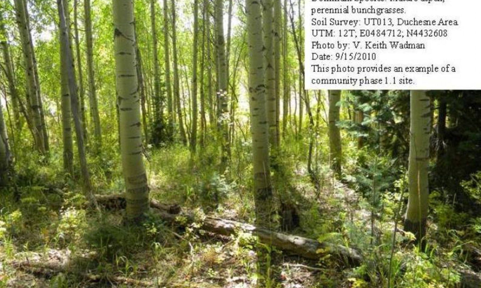
Mature Aspen Community Phase.
Figure 4. Community Phase 1.1
This community phase is dominated by an overstory canopy of mature aspen that have reached or are near maximal heights for the site. Average age is 80 to 120 years. Trees have developed tall, straight, clear stems with short, high rounded crowns. Tree canopy cover ranges from 20 to 40 percent. Understory vegetation is strongly influenced by tree competition, overstory shading, duff accumulation, etc. A few seedlings and saplings of quaking aspen occur in the understory. Shade tolerant plants such as blue wildrye, bearded wheatgrass, mountain brome, nodding bluegrass, sweet anise, meadowrue, and edible valerian are the dominant understory species.
Air dry composition of this site is approximately 25 percent grasses, 10 percent forbs, 10 percent shrubs and aspen reproduction and 65 mature aspen. Thick duff layers are present on some sites.
The following tables provide an example the typical vegetative floristics of a community phase 1.1 plant community.Figure 5. Annual production by plant type (representative values) or group (midpoint values)
Table 7. Annual production by plant type
Plant type Low
(lb/acre)Representative value
(lb/acre)High
(lb/acre)Tree 275 350 425 Grass/Grasslike 225 300 375 Forb 75 100 150 Shrub/Vine 75 100 125 Total 650 850 1075 Table 8. Ground cover
Tree foliar cover 40-50% Shrub/vine/liana foliar cover 10-10% Grass/grasslike foliar cover 20-30% Forb foliar cover 10-20% Non-vascular plants 0% Biological crusts 0% Litter 30-50% Surface fragments >0.25" and <=3" 0% Surface fragments >3" 0% Bedrock 0% Water 0% Bare ground 20-30% Table 9. Canopy structure (% cover)
Height Above Ground (ft) Tree Shrub/Vine Grass/
GrasslikeForb <0.5 15-25% 5-10% 15-20% 5-10% >0.5 <= 1 10-15% 5-10% 10-15% 5-10% >1 <= 2 5-10% 1-3% 2-5% 2-5% >2 <= 4.5 5-10% – – – >4.5 <= 13 5-10% – – – >13 <= 40 10-15% – – – >40 <= 80 20-30% – – – >80 <= 120 – – – – >120 – – – – Community 1.2
Aspen Seedling/ Herbaceous Community Phase.
Figure 6. Community Phase 1.2
This community phase is dominated by aspen sprouts and seedlings, and by perennial grasses and forbs under nearly full sunlight. This stage is experienced after a major disturbance such as crown fire, insect damage or disease. Any skeleton forest (dead trees) remaining have little or no affect on the composition and production of the herbaceous vegetation. Various amounts of tree seedlings 1 to 25 years old are present up to the point where they are obviously a major component of the vegetal structure. Ross sedge, Letterman's and Columbia needlegrass and California and fringed brome are important grass and grass-like species.
Air dry composition of this site is approximately 30 percent grasses, 15 percent forbs, 10 percent shrubs and and 55 aspen reproduction. Thick duff layers are present on some sites.
The following tables provide an example the typical vegetative floristics of a community phase 1.2 plant community.Figure 7. Annual production by plant type (representative values) or group (midpoint values)
Table 10. Annual production by plant type
Plant type Low
(lb/acre)Representative value
(lb/acre)High
(lb/acre)Tree 275 350 425 Grass/Grasslike 270 350 425 Forb 125 150 200 Shrub/Vine 75 100 125 Total 745 950 1175 Table 11. Ground cover
Tree foliar cover 40-50% Shrub/vine/liana foliar cover 10-10% Grass/grasslike foliar cover 20-30% Forb foliar cover 10-20% Non-vascular plants 0% Biological crusts 0% Litter 30-50% Surface fragments >0.25" and <=3" 0% Surface fragments >3" 0% Bedrock 0% Water 0% Bare ground 20-30% Table 12. Canopy structure (% cover)
Height Above Ground (ft) Tree Shrub/Vine Grass/
GrasslikeForb <0.5 15-25% 5-10% 15-20% 5-10% >0.5 <= 1 10-15% 5-10% 10-15% 5-10% >1 <= 2 5-10% 1-3% 2-5% 2-5% >2 <= 4.5 5-10% – – – >4.5 <= 13 – – – – >13 <= 40 – – – – >40 <= 80 – – – – >80 <= 120 – – – – >120 – – – – Community 1.3
Immature Aspen Forest/ Herbaceous Community Phase.
Figure 8. Community Phase 1.3
The Immature Aspen Forest/Herbaceous community phase is characterized by a growing canopy of pole sized and immature aspen. Trees are developing tall, straight, clear stems with narrow pointed crowns. Average age is 25 to 80 years. Tree canopy cover ranges from 10 to 20 percent. Understory vegetation is somewhat influenced by tree competition, overstory shading, duff accumulation, etc. Seedlings and saplings of quaking aspen are common in the understory. Shade tolerant plants such as blue wildrye, bearded wheatgrass, mountain brome, nodding bluegrass, sweet anise, meadowrue, and edible valerian are prominent in the understory.
Air dry composition of this site is approximately 20 percent grasses, 10 percent forbs, 10 percent shrubs and and 60 percent mature aspen. Thick duff layers are present on some sites.
The following tables provide an example the typical vegetative floristics of a community phase 1.3 plant community.Figure 9. Annual production by plant type (representative values) or group (midpoint values)
Table 13. Annual production by plant type
Plant type Low
(lb/acre)Representative value
(lb/acre)High
(lb/acre)Tree 275 350 425 Grass/Grasslike 225 300 375 Forb 75 100 150 Shrub/Vine 75 100 125 Total 650 850 1075 Table 14. Ground cover
Tree foliar cover 30-40% Shrub/vine/liana foliar cover 10-10% Grass/grasslike foliar cover 20-30% Forb foliar cover 10-20% Non-vascular plants 0% Biological crusts 0% Litter 30-50% Surface fragments >0.25" and <=3" 0% Surface fragments >3" 0% Bedrock 0% Water 0% Bare ground 20-30% Table 15. Canopy structure (% cover)
Height Above Ground (ft) Tree Shrub/Vine Grass/
GrasslikeForb <0.5 15-25% 5-10% 15-20% 5-10% >0.5 <= 1 10-15% 5-10% 10-15% 5-10% >1 <= 2 5-10% 1-3% 2-5% 2-5% >2 <= 4.5 5-10% – – – >4.5 <= 13 5-10% – – – >13 <= 40 10-15% – – – >40 <= 80 – – – – >80 <= 120 – – – – >120 – – – – Community 1.4
Decadent Aspen Community Phase.
Figure 10. Community Phase 1.4
This community phase is dominated by an overstory canopy of very mature and decadent aspen that have reached maximal heights. Average age is 120 plus years. Trees have developed tall, straight, clear stems with high, very rounded crowns. This phase typically develops in the absence of wildfire or other naturally occurring disturbances including disease and insect damage. Tree canopy cover is at a maximum for the site and is commonly greater than 50 percent. Very old trees often show signs of disease and insect damage. Understory vegetation is somewhat sparse due to tree competition, overstory shading, duff accumulation, etc. Shade tolerant plants such as blue wildrye, bearded wheatgrass, mountain brome, nodding bluegrass, sweet anise, meadowrue, and edible valerian are much reduced but may still be present in the understory.
Air dry composition of this site is approximately 5 percent grasses, 5 percent forbs, 10 percent shrubs and 70 percent aspen. Thick duff layers are often present, and completely covering the forest floor.
The following tables provide an example the typical vegetative floristics of a community phase 1.4 plant community.Figure 11. Annual production by plant type (representative values) or group (midpoint values)
Table 16. Annual production by plant type
Plant type Low
(lb/acre)Representative value
(lb/acre)High
(lb/acre)Tree 375 450 525 Grass/Grasslike 125 150 175 Forb 75 100 150 Shrub/Vine 75 100 125 Total 650 800 975 Table 17. Ground cover
Tree foliar cover 50-60% Shrub/vine/liana foliar cover 10-10% Grass/grasslike foliar cover 20-30% Forb foliar cover 10-20% Non-vascular plants 0% Biological crusts 0% Litter 30-50% Surface fragments >0.25" and <=3" 0% Surface fragments >3" 0% Bedrock 0% Water 0% Bare ground 20-30% Table 18. Canopy structure (% cover)
Height Above Ground (ft) Tree Shrub/Vine Grass/
GrasslikeForb <0.5 15-25% 5-10% 5-10% 5-10% >0.5 <= 1 10-15% 5-10% 5-10% 5-10% >1 <= 2 5-10% 1-3% 2-5% 2-5% >2 <= 4.5 5-10% – – – >4.5 <= 13 5-10% – – – >13 <= 40 10-15% – – – >40 <= 80 20-30% – – – >80 <= 120 15-20% – – – >120 – – – – Pathway 1.1B
Community 1.1 to 1.2
Mature Aspen Community Phase.
Aspen Seedling/ Herbaceous Community Phase.This community pathway occurs when wildfire removes the aspen overstory. This event can be exacerbated by drought, insect damage or disease.
Pathway 1.1A
Community 1.1 to 1.4
Mature Aspen Community Phase.
Decadent Aspen Community Phase.This community pathway occurs when fire is excluded from the plant community for long periods of time.
Pathway 1.2A
Community 1.2 to 1.3
Aspen Seedling/ Herbaceous Community Phase.
Immature Aspen Forest/ Herbaceous Community Phase.This community pathway occurs when fire is excluded from the plant community for long periods of time.
Pathway 1.3A
Community 1.3 to 1.1
Immature Aspen Forest/ Herbaceous Community Phase.
Mature Aspen Community Phase.This community pathway occurs when fire is excluded from the plant community for long periods of time.
Pathway 1.3B
Community 1.3 to 1.2
Immature Aspen Forest/ Herbaceous Community Phase.
Aspen Seedling/ Herbaceous Community Phase.This community pathway occurs when wildfire removes the growing aspen overstory. This event can be exacerbated by drought, insect damage and disease.
Pathway 1.4A
Community 1.4 to 1.1
Decadent Aspen Community Phase.
Mature Aspen Community Phase.This community pathway occurs when insect damage or disease kills old trees and allows the community to return to a community phase 1.1 type with snags present.
Pathway 1.4B
Community 1.4 to 1.2
Decadent Aspen Community Phase.
Aspen Seedling/ Herbaceous Community Phase.This community pathway occurs when wildfire removes the aspen overstory. This event can be exacerbated by drought, insect damage or disease.
State 2
Current Potential StateThe Current Potential State (2) is similar to the Reference State (1), however minor amounts of non-native species may now be present in all community phases. This condition has not been well documented and so community phases in this state are based on possible community dynamics and not documented facts. This State describes the biotic communities that may become established on the High Mountain Loam (Aspen) ecological site if all successional sequences are completed under natural disturbance conditions. Species composition is generally dominated by mature or seral aspen community types. Shrubs are of minor importance in this state but species such as common juniper and Saskatoon serviceberry may be present. Mountain snowberry and alderleaf mountain mahogany are other common shrub species. Ross sedge, blue wildrye and fringed brome are dominant herbaceous species. Non-native species such as smooth brome, Kentucky bluegrass and orchardgrass may also be present. A wide diversity of perennial forbs are also present.
Several seral communities are described in this state including those of open canopy, seedling, sapling, pole, immature forest, mature forest, and eventually to an old or over-mature forest type if fire is excluded for long periods of time.
The primary disturbance mechanisms in this state are overstory disturbance, canopy density, weather fluctuations, and fire, or lack of fire. The Current Potential State is still self-sustaining and resistant to change beyond it's normal seral community types due to adaptation to natural disturbances and a high resilience following those disturbances. When disturbances such as fire do occur, the rate of recovery can be quite variable.
Current Potential State: Plant communities influenced by aspen canopy density, long-term weather fluctuations, and periodic fire.
Characteristics and indicators. Indicators: A community dominated by aspen with an understory of aspen reproduction and a few shrubs including snowberry, alderleaf mountain mahogany and Saskatoon serviceberry. The density of the overstory canopy determines the amount and composition of the other non-native and native perennial grasses, grass-likes and forbs that may be present. Feedbacks: Natural fluctuations in weather patterns that allow for a self-sustaining mix of aspen, shrub and native grass and grass-like species in the community. Insect herbivory, more frequent fires, or other disturbances that may allow for the increase of non-native species. At-risk Community Phase: All communities are at risk when native plants are stressed and nutrients become available for non-native plants to increase. Trigger: The establishment of non-native plant species.
Community 2.1
Mature Aspen, Non-Native Herbaceous Community Phase.
Figure 12. Community Phase 2.1
The Mature Aspen, Non-native Herbaceous Community Phase is dominated by an overstory canopy of mature aspen that have reached or are near maximal heights for the site. Trees have developed tall, straight, clear stems with short, high rounded crowns. Tree canopy cover ranges from 20 to 40 percent. Understory vegetation is strongly influenced by tree competition, overstory shading, duff accumulation, etc. A few seedlings and saplings of quaking aspen occur in the understory. Shade tolerant plants such as blue wildrye, bearded wheatgrass, mountain brome, nodding bluegrass, sweet anise, meadowrue, and edible valerian are the dominant understory species. Non-native species, including smooth brome, orchardgrass, and Kentucky bluebrass, may be present in the community.
Air dry composition of this site is approximately 25 percent grasses, 10 percent forbs, 10 percent shrubs and aspen reproduction and 65 percent mature aspen. Thick duff layers are present on some sites.
The following tables provide an example of the typical vegetative floristics of a community phase 2.1 plant community.Figure 13. Annual production by plant type (representative values) or group (midpoint values)
Table 19. Annual production by plant type
Plant type Low
(lb/acre)Representative value
(lb/acre)High
(lb/acre)Tree 275 350 425 Grass/Grasslike 225 300 375 Forb 75 100 150 Shrub/Vine 75 100 125 Total 650 850 1075 Table 20. Ground cover
Tree foliar cover 40-50% Shrub/vine/liana foliar cover 10-10% Grass/grasslike foliar cover 20-30% Forb foliar cover 10-20% Non-vascular plants 0% Biological crusts 0% Litter 30-50% Surface fragments >0.25" and <=3" 0% Surface fragments >3" 0% Bedrock 0% Water 0% Bare ground 20-30% Table 21. Canopy structure (% cover)
Height Above Ground (ft) Tree Shrub/Vine Grass/
GrasslikeForb <0.5 15-25% 5-10% 15-20% 5-10% >0.5 <= 1 10-15% 5-10% 10-15% 5-10% >1 <= 2 5-10% 1-3% 2-5% 2-5% >2 <= 4.5 5-10% – – – >4.5 <= 13 5-10% – – – >13 <= 40 10-15% – – – >40 <= 80 20-30% – – – >80 <= 120 – – – – >120 – – – – Community 2.2
Aspen Seedling/ Non-Native Herbaceous Community Phase.
Figure 14. Community Phase 2.2
This community phase is dominated by aspen sprouts and seedlings, and by perennial grasses and forbs under nearly full sunlight. This stage is experienced after a major disturbance such as crown fire, insect damage or disease. Any skeleton forest (dead trees) remaining have little or no affect on the composition and production of the herbaceous vegetation. Various amounts of tree seedlings 1 to 25 years old are present up to the point where they are obviously a major component of the vegetal structure. Ross sedge, Letterman's and Columbia needlegrass and California and fringed brome are important grass and grass-like species. Non-native species including smooth brome, orchardgrass, and Kentucky bluegrass may also occur on the site.
Air dry composition of this site is approximately 30 percent grasses, 15 percent forbs, 10 percent shrubs and and 55 aspen reproduction. Thick duff layers are present on some sites.
The following tables provide an example the typical vegetative floristics of a community phase 2.2 plant community.Figure 15. Annual production by plant type (representative values) or group (midpoint values)
Table 22. Annual production by plant type
Plant type Low
(lb/acre)Representative value
(lb/acre)High
(lb/acre)Tree 275 350 425 Grass/Grasslike 270 350 425 Forb 125 150 200 Shrub/Vine 75 100 125 Total 745 950 1175 Table 23. Ground cover
Tree foliar cover 40-50% Shrub/vine/liana foliar cover 10-10% Grass/grasslike foliar cover 20-30% Forb foliar cover 10-20% Non-vascular plants 0% Biological crusts 0% Litter 30-50% Surface fragments >0.25" and <=3" 0% Surface fragments >3" 0% Bedrock 0% Water 0% Bare ground 20-30% Table 24. Canopy structure (% cover)
Height Above Ground (ft) Tree Shrub/Vine Grass/
GrasslikeForb <0.5 15-25% 5-10% 15-20% 5-10% >0.5 <= 1 10-15% 5-10% 10-15% 5-10% >1 <= 2 5-10% 1-3% 2-5% 2-5% >2 <= 4.5 5-10% – – – >4.5 <= 13 – – – – >13 <= 40 – – – – >40 <= 80 – – – – >80 <= 120 – – – – >120 – – – – Community 2.3
Immature Aspen Forest/Non-Native Herbaceous Community Phase.
Figure 16. Community Phase 2.3
The Immature Aspen Forest/Non-Native Herbaceous Community Phase is characterized by a growing canopy of pole sized and immature aspen. Trees are developing tall, straight, clear stems with narrow pointed crowns. Average age is 25 to 80 years. Tree canopy cover ranges from 10 to 20 percent. Understory vegetation is somewhat influenced by tree competition, overstory shading, duff accumulation, etc. Seedlings and saplings of quaking aspen are common in the understory. Shade tolerant plants such as blue wildrye, bearded wheatgrass, mountain brome, nodding bluegrass, sweet anise, meadowrue, and edible valerian are prominent in the understory. Non-native species including smooth brome. orchardgrass and Kentucky bluegrass are present in the community.
Air dry composition of this site is approximately 20 percent grasses, 10 percent forbs, 10 percent shrubs and and 60 percent mature aspen. Thick duff layers are present on some sites.
The following tables provide an example of the typical vegetative floristics of a community phase 2.3 plant community.Figure 17. Annual production by plant type (representative values) or group (midpoint values)
Table 25. Annual production by plant type
Plant type Low
(lb/acre)Representative value
(lb/acre)High
(lb/acre)Tree 275 350 425 Grass/Grasslike 225 300 375 Forb 75 100 150 Shrub/Vine 75 100 125 Total 650 850 1075 Table 26. Ground cover
Tree foliar cover 30-40% Shrub/vine/liana foliar cover 10-10% Grass/grasslike foliar cover 20-30% Forb foliar cover 10-20% Non-vascular plants 0% Biological crusts 0% Litter 30-50% Surface fragments >0.25" and <=3" 0% Surface fragments >3" 0% Bedrock 0% Water 0% Bare ground 20-30% Table 27. Canopy structure (% cover)
Height Above Ground (ft) Tree Shrub/Vine Grass/
GrasslikeForb <0.5 15-25% 5-10% 15-20% 5-10% >0.5 <= 1 10-15% 5-10% 10-15% 5-10% >1 <= 2 5-10% 1-3% 2-5% 2-5% >2 <= 4.5 5-10% – – – >4.5 <= 13 5-10% – – – >13 <= 40 10-15% – – – >40 <= 80 – – – – >80 <= 120 – – – – >120 – – – – Community 2.4
Decadent Aspen, Non-Native Herbaceous Community Phase.
Figure 18. Community Phase 2.4
This community phase is dominated by an overstory canopy of very mature and decadent aspen that have reached maximal heights for the site. Average age is 120 plus years. Trees have developed tall, straight, clear stems with high, very rounded crowns. This phase typically develops in the absence of wildfire or other naturally occurring disturbances including disease and insect damage. Tree canopy cover is at a maximum for the site and is commonly greater than 50 percent. Very old trees often show signs of disease and/or insect damage. Understory vegetation is somewhat sparse due to tree competition, overstory shading, duff accumulation, etc. Shade tolerant plants such as blue wildrye, bearded wheatgrass, mountain brome, nodding bluegrass, sweet anise, meadowrue, and edible valerian are much reduced but may still be present in the understory. Minor amounts of non-native species including smooth brome, orchardgrass and Kentucky bluegrass may be present on the community.
Air dry composition of this site is approximately 5 percent grasses, 5 percent forbs, 10 percent shrubs and 70 aspen. Thick duff layers are often present, completely covering the forest floor.
The following tables provide an example of the typical vegetative floristics of a community phase 2.4 plant community.Figure 19. Annual production by plant type (representative values) or group (midpoint values)
Table 28. Annual production by plant type
Plant type Low
(lb/acre)Representative value
(lb/acre)High
(lb/acre)Tree 375 450 525 Grass/Grasslike 125 150 175 Forb 75 100 150 Shrub/Vine 75 100 125 Total 650 800 975 Table 29. Ground cover
Tree foliar cover 50-60% Shrub/vine/liana foliar cover 10-10% Grass/grasslike foliar cover 20-30% Forb foliar cover 10-20% Non-vascular plants 0% Biological crusts 0% Litter 30-50% Surface fragments >0.25" and <=3" 0% Surface fragments >3" 0% Bedrock 0% Water 0% Bare ground 20-30% Table 30. Canopy structure (% cover)
Height Above Ground (ft) Tree Shrub/Vine Grass/
GrasslikeForb <0.5 15-25% 5-10% 5-10% 5-10% >0.5 <= 1 10-15% 5-10% 5-10% 5-10% >1 <= 2 5-10% 1-3% 2-5% 2-5% >2 <= 4.5 5-10% – – – >4.5 <= 13 5-10% – – – >13 <= 40 10-15% – – – >40 <= 80 20-30% – – – >80 <= 120 15-20% – – – >120 – – – – Pathway 2.1B
Community 2.1 to 2.2
Mature Aspen, Non-Native Herbaceous Community Phase.
Aspen Seedling/ Non-Native Herbaceous Community Phase.This community pathway occurs when wildfire removes the growing aspen overstory. This event can be exacerbated by drought, insect damage and/or disease.
Pathway 2.1A
Community 2.1 to 2.4
Mature Aspen, Non-Native Herbaceous Community Phase.
Decadent Aspen, Non-Native Herbaceous Community Phase.This community pathway occurs when fire is excluded from the plant community for long periods of time.
Pathway 2.2A
Community 2.2 to 2.3
Aspen Seedling/ Non-Native Herbaceous Community Phase.
Immature Aspen Forest/Non-Native Herbaceous Community Phase.This community pathway occurs when fire is excluded from the plant community for long periods of time.
Pathway 2.3A
Community 2.3 to 2.1
Immature Aspen Forest/Non-Native Herbaceous Community Phase.
Mature Aspen, Non-Native Herbaceous Community Phase.This community pathway occurs when fire is excluded from the plant community for long periods of time.
Pathway 2.3B
Community 2.3 to 2.2
Immature Aspen Forest/Non-Native Herbaceous Community Phase.
Aspen Seedling/ Non-Native Herbaceous Community Phase.This community pathway occurs when wildfire removes the growing aspen overstory. This event can be exacerbated by drought, insect damage and/or disease.
Pathway 2.4B
Community 2.4 to 2.1
Decadent Aspen, Non-Native Herbaceous Community Phase.
Mature Aspen, Non-Native Herbaceous Community Phase.This community pathway occurs when insect damage or disease kills old trees and allows the community to return to a community phase 2.1 type with snags present.
Pathway 2.4A
Community 2.4 to 2.2
Decadent Aspen, Non-Native Herbaceous Community Phase.
Aspen Seedling/ Non-Native Herbaceous Community Phase.This community pathway occurs when wildfire removes the growing aspen overstory. This event can be exacerbated by drought, insect damage and disease.
State 3
Logged/Disturbed StateThe Logged or Disturbed State is similar to the Current Potential State, however merchantable timber composed mostly of mature and old aspen have been removed. Various amounts of invasive species may also now be present in all community phases. This condition has not been well documented and so community phases in this State are based on possible community dynamics and not documented facts. Species composition is generally dominated by an immature canopy of aspen. Shrubs are of minor importance in the understory with common juniper, alderleaf mountain mahogany, mountain snowberry and Saskatoon serviceberry most often found. Ross sedge, blue wildrye and fringed brome are dominant herbaceous species. A wide diversity of perennial forbs are also present. Non-native species including orchardgrass, Kentucky bluegrass and smooth brome may also be present. These species could have been seeded as part of the site rehabilitation following the logging process.
Logging will release younger aspen trees and will give the site the look of an immature forest. Site will return to a mature, and finally an old or over-mature forest type if fire is excluded for very long periods of time.
The primary disturbance mechanisms are logging, road building or other man caused activities, weather fluctuations and fire or lack of fire. The logged state is still self-sustaining but has a lower resistance to change due to a reduced resistance to disturbances. When disturbances do occur, the rate of recovery can be highly variable.
Logged or Disturbed State: Plant communities influenced by man-caused activities, wildlife browsing, insect herbivory, weather fluctuations, fire periods and surface disturbances.
Characteristics and indicators. Indicators: A community dominated by immature aspen with an understory of aspen reproduction, and shrubs including common juniper, alderleaf mountain mahogany and Saskatoon serviceberry. The density of the overstory canopy determines the amount and composition of the other native and non-native perennial grasses, grass-likes and forbs that may be present. Feedbacks: Natural fluctuations in weather patterns that allow for a self-sustaining mix of a aspen, shrub and native grass and grass-like species in the community. Insect herbivory, more frequent fires, or other disturbances that may allow for the increase of non-native species. At-risk Community Phase: All communities are at risk when native plants are stressed and nutrients become available for non-native plants to increase. Trigger: The increase of non-native plant species.
Community 3.1
Logged Aspen Forest Community Phase.
Figure 20. Community Phase 3.1
This community phase is typically found following logging or other man caused activity such as road building or pipeline construction. It is characterized by a partial canopy of aspen. Pole and immature sized trees are present and are beginning to, once again, dominate the community. Shrubs are a minor component in the understory with common juniper and Saskatoon serviceberry occurring most often. Ross sedge, blue wildrye and fringed brome are dominant herbaceous species. A wide diversity of perennial forbs are also present. Non-native species including orchardgrass, Kentucky bluegrass and smooth brome may potentially also be found on the site. Understory vegetation is somewhat influenced by tree competition, overstory shading, duff accumulation, etc. Seedlings and saplings of quaking aspen are common in the understory.
Air dry composition of this site is approximately 25 percent grasses, 20 percent forbs, 15 percent shrubs and 40 percent mature aspen. Thick duff layers are present on some sites.
The following tables provide an example of the typical vegetative floristics of a community phase 3.1 plant community.Figure 21. Annual production by plant type (representative values) or group (midpoint values)
Table 31. Annual production by plant type
Plant type Low
(lb/acre)Representative value
(lb/acre)High
(lb/acre)Tree 275 350 425 Grass/Grasslike 225 300 375 Forb 75 100 150 Shrub/Vine 75 100 125 Total 650 850 1075 Table 32. Ground cover
Tree foliar cover 30-40% Shrub/vine/liana foliar cover 10-10% Grass/grasslike foliar cover 20-30% Forb foliar cover 10-20% Non-vascular plants 0% Biological crusts 0% Litter 30-50% Surface fragments >0.25" and <=3" 0% Surface fragments >3" 0% Bedrock 0% Water 0% Bare ground 20-30% Table 33. Canopy structure (% cover)
Height Above Ground (ft) Tree Shrub/Vine Grass/
GrasslikeForb <0.5 15-25% 5-10% 15-20% 5-10% >0.5 <= 1 10-15% 5-10% 10-15% 5-10% >1 <= 2 5-10% 1-3% 2-5% 2-5% >2 <= 4.5 5-10% – – – >4.5 <= 13 5-10% – – – >13 <= 40 – – – – >40 <= 80 10-15% – – – >80 <= 120 – – – – >120 – – – – Transition T1A
State 1 to 2This transitional pathway occurs when various disturbances such as road building, pipeline construction or fence-line clearing provides an opportunity for non-native species to become established. Seeding of these species could be a normal part of these activities. Once non-native species are established, a threshold has been crossed.
Transition T2A
State 2 to 3This transitional pathway occurs when timber logging and its associated activities, including road building and skid trail development, removes mature and over-mature aspen trees from the site and provides an opportunity for non-native species to increase. Seeding species such as orchardgrass and smooth brome would often be a normal part of these activities. Once the site is logged, a threshold has been crossed.
Restoration pathway R3A
State 3 to 2This restoration pathway occurs following logging activities when the site is allowed to recover naturally. Pole sized and immature aspen trees are increasing in dominance. Seeded, non-native herbaceous species where present, are will established.
Additional community tables
Table 34. Community 1.1 plant community composition
Group Common name Symbol Scientific name Annual production () Foliar cover (%) Grass/Grasslike1 Dominant Grasses/Grasslikes 125–175 California brome BRCA5 Bromus carinatus 50–75 – Ross' sedge CARO5 Carex rossii 50–75 – blue wildrye ELGL Elymus glaucus 50–75 – 2 Sub-Dominant Grasses 75–125 Letterman's needlegrass ACLE9 Achnatherum lettermanii 20–40 – Columbia needlegrass ACNE9 Achnatherum nelsonii 20–40 – fringed brome BRCI2 Bromus ciliatus 20–40 – spreading wheatgrass ELSC4 Elymus scribneri 20–40 – slender wheatgrass ELTR7 Elymus trachycaulus 20–40 – Idaho fescue FEID Festuca idahoensis 20–40 – oniongrass MEBU Melica bulbosa 20–40 – alpine timothy PHAL2 Phleum alpinum 20–40 – Wheeler bluegrass PONE2 Poa nervosa 20–40 – nodding bluegrass PORE Poa reflexa 20–40 – spike trisetum TRSP2 Trisetum spicatum 20–40 – sheep fescue FEOV Festuca ovina 20–4 – Forb3 Forbs 60–80 common yarrow ACMI2 Achillea millefolium 10–20 – nettleleaf giant hyssop AGUR Agastache urticifolia 10–20 – littleleaf pussytoes ANMI3 Antennaria microphylla 10–20 – Colorado blue columbine AQCO Aquilegia coerulea 10–20 – heartleaf arnica ARCO9 Arnica cordifolia 10–20 – timber milkvetch ASMI9 Astragalus miser 10–20 – Wyoming Indian paintbrush CALI4 Castilleja linariifolia 10–20 – miner's lettuce CLPE Claytonia perfoliata 10–20 – gypsyflower CYOF Cynoglossum officinale 10–20 – Virginia strawberry FRVI Fragaria virginiana 10–20 – northern bedstraw GABO2 Galium boreale 10–20 – Richardson's geranium GERI Geranium richardsonii 10–20 – oneflower helianthella HEUN Helianthella uniflora 10–20 – Nevada pea LALA3 Lathyrus lanszwertii 10–20 – catnip NECA2 Nepeta cataria 10–20 – Parry's goldenrod ORPA3 Oreochrysum parryi 10–20 – western sweetroot OSOC Osmorhiza occidentalis 10–20 – western coneflower RUOC2 Rudbeckia occidentalis 10–20 – western mountain aster SYSP Symphyotrichum spathulatum 10–20 – Fendler's meadow-rue THFE Thalictrum fendleri 10–20 – yellow salsify TRDU Tragopogon dubius 10–20 – tobacco root VAED Valeriana edulis 10–20 – common mullein VETH Verbascum thapsus 10–20 – hookedspur violet VIAD Viola adunca 10–20 – Shrub/Vine4 Dominant Shrubs 75–125 alderleaf mountain mahogany CEMO2 Cercocarpus montanus 30–60 – common juniper JUCO6 Juniperus communis 30–60 – mountain snowberry SYOR2 Symphoricarpos oreophilus 30–60 – 5 Sub-Dominant Shrubs 60–80 Saskatoon serviceberry AMAL2 Amelanchier alnifolia 20–30 – mountain big sagebrush ARTRV Artemisia tridentata ssp. vaseyana 20–30 – yellow rabbitbrush CHVIV4 Chrysothamnus viscidiflorus ssp. viscidiflorus var. viscidiflorus 20–30 – hairy clematis CLHI Clematis hirsutissima 20–30 – creeping barberry MARE11 Mahonia repens 20–30 – Oregon boxleaf PAMY Paxistima myrsinites 20–30 – mallow ninebark PHMA5 Physocarpus malvaceus 20–30 – chokecherry PRVI Prunus virginiana 20–30 – wax currant RICE Ribes cereum 20–30 – gooseberry currant RIMO2 Ribes montigenum 20–30 – Nootka rose RONU Rosa nutkana 20–30 – grouse whortleberry VASC Vaccinium scoparium 20–30 – Tree6 Dominant Trees 350–450 quaking aspen POTR5 Populus tremuloides 350–450 – 7 Sub-Dominant Trees 100–150 white fir ABCO Abies concolor 20–30 – subalpine fir ABLA Abies lasiocarpa 20–30 – Rocky Mountain maple ACGL Acer glabrum 20–30 – Rocky Mountain juniper JUSC2 Juniperus scopulorum 20–30 – Engelmann spruce PIEN Picea engelmannii 20–30 – Douglas-fir PSME Pseudotsuga menziesii 20–30 – Table 35. Community 1.2 plant community composition
Group Common name Symbol Scientific name Annual production () Foliar cover (%) Grass/Grasslike1 Dominant Grasses/Grasslikes 250–350 California brome BRCA5 Bromus carinatus 75–125 – Ross' sedge CARO5 Carex rossii 75–125 – blue wildrye ELGL Elymus glaucus 75–125 – 2 Sub-Dominant Grasses 75–125 Letterman's needlegrass ACLE9 Achnatherum lettermanii 40–60 – Columbia needlegrass ACNE9 Achnatherum nelsonii 40–60 – fringed brome BRCI2 Bromus ciliatus 40–60 – spreading wheatgrass ELSC4 Elymus scribneri 20–40 – slender wheatgrass ELTR7 Elymus trachycaulus 20–40 – Idaho fescue FEID Festuca idahoensis 20–40 – oniongrass MEBU Melica bulbosa 20–40 – alpine timothy PHAL2 Phleum alpinum 20–40 – Wheeler bluegrass PONE2 Poa nervosa 20–40 – nodding bluegrass PORE Poa reflexa 20–40 – spike trisetum TRSP2 Trisetum spicatum 20–40 – sheep fescue FEOV Festuca ovina 20–4 – Forb3 Forbs 60–80 common yarrow ACMI2 Achillea millefolium 10–20 – nettleleaf giant hyssop AGUR Agastache urticifolia 10–20 – littleleaf pussytoes ANMI3 Antennaria microphylla 10–20 – Colorado blue columbine AQCO Aquilegia coerulea 10–20 – heartleaf arnica ARCO9 Arnica cordifolia 10–20 – timber milkvetch ASMI9 Astragalus miser 10–20 – Wyoming Indian paintbrush CALI4 Castilleja linariifolia 10–20 – miner's lettuce CLPE Claytonia perfoliata 10–20 – gypsyflower CYOF Cynoglossum officinale 10–20 – Virginia strawberry FRVI Fragaria virginiana 10–20 – northern bedstraw GABO2 Galium boreale 10–20 – Richardson's geranium GERI Geranium richardsonii 10–20 – oneflower helianthella HEUN Helianthella uniflora 10–20 – Nevada pea LALA3 Lathyrus lanszwertii 10–20 – catnip NECA2 Nepeta cataria 10–20 – Parry's goldenrod ORPA3 Oreochrysum parryi 10–20 – western sweetroot OSOC Osmorhiza occidentalis 10–20 – western coneflower RUOC2 Rudbeckia occidentalis 10–20 – western mountain aster SYSP Symphyotrichum spathulatum 10–20 – Fendler's meadow-rue THFE Thalictrum fendleri 10–20 – yellow salsify TRDU Tragopogon dubius 10–20 – tobacco root VAED Valeriana edulis 10–20 – common mullein VETH Verbascum thapsus 10–20 – hookedspur violet VIAD Viola adunca 10–20 – Shrub/Vine4 Dominant Shrubs 75–125 alderleaf mountain mahogany CEMO2 Cercocarpus montanus 30–60 – common juniper JUCO6 Juniperus communis 30–60 – mountain snowberry SYOR2 Symphoricarpos oreophilus 30–60 – 5 Sub-Dominant Shrubs 60–80 Saskatoon serviceberry AMAL2 Amelanchier alnifolia 20–30 – mountain big sagebrush ARTRV Artemisia tridentata ssp. vaseyana 20–30 – yellow rabbitbrush CHVIV4 Chrysothamnus viscidiflorus ssp. viscidiflorus var. viscidiflorus 20–30 – hairy clematis CLHI Clematis hirsutissima 20–30 – creeping barberry MARE11 Mahonia repens 20–30 – Oregon boxleaf PAMY Paxistima myrsinites 20–30 – mallow ninebark PHMA5 Physocarpus malvaceus 20–30 – chokecherry PRVI Prunus virginiana 20–30 – wax currant RICE Ribes cereum 20–30 – gooseberry currant RIMO2 Ribes montigenum 20–30 – Nootka rose RONU Rosa nutkana 20–30 – grouse whortleberry VASC Vaccinium scoparium 20–30 – Tree6 Dominant Trees 350–450 quaking aspen POTR5 Populus tremuloides 350–450 – 7 Sub-Dominant Trees 100–150 white fir ABCO Abies concolor 20–30 – subalpine fir ABLA Abies lasiocarpa 20–30 – Rocky Mountain maple ACGL Acer glabrum 20–30 – Rocky Mountain juniper JUSC2 Juniperus scopulorum 20–30 – Engelmann spruce PIEN Picea engelmannii 20–30 – Douglas-fir PSME Pseudotsuga menziesii 20–30 – Table 36. Community 1.3 plant community composition
Group Common name Symbol Scientific name Annual production () Foliar cover (%) Grass/Grasslike1 Dominant Grasses/Grasslikes 125–175 California brome BRCA5 Bromus carinatus 50–75 – Ross' sedge CARO5 Carex rossii 50–75 – blue wildrye ELGL Elymus glaucus 50–75 – 2 Sub-Dominant Grasses 75–125 Letterman's needlegrass ACLE9 Achnatherum lettermanii 20–40 – Columbia needlegrass ACNE9 Achnatherum nelsonii 20–40 – fringed brome BRCI2 Bromus ciliatus 20–40 – spreading wheatgrass ELSC4 Elymus scribneri 20–40 – slender wheatgrass ELTR7 Elymus trachycaulus 20–40 – Idaho fescue FEID Festuca idahoensis 20–40 – oniongrass MEBU Melica bulbosa 20–40 – alpine timothy PHAL2 Phleum alpinum 20–40 – Wheeler bluegrass PONE2 Poa nervosa 20–40 – nodding bluegrass PORE Poa reflexa 20–40 – spike trisetum TRSP2 Trisetum spicatum 20–40 – sheep fescue FEOV Festuca ovina 20–4 – Forb3 Forbs 60–80 common yarrow ACMI2 Achillea millefolium 10–20 – nettleleaf giant hyssop AGUR Agastache urticifolia 10–20 – littleleaf pussytoes ANMI3 Antennaria microphylla 10–20 – Colorado blue columbine AQCO Aquilegia coerulea 10–20 – heartleaf arnica ARCO9 Arnica cordifolia 10–20 – timber milkvetch ASMI9 Astragalus miser 10–20 – Wyoming Indian paintbrush CALI4 Castilleja linariifolia 10–20 – miner's lettuce CLPE Claytonia perfoliata 10–20 – gypsyflower CYOF Cynoglossum officinale 10–20 – Virginia strawberry FRVI Fragaria virginiana 10–20 – northern bedstraw GABO2 Galium boreale 10–20 – Richardson's geranium GERI Geranium richardsonii 10–20 – oneflower helianthella HEUN Helianthella uniflora 10–20 – Nevada pea LALA3 Lathyrus lanszwertii 10–20 – catnip NECA2 Nepeta cataria 10–20 – Parry's goldenrod ORPA3 Oreochrysum parryi 10–20 – western sweetroot OSOC Osmorhiza occidentalis 10–20 – western coneflower RUOC2 Rudbeckia occidentalis 10–20 – western mountain aster SYSP Symphyotrichum spathulatum 10–20 – Fendler's meadow-rue THFE Thalictrum fendleri 10–20 – yellow salsify TRDU Tragopogon dubius 10–20 – tobacco root VAED Valeriana edulis 10–20 – common mullein VETH Verbascum thapsus 10–20 – hookedspur violet VIAD Viola adunca 10–20 – Shrub/Vine4 Dominant Shrubs 75–125 alderleaf mountain mahogany CEMO2 Cercocarpus montanus 30–60 – common juniper JUCO6 Juniperus communis 30–60 – mountain snowberry SYOR2 Symphoricarpos oreophilus 30–60 – 5 Sub-Dominant Shrubs 60–80 Saskatoon serviceberry AMAL2 Amelanchier alnifolia 20–30 – mountain big sagebrush ARTRV Artemisia tridentata ssp. vaseyana 20–30 – yellow rabbitbrush CHVIV4 Chrysothamnus viscidiflorus ssp. viscidiflorus var. viscidiflorus 20–30 – hairy clematis CLHI Clematis hirsutissima 20–30 – creeping barberry MARE11 Mahonia repens 20–30 – Oregon boxleaf PAMY Paxistima myrsinites 20–30 – mallow ninebark PHMA5 Physocarpus malvaceus 20–30 – chokecherry PRVI Prunus virginiana 20–30 – wax currant RICE Ribes cereum 20–30 – gooseberry currant RIMO2 Ribes montigenum 20–30 – Nootka rose RONU Rosa nutkana 20–30 – grouse whortleberry VASC Vaccinium scoparium 20–30 – Tree6 Dominant Trees 250–350 quaking aspen POTR5 Populus tremuloides 250–350 – 7 Sub-Dominant Trees 100–150 white fir ABCO Abies concolor 20–30 – subalpine fir ABLA Abies lasiocarpa 20–30 – Rocky Mountain maple ACGL Acer glabrum 20–30 – Rocky Mountain juniper JUSC2 Juniperus scopulorum 20–30 – Engelmann spruce PIEN Picea engelmannii 20–30 – Douglas-fir PSME Pseudotsuga menziesii 20–30 – Table 37. Community 1.4 plant community composition
Group Common name Symbol Scientific name Annual production () Foliar cover (%) Grass/Grasslike1 Dominant Grasses/Grasslikes 75–125 California brome BRCA5 Bromus carinatus 20–40 – Ross' sedge CARO5 Carex rossii 20–40 – blue wildrye ELGL Elymus glaucus 20–40 – 2 Sub-Dominant Grasses 75–125 Letterman's needlegrass ACLE9 Achnatherum lettermanii 20–40 – Columbia needlegrass ACNE9 Achnatherum nelsonii 20–40 – fringed brome BRCI2 Bromus ciliatus 20–40 – spreading wheatgrass ELSC4 Elymus scribneri 20–40 – slender wheatgrass ELTR7 Elymus trachycaulus 20–40 – Idaho fescue FEID Festuca idahoensis 20–40 – oniongrass MEBU Melica bulbosa 20–40 – alpine timothy PHAL2 Phleum alpinum 20–40 – Wheeler bluegrass PONE2 Poa nervosa 20–40 – nodding bluegrass PORE Poa reflexa 20–40 – spike trisetum TRSP2 Trisetum spicatum 20–40 – sheep fescue FEOV Festuca ovina 20–4 – Forb3 Forbs 60–80 common yarrow ACMI2 Achillea millefolium 10–20 – nettleleaf giant hyssop AGUR Agastache urticifolia 10–20 – littleleaf pussytoes ANMI3 Antennaria microphylla 10–20 – Colorado blue columbine AQCO Aquilegia coerulea 10–20 – heartleaf arnica ARCO9 Arnica cordifolia 10–20 – timber milkvetch ASMI9 Astragalus miser 10–20 – Wyoming Indian paintbrush CALI4 Castilleja linariifolia 10–20 – miner's lettuce CLPE Claytonia perfoliata 10–20 – gypsyflower CYOF Cynoglossum officinale 10–20 – Virginia strawberry FRVI Fragaria virginiana 10–20 – northern bedstraw GABO2 Galium boreale 10–20 – Richardson's geranium GERI Geranium richardsonii 10–20 – oneflower helianthella HEUN Helianthella uniflora 10–20 – Nevada pea LALA3 Lathyrus lanszwertii 10–20 – catnip NECA2 Nepeta cataria 10–20 – Parry's goldenrod ORPA3 Oreochrysum parryi 10–20 – western sweetroot OSOC Osmorhiza occidentalis 10–20 – western coneflower RUOC2 Rudbeckia occidentalis 10–20 – western mountain aster SYSP Symphyotrichum spathulatum 10–20 – Fendler's meadow-rue THFE Thalictrum fendleri 10–20 – yellow salsify TRDU Tragopogon dubius 10–20 – tobacco root VAED Valeriana edulis 10–20 – common mullein VETH Verbascum thapsus 10–20 – hookedspur violet VIAD Viola adunca 10–20 – Shrub/Vine4 Dominant Shrubs 75–125 alderleaf mountain mahogany CEMO2 Cercocarpus montanus 30–60 – common juniper JUCO6 Juniperus communis 30–60 – mountain snowberry SYOR2 Symphoricarpos oreophilus 30–60 – 5 Sub-Dominant Shrubs 60–80 Saskatoon serviceberry AMAL2 Amelanchier alnifolia 20–30 – mountain big sagebrush ARTRV Artemisia tridentata ssp. vaseyana 20–30 – yellow rabbitbrush CHVIV4 Chrysothamnus viscidiflorus ssp. viscidiflorus var. viscidiflorus 20–30 – hairy clematis CLHI Clematis hirsutissima 20–30 – creeping barberry MARE11 Mahonia repens 20–30 – Oregon boxleaf PAMY Paxistima myrsinites 20–30 – mallow ninebark PHMA5 Physocarpus malvaceus 20–30 – chokecherry PRVI Prunus virginiana 20–30 – wax currant RICE Ribes cereum 20–30 – gooseberry currant RIMO2 Ribes montigenum 20–30 – Nootka rose RONU Rosa nutkana 20–30 – grouse whortleberry VASC Vaccinium scoparium 20–30 – Tree6 Dominant Trees 350–450 quaking aspen POTR5 Populus tremuloides 350–450 – 7 Sub-Dominant Trees 100–150 white fir ABCO Abies concolor 20–30 – subalpine fir ABLA Abies lasiocarpa 20–30 – Rocky Mountain maple ACGL Acer glabrum 20–30 – Rocky Mountain juniper JUSC2 Juniperus scopulorum 20–30 – Engelmann spruce PIEN Picea engelmannii 20–30 – Douglas-fir PSME Pseudotsuga menziesii 20–30 – Table 38. Community 2.1 plant community composition
Group Common name Symbol Scientific name Annual production () Foliar cover (%) Grass/Grasslike1 Dominant Grasses/Grasslikes 125–175 California brome BRCA5 Bromus carinatus 50–75 – Ross' sedge CARO5 Carex rossii 50–75 – blue wildrye ELGL Elymus glaucus 50–75 – 2 Sub-Dominant Grasses 75–125 Letterman's needlegrass ACLE9 Achnatherum lettermanii 20–40 – Columbia needlegrass ACNE9 Achnatherum nelsonii 20–40 – fringed brome BRCI2 Bromus ciliatus 20–40 – smooth brome BRIN2 Bromus inermis 20–40 – orchardgrass DAGL Dactylis glomerata 20–40 – spreading wheatgrass ELSC4 Elymus scribneri 20–40 – slender wheatgrass ELTR7 Elymus trachycaulus 20–40 – Idaho fescue FEID Festuca idahoensis 20–40 – oniongrass MEBU Melica bulbosa 20–40 – alpine timothy PHAL2 Phleum alpinum 20–40 – Wheeler bluegrass PONE2 Poa nervosa 20–40 – Kentucky bluegrass POPR Poa pratensis 20–40 – nodding bluegrass PORE Poa reflexa 20–40 – spike trisetum TRSP2 Trisetum spicatum 20–40 – sheep fescue FEOV Festuca ovina 20–4 – Forb3 Forbs 60–80 common yarrow ACMI2 Achillea millefolium 10–20 – nettleleaf giant hyssop AGUR Agastache urticifolia 10–20 – littleleaf pussytoes ANMI3 Antennaria microphylla 10–20 – Colorado blue columbine AQCO Aquilegia coerulea 10–20 – heartleaf arnica ARCO9 Arnica cordifolia 10–20 – timber milkvetch ASMI9 Astragalus miser 10–20 – Wyoming Indian paintbrush CALI4 Castilleja linariifolia 10–20 – miner's lettuce CLPE Claytonia perfoliata 10–20 – gypsyflower CYOF Cynoglossum officinale 10–20 – herb sophia DESO2 Descurainia sophia 10–20 – tall annual willowherb EPBR3 Epilobium brachycarpum 10–20 – Virginia strawberry FRVI Fragaria virginiana 10–20 – northern bedstraw GABO2 Galium boreale 10–20 – Richardson's geranium GERI Geranium richardsonii 10–20 – oneflower helianthella HEUN Helianthella uniflora 10–20 – Nevada pea LALA3 Lathyrus lanszwertii 10–20 – catnip NECA2 Nepeta cataria 10–20 – Parry's goldenrod ORPA3 Oreochrysum parryi 10–20 – western sweetroot OSOC Osmorhiza occidentalis 10–20 – western coneflower RUOC2 Rudbeckia occidentalis 10–20 – western mountain aster SYSP Symphyotrichum spathulatum 10–20 – common dandelion TAOF Taraxacum officinale 10–20 – Fendler's meadow-rue THFE Thalictrum fendleri 10–20 – yellow salsify TRDU Tragopogon dubius 10–20 – tobacco root VAED Valeriana edulis 10–20 – common mullein VETH Verbascum thapsus 10–20 – hookedspur violet VIAD Viola adunca 10–20 – Shrub/Vine4 Dominant Shrubs 75–125 alderleaf mountain mahogany CEMO2 Cercocarpus montanus 30–60 – common juniper JUCO6 Juniperus communis 30–60 – mountain snowberry SYOR2 Symphoricarpos oreophilus 30–60 – 5 Sub-Dominant Shrubs 60–80 Saskatoon serviceberry AMAL2 Amelanchier alnifolia 20–30 – mountain big sagebrush ARTRV Artemisia tridentata ssp. vaseyana 20–30 – yellow rabbitbrush CHVIV4 Chrysothamnus viscidiflorus ssp. viscidiflorus var. viscidiflorus 20–30 – hairy clematis CLHI Clematis hirsutissima 20–30 – creeping barberry MARE11 Mahonia repens 20–30 – Oregon boxleaf PAMY Paxistima myrsinites 20–30 – mallow ninebark PHMA5 Physocarpus malvaceus 20–30 – chokecherry PRVI Prunus virginiana 20–30 – wax currant RICE Ribes cereum 20–30 – gooseberry currant RIMO2 Ribes montigenum 20–30 – Nootka rose RONU Rosa nutkana 20–30 – grouse whortleberry VASC Vaccinium scoparium 20–30 – Tree6 Dominant Trees 350–450 quaking aspen POTR5 Populus tremuloides 350–450 – 7 Sub-Dominant Trees 100–150 white fir ABCO Abies concolor 20–30 – subalpine fir ABLA Abies lasiocarpa 20–30 – Rocky Mountain maple ACGL Acer glabrum 20–30 – Rocky Mountain juniper JUSC2 Juniperus scopulorum 20–30 – Engelmann spruce PIEN Picea engelmannii 20–30 – Douglas-fir PSME Pseudotsuga menziesii 20–30 – Table 39. Community 2.2 plant community composition
Group Common name Symbol Scientific name Annual production () Foliar cover (%) Grass/Grasslike1 Dominant Grasses/Grasslikes 250–350 California brome BRCA5 Bromus carinatus 75–125 – Ross' sedge CARO5 Carex rossii 75–125 – blue wildrye ELGL Elymus glaucus 75–125 – 2 Sub-Dominant Grasses 75–125 Letterman's needlegrass ACLE9 Achnatherum lettermanii 40–60 – Columbia needlegrass ACNE9 Achnatherum nelsonii 40–60 – fringed brome BRCI2 Bromus ciliatus 40–60 – smooth brome BRIN2 Bromus inermis 40–60 – orchardgrass DAGL Dactylis glomerata 40–60 – Kentucky bluegrass POPR Poa pratensis 40–60 – nodding bluegrass PORE Poa reflexa 20–40 – spike trisetum TRSP2 Trisetum spicatum 20–40 – spreading wheatgrass ELSC4 Elymus scribneri 20–40 – slender wheatgrass ELTR7 Elymus trachycaulus 20–40 – Idaho fescue FEID Festuca idahoensis 20–40 – sheep fescue FEOV Festuca ovina 20–40 – oniongrass MEBU Melica bulbosa 20–40 – alpine timothy PHAL2 Phleum alpinum 20–40 – Wheeler bluegrass PONE2 Poa nervosa 20–40 – Forb3 Forbs 60–80 common yarrow ACMI2 Achillea millefolium 10–20 – nettleleaf giant hyssop AGUR Agastache urticifolia 10–20 – littleleaf pussytoes ANMI3 Antennaria microphylla 10–20 – Colorado blue columbine AQCO Aquilegia coerulea 10–20 – heartleaf arnica ARCO9 Arnica cordifolia 10–20 – timber milkvetch ASMI9 Astragalus miser 10–20 – Wyoming Indian paintbrush CALI4 Castilleja linariifolia 10–20 – miner's lettuce CLPE Claytonia perfoliata 10–20 – gypsyflower CYOF Cynoglossum officinale 10–20 – herb sophia DESO2 Descurainia sophia 10–20 – tall annual willowherb EPBR3 Epilobium brachycarpum 10–20 – Virginia strawberry FRVI Fragaria virginiana 10–20 – northern bedstraw GABO2 Galium boreale 10–20 – Richardson's geranium GERI Geranium richardsonii 10–20 – oneflower helianthella HEUN Helianthella uniflora 10–20 – Nevada pea LALA3 Lathyrus lanszwertii 10–20 – catnip NECA2 Nepeta cataria 10–20 – Parry's goldenrod ORPA3 Oreochrysum parryi 10–20 – western sweetroot OSOC Osmorhiza occidentalis 10–20 – western coneflower RUOC2 Rudbeckia occidentalis 10–20 – western mountain aster SYSP Symphyotrichum spathulatum 10–20 – common dandelion TAOF Taraxacum officinale 10–20 – Fendler's meadow-rue THFE Thalictrum fendleri 10–20 – yellow salsify TRDU Tragopogon dubius 10–20 – tobacco root VAED Valeriana edulis 10–20 – common mullein VETH Verbascum thapsus 10–20 – hookedspur violet VIAD Viola adunca 10–20 – Shrub/Vine4 Dominant Shrubs 75–125 alderleaf mountain mahogany CEMO2 Cercocarpus montanus 30–60 – common juniper JUCO6 Juniperus communis 30–60 – mountain snowberry SYOR2 Symphoricarpos oreophilus 30–60 – 5 Sub-Dominant Shrubs 60–80 Saskatoon serviceberry AMAL2 Amelanchier alnifolia 20–30 – mountain big sagebrush ARTRV Artemisia tridentata ssp. vaseyana 20–30 – yellow rabbitbrush CHVIV4 Chrysothamnus viscidiflorus ssp. viscidiflorus var. viscidiflorus 20–30 – hairy clematis CLHI Clematis hirsutissima 20–30 – creeping barberry MARE11 Mahonia repens 20–30 – Oregon boxleaf PAMY Paxistima myrsinites 20–30 – mallow ninebark PHMA5 Physocarpus malvaceus 20–30 – chokecherry PRVI Prunus virginiana 20–30 – wax currant RICE Ribes cereum 20–30 – gooseberry currant RIMO2 Ribes montigenum 20–30 – Nootka rose RONU Rosa nutkana 20–30 – grouse whortleberry VASC Vaccinium scoparium 20–30 – Tree6 Dominant Trees 350–450 quaking aspen POTR5 Populus tremuloides 350–450 – 7 Sub-Dominant Trees 100–150 white fir ABCO Abies concolor 20–30 – subalpine fir ABLA Abies lasiocarpa 20–30 – Rocky Mountain maple ACGL Acer glabrum 20–30 – Rocky Mountain juniper JUSC2 Juniperus scopulorum 20–30 – Engelmann spruce PIEN Picea engelmannii 20–30 – Douglas-fir PSME Pseudotsuga menziesii 20–30 – Table 40. Community 2.3 plant community composition
Group Common name Symbol Scientific name Annual production () Foliar cover (%) Grass/Grasslike1 Dominant Grasses/Grasslikes 125–175 California brome BRCA5 Bromus carinatus 50–75 – Ross' sedge CARO5 Carex rossii 50–75 – blue wildrye ELGL Elymus glaucus 50–75 – 2 Sub-Dominant Grasses 75–125 Letterman's needlegrass ACLE9 Achnatherum lettermanii 20–40 – Columbia needlegrass ACNE9 Achnatherum nelsonii 20–40 – fringed brome BRCI2 Bromus ciliatus 20–40 – smooth brome BRIN2 Bromus inermis 20–40 – orchardgrass DAGL Dactylis glomerata 20–40 – spreading wheatgrass ELSC4 Elymus scribneri 20–40 – slender wheatgrass ELTR7 Elymus trachycaulus 20–40 – Idaho fescue FEID Festuca idahoensis 20–40 – oniongrass MEBU Melica bulbosa 20–40 – alpine timothy PHAL2 Phleum alpinum 20–40 – Wheeler bluegrass PONE2 Poa nervosa 20–40 – Kentucky bluegrass POPR Poa pratensis 20–40 – nodding bluegrass PORE Poa reflexa 20–40 – spike trisetum TRSP2 Trisetum spicatum 20–40 – sheep fescue FEOV Festuca ovina 20–4 – Forb3 Forbs 60–80 common yarrow ACMI2 Achillea millefolium 10–20 – nettleleaf giant hyssop AGUR Agastache urticifolia 10–20 – littleleaf pussytoes ANMI3 Antennaria microphylla 10–20 – Colorado blue columbine AQCO Aquilegia coerulea 10–20 – heartleaf arnica ARCO9 Arnica cordifolia 10–20 – timber milkvetch ASMI9 Astragalus miser 10–20 – Wyoming Indian paintbrush CALI4 Castilleja linariifolia 10–20 – miner's lettuce CLPE Claytonia perfoliata 10–20 – gypsyflower CYOF Cynoglossum officinale 10–20 – herb sophia DESO2 Descurainia sophia 10–20 – tall annual willowherb EPBR3 Epilobium brachycarpum 10–20 – Virginia strawberry FRVI Fragaria virginiana 10–20 – northern bedstraw GABO2 Galium boreale 10–20 – Richardson's geranium GERI Geranium richardsonii 10–20 – oneflower helianthella HEUN Helianthella uniflora 10–20 – Nevada pea LALA3 Lathyrus lanszwertii 10–20 – catnip NECA2 Nepeta cataria 10–20 – Parry's goldenrod ORPA3 Oreochrysum parryi 10–20 – western sweetroot OSOC Osmorhiza occidentalis 10–20 – western coneflower RUOC2 Rudbeckia occidentalis 10–20 – western mountain aster SYSP Symphyotrichum spathulatum 10–20 – common dandelion TAOF Taraxacum officinale 10–20 – Fendler's meadow-rue THFE Thalictrum fendleri 10–20 – yellow salsify TRDU Tragopogon dubius 10–20 – tobacco root VAED Valeriana edulis 10–20 – common mullein VETH Verbascum thapsus 10–20 – hookedspur violet VIAD Viola adunca 10–20 – Shrub/Vine4 Dominant Shrubs 75–125 alderleaf mountain mahogany CEMO2 Cercocarpus montanus 30–60 – common juniper JUCO6 Juniperus communis 30–60 – mountain snowberry SYOR2 Symphoricarpos oreophilus 30–60 – 5 Sub-Dominant Shrubs 60–80 Saskatoon serviceberry AMAL2 Amelanchier alnifolia 20–30 – mountain big sagebrush ARTRV Artemisia tridentata ssp. vaseyana 20–30 – yellow rabbitbrush CHVIV4 Chrysothamnus viscidiflorus ssp. viscidiflorus var. viscidiflorus 20–30 – hairy clematis CLHI Clematis hirsutissima 20–30 – creeping barberry MARE11 Mahonia repens 20–30 – Oregon boxleaf PAMY Paxistima myrsinites 20–30 – mallow ninebark PHMA5 Physocarpus malvaceus 20–30 – chokecherry PRVI Prunus virginiana 20–30 – wax currant RICE Ribes cereum 20–30 – gooseberry currant RIMO2 Ribes montigenum 20–30 – Nootka rose RONU Rosa nutkana 20–30 – grouse whortleberry VASC Vaccinium scoparium 20–30 – Tree6 Dominant Trees 250–350 quaking aspen POTR5 Populus tremuloides 250–350 – 7 Sub-Dominant Trees 100–150 white fir ABCO Abies concolor 20–30 – subalpine fir ABLA Abies lasiocarpa 20–30 – Rocky Mountain maple ACGL Acer glabrum 20–30 – Rocky Mountain juniper JUSC2 Juniperus scopulorum 20–30 – Engelmann spruce PIEN Picea engelmannii 20–30 – Douglas-fir PSME Pseudotsuga menziesii 20–30 – Table 41. Community 2.4 plant community composition
Group Common name Symbol Scientific name Annual production () Foliar cover (%) Grass/Grasslike1 Dominant Grasses/Grasslikes 75–125 California brome BRCA5 Bromus carinatus 20–40 – Ross' sedge CARO5 Carex rossii 20–40 – blue wildrye ELGL Elymus glaucus 20–40 – 2 Sub-Dominant Grasses 75–125 Letterman's needlegrass ACLE9 Achnatherum lettermanii 20–40 – Columbia needlegrass ACNE9 Achnatherum nelsonii 20–40 – fringed brome BRCI2 Bromus ciliatus 20–40 – smooth brome BRIN2 Bromus inermis 20–40 – orchardgrass DAGL Dactylis glomerata 20–40 – spreading wheatgrass ELSC4 Elymus scribneri 20–40 – slender wheatgrass ELTR7 Elymus trachycaulus 20–40 – Idaho fescue FEID Festuca idahoensis 20–40 – oniongrass MEBU Melica bulbosa 20–40 – alpine timothy PHAL2 Phleum alpinum 20–40 – Wheeler bluegrass PONE2 Poa nervosa 20–40 – Kentucky bluegrass POPR Poa pratensis 20–40 – nodding bluegrass PORE Poa reflexa 20–40 – spike trisetum TRSP2 Trisetum spicatum 20–40 – sheep fescue FEOV Festuca ovina 20–4 – Forb3 Forbs 60–80 common yarrow ACMI2 Achillea millefolium 10–20 – nettleleaf giant hyssop AGUR Agastache urticifolia 10–20 – littleleaf pussytoes ANMI3 Antennaria microphylla 10–20 – Colorado blue columbine AQCO Aquilegia coerulea 10–20 – heartleaf arnica ARCO9 Arnica cordifolia 10–20 – timber milkvetch ASMI9 Astragalus miser 10–20 – Wyoming Indian paintbrush CALI4 Castilleja linariifolia 10–20 – miner's lettuce CLPE Claytonia perfoliata 10–20 – gypsyflower CYOF Cynoglossum officinale 10–20 – herb sophia DESO2 Descurainia sophia 10–20 – tall annual willowherb EPBR3 Epilobium brachycarpum 10–20 – Virginia strawberry FRVI Fragaria virginiana 10–20 – northern bedstraw GABO2 Galium boreale 10–20 – Richardson's geranium GERI Geranium richardsonii 10–20 – oneflower helianthella HEUN Helianthella uniflora 10–20 – Nevada pea LALA3 Lathyrus lanszwertii 10–20 – catnip NECA2 Nepeta cataria 10–20 – Parry's goldenrod ORPA3 Oreochrysum parryi 10–20 – western sweetroot OSOC Osmorhiza occidentalis 10–20 – western coneflower RUOC2 Rudbeckia occidentalis 10–20 – western mountain aster SYSP Symphyotrichum spathulatum 10–20 – common dandelion TAOF Taraxacum officinale 10–20 – Fendler's meadow-rue THFE Thalictrum fendleri 10–20 – yellow salsify TRDU Tragopogon dubius 10–20 – tobacco root VAED Valeriana edulis 10–20 – common mullein VETH Verbascum thapsus 10–20 – hookedspur violet VIAD Viola adunca 10–20 – Shrub/Vine4 Dominant Shrubs 75–125 alderleaf mountain mahogany CEMO2 Cercocarpus montanus 30–60 – common juniper JUCO6 Juniperus communis 30–60 – mountain snowberry SYOR2 Symphoricarpos oreophilus 30–60 – 5 Sub-Dominant Shrubs 60–80 Saskatoon serviceberry AMAL2 Amelanchier alnifolia 20–30 – mountain big sagebrush ARTRV Artemisia tridentata ssp. vaseyana 20–30 – yellow rabbitbrush CHVIV4 Chrysothamnus viscidiflorus ssp. viscidiflorus var. viscidiflorus 20–30 – hairy clematis CLHI Clematis hirsutissima 20–30 – creeping barberry MARE11 Mahonia repens 20–30 – Oregon boxleaf PAMY Paxistima myrsinites 20–30 – mallow ninebark PHMA5 Physocarpus malvaceus 20–30 – chokecherry PRVI Prunus virginiana 20–30 – wax currant RICE Ribes cereum 20–30 – gooseberry currant RIMO2 Ribes montigenum 20–30 – Nootka rose RONU Rosa nutkana 20–30 – grouse whortleberry VASC Vaccinium scoparium 20–30 – Tree6 Dominant Trees 350–450 quaking aspen POTR5 Populus tremuloides 350–450 – 7 Sub-Dominant Trees 100–150 white fir ABCO Abies concolor 20–30 – subalpine fir ABLA Abies lasiocarpa 20–30 – Rocky Mountain maple ACGL Acer glabrum 20–30 – Rocky Mountain juniper JUSC2 Juniperus scopulorum 20–30 – Engelmann spruce PIEN Picea engelmannii 20–30 – Douglas-fir PSME Pseudotsuga menziesii 20–30 – Table 42. Community 3.1 plant community composition
Group Common name Symbol Scientific name Annual production () Foliar cover (%) Grass/Grasslike1 Dominant Grasses/Grasslikes 125–175 California brome BRCA5 Bromus carinatus 50–75 – Ross' sedge CARO5 Carex rossii 50–75 – blue wildrye ELGL Elymus glaucus 50–75 – 2 Sub-Dominant Grasses 75–125 Letterman's needlegrass ACLE9 Achnatherum lettermanii 20–40 – Columbia needlegrass ACNE9 Achnatherum nelsonii 20–40 – fringed brome BRCI2 Bromus ciliatus 20–40 – smooth brome BRIN2 Bromus inermis 20–40 – orchardgrass DAGL Dactylis glomerata 20–40 – spreading wheatgrass ELSC4 Elymus scribneri 20–40 – slender wheatgrass ELTR7 Elymus trachycaulus 20–40 – Idaho fescue FEID Festuca idahoensis 20–40 – oniongrass MEBU Melica bulbosa 20–40 – alpine timothy PHAL2 Phleum alpinum 20–40 – Wheeler bluegrass PONE2 Poa nervosa 20–40 – Kentucky bluegrass POPR Poa pratensis 20–40 – nodding bluegrass PORE Poa reflexa 20–40 – spike trisetum TRSP2 Trisetum spicatum 20–40 – sheep fescue FEOV Festuca ovina 20–4 – Forb3 Forbs 60–80 common yarrow ACMI2 Achillea millefolium 10–20 – nettleleaf giant hyssop AGUR Agastache urticifolia 10–20 – littleleaf pussytoes ANMI3 Antennaria microphylla 10–20 – Colorado blue columbine AQCO Aquilegia coerulea 10–20 – heartleaf arnica ARCO9 Arnica cordifolia 10–20 – timber milkvetch ASMI9 Astragalus miser 10–20 – Wyoming Indian paintbrush CALI4 Castilleja linariifolia 10–20 – miner's lettuce CLPE Claytonia perfoliata 10–20 – gypsyflower CYOF Cynoglossum officinale 10–20 – herb sophia DESO2 Descurainia sophia 10–20 – tall annual willowherb EPBR3 Epilobium brachycarpum 10–20 – Virginia strawberry FRVI Fragaria virginiana 10–20 – northern bedstraw GABO2 Galium boreale 10–20 – Richardson's geranium GERI Geranium richardsonii 10–20 – oneflower helianthella HEUN Helianthella uniflora 10–20 – Nevada pea LALA3 Lathyrus lanszwertii 10–20 – catnip NECA2 Nepeta cataria 10–20 – Parry's goldenrod ORPA3 Oreochrysum parryi 10–20 – western sweetroot OSOC Osmorhiza occidentalis 10–20 – western coneflower RUOC2 Rudbeckia occidentalis 10–20 – western mountain aster SYSP Symphyotrichum spathulatum 10–20 – common dandelion TAOF Taraxacum officinale 10–20 – Fendler's meadow-rue THFE Thalictrum fendleri 10–20 – yellow salsify TRDU Tragopogon dubius 10–20 – tobacco root VAED Valeriana edulis 10–20 – common mullein VETH Verbascum thapsus 10–20 – hookedspur violet VIAD Viola adunca 10–20 – Shrub/Vine4 Dominant Shrubs 75–125 alderleaf mountain mahogany CEMO2 Cercocarpus montanus 30–60 – common juniper JUCO6 Juniperus communis 30–60 – mountain snowberry SYOR2 Symphoricarpos oreophilus 30–60 – 5 Sub-Dominant Shrubs 60–80 Saskatoon serviceberry AMAL2 Amelanchier alnifolia 20–30 – mountain big sagebrush ARTRV Artemisia tridentata ssp. vaseyana 20–30 – yellow rabbitbrush CHVIV4 Chrysothamnus viscidiflorus ssp. viscidiflorus var. viscidiflorus 20–30 – hairy clematis CLHI Clematis hirsutissima 20–30 – creeping barberry MARE11 Mahonia repens 20–30 – Oregon boxleaf PAMY Paxistima myrsinites 20–30 – mallow ninebark PHMA5 Physocarpus malvaceus 20–30 – chokecherry PRVI Prunus virginiana 20–30 – wax currant RICE Ribes cereum 20–30 – gooseberry currant RIMO2 Ribes montigenum 20–30 – Nootka rose RONU Rosa nutkana 20–30 – grouse whortleberry VASC Vaccinium scoparium 20–30 – Tree6 Dominant Trees 250–350 quaking aspen POTR5 Populus tremuloides 250–350 – 7 Sub-Dominant Trees 100–150 white fir ABCO Abies concolor 20–30 – subalpine fir ABLA Abies lasiocarpa 20–30 – Rocky Mountain maple ACGL Acer glabrum 20–30 – Rocky Mountain juniper JUSC2 Juniperus scopulorum 20–30 – Engelmann spruce PIEN Picea engelmannii 20–30 – Douglas-fir PSME Pseudotsuga menziesii 20–30 – Interpretations
Animal community
--Wildlife Interpretations--
Aspen ecological sites are second only to riparian areas in wildlife species diversity and abundance. The mesic conditions that permit aspen to establish also result in higher insect production compared to adjacent sites. Common insects include aspen leafminer, metallic wood borers, long-horned beetles and tent caterpillars. Leafminers rarely cause serious damage to the trees, and borers can successfully attack only trees that are injured or stressed by drought. Tent caterpillars sometimes produce widespread outbreaks that defoliate and kill large areas of aspen.
Amphibians and reptiles using this site may include western toad, greater short-horned lizard, smooth green snake and terrestrial garter snake.
The high insect production, together with a high rate of fungal infection of trees, is thought to account for the greater variety and abundance of birds in aspen sites than in adjacent forests and shrublands. Ruffed grouse favor aspen sites that have been recently disturbed, especially those states with a high shrub component. Male aspen buds are the primary winter food for ruffed grouse. Dusky (formerly blue) grouse prefer to breed along the edges of aspen sites with adjacent sagebrush. Mature states are favored by a variety of cavity-nesting birds, such as bluebirds, sapsuckers and other woodpeckers, and chickadees. Snags are important to cavity nesters in these stands, but live aspen are easily and commonly drilled by excavating species. Northern goshawks and northern saw-whet owls also nest in aspen, the owls in cavities excavated by other species.
Mammals such as bats and northern flying squirrels also use the cavities excavated in aspen by birds. Voles and weasels burrow beneath aspen sites. Aspen is an important winter food source for American beaver. Ungulates including elk, mule deer, and moose use aspen sites for food and cover. Browsing by these species can contribute to the decline of aspen forests. There is emerging science indicating that reintroduction of gray wolf reduces elk herbivory on aspen and increases aspen recruitment, which benefits birds and beaver.
--Livestock Grazing--
This site is suited to cattle and sheep grazing during the summer and fall. Livestock will often concentrate on this site taking advantage of the shade and shelter offered by the tree overstory. Grazing management should allow aspen saplings to attain a minimum height of 55 to 60 inches before use to prevent destructive browsing by livestock. Harvesting trees under a sound management program for fuelwood or other products can open up the tree canopy to allow increased production of understory species desirable for grazing while rejuvenating the aspen forest.
--Initial Stocking Rates--
Stocking rates vary in accordance with such factors as kind and class of grazing animal, season of use, and fluctuation in climate. Actual use records for individual sites, together with a determination of the degree to which the sites have been grazed and an evaluation of trend in site condition, offer the most reliable basis for developing initial stocking rates.
Selection of initial stocking rates for given grazed units is a planning decision. This decision should be made only after careful consideration of the total resources available, evaluation of alternatives for use and treatment, and establishment of objectives by the decisionmaker.Hydrological functions
The soils associated with this ecological site are generally in Hydrologic Soil Group C with moderately high runoff potential (NRCS National Engineering Handbook). Once these soils become saturated, however, because of their steep slopes, runoff potential is high. Hydrological groups are used in equations that estimate runoff from rainfall. These estimates are needed for solving hydrologic problems that arise in planning watershed-protection and flood-prevention projects and for designing structures for the use, control and disposal of water. Heavy grazing can alter the hydrology by decreasing plant cover and increasing bare ground. Fire can also affect hydrology, but its affect is variable. Fire intensity, fuel type, soil, climate, and topography can each have different influences. Fires can increase areas of bare ground and hydrophobic layers that reduce infiltration and increase runoff (National Range and Pasture Handbook, 2003).
Recreational uses
This high elevation forest provides great summertime escapes from the heat of lower elevations. Recreation activities include aesthetic value, wildlife viewing and good opportunities for hiking and hunting. Trees can provide excellent screening values for camping and picnicking. There are several forbs and shrubs that bloom in the spring.
Wood products
a.Harvest cut selectively or in small patches (size dependent upon site conditions) to enhance forage production.
1.Thinning and improvement cutting – removal of poorly formed, diseased, and low vigor trees for fuelwood.
2.Harvest cutting – selectively harvest surplus trees to achieve desired spacing. Harvest stands in small blocks of 1/5 to 1/2 acre with slash left in place to shelter emerging aspen suckers from browsing.
3.Spacing guide: A spacing of about 15 X 15 feet is considered desirable for multiple use management during period of stand maturity.
b.Selective tree removal on suitable sites to enhance forage production and manage site reproduction.
Fuelwood Production:
8 to 10 cords per acre per year. Firewood is commonly measured in cords, or a stacked unit equivalent to 128 cubic feet. Assuming an average of 90 cubic feet of solid volume wood per cord, there are about 196,400 British thermal units (BTU’s) per cubic foot or about 17 million BTU’s of heat value in a cord of quaking aspen.
Saw Timber: 200 to 300 board-feet per acre per year.
Table 43. Representative site productivity
Common name Symbol Site index low Site index high CMAI low CMAI high Age of CMAI Site index curve code Site index curve basis Citation quaking aspen POTR5 40 50 16 21 – – – Supporting information
Inventory data references
Information presented here has been derived from NRCS clipping data and other inventory data. Field observations from range trained personnel were also used.
Other references
Baily, R.G. 1995. Description of the ecoregions of the United Sates. Available http://www.fs.fed.us/land/ecosysmgmt/ecoreg1_home.html. Accessed February 27, 2008.
Meuggler, Walter F., 1988 Aspen Community Types of the Intermountain Region, General Technical Report, INT-250, page 20, POTR/TALL/FORB
Nevada Soil Conservation Service Forest Suitability Group Description 028BY067NV.
National Engineering Handbook. US Department of Agriculture, Natural Resources Conservation Service. Available: http://www.info.usda.gov/CED/Default.cfm#National%20Engineering%20Handbook. Accessed February 25, 2008.
NRCS-USFS-USU Aspen Ecology Exchange; Briefing Report; February 23-26, 2009; Logan, Utah.
NRCS Grazing Lands Technology Institute. 2003. National Range and Pasture Handbook. Fort Worth, TX, USA: US Department of Agriculture, Natural Resources Conservation Service, 190-VI-NRPH.
Tilley, D.J. 2007. Reintroducing native plants to the American West. Aberdeen Plant Materials Center, Aberdeen, ID, USA: US Department of Agriculture. Available: http://plant-materials.nrcs.usda.gov/idpmc/publications.html. Accessed February 22, 2008.
Utah Climate Summaries. 2008. Available: http://www.wrcc.dri.edu/summary/climsmut.html. Accessed on February 25, 2008.
Utah Division of Wildlife Resources. 2007.
Woods, A.J., D.A. Lammers, S.A. Bryce, J.M. Omernik, R.L. Denton, M. Domeier, and J.A. Comstock. 2001. Ecoregions of Utah (color poster with map, descriptive text, summary tables, and photographs). Reston, Virginia, U.S. Geological Survey (map scale 1:1,175,000).Contributors
Darrell L. Trickler
Tim Watson
Karen L. Fullen
V. Keith WadmanApproval
Kendra Moseley, 2/05/2025
Rangeland health reference sheet
Interpreting Indicators of Rangeland Health is a qualitative assessment protocol used to determine ecosystem condition based on benchmark characteristics described in the Reference Sheet. A suite of 17 (or more) indicators are typically considered in an assessment. The ecological site(s) representative of an assessment location must be known prior to applying the protocol and must be verified based on soils and climate. Current plant community cannot be used to identify the ecological site.
Author(s)/participant(s) Contact for lead author Date 07/17/2026 Approved by Approval date Composition (Indicators 10 and 12) based on Annual Production Indicators
-
Number and extent of rills:
-
Presence of water flow patterns:
-
Number and height of erosional pedestals or terracettes:
-
Bare ground from Ecological Site Description or other studies (rock, litter, lichen, moss, plant canopy are not bare ground):
-
Number of gullies and erosion associated with gullies:
-
Extent of wind scoured, blowouts and/or depositional areas:
-
Amount of litter movement (describe size and distance expected to travel):
-
Soil surface (top few mm) resistance to erosion (stability values are averages - most sites will show a range of values):
-
Soil surface structure and SOM content (include type of structure and A-horizon color and thickness):
-
Effect of community phase composition (relative proportion of different functional groups) and spatial distribution on infiltration and runoff:
-
Presence and thickness of compaction layer (usually none; describe soil profile features which may be mistaken for compaction on this site):
-
Functional/Structural Groups (list in order of descending dominance by above-ground annual-production or live foliar cover using symbols: >>, >, = to indicate much greater than, greater than, and equal to):
Dominant:
Sub-dominant:
Other:
Additional:
-
Amount of plant mortality and decadence (include which functional groups are expected to show mortality or decadence):
-
Average percent litter cover (%) and depth ( in):
-
Expected annual annual-production (this is TOTAL above-ground annual-production, not just forage annual-production):
-
Potential invasive (including noxious) species (native and non-native). List species which BOTH characterize degraded states and have the potential to become a dominant or co-dominant species on the ecological site if their future establishment and growth is not actively controlled by management interventions. Species that become dominant for only one to several years (e.g., short-term response to drought or wildfire) are not invasive plants. Note that unlike other indicators, we are describing what is NOT expected in the reference state for the ecological site:
-
Perennial plant reproductive capability:
Print Options
Sections
Font
AAAAOther
PrintThe Ecosystem Dynamics Interpretive Tool is an information system framework developed by the USDA-ARS Jornada Experimental Range, USDA Natural Resources Conservation Service, and New Mexico State University.
Accessibility statement