Natural Resources
Conservation Service
Ecological site R044AH003MT
Wet Meadow
Seeley, Swan, Flathead and Tobacco Valleys
Last updated: 3/11/2025
Accessed: 07/14/2026
-
Search


Major Land Resource Area or ecological site by name and/or ID.
PreviousSectionsNextGeneral information
Provisional. A provisional ecological site description has undergone quality control and quality assurance review. It contains a working state and transition model and enough information to identify the ecological site.
MLRA notes
Major Land Resource Area (MLRA): 044A–Northern Rocky Mountain Valleys
This ecological site currently resides in the Major Land Resource Area (MLRA) 44A Northern Rocky Mountain Valleys. The area of MLRA 44A is huge and is in the process of being restructured into a new MLRAs further divided into new Land Resource Units (LRU). A detailed description of MLRA 44A can be found at: https://www.nrcs.usda.gov/wps/portal/nrcs/detail/soils/ref/?cid=nrcs142p2_053624
LRU notes
This LRU includes the Flathead Valleys, with the predominant landscape as valleys with landforms including floodplains, stream terraces, outwash, lacustrine terraces, foothills, glacial moraines. The estimated acres are 1,412,271 and it is primarily private lands. Land use is development and agriculture. Climatically, this LRU has a cryic/frigid soil temperature regime and a xeric/udic soil moisture regime. It has a mean annual air temperature of 6, mean frost free days of 94 and mean annual precipitation of 590 and REAP of 58. Elevations range 751-1835m. Vegetation is predominantly Douglas Fir-Ponderosa Pine-Lodgepole Pine Forest and Woodland. Minor Engelmann Spruce-Subalpine Fir, open water, developed areas and agriculture. Trace Western Redcedar and Western Hemlock and Grand Fir. The geology is predominantly fluvial and bedform topography related to Cordilleran glaciation. Rock types are dominantly metasedimentary of the Belt Supergroup (Ravalli group) with some Tertiary sediments, eolian deposits, open water, Glacial lake deposits. The soils are dominantly very deep well developed soils formed in alluvium, lacustine deposits, glacial outwash and till from metasedimentary parent materials. These tend to be well drained, neutral to moderately alkaline soils with both skeletal and non-skeletal sandy loam, loam and clay loam textures. Poorly drained soils are present as well but are generally confined to areas along riparian corridors. Volcanic ash influenced soils occur here as well, but tend to be limited to stable footslope positions marginal to the valley floor.
This is related to the EPA land classification framework of: Level 3 the Northern Rockies and includes numerous Level 4 including: Stillwater-Swan Wooded Valley, Tobacco Plains, Flathead Valley, a small part of the Western Canadian Rockies (Level 3 is Canadian Rockies) and a small part of the rattlesnake-Blackfoot-south Swan-Northern Garnet-Sapphire Mountains and the Foothill Potholes (both in the Middle Rockies Level 3 subdivision).
This area is related predominantly to the USFS Provinces: Predominantly resides in the northern portion in M333Bc (Flathead River Valley), the middle portion of in M333Cb (Canadian Rockies-Whitefish-Swan Mountains) and the southern portion in M332Bp (Avon-Nevada Valleys).Classification relationships
NPS Plant Community Name:
Carex utriculata Herbaceous Vegetation (CEGL001810)
NVC Classification
Physiognomic Class Herbaceous Vegetation (V)
Physiognomic Subclass Perennial graminoid vegetation (V.A.)
Physiognomic Group Temperate or subpolar grassland (V.A.5.)
Physiognomic Subgroup Natural/Semi-natural temperate or subpolar grassland (V.A.5.N.)
Formation Seasonally flooded temperate or subpolar grassland (V.A.5.N.k.)
Alliance Carex lasiocarpa Seasonally Flooded Herbaceous Alliance (A. 1415)
Alliance (English name) Wiregrass Sedge Seasonally Flooded Herbaceous Vegetation
Association Carex lasiocarpa Herbaceous Vegetation
Association (English name) Wiregrass Sedge Herbaceous VegetationEcological site concept
430H Wet Meadow
• Dominated by sedges, productive, high foliar cover
• Not located in the floodplain
• Seasonal high water table <12”, experiences seasonal drying
• Soils are:
o not saline or saline-sodic
o drainage class is poorly or very poorly drained
o moderately deep, deep or very deep
o water table at or near the surface for much year, except during summer months when evapotranspiration demands are greatest and water tables are drawn down.
o commonly have a thin mantle of decomposing organic material (defined for this site as being less than 8 inches or 20 cm in thickness).
o parent materials are fine-silty mineral material
o surface textures are silt loam and loamAssociated sites
F044AH002MT Montane Wet Cool Coniferous Seeley, Swan, Flathead and Tobacco Valleys
The Wet Meadow ecological site is found adjacent to the Wet, Cool coniferous ecological site, as both site reside in areas that have additional water through run-in positions.
R044AH004MT Montane Rich to Intermediate Basin Plate Type Fen Seeley, Swan, Flathead and Tobacco Valleys
The Wet Meadow ecological site is also found in proximity to the Basin Fen ecological site as both reside in wetland complex areas with additional water.
Similar sites
R044AH004MT Montane Rich to Intermediate Basin Plate Type Fen Seeley, Swan, Flathead and Tobacco Valleys
The Wet Meadow ecological site is similar in landscape setting in valley landforms in low position with additional water inputs to the site, but is curtailed to just the Wet Meadow portion of the much larger in scale Bottomlands ecological site which is a complex that includes deciduous forests, shrub and grass communities.
Table 1. Dominant plant species
Tree Not specified
Shrub Not specified
Herbaceous (1) Carex utriculata
(2) Equisetum arvensePhysiographic features
These plant communities are found in depressional areas within larger valley landforms with high water tables.

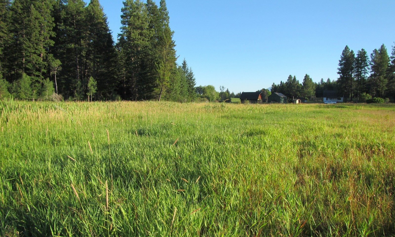
Figure 1. This ecological site lies on depressional areas on valley floors, in close proximity to conifer dominated mountain slopes.
Table 2. Representative physiographic features
Landforms (1) Valley > Depression
Elevation 2296 – 4101 ft Slope 0 – 5 % Water table depth 12 – 24 in Aspect W, NW, N, NE, E, SE, S, SW Climatic features
AQUIC/FRIGID
Mean Annual Precipitation = 20 inches
Mean Annual Air Temperature = 33-56 degrees Fahrenheit
Frost / Freeze Free Days = 90-120 daysTable 3 Representative climatic features
Frost-free period (characteristic range) 60-90 days Freeze-free period (characteristic range) 110-130 days Precipitation total (characteristic range) 20-20 in Frost-free period (actual range) 20-90 days Freeze-free period (actual range) 90-130 days Precipitation total (actual range) 20-20 in Frost-free period (average) 70 days Freeze-free period (average) 120 days Precipitation total (average) 20 in Characteristic rangeActual rangeBarLineFigure 2. Monthly precipitation range
Characteristic rangeActual rangeBarLineFigure 3. Monthly minimum temperature range
Characteristic rangeActual rangeBarLineFigure 4. Monthly maximum temperature range
BarLineFigure 5. Monthly average minimum and maximum temperature
Figure 6. Annual precipitation pattern
Figure 7 Annual average temperature pattern
Climate stations used
-
(1) EUREKA RS [USC00242827], Eureka, MT
-
(2) FORTINE 1 N [USC00243139], Eureka, MT
-
(3) OLNEY [USC00246218], Whitefish, MT
-
(4) WHITEFISH [USC00248902], Whitefish, MT
-
(5) KALISPELL 9 NNE [USC00244560], Kalispell, MT
-
(6) CRESTON [USC00242104], Kalispell, MT
">Influencing water features
Wetland Description Cowardin System: System: palustrine; Class-emergent wetland; Subclass=persistent; Water Regime (nontidal)= intermittently flooded <br />
HGM (Hydrogeomorphic) Wet MeadowSoil features
Soils typical of the Wet Meadow ecological site are poorly or very poorly drained, very deep and have a water table at or near the surface for much year, except during summer months when evapotranspiration demands are greatest and water tables are drawn down. Soils commonly have a thin mantle of decomposing organic material (defined for this site as being less than 8 inches or 20 cm in thickness). Soil parent materials are fine-silty mineral material that is common to overbank deposition adjacent to riparian areas and this finer material may overlie more gravelly recent alluvium at depth. Most soils in wet meadow areas are classified within the Mollisols soil order, having a dark organic-rich surface mantle or epipedon. More specifically, these soils are in the Aquolls suborder indicating they remain saturated within 50 cm of the soil surface year round. These soils often occur in marginal areas of larger fens or in very small fens that either have not accumulated the greater thickness of organic material or have some limited amount of flow through drainage which keeps them in a state of hydrologic equilibrium. Other soils that occur in the wet meadow areas are Typic Endoaquents, which lack the thickness of dark organic-rich soil surface layer to be classified as Mollisols. These soils, classified as Entisols, may occur closer to the drainage channel areas where more frequent flooding scours or deposits more coarse material. There may be adjacent areas within more true closed depressions that will accumulate the necessary thickness of organic material needed to be classified as a Histic subgroup or true Histosols. Vegetation on wet meadow areas must tolerate saturation and rare sheet flow flooding and spring melt water inundation. Soils on these sites are described as being hydric soils and have redoximorphic features from changes in soil saturation, which causes oxidation and/or reduction of iron primarily, but also manganese in the soil. The reduced ion of iron is highly mobile within the soil and some soil layers that undergo prolonged saturation will have a gleyed (blue gray or greenish gray) coloration due to the almost complete removal of iron from that layer. Soils in the Typic Endoaquents and Fluvaquentic Endoaquolls subgroups have diagnostic features including a mollic epipedon, endosaturation, a cambic horizon and reduced matrix.
For more information on soil taxonomy, please follow this link:
http://http://www.nrcs.usda.gov/wps/portal/nrcs/detail/soils/survey/class/?cid=nrcs142p2_053580
Figure 8. Soils associated with this Wet Meadow ecological site, note the seasonally high water table.

Figure 9. Soil horizons associated with this Wet Meadow ecological site, note the lighter gleyed soil material.
Table 4. Representative soil features
Parent material (1) Alluvium – metasedimentary rock
Surface texture (1) Silt loam
(2) Loam
Family particle size (1) Fine-silty
(2) Fine-loamy
Drainage class Poorly drained to very poorly drained Permeability class Moderate Soil depth 60 – 100 in Surface fragment cover <=3" Not specified Surface fragment cover >3" Not specified Available water capacity
(4-7.5in)Not specified Soil reaction (1:1 water)
(6-7in)Not specified Ecological dynamics
Overview
These wet meadow communities are dominated by wetland obligate species (meaning that they almost always occur (estimated probability greater than 99 percent) under natural conditions in wetlands), particularly Northwest Territory sedge. Other obligate wetland species include water sedge and Nebraska sedge. There are a wide variety of other species present that range from facultative wetland to upland designated species. Mountain rush is a facultative wetland designated species, while fowl bluegrass and field horsetail are facultative designated species. An upland species that occurs frequently is western showy aster.
These occur within larger valley areas. They are typically surrounded by forested areas, generally of the Douglas fir ecological sites. These meadows have been kept free of upland shrub and conifer species establishment through a water table within 12 inches of the surface which is generally intolerable to upland shrub species and conifers of the surrounding areas. There is seasonal drying during the hot summer months. Periodic fire can also reduce encroachment of shrub and conifer species into the wet meadow. Typically, the native plant species within the reference phase are all obligate wetland carex species that have high foliar cover, and are very productive. Shrub and tree species adapted to wet environments can occur including black cottonwood (Populus balsamifera), Sitka alder (Alnus viridis), silverberry (Elaeagnus commutata), Bebb willow (Salix bebbiana) and other blackberry, currant and willow species.
Disturbance Dynamics
Dynamics within State 1:
Disturbance dynamics within the natural functioning state include: fire, beaver dams, low precipitation or snowpack years and ungulate grazing. These disturbances are viewed as potentially changing the plant population composition to a minor extent from one phase to another within State 1 but with the ability to return to any phases with time after disturbance. These disturbances affect hydrology which is critically important to this site. Moderate disturbance will increase baltic rush (Juncus balticus) and associated forbs (Hansen, 1992), while severe disturbance may lower the water table and cause the site to be dominated by species such as Kentucky bluegrass (Poa pratensis), fowl bluegrass (Poa palustris), common silverweed (Potentilla anserina) or redtop (Agrostis stolonifera) (Hansen, 1992). Moderately disturbed sites will improve rapidly with protection due to the rhizomatous nature of Northwest Territory sedge (Carex utriculata). This site is flooded long enough to provide nesting habitat for waterfowl, but has limited use by songbirds and small mammals because of the lack of diversity and flooded soils. It is an important habitat for raptors, deer, and elk. Beaver dams assist in controlling the downcutting of channels, bank erosion, and the movement of sediment downstream (Gordon and others 1992). When beaver construct a dam, they raise the water table in the area, which provides water for hydrophytic plants. The beaver dam also slows down the water in the channel, which allows suspended sediment to be deposited behind the dam. The combination of sediment deposition and plant reproduction raises the channel bed (Hansen, 1992).
Fire can occur, though rarely and only in dry years within wet meadows. These fires would eliminate conifer and shrub encroachment on the site and maintain the reference phase community dominated by sedges. Typically, fires would only top burn the current year’s growth of the sedges. In particular, Carex utriculata is resistant to damage by fire through its extensive root system and resprouting capabilities, except where hot fires penetrate the peat soil. As well, Carex utriculata can be in the soil seed bank up to 18 inches deep, so it may establish from on-site seed after fire. Fire in wet meadows is highly dependent upon the surrounding vegetation type carrying the fire to these saturated sites. Within the Seeley-Swan Ranger District of the Flathead National Forest, the subalpine fir/queencup beadlily ecological site typically surrounds these wet meadows, which has low occurrence but high severity and has a fire free interval of approximately 130 years. Generally, these wet meadows are saturated that fires will move around these low lying areas and stay within the conifer community. Mixed severity fires account for 0 to 67 percent of the fires in the Northwest Riparian Communities (USDA, USFS, Fire Effects Information System, Fire Regimes). High severity fires that occur during severe drought years (Replacement), account for 33 to 100 percent of the fires occurring (USDA, USFS, Fire Effects Information System, Fire Regimes). The fire return interval is thought to be 35 to 200 years or more than 200 years. So, fires are rare within this site, but would serve to limit conifer and shrub encroachment. If a severe fire would occur within wet meadows and destroy the rhizomes of the sedges, then a threshold would be crossed and major species composition could occur. Fire in surrounding forested communities could also impact the hydrology of the wet meadows and cause increased runoff, and potentially groundwater flow, by decreasing live trees upslope and potentially change the species composition of the wet meadows (Steve Shelly, personal communication, 2015). As well, extensive epidemics of forest disease or pests that lead to large scale death of trees could attain the same result.
Beaver damming, within the areas that do have some water flow in channels, can lead to changes in plant species composition by flooding one area and concomitantly drying another. These are viewed as naturally functioning disturbances that would lead to ponding and inundation of an area and therefore drying of another area leading to potentially shrub invasion and if long enough, conifer invasion to a small scale. Presence of beaver damming would potentially lead to a mosaic effect on the plant communities potentially as opposed to the typical saturated wet meadows with sedge vegetation within a larger landscape of conifer dominated environment or a less saturated shrub type of wet meadows.
Low precipitation or drought years that impact precipitation and snow melt could potentially cause change in plant species composition by allowing shrubs in invade the site. Less precipitation and snow melt would decrease current year growth of the dominant sedge species at the reference phase, and allow drier site shrubs to potentially invade, but would not cause a state change since a resumption of normal precipitation would generally lead to resumed saturated conditions that preclude shrub encroachment. A severe drought that would adversely affect the sedge community and allow the establishment of dry site species would have crossed a threshold and cause a state change.
Ungulate grazing would be considered within the range of normal functioning disturbances that may change some species composition within State 1 if it were light grazing, seasonal or rotational, did not lead to extensive trailing, wallowing or cut banking of flow through channels. Ungulate hoof action can break up the rhizomatous sod, which can lead to unvegetated microsites conducive to shrub encroachment; in addition, pugging and hummocking can create some surface flow patterns which may accelerate water loss from the wet meadow. Urine and feces can change nutrient concentration as well. If the ungulate use is low, then it is viewed as normally functioning. Carex utriculata is considered moderately tolerant of grazing, though it may be replaced by other species when heavily grazed over extended periods. The saturated soils likely are susceptible to trampling and compaction though high water tables throughout the growing season tend to limit access by livestock and thereby reduce impacts. If the ungulate use if high, concentrated or during sensitive periods of plant growth, the impact can be severe and cause a state change by affecting soil compaction, water loss through trailing, pugging, hummocking changing surface flow patterns, severe changes in nutrient concentration through very high levels of urine and feces as well. These disturbances also could be exacerbated by drought or other disturbances higher upslope in the watershed that affect groundwater discharge and surface sheet flow.
Large scale timber harvesting upslope or higher in the adjacent watershed to the wet meadows can cause a state change to occur. If there were a large, extensive clear-cut that caused abrupt changes in the hydrology upslope of the wet meadows and affect groundwater or surface flows these would cross a threshold and cause either a state change to dry site species, or an increase in run-in to the wet meadow since the removal of trees reduces the water uptake. In addition, loss of shading by adjacent conifers may likely be beneficial to the wet meadows as most of the species are shade-intolerant. Very small scale timber harvesting or that was not clear-cut prescription, would not cause a threshold to be crossed and a state change to occur. This dry site species community could be more at risk to weed species invasion including timothy (Phleum pratense), Canada thistle (Cirsium arvense) or reed canarygrass (Phalaris arundinacea). Overstocked surrounding forests can potentially alter the water balance of wet meadows by taking up more water in the trees than a non-overstocked forest.
Road building upslope or higher in the watershed from a wet meadows could cause a threshold to be crossed and a state change to occur if it impacted surface flow to a degree that most of the upslope water is diverted away from the lower wet meadows. Less surface flow would cause drying of the site leading to dry site species invading and possibly weedy species as well. Water well establishment in the vicinity or upslope of the wet meadows could cause less groundwater available to maintain saturated soils for the site and could cause a threshold to be crossed and a state change to dry site species to occur. As well, any ditching or draining of wet meadows would cause a threshold to be crossed in the normal functioning hydrology of the wet meadows and a state change to dry site species would occur. This site would be more vulnerable to weedy species invasion.
Dynamics that cause a State change:
Three major disturbances that can occur in this ecological site that could cross a threshold triggering a state change would include a significantly altered hydrologic regime and invasion by reed canary grass. If the hydrologic regime has been severely altered and causes a significant reduction in water flow into a wet meadows, then a state change can occur causing dry site or upland species to invade and succeed in the wet meadows. Once this threshold has been crossed significant human input is required to revert the site to its natural hydrologic regime and native vegetation. Dry site or upland species are not dependent on a hydrologic regime and would outcompete the native wetland obligate sedge species. Once upland species have outcompeted and dominated the vegetative community, associated upland weed species can also thrive given adequate propagules.
A weed species of critical importance to this ecological site is the escaped cultivar of reed canary grass. This cultivar is exceeding competitive against the native community with the addition of nutrients from agricultural run-off. Therefore, a review of scientific literature on reed canary grass and other upland weed species follows.
A wet meadows can be converted to a plowed field of either pasture or cropland grass species after the wet meadows has had its hydrologic regime severely altered through ditching and or draining.
Effects of land management practices on ecological dynamics and invasive species invasion theory
Invasion of weedy species into native vegetation communities requires an understanding of the processes and mechanisms by which an invasion occurs. Resistance and resilience of the native community are essential elements in predicting the success of the invasion. There are two counter point theories on invasive species. The driver theory considers the invasive species to be driving species decline while the passenger model sees the invading species as filling in empty niches left by habitat alteration (Didham, 2005). The passenger model suggests that disturbance is the cause and if stopped, invasion can be reversed. Potential mechanisms of invasion include theories such as novel weapons, enemy release, competitive superiority, and manipulation of environment. Novel weapons include biological weapons or associations with micro-organisms that allow the invader species to either access new resources or steal them from indigenous plants (Tannas, 2011). Specifically, arbuscular mycorrhizal fungi may provide a substantial competitive advantage to spotted knapweed by carbon parasitism (Carey, 2004). In these cases, the invader uses these weapons to drive the invasion process. Enemy release describes the concept that once invader species are released from their native predator species or chemical warfare within their original community, they are more aggressive in their new community (Blumenthal 2006, Callaway and Aschelhoug 2000). The invader species may have characteristics that allow it to be more competitive than resident plant species such as grazing resistance, adaption to a harsh environment or another competitive ability (Tannas, 2011). Invading species can manipulate the environment to their advantage through resource competition. Mechanisms include modifying light interception, water uptake efficiency or change in soil water holding capacity, nutrient uptake and cycling (D’Antonio and Vitousek, 1992). The final outcome of invasion is establishment of the invading species which occurs as either dominance, coexistence, or exclusion from the indigenous plant community (Seabloom, 2003). D’Antonio and Vitousek (1992) stated grass invasions are particularly important because they are actively moved by humans and exotic grasses compete effectively with native species in many ecosystems. In addition, dominant grasses may change nutrient cycling, modify regional microclimates and alter fire dynamics.
Wetland Designations
Weedy species can be divided into categories based on affinity to wetlands through the Wetland Indicator Status by the 1988 US Fish and Wildlife Service’s national list of plant species that occur in wetlands.
Species categorized as obligate (OBL) are hydrophytes that almost always occur in wetlands. The sedges within the reference community of this ecological site are within this designation.
Species categorized as facultative wetland (FACW) are hydrophytes that usually occur in wetlands, but may occur in non-wetlands. Reed canarygrass is in this designation and may occur in this ecological site.
Species categorized as facultative (FAC) are hydrophytes that occur in wetlands and non-wetlands. Weedy species found in this ecological site that are FAC include: quackgrass, redtop, timothy, creeping meadow foxtail, Kentucky bluegrass and Canada thistle. Canada thistle is on the Montana state noxious weeds list.
Species categorized as facultative upland (FACU) are non-hydryophytes that usually occur in non-wetlands, but may occur in wetlands. Weedy species found in this ecological site that are FACU include: orchardgrass and dandelion.
Weed species designated facultative wetland:
The following weedy cultivar species is found within State 1 in lower amounts and as a dominant species in State 3.
Wetlands have a higher percentage of weed invasions compared to other vegetation communities. As a whole, wetlands serve as sinks for nutrients, water and sediments (Zedler, 2004). These abiotic attributes as well as changes from disturbance that affect hydrology, vegetation canopy gaps, soil structure exacerbate invasions, particularly of aggressive, weedy invaders that form monospecific stands. A particularly aggressive wetland invasive plant is Phalaris arundinacea (Phalaris). Phalaris is native to North America and can grow in a non-invasive way. Numerous introductions of the European population of Phalaris has potentially caused these two to hybridize and become invasive (Lavergne and Molofsky, 2004). The invasive form is likely an admixture of these populations. Phalaris is a C3 type, cool season, 1 to 2 meter tall, long-lived perennial that produces dense crowns and a prominent network of rhizomes (Hitchcock, 1950; Lavergne and Molofsky, 2007). Phalaris can establish early and quickly in wetlands due to its early season growth, clonal growth form, morphological plasticity, high architectural plasticity, ability to quickly assimilate nutrients and increase aboveground growth substantially, adapt to various flooding regimes and even drought (Gebauer et al 2015; Lavergne and Molofsky, 2004; Herr-Turoff and Zeller, 2007; Green and Galatowitsch, 2001; Kercher and Zedler, 2004). Phalaris can establish through its substantially numerous outcrossed seeds, in a yearly seed crop. It can also reproduce vegetatively by propagation of vigorous rhizomes and tillers. It can establish in the early growing season and thereby attaining larger size and height in comparison to other plant species and be able to outcompete for light, thereby shading competitors (Herr-Turoff, 2007). This is also enhanced by its rapid stem elongation. Kercher (2007) concluded that Phalaris invasion can be summarized as a three step process. Initially, resident native species decrease with prolonged flooding and sediment additions. These factors along with increased nutrients, accelerated Phalaris aboveground growth and led to a monospecific stand. Finally, native species further declined with an increase in Phalaris. Disturbances exacerbate this process. Resident native plant communities in areas with minimal disturbance can remain dense and vigorous. Therefore, when anthropogenic disturbances coincide with an increase in gross supply of resources, the more tolerant and fast growing and morphologically plastic plants like Phalaris can invade rapidly. Once established, Phalaris can grow as a sward in lower water conditions (intermittent and early season flooding), or as a tussock in higher water conditions (constant flooding) (Herr-Turoff, 2007). Early season flooding increased the lateral spread of individual shoots of Phalaris causing a sward. In the tussock growth form, Phalaris tolerated longer durations of flooding and more than doubled its aboveground biomass. Phalaris has the highest level of root airspace when compared with numerous other wetland plant species (Kercher and Zedler, 2004). Thereby, it can tolerate numerous flooding regimes. It can change the ratio of shoot to root growth, depending on environmental conditions. In high nutrient conditions, Phalaris is able to absorb and use nutrients quickly to accelerate shoot versus root growth. The greater plasticity in root / shoot allocation with changes in nitrate-Nitrogen additions and proportional allocation to root biomass that was greater than the native community are factors that account for the dominance of Phalaris (Green 2001). It can also increase tiller length and angle of branching to daughter tillers (Martina, 2013). Phalaris produced significantly more tillers that were more widely dispersed in saturated conditions. Increased soil nitrogen did not affect the spatial pattern of tillers, but did affect biomass production, shoot to root ratio and the biomass per tiller. This allows it to spread quickly throughout an area. Phalaris also has a plastic response to carbon gain to nitrogen supply (Holaday 2015). When nitrogen is high, Phalaris strongly increases CO2 assimilation, photosynthetic nitrogen use efficiency and respiration. When it is deprived of nitrogen, Phalaris has a decrease in leaf nitrogen but not vacuolar membrane nitrate (while both decreased for native species). Phalaris doubled CO2 assimilation in 12 days after being supplied nitrogen after being deprived. This plasticity was not absorbed to this degree in other wetland native plants. Therefore, Phalaris can quickly respond to changes in carbon and nitrogen. Additions of nutrients into natural wetlands can be a problem in urban and agricultural areas. Phalaris produces a dense, high carbon to nitrogen litter layer that impedes the germination and growth of competitor plant species (Molofsky et al 2014). Along streams, Phalaris can increase sediment deposition and reduce water circulation through dense stands that grow into the stream channel (Werner and Zedler, 2002). Phalaris can also tolerate drought conditions. In dry soil, it has significantly higher growth and fecundity versus in saturated soil conditions.
Numerous control strategies have been developed for Phalaris. The successful strategies include adapting restoration to a landscape scale size and using physical and chemical control coupled with hydrological management and subsequent restoration on native community structure and composition (Lavergne and Molofsky, 2007).
Weed species categorized as facultative species:
The following weed species can occur in the natural hydrologically intact State 1 community of wetland obligate sedge community or in the severely altered hydrology community in State 2. These weeds are able to thrive in both wetland and non-wetland environments.
Quackgrass (Elymus repens) is an undesirable weed species. It is a cool season, exotic, perennial, rhizomatous graminoid. It propagates mainly by rhizomes, but also from seed. It is adapted to certain seasonal fires because of its rhizomes. It is best eradicated by a combination of mowing, burning and chemical applications.
Redtop (Agrostis gigantea) and creeping bentgrass (Agrostis stolonifera) are both invasive weedy species. They often hybridize and therefore are treated the same here. It is native to Europe and was introduced as a pasture grass. It is perennial, rhizomatous, coo season, sod forming grass with either erect or decumbent stems. It regenerates vegetatively and by seed and spreads rapidly with strong rhizomes. It tolerates some flooding but is not tolerant of drought. It is fairly resilient to fire because of its rhizomes and buried seed. Fire does top kill redtop.
Timothy (Phleum pratense) is an introduced (from Eurasia), cool season, perennial bunchgrass that grows to 20 to 40 inches tall. It can grow on a variety of habitats but is best suited to well drained moist clay or loam soils. It was cultivated for hay and pasture use. It is palatable and nutritious forage for cattle and big game. It is generally short-lived (4 to 5 years) but can live up to 6 to 7 years. It has a moderately shallow and fibrous root system which can extend to 48 inches into the ground. Timothy is non-rhizomatous and forms vesicular-arbuscular endomycorrhizal associations. It reproduces mainly from seed and vegetatively by tillering. It is a prolific seed producer. Timothy and Kentucky bluegrass are of great concern since they establish quickly, spread vigorously and usually escape early detection. Control should include elimination and simultaneous introduction of desirable competitor native species. Timothy is well adapted to fire since fire stimulates production of reproductive tillers. Although it can be harmed if burned when actively growing in the spring and summer. It is fairly tolerant to fire when dormant.
The weedy species creeping meadow foxtail, Alopecurus arundinacea has numerous cultivars. The cultivar “Garrison” was released by the NRCS in 1964. It is from Eurasia and is an aggressive invader of wetland areas. It came to NA from settlers from eastern Germany and western Russia. It is a perennial grass, 3 to 6 feet tall, fairly vigorous rhizome, with a very large root system. It can grow 4 feet of crown diameter growth per year. Therefore, it is grazing tolerant. As well it is tolerant of a wide range of pHs and high levels of nitrogen and moderate salt levels, very flood tolerant and fairly drought tolerant. It is adapted to cold temperatures and is extremely winter hardy. It has early spring growth and grows quickly and can outcompete native vegetation. It proliferates by wind and water born seed. It can grow in many soil types even sand, clay, peat, and muck.
Kentucky bluegrass (Poa pratensis) is an introduced, perennial, and short to medium tall, cool-season, sod forming grass. It is shallow rooted and is intolerant to drought. It is found in moist sites in areas with cool and humid climates or riparian areas. Kentucky bluegrass is a vigorous herbaceous competitor with rhizome expansion, abundant seed, good seedling recruitment and quick establishment on disturbed sites. It is well adapted to meadows which have seasonally high water tables and mid-summer drought. It is naturalized and can dominate meadows, particularly ones that were once dominated by tufted hairgrass (Deschampsia ceaspitosa) and sedges. It is highly palatable to cattle. The rhizomes of Kentucky bluegrass help it survive quick moving fires, though postfire vigor and density are greatly affected. The most damaging fires occur in late spring after Kentucky bluegrass has been growing at least a month. Cool fires conducted when plants are dormant have little effect.
Canada thistle (Cirsium arvense) is a perennial, introduced (from SE Europe) forb with creeping horizontal lateral roots with dense clonal growth and a dioecious habit. Canada thistle has deep and wide spreading root system with a slender taproot and far-creeping lateral roots. It reproduces sexually by seed (this is the long distance dispersal strategy) and vegetatively by creeping roots (local spread strategy). It is adapted to survive fire on site with its root system and colonize recently burned sites with bare soil by seed. It has invaded nearly every type of upland herbaceous vegetation community, particularly prairie and riparian areas. Montana State listed Noxious Weeds List.
Weed species designated facultative upland species:
This weed species is found primarily in upland environments found in State 2.
Orchardgrass (Dactylis glomerata) is an undesirable weed species. It was introduced to eastern US from Europe in 1760. It is a cool season, perennial bunchgrass, which is nonrhizomatous but does produce a dense sod of medium sized roots. It reproduces largely by seed and tiller formation. It is reported to increase or remain stable after fire. It does not withstand continuous heavy forage use by cattle.State and transition model
More interactive model formats are also available. View Interactive Models
Click on state and transition labels to scroll to the respective textEcosystem states
T1A - Hydrology of ecological site severely altered via extended drought, ditching/draining, improper grazing management. T1B - Reed Canary Grass propagules introduced and dominates any community within State 1. T1C - Wet meadows dewatered, plowed and planted with pasture or cropland grass species. R2A - Hydrological function restored to reference conditions; weed management practices. R3A - Extreme weed management practices. R4A - Hydrologic function restored to reference conditions; seeding with native obligate wetland sedges State 1 submodel, plant communities
1.1A - Hydrology altered via drought, improper grazing management, ditching/draining decreasing sedge community and allowing Bluejoint reedgrass, shrub and conifer species to increase from periphery of wet meadows to interior of wet meadows. 1.1B - Introduction of weed propagules and weed canopy cover >10% in the reference community. 1.2A - Hydrology restored to allow sedge community to dominate and reduce Bluejoint reedgrass, shrub and conifer species to periphery. 1.2B - Introduction of weed propagules and weed canopy cover greater than 10 percent in the modified hydrology community. 1.3A - Weed management to reduce weed species to below 10 percent canopy cover. 1.3B - Weed management to reduce weed species to below 10 percent canopy cover. State 2 submodel, plant communities
2.1A - Introduction of weed propagules into the severely altered hydrology community. Community Phase Pathway 2.1A 2.2A - Weed management practices, Proper Grazing Management. Community Phase Pathway 2.2A State 3 submodel, plant communities
State 4 submodel, plant communities
State 1
ReferenceThis is the historic reference state with normal functioning hydrology and wetland obligate sedge species dominating the vegetation community.
Community 1.1
Reference - Sedge Community, Intact HydrologyDominated by wetland obligate sedge species such as Northwest Territory sedge, water sedge and Nebraska sedge
Forbs minor component; minimal weeds present
This community phase has intact natural hydrologic function, that has allowed wetland obligate sedges, particularly Northwest Territory sedge, Nebraska sedge, and water sedge to dominate while bluejoint reedgrass, shrubs, and conifer species are restricted to the periphery.Dominant plant species
-
Northwest Territory sedge (Carex utriculata), grass
-
water sedge (Carex aquatilis), grass
-
Nebraska sedge (Carex nebrascensis), grass
Community 1.2
Modified Hydrology Community PhaseBluejoint reedgrass co-dominated, shrubs present, trees and shrubs encroaching on outer, drier edge of wet meadow. These encroaching species are: Black Cottonwood, Silverberry, Sitka alder, Bebb willow, currant, thimbleberry, conifer species. Once hydrological function is restored to normal, the encroaching species cannot thrive in the wetter environment and dominance is resumed by sedges.
This community phase has slightly modified hyrologic function from the reference community of 1.1, that has allowed bluejoint reedgrass, shrub and conifer species to encroach upon the native wetland obligate sedge community of the wet meadows. Species that encroach include black cottonwood, Sitka alder, silverberry, Bebb’s willow and other willow, blackberry and currant species.Dominant plant species
-
bluejoint (Calamagrostis canadensis), grass
-
Northwest Territory sedge (Carex utriculata), grass
-
water sedge (Carex aquatilis), grass
-
Nebraska sedge (Carex nebrascensis), grass
Community 1.3
Weed species present CommunityWeedy species less than 10 percent canopy cover
reedcanarygrass, redtop, quackgrass, silverweed cinquefoil
This community has had an increase in weedy species such as reed canarygrass, redtop, quackgrass or silverweed cinquefoil less than10 percent of canopy cover.Dominant plant species
-
silverweed cinquefoil (Argentina anserina), shrub
-
Northwest Territory sedge (Carex utriculata), grass
-
Nebraska sedge (Carex nebrascensis), grass
-
water sedge (Carex aquatilis), grass
-
reed canarygrass (Phalaris arundinacea), grass
-
redtop (Agrostis gigantea), grass
-
quackgrass (Elymus repens), grass
Pathway 1.1A
Community 1.1 to 1.21.1A Hydrology altered via drought, improper grazing management, ditching/draining decreasing sedge community and allowing Bluejoint reedgrass, shrub and conifer species to increase from periphery of wet meadows to interior of wet meadows. This pathway denotes a modified hydrology regime with an increase in bluejoint reedgrass, the shrub species <a class="species-link" href="https://plants.usda.gov/core/profile?symbol=BENA" target="_blank" title="Open in plants.usda.gov"><i>Betula nana</i></a>, Salix or alder species and/or conifer species, possibly due to ditching, draining, drought or improper grazing management. Improper grazing management would affect hydrologic regime through ungulate hoof action that could cause breakage of the organic peat layer of the soil and dewatering of the site. As water leaves the site and the site becomes drier, bluejoint reedgrass, shrub and conifer species could invade from the periphery to the interior of the wet meadows.
Pathway 1.1B
Community 1.1 to 1.31.1B Introduction of weed propagules and weed canopy cover greater than 10 percent in the reference community. This pathway denotes an invasion of weedy species into the reference community that exceeds 10 percent canopy cover including species such as reed canarygrass, redtop, quackgrass, and silverweed cinquefoil.
Pathway 1.2A
Community 1.2 to 1.11.2A Hydrology restored to allow sedge community to dominate and reduce Bluejoint reedgrass, shrub and conifer species to periphery. This pathway is a resumption of the hydrology of the reference phase of a saturated site with some seasonal ponding and sheet flow. Wetland obligate sedge species dominate the site and bluejoint reedgrass, shrub and conifer species are limited to the periphery of the wet meadows.
Pathway 1.2B
Community 1.2 to 1.31.2B Introduction of weed propagules and weed canopy cover greater than 10 percent in the modified hydrology community. This pathway occurs when the bluejoint reedgrass community of 1.2 is invaded by weedy species beyond 10 percent canopy cover.
Pathway 1.3A
Community 1.3 to 1.11.3A Weed management to reduce weed species to below 10 percent canopy cover. This pathway occurs when weed management practices have lowered the weed canopy cover below 10 percent in the bluejoint reedgrass community.
Pathway 1.3B
Community 1.3 to 1.21.3B Weed management to reduce weed species to below 10 percent canopy cover. This pathway occurs when weed management practices have lowered the weed canopy cover below 10 percent in the reference plant community.
State 2
Severely Altered HydrologyThis state has severely altered hydrologic function from the reference state and native upland vegetation has significantly encroached into the native wetland obligate sedge vegetation community.
Community 2.1
Native Upland CommunityDominated by upland species including grass, forb, shrub species
weedy species less than 10 percent canopy cover.
Community Phase 2.1: Invasion and establishment of dry site species that are not wetland obligates including species found in this ecological site. Wetland obligate species may still be present but have lower cover than the dry site species. Dry site species that may be present include: Bromus marginatus, Calamagrostis Canadensis (FACW), Eurybia conspicua, Heracleum maximum (FAC), and Sanicula marilandica (FAC). FACW indicates a facultative wetland species designation or hydrophyte, meaning that it usually occurs in wetlands, but may occur in non-wetlands. FAC indicates a facultative species or hydrophyte, meaning that it occurs in wetlands and non-wetlands.Dominant plant species
-
bluejoint (Calamagrostis canadensis), grass
-
western showy aster (Eurybia conspicua), other herbaceous
-
common cowparsnip (Heracleum maximum), other herbaceous
-
Maryland sanicle (Sanicula marilandica), other herbaceous
Community 2.2
Invaded CommunityDominated by dry site weedy invasive species
within the dry site community: Kentucky bluegrass, Canada thistle, Quackgrass, redtop, timothy, creeping meadow foxtail, orchardgrass, curly dock, common mullein.
Community Phase 2.2: This phase has the dry site species of phase 2.1, but also includes non-native and noxious weed species that may include: Canada thistle, quckagrass, Kentucky bluegrass, redtop, silverweed cinquefoil and creeping meadow foxtail.Dominant plant species
-
Kentucky bluegrass (Poa pratensis), grass
-
redtop (Agrostis gigantea), grass
-
timothy (Phleum pratense), grass
-
creeping meadow foxtail (Alopecurus arundinaceus), grass
-
orchardgrass (Dactylis glomerata), grass
-
Canada thistle (Cirsium arvense), other herbaceous
-
curly dock (Rumex crispus), other herbaceous
-
common mullein (Verbascum thapsus), other herbaceous
-
silver cinquefoil (Potentilla argentea), other herbaceous
Pathway 2.1A
Community 2.1 to 2.22.1A Introduction of weed propagules into the severely altered hydrology community. Community Phase Pathway 2.1A This pathway occurs when the severely altered hydrology community is invaded by weedy species beyond 10 percent canopy cover.
Pathway 2.2A
Community 2.2 to 2.12.2A Weed management practices, Proper Grazing Management. Community Phase Pathway 2.2A This pathway occurs when weed management practices have lowered the weed canopy cover below 10 percent in the severely altered hydrology community.
State 3
InvadedThis is species composition change from State 1.0 into one dominated by the escaped cultivar of reed canary grass with a concomitant decrease in the native perennial obligate wetland sedges of the reference community.
Community 3.1
Reed canarygrass dominated community
Figure 10. A Wet Meadow ecological site that is dominated by reed canary grass and weedy species and very little cover of native sedges or grasses. This site is located nearby a wetter, organic soil fen area that has a tiny remnant of native sedges present.

Figure 11. Another photo of the same Wet Meadow ecological site with some wolfberry and taller shrubs along with reed canary grass, smooth brome and trace Canada thistle.
Reed canarygrass (PHAR3) dominates over sedges.
Community Phase 3.1: Reed canary grass propagules have been introduced into the native vegetation community and with the addition of high nutrient levels from agricultural run-off, has outcompeted and dominated the native wetland obligate sedge community.State 4
CultivatedThis is a plowed field of tame pasture and/or cropland grass species in which the natural hydrologic function has been severely altered to maintain the pasture or cropland.
Community 4.1
Cropland speciesAlfalfa, smooth brome.
Community Phase 4.1: Pasture or cropland species such as alfalfa and smooth brome nearly exclusively.Transition T1A
State 1 to 2T1A Hydrology of ecological site severely altered via extended drought, ditching/draining, improper grazing management. TRANSITION 1A: Abrupt, large scale, extensive or intensive disturbances to the hydrology of groundwater, surface water flow or precipitation including large scale harvesting or clearcutting, road building, water wells, concentrated ungulate use, ditching, draining, peat mining or severe stand replacing fire upslope from site or severe fire within site. These disturbances could cause a threshold to be crossed in which wetland obligate species no longer dominate the vegetation community. Rather, the community is comprised of upland plant species.
Transition T1B
State 1 to 3T1B Reed Canary Grass propagules introduced and dominates any community within State 1. TRANSITION 1B: Invasion by reed canary grass into any of the communities of State 1. Reed canary grass establishes via propagules of the cultivar and dominates the site by outcompeting native perennial obligate wetland sedges through various means including efficient use of additional nutrients supplied by agricultural run-off.
Transition T1C
State 1 to 4T1C Wet meadows dewatered, plowed and planted with pasture or cropland grass species. TRANSITION 1C: Abrupt, large scale, extensive or intensive disturbances to the hydrology of groundwater, surface water flow or precipitation from ditching and/or draining to create conditions for pasture and/or croplands. These disturbances could cause a threshold to be crossed in which wetland obligate species no longer dominate the vegetation community. Rather, the community is comprised of tame pasture and/or cropland grass species.
Restoration pathway R2A
State 2 to 1R2A Hydrological function restored to reference conditions; weed management practices. RESTORATION 2A: Hydrologic function restored to reference conditions; weed management practices to reduce upland weed species below the 10 percent canopy cover proportion.
Restoration pathway R3A
State 3 to 1R3A Extreme weed management practices. RESTORATION 3A: Extreme weed management practices that reduce the canopy cover of reed canary grass to less than 10% canopy cover; hydrologic function restored to State 1 if any changes due to reed canary grass have occurred.
Restoration pathway R4A
State 4 to 1R4A Hydrologic function restored to reference conditions; seeding with native obligate wetland sedges
Additional community tables
Table 5. Community 1.1 plant community composition
Group Common name Symbol Scientific name Annual production () Foliar cover (%) Table 6. Community 1.2 plant community composition
Group Common name Symbol Scientific name Annual production () Foliar cover (%) Table 7. Community 1.3 plant community composition
Group Common name Symbol Scientific name Annual production () Foliar cover (%) Table 8. Community 2.1 plant community composition
Group Common name Symbol Scientific name Annual production () Foliar cover (%) Table 9. Community 2.2 plant community composition
Group Common name Symbol Scientific name Annual production () Foliar cover (%) Table 10. Community 3.1 plant community composition
Group Common name Symbol Scientific name Annual production () Foliar cover (%) Table 11. Community 4.1 plant community composition
Group Common name Symbol Scientific name Annual production () Foliar cover (%) Interpretations
Supporting information
Other references
Allen, Douglas R.; Marlow, Clayton B. 1994. Shoot population dynamics of beaked sedge following cattle grazing. Journal of Range Management. 47(1): 64-69. [22923]
Hansen, Paul L. 1992. Classification and management of riparian-wetland shrub sites in Montana. In: Clary, Warren P.;
Chadde, S., J. Shelly, R. Bursik, R. Moseley, A. Evenden, M. Mantas, F. Rabe, B. Heidel. Wet meadows on National Forests of the Northern Rocky Mountains: Ecology and Conservation. U.S. Department of Agriculture, Forest Service, Rocky Mountain Research Station. GTR-RMRS-GTR-11. July 1998.
Hansen, Paul L. 1992. Classification and management of riparian-wetland shrub sites in Montana. In: Clary, Warren P.;
McArthur, E. Durant; Bedunah, Don; Wambolt, Carl L., compilers. Proceedings--symposium on ecology and management of riparian shrub communities; 1991 May 29-31; Sun Valley, ID. Gen. Tech. Rep. INT-289. Ogden, UT: U.S. Department of Agriculture, Forest Service, Intermountain Research Station: 68-78. [19098]
Soil Survey Staff. 2015. Illustrated guide to soil taxonomy. U.S. Department of Agriculture, Natural Resources Conservation Service, National Soil Survey Center, Lincoln, Nebraska.
Wakimoto, Ronald H.; Willard, E. Earl. 1991. Progress report: Monitoring post-fire vegetation recovery in ponderosa pine and sedge meadow communities in Glacier National Park, NW Montana. Research Joint Venture Agreement INT-89441. Ogden, UT: U.S. Department of Agriculture, Forest Service, Intermountain Research Station. 17 p. [17635]
Willard, E. Earl; Wakimoto, Ronald H.; Ryan, Kevin C. 1995. Vegetation recovery in sedge meadow communities within the Red Bench Fire, Glacier National Park. In: Cerulean, Susan I.; Engstrom, R. Todd, eds. Fire in wetlands: a management perspective: Proceedings, 19th Tall Timbers fire ecology conference; 1993 November 3-6; Tallahassee, FL. No. 19. Tallahassee, FL: Tall Timbers Research Station: 102-110. [25778].Contributors
Jay Skovlin
Stephanie Shoemaker
Beth Rowley
Pat O'ConnellApproval
Kirt Walstad, 3/11/2025
Rangeland health reference sheet
Interpreting Indicators of Rangeland Health is a qualitative assessment protocol used to determine ecosystem condition based on benchmark characteristics described in the Reference Sheet. A suite of 17 (or more) indicators are typically considered in an assessment. The ecological site(s) representative of an assessment location must be known prior to applying the protocol and must be verified based on soils and climate. Current plant community cannot be used to identify the ecological site.
Author(s)/participant(s) Contact for lead author Date 10/27/2023 Approved by Approval date Composition (Indicators 10 and 12) based on Annual Production Indicators
-
Number and extent of rills:
-
Presence of water flow patterns:
-
Number and height of erosional pedestals or terracettes:
-
Bare ground from Ecological Site Description or other studies (rock, litter, lichen, moss, plant canopy are not bare ground):
-
Number of gullies and erosion associated with gullies:
-
Extent of wind scoured, blowouts and/or depositional areas:
-
Amount of litter movement (describe size and distance expected to travel):
-
Soil surface (top few mm) resistance to erosion (stability values are averages - most sites will show a range of values):
-
Soil surface structure and SOM content (include type of structure and A-horizon color and thickness):
-
Effect of community phase composition (relative proportion of different functional groups) and spatial distribution on infiltration and runoff:
-
Presence and thickness of compaction layer (usually none; describe soil profile features which may be mistaken for compaction on this site):
-
Functional/Structural Groups (list in order of descending dominance by above-ground annual-production or live foliar cover using symbols: >>, >, = to indicate much greater than, greater than, and equal to):
Dominant:
Sub-dominant:
Other:
Additional:
-
Amount of plant mortality and decadence (include which functional groups are expected to show mortality or decadence):
-
Average percent litter cover (%) and depth ( in):
-
Expected annual annual-production (this is TOTAL above-ground annual-production, not just forage annual-production):
-
Potential invasive (including noxious) species (native and non-native). List species which BOTH characterize degraded states and have the potential to become a dominant or co-dominant species on the ecological site if their future establishment and growth is not actively controlled by management interventions. Species that become dominant for only one to several years (e.g., short-term response to drought or wildfire) are not invasive plants. Note that unlike other indicators, we are describing what is NOT expected in the reference state for the ecological site:
-
Perennial plant reproductive capability:
Print Options
Sections
Font
AAAAOther
PrintThe Ecosystem Dynamics Interpretive Tool is an information system framework developed by the USDA-ARS Jornada Experimental Range, USDA Natural Resources Conservation Service, and New Mexico State University.
Accessibility statement