
Natural Resources
Conservation Service
Ecological site EX043B15J952
Subalpine Windswept Shallow Meadow
25-30" PZ Cryic
Northern Rocky Mountain Front
Last updated: 4/07/2025
Accessed: 10/17/2026
-
Search


Major Land Resource Area or ecological site by name and/or ID.
PreviousSectionsNextGeneral information
Provisional. A provisional ecological site description has undergone quality control and quality assurance review. It contains a working state and transition model and enough information to identify the ecological site.
MLRA notes
Major Land Resource Area (MLRA): 043B–Central Rocky Mountains
This ecological site currently resides in the Major Land Resource Area (MLRA) 43B Central Rocky Mountains. The area of MLRA 43B is expansive and is further divided into Land Resource Units (LRU). This ecological site resides in LRU A – Northern Rocky Mountain Front. A detailed description of MLRA 43B can be found at: https://www.nrcs.usda.gov/wps/portal/nrcs/detail/soils/ref/?cid=nrcs142p2_053624
LRU notes
The landscape is mountains and the landforms include scarp slopes, dip slopes, mountain slopes, drainageways, bog, cirque, U-shaped valley and associated moraine and outwash features. Elevations range 1,000 to 3,175 meters (3,300 to 10,500 feet) (mean elevation is 1,900 m. or 6,200 ft.). The climate is cold and wet with mean annual precipitation of 1,050 mm (41 in.) and mean annual air temperature of 3 degrees Celsius (37 degrees F) with a soil temperature regime of cryic and soil moisture regime of udic or ustic. The geology of the area is dominated by Appenkunny and Grinnell argillite, Kootenai formation, Tertiary sedimentary rocks, Missoula group quartzite, glacial drift alluvium, Siyeh limestone and undifferentiated rock. The soils are dominantly moderately deep to very deep that formed from a variety of sedimentary rock parent materials on moderately steep to very steep mountain slopes. Soils fall into three soil orders: Inceptisols, Mollisols, and Alfisols. Most soils are loamy-skeletal and many, especially in the eastern part, contain significant amounts of calcium carbonate influencing both physical and chemical soil characteristics (horizons of calcium carbonate accumulation and corresponding alkaline pH values). Rock outcrop, rubble land, and surface rock fragments are common. There are few lakes but has numerous major drainages including Dearborn, Sun, Teton, Birch, Badger, Two Medicine, St. Maries, South and Middle Fork Flathead headwaters, Blackfoot headwaters. This is a snow dominated system. Wind is a major force shaping climatic patterns and vegetation structure. This area includes forested areas dominated by either Douglas fir, subalpine fir or white bark pine, and range areas dominated by rough fescue, Richardson’s needlegrass and bluebunch wheatgrass and assorted forbs.
This is related to the EPA land classification framework of: Level 3- 41 Canadian Rockies. Specifically, it includes Level 4-41a Northern Front.
This area is related predominantly to the USFS Provinces M333Cf Northern Rocky Mountain Front.Classification relationships
NPS Plant Community Name: Arctostaphylos uva-ursi /festuca campestris-Fesctuca idahoensis Dwarf-shrubland (CEGL005830).
Physiognomic Class Dwarf-shrubland (IV)
Physiognomic Subclass Evergreen dwarf-shrubland (IV.A.)
Physiognomic Group Needle-leaved or microphyllous evergreen dwarf-shrubland (IV.A.1.)
Physiognomic Subgroup Natural/Semi-natural needle-leaved or microphyllous evergreen dwarf-shrubland (IV.A.1.N.)
Formation Creeping or matted needle-leaved or microphyllous evergreen dwarf-shrubland (IV.A.1.N.b.)
Alliance Arctostaphylos uva-ursi/Festuca campestris-Festuca idahoensis Dwarf-shrubland (A.1079)
Alliance (English name) Kinikinnick or Bearberry Dwarf-shrubland Alliance
Association Arctostaphylos uva-ursi/Festuca campestris-Festuca idahoensis Dwarf-shrubland
Assosciation (English name) Bearberry or Kinikinnick /Rough fescue-Idaho Fescue Dwarf-shrubland
Damm Braun-Blanquet-type classification= Solidagini multiradiatae-Arctostaphyletum uva-ursi Association and Zigadeno elegantis-Caricetum scirpoideae.Ecological site concept
Ecological Site Concept
This ecological site occurs in the subalpine at elevations ranging 1,700 to 2,300 meters (5,575 to 7,550 feet), on moderately sloping (15 to 35 percent) backslope positions on knobs, ridges and slopes on mountain slopes, mainly on southeasterly aspects. This ecological site is found in small patches rather than large, broad expanses. In their vegetation map, the NPS associated this site with dry environments, that were mostly convex high elevation wind-battered sites that were hypothesized to be swept snow free by prevailing westerlies and sites not directly exposed could be impacted by eddy currents that redistribute the snowpack (NatureServe, 2007). These areas would not have the wind protection that a thick snow layer affords, nor would they have the additional water in spring from snow melt. Other areas that can have this ecological site include dipping bed landforms, shelf areas and structural benches. Specifically, this ecological site is found in the Marias Pass area. This ecological site is defined as having high cover of kinnickinick (arctostaphylos uva-ursi) and rough fescue (festuca campestris). The other constant associated species include the montane species: yarrow, rosy pussytoes, bluebell bellflower, northern bedstraw, common juniper and rose. Infrequent but moderate cover when occurring species include: pinegrass, shrubby cinquefoil, sulphur-flower buchwheat. This is a moderate statured dwarf-shrub and grassland. The soils of this ecological site are well drained and shallow to bedrock. Soil parent materials are colluvium or till over metasedimentary bedrock residuum. Surface textures are typically very gravelly having 35 to 60 percent gravel. Subsurface textures also contain greater than 35 percent rock fragments, are loamy causing these soils fall into the loamy-skeletal particle-size family. A very thin layer (0 to 5 cm) or no organic material is typically present at the soil surface. There are no water table, ponding, flooding or redoximorphic features in these soils. Due to the shallow depth of the soil profile the water-holding capacity of these soils is very limited and the soils will dry down rapidly between precipitation events during extended dry periods. These soils classified in the soil order of Inceptisols, which in soil formation terms means that the soils are characterized as having weak development of diagnostic features. Specifically, these soils are of the taxonomic subgroup Lithic Haplocryepts. Diagnostic soil features include an ochric epipedon (light colored surface), a cambic horizon (weakly developed subsurface horizon), and a lithic bedrock contact.Associated sites
EX043B15I954 Montane Very Deep Meadow 20-24" PZ Cryic Northern Rocky Mountain Front
This 43B Montane Very Deep Meadow ecological site is found in the montane zone, with an elevation range of 1,400-2,000 meters (4,600-6,500 feet.), on backslope positions with moderate slopes of 4-15 percent and southwesterly aspects on marginal ground moraines and complex landslides on lateral moraines. Infrequently, this site is found on alluvial fans, hogbacks, knobs, ledges and knolls. These are large patch sized meadows. The 43B Montane Very Deep Meadow ecological site has soils that are predominantly very deep and well drained. Surface textures are typically gravelly loam and subsurface layers fall into the fine-loamy particle-size family. These soils are classified in the Mollisols soil order having a thick dark surface with significant enrichment of organic matter and high base saturation. The 43B Montane Very Deep Meadow ecological site has a reference community of Rough fescue (Festuca campestris), shrubby cinquefoil (Dasiphora fruticosa), Idaho fescue (Festuca idahoensis), yarrow (Achillea millefolia), northern bedstraw (Galium boreale) and Ross’s sedge (Carex rossii).
Similar sites
EX043B15I954 Montane Very Deep Meadow 20-24" PZ Cryic Northern Rocky Mountain Front
These sites are similar in that the reference communities share the same species, though in different abundance, in that native perennial bunchgrasses dominate in the very deep meadow and kinnikinnick and rough fescue can dominate in the windswept shallow meadow due to high winds and shallow soil depth.
Table 1. Dominant plant species
Tree Not specified
Shrub (1) Arctostaphylos uva-ursi
(2) Juniperus communisHerbaceous (1) Festuca campestris
(2) Eriogonum umbellatumLegacy ID
R043BX952MT
Physiographic features
This ecological site occurs in the subalpine at elevations ranging 1700 to 2300 meters, on moderately sloping (15 to 35 percent) backslope positions on knobs, ridges and slopes on mountain slopes, mainly on southeasterly aspects. This ecological site is found in small patches rather than large, broad expanses. In their vegetation map, the NPS associated this site with dry environments, that were mostly convex high elevation wind-battered sites that were hypothesized to be swept snow free by prevailing westerlies and sites not directly exposed could be impacted by eddy currents that redistribute the snowpack (NatureServe, 2007). These areas would not have the wind protection that a thick snow layer affords, nor would they have the additional water in spring from snow melt. Other areas that can have this ecological site include dipping bed landforms, shelf areas and structural benches. Specifically, this ecological site is found in the Marias Pass area.

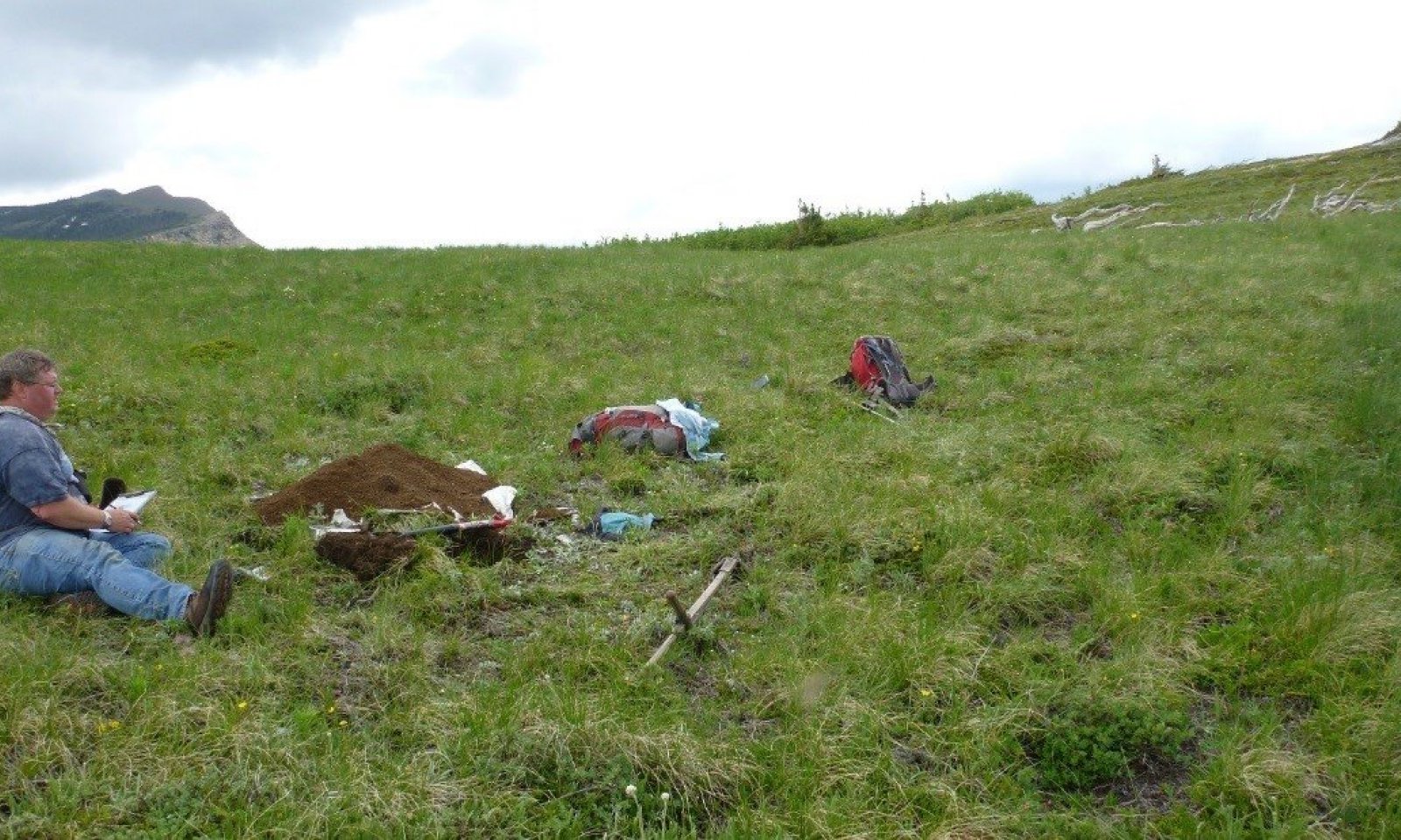
Figure 1. Landscape view of site, note knob landform, shallow soils (some bedrock outcrops) and dominance of kinnikinnick.

Figure 2. Windswept ridge location of this wind blasted ecological site.
Table 2. Representative physiographic features
Landforms (1) Mountains > Mountain slope
(2) Mountains > Knob
(3) Mountains > Ridge
Elevation 5577 – 7545 ft Slope 15 – 35 % Aspect SE Climatic features
CRYIC/UDIC soil temperature/moisture regimes
ST. MARY CLIMATE STATION:
Mean Annual Precipitation =45-75 inches
Mean Annual Air Temperature =30-39 degree Fahrenheit
Frost Free Days =30-50 daysTable 3 Representative climatic features
Frost-free period (characteristic range) 40 days Freeze-free period (characteristic range) 100 days Precipitation total (characteristic range) 20-30 in Frost-free period (actual range) 40 days Freeze-free period (actual range) 100 days Precipitation total (actual range) 20-30 in Frost-free period (average) 40 days Freeze-free period (average) 100 days Precipitation total (average) 30 in Characteristic rangeActual rangeBarLineFigure 3. Monthly precipitation range
Characteristic rangeActual rangeBarLineFigure 4. Monthly minimum temperature range
Characteristic rangeActual rangeBarLineFigure 5. Monthly maximum temperature range
BarLineFigure 6. Monthly average minimum and maximum temperature
Figure 7. Annual precipitation pattern
Figure 8 Annual average temperature pattern
Climate stations used
-
(1) ST. MARY 1 SSW [USW00004130], Babb, MT
-
(2) EAST GLACIER [USC00242629], East Glacier Park, MT
">Influencing water features
N/A
Wetland description
N/A
Soil features
This ecological site is found in the cryic soil temperature regime and the udic soil moisture regime. Cryic soils have average annual temperature less than 8 degrees Celsius, with less than 5 degrees Celsius difference from winter to summer. Udic soil moisture regime denotes that the rooting zone is usually moist throughout the winter and the majority of summer.
The soils of this ecological site are well-drained and shallow to bedrock. Soil parent materials are colluvium or till over metasedimentary bedrock residuum. Surface textures are typically very gravelly having 35 to 60 percent gravel. Subsurface textures also contain greater than 35 percent rock fragments, are loamy causing these soils to fall into the loamy-skeletal particle-size family. A very thin layer (0 to 5 cm) or no organic material is typically present at the soil surface. There are no water table, ponding, flooding or redoximorphic features in these soils. Due to the shallow depth of the soil profile the water-holding capacity of these soils is very limited and the soils will dry down rapidly between precipitation events during extended dry periods. These soils classified in the soil order of Inceptisols, which in soil formation terms means that the soils are characterized as having weak development of diagnostic features. Specifically, these soils are of the taxonomic subgroup Lithic Haplocryepts. Diagnostic soil features include an ochric epipedon (light colored surface), a cambic horizon (weakly developed subsurface horizon), and a lithic bedrock contact (Soil Survey Staff, 2015). For more information on soil taxonomy, please follow this link:
http://http://www.nrcs.usda.gov/wps/portal/nrcs/detail/soils/survey/class/?cid=nrcs142p2_053580
SOIL SERIES & TAXONOMIC CLASS NAME
Cowood Loamy-skeletal, mixed, superactive Lithic Haplocryepts
Figure 9. Close up of soils of this ecological site.
Table 4. Representative soil features
Parent material (1) Colluvium – metasedimentary rock
(2) Residuum – metasedimentary rock
Surface texture (1) Very gravelly loam
Family particle size (1) Loamy-skeletal
Drainage class Well drained Permeability class Moderate Soil depth 10 – 20 in Surface fragment cover <=3" Not specified Surface fragment cover >3" Not specified Available water capacity
(1.1-1.8in)Not specified Soil reaction (1:1 water)
(5.8-6.5in)Not specified Ecological dynamics
This ecological site is found in the montane and lower subalpine life zones in small patches rather than large, broad expanses. In their vegetation map, the NPS associated this site with dry environments, that were mostly convex high elevation wind-battered sites that were hypothesized to be swept snow free by prevailing westerlies and sites not directly exposed could be impacted by eddy currents that redistribute the snowpack (NatureServe, 2007). These areas would not have the wind protection that a thick snow layer affords, nor would they have the additional water in spring from snow melt. Other areas that can have this ecological site include dipping bed landforms, shelf areas and structural benches. Specifically, this ecological site is found in the Marias Pass area.
This ecological site is most similar to the 43B Montane Very Deep Meadow, which it is differentiated from by having a higher elevational range, 1,800 to 1,900 m (5,900 to 6,200 ft) compared to 1,400 to 1,700 m, (4,600 to 5,575 ft) and being small patches rather than large, broad expansive meadows. This site resides on a variety of smaller landforms knobs, talus cones whereas montane meadows resides mainly on moraines and hillslopes. The soils are different in that this site does not have argicryolls or typic haplocryalfs and montane very deep meadow ecological site does. The parent material also differs in that this site is mainly colluvium and till and montane very deep meadows has predominantly till, though some colluvium and alluvium. Montane very deep meadow ecological site is dominated by the tall grass rough fescue and Idaho fescue and consistently has a very low cover of the tall shrubs serviceberry and thimbleberry. Other shrub species can occur including: the low shrubs shrubby cinquefoil, wood’s rose, and kinnickinick. This ecological site is defined as being dominated by kinnickinick, and only has a trace presence of serviceberry and no thimbleberry. They share similar montane meadow forb herbaceous species such as: common yarrow (Achillea millefolium), rosy pussytoes (Antennaria rosea), northern bedstraw (Galium boreale), rose species, shrubby cinquefoil (Dasiphora fruticosa), and sulphur-flower buckwheat (Eriogonum umbellaturm).State and transition model
More interactive model formats are also available. View Interactive Models
Click on state and transition labels to scroll to the respective textEcosystem states
T1A - The introduction and establishment of weedy species, even at very low canopy cover values. T2A - Weed infestation from human, animal, or transportation corridors that allow non-native species to invade and establish within the grassland to the degree that native grass species decline. R3A - Proper grazing management that allows the cover and vigor of native bunchgrass, particularly rough fescue, to be restored. Other means such as chemical, mechanical, or biological may be needed to restore native bunchgrass species to dominance. State 1 submodel, plant communities
1.1A - A Significant time without fire, so that the historical fire return interval is lengthened and shrub and conifer species invade. 1.2A - A resumption of historic fire return intervals, so that woody shrub and conifer encroachments are suppressed, and grasslands are sustained. State 2 submodel, plant communities
2.1A - Heavy grazing or improper grazing management for sustained periods of time. 2.1B - significant time without fire 2.2A - A ceasing of heavy grazing or improper grazing management for sustained periods of time. 2.3A - A resumption of historic fire return intervals, so that woody shrub and conifer encroachments are suppressed, and grasslands are sustained. State 3 submodel, plant communities
3.1A - Significant time without fire, so that the historical fire return interval is lengthened and shrub species invade. 3.2A - Resumption of historic fire return intervals, so that woody shrub and conifer encroachments are suppressed, and grasslands are sustained. State 1
Historic Reference1.0 Historic Reference State with No Weedy Species Present
Characteristics and indicators. Kinnikinnick (<a class="species-link" href="https://plants.usda.gov/core/profile?symbol=ARUV" target="_blank" title="Open in plants.usda.gov"><i>Arctostaphylos uva-ursi</i></a>)(common juniper(<a class="species-link" href="https://plants.usda.gov/core/profile?symbol=JUCO6" target="_blank" title="Open in plants.usda.gov"><i>Juniperus communis</i></a>)-shrubby cinquefoil(dasiphora fruticosa)-rosa species)/rough fescue(<a class="species-link" href="https://plants.usda.gov/core/profile?symbol=FECA4" target="_blank" title="Open in plants.usda.gov"><i>Festuca campestris</i></a>)pinegrass(<a class="species-link" href="https://plants.usda.gov/core/profile?symbol=CARU" target="_blank" title="Open in plants.usda.gov"><i>Calamagrostis rubescens</i></a>)/yarrow(Achillea millefolia)-rosy pussytoes(antennaria rosea)-Ross’s sedge (<a class="species-link" href="https://plants.usda.gov/core/profile?symbol=CARO5" target="_blank" title="Open in plants.usda.gov"><i>Carex rossii</i></a>)-northern bedstraw(<a class="species-link" href="https://plants.usda.gov/core/profile?symbol=GABO2" target="_blank" title="Open in plants.usda.gov"><i>Galium boreale</i></a>)-sulpher-flower buckwheat(eriogonum umbellatum). The 43B Subalpine Windswept Shallow Meadow ecological site is dominated by the low-growing shrub kinnikinnick (<a class="species-link" href="https://plants.usda.gov/core/profile?symbol=ARUV" target="_blank" title="Open in plants.usda.gov"><i>Arctostaphylos uva-ursi</i></a>), and rough and Idaho fescues. Kinnikinnick is shade-intolerant and grows best in open areas, forming a compact and intricate mat (Severson, 1974). In the forest, it is found in more open canopies and has long, thin trailing stems. Kinnikinnick is a stoloniferous, mat-forming, woody subshrub. It has a compact clonal pattern. The main stems are prostrate with secondary branching stems ascending and erect to 15 cm. Regeneration primarily is asexual, with the second-year stolons producing adventitious feeding roots at the nodes. After seven or eight years, small nodules may appear at intervals along the buried stems. These are not nitrogen-fixing nodules. The berrylike drupes are dispersed by animals. Seedling growth is slow for the first 3 years, then increases. Roots can extend to a depth of 70 to 90 cm. Kinnikinnick browse is of moderate importance to bighorn sheep, mountain goat, black-tailed deer, white-tailed deer, and Rocky Mountain mule deer (Kufeld, 1973). Moose browse kinnikinnick on snow-free areas near trees on south and west aspects in early spring (Stevens, 1970). Black and grizzly bears eat the fruits in the autumn and especially in the early spring (Mace, 1986). Kinnikinnick is unpalatable to domestic livestock. It is easily killed by scraping or fire, but is able to regenerate from surviving parts or seed. It is a sprouting species that is best suited to short fire cycles with low fuel buildup and low fire intensities. Kinnikinnick is moderately resistant to trampling, with both low short- and long-term resilience (Zimmerman, 1984). It is a host to yellow witches’ broom, which affects spruce species (Watson, 1980). Rough fescue is a native, cool-season, perennial bunchgrass that produces thick mats of persistent sheath and stem bases: and culms grow to 107cm (3.5 feet) and leaf tufts to 40 cm (16 inches) in height (Cronquist, 1977). It has extensive fibrous roots to a depth of 122 cm (4 feet), 73 percent of which are concentrated in the top 15 cm (6 inches) of soil (Coupland, 1953). It regenerates from seed, tillers and sometimes rhizomes (Pavlick, 1984). It is well adapted to a short growing season by initiating growth following snowmelt and completes growth before the onset of summer drought. It is very productive and highly palatable to livestock and wildlife. It is used by bighorn sheep, mule deer, elk and bison. It is resistant to moderate grazing but heavy grazing can result in severely decreased root depth and biomass (Aiken, 1990). Grazing can cause a general decline in rough fescue coverage and is one of the first species to decline with common increasers with grazing being: Idaho fescue, needlegrass species, prairie Junegrass and Parry’s oatgrass. It is well adapted to periodic burning and resistant to light fire by their dense, tufted habit. It sprouts from surviving residual plants and colonizes from off-site wind-dispersed seed. Fire may top-kill plants, but cover and production is usually attained in 2-3 years post-fire. Severe damage can occur by hot, mid-summer wildfires (Wright, 1982). Rough fescue and elk sedge are considered very resistant to human trampling due to its tough core of the tuft, according to D. Cole of the USFS in his study of recreational human trampling effects on habitat types in western Montana. The majority of the loss of cover, a reduction of 50 percent, occurred in the first 400 passes. Thereafter, cover loss was stabilized from 400 to 800 passes. The community of rough fescue-timber oatgrass is considered very resistant to both light and heavy trampling (Cole, 1987). Asebrook (2010) found that in 31 plots sampled of this type of dwarf-shrubland (kinnikinnick-rough fescue) was in very good to excellent condition with very low cover of exotic species. Exotic grass cover averages one to three percent and exotic forb cover of one percent. There was little tree invasion no more than one percent cover within the plots, but half did have tree invasion at least at the edges. Rhizomatous shrubs have invaded 23 percent of the plots observed. Lack of fire was attributed to allowing woody plants to become established at the edges. Current trespass and grazing by livestock was noted as having an impact on this site although it is periodic with low overall impact.
Community 1.1
Reference Community PhasePlant Community 1.1 kinnikinnick(common juniper-shrubby cinquefoil-rose)/rough fescue(pinegrass)/yarrow-rosy pussytoes-bluebell bellflower-northern bedstraw-Sulphur-flower buckwheat
This ecological site is defined as having high cover of kinnickinick (arctostaphylos uva-ursi) and rough fescue (festuca campestris). The other constant associated species include the montane species: yarrow, rosy pussytoes , bluebell bellflower, northern bedstraw, common juniper and rose. Infrequent but moderate cover when occurring species include: pinegrass, shrubby cinquefoil, sulphur-flower buchwheat. This is a moderate-statured dwarf-shrub and grassland.Community 1.2
Shrub EncroachmentPlant Community 1.2 Shrub Encroachment
1.2 kinnikinnick-common juniper-shrubby cinquefoil-rose/(rough fescue(pinegrass)/yarrow-rosy pussytoes-bluebell bellflower-northern bedstraw-Sulphur-flower buckwheat)
This community has sustained shrub or tree encroachment due to a lack of fire. Likely shrub species to encroach on this community include serviceberry, kinnikinnick, shrubby cinquefoil, common juniper, Wood’s rose, snowberry, western snowberry, and dwarf bilberry. The tree species that encroach primarily are lodgepole pine, subalpine fir and Engelmann spruce.Pathway 1.1A
Community 1.1 to 1.2This pathway represents a significant time without fire, so that the historical fire return interval is lengthened and shrub and conifer species invade.
Pathway 1.2A
Community 1.2 to 1.1This pathway represents a resumption of historic fire return intervals, so that woody shrub and conifer encroachments are suppressed, and grasslands are sustained
State 2
Current Potential2.0 Current Potential State With Very Low Cover of Weedy Species
Characteristics and indicators. Current Reference State with weedy species present at a very low canopy cover value. kinnikinnick(<a class="species-link" href="https://plants.usda.gov/core/profile?symbol=ARUV" target="_blank" title="Open in plants.usda.gov"><i>Arctostaphylos uva-ursi</i></a>)-common juniper(<a class="species-link" href="https://plants.usda.gov/core/profile?symbol=JUCO6" target="_blank" title="Open in plants.usda.gov"><i>Juniperus communis</i></a>)-shrubby cinquefoil(dasiphora fruticosa)-rose(rosa species)/rough fescue(<a class="species-link" href="https://plants.usda.gov/core/profile?symbol=FECA4" target="_blank" title="Open in plants.usda.gov"><i>Festuca campestris</i></a>)-pinegrass(<a class="species-link" href="https://plants.usda.gov/core/profile?symbol=CARU" target="_blank" title="Open in plants.usda.gov"><i>Calamagrostis rubescens</i></a>)/yarrow(Achillea millefolia)-rosy pussytoes(antennaria rosea)-Ross’s sedge (<a class="species-link" href="https://plants.usda.gov/core/profile?symbol=CARO5" target="_blank" title="Open in plants.usda.gov"><i>Carex rossii</i></a>)-northern bedstraw(<a class="species-link" href="https://plants.usda.gov/core/profile?symbol=GABO2" target="_blank" title="Open in plants.usda.gov"><i>Galium boreale</i></a>)-sulphur-flower buckwheat(eriogonum umbellatum).
Community 2.1
Current Potential Community Phase
Figure 10. Landscape view of site, noting high cover of vegetation and very low cover of bare soil.

Figure 11. Windswept ridge location of this wind blasted ecological site.

Plant Community 2.1 kinnikinnick (common juniper-shrubby cinguefoil-rose)/rough fescue (pinegrass)/yarrow-rosy pussytoes-bluebell bellflower-northern bedstraw-Sulphur-flower buckwheat
This ecological site is defined as having high cover of kinnickinick (arctostaphylos uva-ursi) and rough fescue (festuca campestris). The other constant associated species include the montane species: yarrow, rosy pussytoes, bluebell bellflower, northern bedstraw, common juniper and rose. Species occurring infrequent but moderate cover include: pinegrass, shrubby cinquefoil, sulphur-flower buchwheat. This is a low to moderate statured dwarf-shrub and grassland. Minor cover of weedy species may be present. This ecological site has high total foliar cover (82 percent average) and high basal cover (34 percent), both are dominantly kinnickinick. This is a short-statured community with the top layer mid-point of height class is 20 cm (8 inches) and the lower layer is 15 cm (6 inches), though some taller grasses appear (Idaho fescue 46 cm (18 inches) tall, four percent canopy cover and Rough fescue 36 cm (14 inches) tall and 6 percent canopy cover).
The following is a summary of canopy cover data for community phase 2.1 of this ecological site. Indicator species of this ecological site are rough fescue and kinnickinnik which have high frequency of occurrence and canopy cover. Species with high frequency but low canopy cover include rosy pussytoes, northern bedstraw, bluebell bellflower, and rose species. Common juniper has moderate frequency and canopy cover. Species with infrequent though moderate canopy cover include pinegrass, shrubby cinquefoil and sulphur-flower buckwheat.
Following is a summary of annual production of species present in community phase 2.1 of this ecological site in pounds per acre and foliar cover in percent for three NRCS sites. Rough fescue dominates the average annual production, secondarily lupine species, Rocky mountain goldenrod, nineleaf biscuitroot, pale agoseris, heartleaf arnica, kinnickinnik, creeping juniper and rose species. Kinnickinnik and rough fescue dominate the foliar cover at this ecological site.
Summarization of annual production of species present in community phase 2.1 of this ecological site in pounds per acre and foliar cover in percent, 3 NRCS sites. Rough fescue dominates the average annual production, secondarily lupine species, Rocky mountain goldenrod, nineleaf biscuitroot, pale agoseris, heartleaf arnica, kinnickinnik, creeping juniper and rose species. Kinnickinnik and rough fescue dominate the foliar cover at this ecological site.
TOTAL ANNUAL PRODUCTION 870-1,235-2,012 TOTAL FOLIAR COVER 100+/Basal =30%avg
TOTAL ANNUAL PRODUCTION 870-1,235-2,012
TOTAL FOLIAR COVER 100+/Basal =30%avgDominant plant species
-
kinnikinnick (Arctostaphylos uva-ursi), shrub
-
common juniper (Juniperus communis), shrub
-
shrubby cinquefoil (Dasiphora fruticosa), shrub
-
rose (Rosa), shrub
-
rough fescue (Festuca campestris), grass
-
pinegrass (Calamagrostis rubescens), grass
-
rosy pussytoes (Antennaria rosea), other herbaceous
-
common yarrow (Achillea millefolium), other herbaceous
-
bluebell bellflower (Campanula rotundifolia), other herbaceous
-
northern bedstraw (Galium boreale), other herbaceous
-
sulphur-flower buckwheat (Eriogonum umbellatum), other herbaceous
Figure 12. Annual production by plant type (representative values) or group (midpoint values)
Table 5. Canopy structure (% cover)
Height Above Ground (ft) Tree Shrub/Vine Grass/
GrasslikeForb <0.5 0-5% 20-60% 5-10% 5-20% >0.5 <= 1 0-5% 10-30% 5-20% 5-20% >1 <= 2 0-5% 5-20% 10-40% 5-20% >2 <= 4.5 0-5% – – – >4.5 <= 13 0-5% – – – >13 <= 40 – – – – >40 <= 80 – – – – >80 <= 120 – – – – >120 – – – – Community 2.2
Increaser SpeciesPlant Community 2.2 Degraded Increasing Idaho fescue, needlegrasses, prairie Junegrass, Parry’s oatgrass, decreasing rough fescue.
This community has sustained either severe drought or heavy grazing, which has reduced the cover and vigor of rough fescue and increased the cover of Idaho fescue, needlegrass species, and prairie Junegrass. If these native bunchgrasses decreased significantly, then a transition would occur out of this State 1.Community 2.3
Shrub EncroachmentPlant Community 2.3 Shrub Encroachment
kinnikinnick-common juniper-shrubby cinquefoil-rose/rough fescue-pinegrass/yarrow-rosy pussytoes-bluebell bellflower-northern bedstraw-Sulphur-flower buckwheat
This community has sustained shrub or tree encroachment due to a lack of fire. Likely shrub species to encroach on this community include serviceberry, kinnikinnick, shrubby cinquefoil, common juniper, Wood’s rose, snowberry, western snowberry, and dwarf bilberry. The tree species that encroach primarily are lodgepole pine.Pathway 2.1A
Community 2.1 to 2.2This pathway represents heavy grazing or improper grazing management for sustained periods of time.
Pathway 2.1B
Community 2.1 to 2.3This pathway represents a significant time without fire, so that the historical fire return interval is lengthened, and shrub and conifer species invade.
Pathway 2.2A
Community 2.2 to 2.1This pathway represents a ceasing of heavy grazing or improper grazing management for sustained periods of time.
Pathway 2.3A
Community 2.3 to 2.1This pathway represents a resumption of historic fire return intervals, so that woody shrub and conifer encroachments are suppressed, and grasslands are sustained.
State 3
InvadedInvaded State
This state represents the community with significant increase in weedy species and concomitant decrease in native grass species.Community 3.1
Weedy Community PhasePlant Community 3.1 kinnikinnick (common juniper-shrubby cinquefoil-rose)/ timothy-Kentucky bluegrass (rough fescue-pinegrass)/ dandelion-spotted knapweed (yarrow-rosy pussytoes-bluebell bellflower-northern bedstraw-Sulphur-flower buckwheat)
This community phase is dominated by the weedy species timothy (phleum pratense), Kentucky bluegrass (Poa pratensis), common dandelion (Taraxacum offinale) and spotted knapweed (Centaurea stoebe) with less amounts of the native vegetation community of this ecological site found in 2.1. Shrubs generally are very low and cover no more than 10 percent of the site. Diverse montane meadow forbs are associated with this site. Tree encroachment is very low, mainly consisting of lodgepole pine at the edges of the meadows.Community 3.2
Shrub Encroached Weedy Community PhasePlant Community 3.2 kinnikinnick-common juniper-shrubby cinquefoil-rose/ timothy-Kentucky bluegrass (rough fescue- pinegrass)/ dandelion-spotted knapweed (yarrow-rosy pussytoes-bluebell bellflower-northern bedstraw-Sulphur-flower buckwheat)
This community has sustained shrub or tree encroachment due to a lack of fire, and is dominated by the weedy species timothy (phleum pratense), Kentucky bluegrass (Poa pratensis), common dandelion (Taraxacum offinale) and spotted knapweed (Centaurea stoebe) with less amounts of the native vegetation community of this ecological site found in 2.1. Likely shrub species to encroach on this community include serviceberry, sagebrush, shrubby cinquefoil, common juniper, Wood’s rose, snowberry, western snowberry, and dwarf bilberry. The tree species that encroach primarily are lodgepole pine.Pathway 3.1A
Community 3.1 to 3.2This pathway represents a significant time without fire, so that the historical fire return interval is lengthened and shrub species invade. Weedy species are still present within the community.
Pathway 3.2A
Community 3.2 to 3.1This pathway represents a resumption of historic fire return intervals, so that woody shrub and conifer encroachments are suppressed, and grasslands are sustained.
Transition T1A
State 1 to 2This represents the pathway from the Historic Reference State in which there were no weedy species present in the vegetation community (State 1.0), to the introduction and establishment of weedy species, even at very low canopy cover values, within the vegetation community of State 2.0.
Transition T2A
State 2 to 3T2A Weed infestation from human, animal, or transportation corridors that allow non-native species to invade and establish within the grassland to the degree that native grass species decline.
Restoration pathway R3A
State 3 to 2This pathway represents proper grazing management (i.e. rest periods, light grazing at the right times) that allows the cover and vigor of native bunchgrass, particularly rough fescue, to be restored. Other means such as chemical, mechanical, or biological may be needed to restore native bunchgrass species to dominance.
Additional community tables
Table 6. Community 1.1 plant community composition
Group Common name Symbol Scientific name Annual production () Foliar cover (%) Table 7. Community 1.2 plant community composition
Group Common name Symbol Scientific name Annual production () Foliar cover (%) Table 8. Community 2.1 plant community composition
Group Common name Symbol Scientific name Annual production () Foliar cover (%) Forb1 – Rocky Mountain goldenrod SOMU Solidago multiradiata 0–380 0–2 lupine LUPIN Lupinus 0–315 0–1 heartleaf arnica ARCO9 Arnica cordifolia 0–270 – nineleaf biscuitroot LOTR2 Lomatium triternatum 0–210 0–3 pale agoseris AGGL Agoseris glauca 0–200 0–2 northern bedstraw GABO2 Galium boreale 15–125 0–3 bluebell bellflower CARO2 Campanula rotundifolia 0–56 – Virginia strawberry FRVI Fragaria virginiana 0–53 0–6 common yarrow ACMI2 Achillea millefolium 0–35 – fireweed CHAN9 Chamerion angustifolium 0–30 0–2 Pacific anemone ANMU Anemone multifida 0–20 – common yarrow ACMI2 Achillea millefolium 0–18 0–10 alpine leafybract aster SYFO2 Symphyotrichum foliaceum 0–15 – silvery lupine LUAR3 Lupinus argenteus – 0–10 bastard toadflax COUM Comandra umbellata – 0–5 western showy aster EUCO36 Eurybia conspicua – 0–4 rosy pussytoes ANRO2 Antennaria rosea – 0–2 yellow penstemon PECO6 Penstemon confertus – 0–2 varileaf cinquefoil PODI2 Potentilla diversifolia – 0–2 Grass/Grasslike2 – rough fescue FECA4 Festuca campestris 10–665 5–60 Idaho fescue FEID Festuca idahoensis 0–45 0–10 spike trisetum TRSP2 Trisetum spicatum – 0–2 Shrub/Vine3 – kinnikinnick ARUV Arctostaphylos uva-ursi 70–365 50–92 creeping juniper JUHO2 Juniperus horizontalis 0–175 0–25 longrunner ROSA Rorippa sarmentosa 0–120 0–10 pussytoes ANTEN Antennaria 0–88 0–2 shrubby cinquefoil DAFR6 Dasiphora fruticosa 0–85 0–15 slender mountain sandwort ARCA7 Arenaria capillaris 0–42 0– Saskatoon serviceberry AMAL2 Amelanchier alnifolia – 0–10 sulphur-flower buckwheat ERUM Eriogonum umbellatum – 0–2 Table 9. Community 2.1 forest overstory composition
Common name Symbol Scientific name Nativity Height ft Canopy cover (%) Diameter in Basal area (square ft/acre) Treelodgepole pine PICO Pinus contorta Native – 0-5 – 0 quaking aspen POTR5 Populus tremuloides Native – 0-5 – 0 Douglas-fir PSME Pseudotsuga menziesii Native – 0-3 – 0 limber pine PIFL2 Pinus flexilis Native – 0-3 – 0 subalpine fir ABLA Abies lasiocarpa Native – 0-3 – 0 whitebark pine PIAL Pinus albicaulis Native – 0-1 – 0 Table 10. Community 2.1 forest understory composition
Common name Symbol Scientific name Nativity Height (ft) Canopy cover (%) Grass/grass-like (Graminoids)rough fescue FECA4 Festuca campestris Native – 0–40 Idaho fescue FEID Festuca idahoensis Native – 0–15 strawberry FRAGA Fragaria Native – 0–15 pinegrass CARU Calamagrostis rubescens Native – 0–15 alpine timothy PHAL2 Phleum alpinum Native – 0–3 prairie Junegrass KOMA Koeleria macrantha Native – 0–3 bluebunch wheatgrass PSSP6 Pseudoroegneria spicata Native – 0–2 sedge CAREX Carex Native – 0–2 timber oatgrass DAIN Danthonia intermedia Native – 0–1 Columbia needlegrass ACNE9 Achnatherum nelsonii Native – 0–1 common moonwort BOLU Botrychium lunaria Native – 0–1 mountain brome BRMA4 Bromus marginatus Native – 0–1 alpine bluegrass POAL2 Poa alpina Native – 0–1 spike trisetum TRSP2 Trisetum spicatum Native – 0–1 Forb/Herbvetch VICIA Vicia Native – 0–15 alpine leafybract aster SYFO2 Symphyotrichum foliaceum Native – 0–15 sulphur-flower buckwheat ERUM Eriogonum umbellatum Native – 0–15 yellow penstemon PECO6 Penstemon confertus Native – 0–15 cinquefoil POTEN Potentilla Native – 0–15 lupine LUPIN Lupinus Native – 0–15 silky lupine LUSE4 Lupinus sericeus Native – 0–7 Virginia strawberry FRVI Fragaria virginiana Native – 0–5 northern bedstraw GABO2 Galium boreale Native – 0–5 western showy aster EUCO36 Eurybia conspicua Native – 0–5 common yarrow ACMI2 Achillea millefolium Native – 0–5 Rocky Mountain goldenrod SOMU Solidago multiradiata Native – 0–5 wormleaf stonecrop SEST2 Sedum stenopetalum Native – 0–3 arrowleaf ragwort SETR Senecio triangularis Native – 0–3 common beargrass XETE Xerophyllum tenax Native – 0–3 white locoweed OXSE Oxytropis sericea Native – 0–3 slender cinquefoil POGR9 Potentilla gracilis Native – 0–3 Pacific anemone ANMU Anemone multifida Native – 0–3 raceme pussytoes ANRA Antennaria racemosa Native – 0–3 yellow columbine AQFL Aquilegia flavescens Native – 0–3 heartleaf arnica ARCO9 Arnica cordifolia Native – 0–3 cutleaf daisy ERCO4 Erigeron compositus Native – 0–3 Rocky Mountain dwarf-primrose DOMO Douglasia montana Native – 0–3 fireweed CHAN9 Chamerion angustifolium Native – 0–3 autumn dwarf gentian GEAM3 Gentianella amarella Native – 0–3 roundleaf alumroot HECY2 Heuchera cylindrica Native – 0–3 narrowleaf hawkweed HIUM Hieracium umbellatum Native – 0–3 nineleaf biscuitroot LOTR2 Lomatium triternatum Native – 0–3 saxifrage SAXIF Saxifraga Native – 0–3 stonecrop SEDUM Sedum Native – 0–3 phlox PHLOX Phlox Native – 0–3 woolly groundsel PACA15 Packera cana Native – 0–3 bracted lousewort PEBR Pedicularis bracteosa Native – 0–3 coiled lousewort PECO Pedicularis contorta Native – 0–3 sticky cinquefoil POGL9 Potentilla glandulosa Native – 0–2 silvery lupine LUAR3 Lupinus argenteus Native – 0–2 blanketflower GAAR Gaillardia aristata Native – 0–2 fireweed CHANA2 Chamerion angustifolium ssp. angustifolium Native – 0–2 pale agoseris AGGL Agoseris glauca Native – 0–2 onion ALLIU Allium Native – 0–2 western pearly everlasting ANMA Anaphalis margaritacea Native – 0–1 pointedtip mariposa lily CAAP Calochortus apiculatus Native – 0–1 rattlesnake fern BOVI Botrychium virginianum Native – 0–1 maiden blue eyed Mary COPA3 Collinsia parviflora Native – 0–1 bluebell bellflower CARO2 Campanula rotundifolia Native – 0–1 field chickweed CEAR4 Cerastium arvense Native – 0–1 Payson's draba DRPA Draba paysonii Native – 0–1 Bonneville shootingstar DOCO Dodecatheon conjugens Native – 0–1 aspen fleabane ERSP4 Erigeron speciosus Native – 0–1 white sweetvetch HESU Hedysarum sulphurescens Native – 0–1 cutleaf anemone PUPAM Pulsatilla patens ssp. multifida Native – 0–1 umber pussytoes ANUM Antennaria umbrinella Native – 0–1 smooth blue aster SYLA3 Symphyotrichum laeve Native – 0–1 Bourgov's milkvetch ASBO3 Astragalus bourgovii Native – 0–1 bastard toadflax COUM Comandra umbellata Native – 0–1 dotted blazing star LIPU Liatris punctata Native – 0–1 mountain deathcamas ZIEL2 Zigadenus elegans Native – 0–1 American thorow wax BUAM2 Bupleurum americanum Native – 0–1 apetalous catchfly SIUR Silene uralensis Native – 0–1 smooth blue aster SYLA3 Symphyotrichum laeve Native – 0–1 western meadow-rue THOC Thalictrum occidentale Native – 0–1 yellow salsify TRDU Tragopogon dubius Introduced – 0–1 Rocky Mountain groundsel PAST10 Packera streptanthifolia Native – 0–0.5 spikemoss SELAG Selaginella Native – 0 Fern/fern allybrittle bladderfern CYFR2 Cystopteris fragilis Native – 0–1 Shrub/Subshrubkinnikinnick ARUV Arctostaphylos uva-ursi Native – 0–65 common juniper JUCO6 Juniperus communis Native – 0–40 russet buffaloberry SHCA Shepherdia canadensis Native – 0–40 Saskatoon serviceberry AMAL2 Amelanchier alnifolia Native – 0–30 shrubby cinquefoil DAFR6 Dasiphora fruticosa Native – 0–15 creeping juniper JUHO2 Juniperus horizontalis Native – 0–10 rose ROSA5 Rosa Native – 0–5 rosy pussytoes ANRO2 Antennaria rosea Native – 0–5 slender mountain sandwort ARCA7 Arenaria capillaris Native – 0–3 Woods' rose ROWO Rosa woodsii Native – 0–3 creeping barberry MARE11 Mahonia repens Native – 0–3 Mt. Albert goldenrod SOSI3 Solidago simplex Native – 0–2 white spirea SPBE2 Spiraea betulifolia Native – 0–1 pearly pussytoes ANAN2 Antennaria anaphaloides Native – 0–1 Treelodgepole pine PICO Pinus contorta Native – 0–5 quaking aspen POTR5 Populus tremuloides Native – 0–3 Douglas-fir PSME Pseudotsuga menziesii Native – 0–3 whitebark pine PIAL Pinus albicaulis Native – 0–0.5 Table 11. Community 2.2 plant community composition
Group Common name Symbol Scientific name Annual production () Foliar cover (%) Table 12. Community 2.3 plant community composition
Group Common name Symbol Scientific name Annual production () Foliar cover (%) Table 13. Community 3.1 plant community composition
Group Common name Symbol Scientific name Annual production () Foliar cover (%) Table 14. Community 3.2 plant community composition
Group Common name Symbol Scientific name Annual production () Foliar cover (%) Interpretations
Supporting information
Inventory data references
Information presented here has been derived from NRCS clipping data and other inventory data. Field observations from range trained personnel were also used.
Other references
Aiken, S. G.; Darbyshire, S. J. 1990. Fescue grasses of Canada. Publication 1844/E. Ottawa, ON: Agriculture Canada, Research Branch, Biosystematics Research Centre. 102 p.
Asebrook. 2010. Final Report: Eastside Grasslands Ecology Project.
Cole, David N. 1987. Effects of three seasons of experimental trampling on five montane forest communities and a grassland in western Montana, USA. Biological Conservation. 40: 219-244.
Coupland, Robert T.; Brayshaw, T. Christopher. 1953. The fescue grassland in Saskatchewan. Ecology. 34(2): 386-405.
Cronquist, Arthur; Holmgren, Arthur H.; Holmgren, Noel H.; Reveal, James L.; Holmgren, Patricia K. 1977. Intermountain flora: Vascular plants of the Intermountain West, U.S.A. Vol. 6: The Monocotyledons. New York: Columbia University Press. 584 p.
Damm, Christian. 2001. A phytosociological study of Glacier National Park, Montana, USA, with notes on the syntaxonomy of alpine vegetation in western North America.
Eckert, Richard E., Jr.; Spencer, John S. 1987. Growth and reproduction of grasses heavily grazed under rest-rotation management. Journal of Range Management. 40(2): 156-159.
Hanson, A. A. 1959. Grass varieties in the United States. Agriculture Handbook No. 170. Washington, DC: U.S. Department of Agriculture, Agricultural Research Service. 72 p.
Kufeld, Roland C.; Wallmo, O. C.; Feddema, Charles. 1973. Foods of the Rocky Mountain mule deer. Res. Pap. RM-111. Fort Collins, CO: U.S. Department of Agriculture, Forest Service, Rocky Mountain Forest and Range Experiment Station. 31 p.
Lackschewitz, Klaus. 1991. Vascular plants of west-central Montana--identification guidebook. Gen. Tech. Rep. INT-227. Ogden, UT: U.S. Department of Agriculture, Forest Service, Intermountain Research Station. 648 p.
Mace, Richard D. 1986. Analysis of grizzly bear habitat in the Bob Marshall Wilderness, Montana. In: Contreras, Glen P.; Evans, Keith E, compilers. Proceedings--grizzly bear habitat symposium; 1985 April 30 -May 2; Missoula, MT. Gen. Tech. Rep. INT-207. Ogden, UT: U.S. Department of Agriculture, Forest Service, Intermountain Research Station: 136-149.
Mueggler, W. F.; Stewart, W. L. 1980. Grassland and shrubland habitat types of western Montana. Gen. Tech. Rep. INT-66. Ogden, UT: U.S. Department of Agriculture, Forest Service, Intermountain Forest and Range Experiment Station. 154 p.
NatureServe, 2007. U.S. National Vegetation Classification Standard: Terrestrial Ecological Classifications. Waterton-Glacier International Peace Park, Local and Global Association Descriptions.
Nimlos, Thomas J.; Van Meter, Wayne P.; Daniels, Lewis A. 1968. Rooting patterns of forest understory species as determined by radioiodine absorption. Ecology. 49(6): 1145-1151.
Pavlick, Leon E.; Looman, Jan. 1984. Taxonomy and nomenclature of rough fescues, Festuca altaica, F. campestris (F. scabrella var. major) and F. hallii in Canada and the U.S. Canadian Journal of Botany. 62: 1739-1749.
Severson, Kieth E.; Garrett, E. Chester. 1974. Growth characteristics of bearberry in the Black Hills. Res. Note. RM-254. Fort Collins, CO: U.S. Department of Agriculture, Forest Service, Rocky Mountain Forest and Range Experiment Station. 3 p.
Smith, Michael A.; Busby, Fee. 1981. Prescribed burning: effective control of sagebrush in Wyoming. RJ-165. Laramie, WY: University of Wyoming, Agricultural Experiment Station. 12 p.
Soil Survey Staff. 2015. Illustrated guide to soil taxonomy. U.S. Department of Agriculture, Natural Resources Conservation Service, National Soil Survey Center, Lincoln, Nebraska.
Stevens, David R. 1970. Winter ecology of moose in the Gallatin Mountains, Montana. Journal of Wildlife Management. 34(1): 37-46.
Stubbendieck, James; Hatch, Stephan L.; Butterfield, Charles H. 1992. North American range plants. 4th ed. Lincoln, NE: University of Nebraska Press. 493 p.
Tyser, Robin W. 1990. Ecology of fescue grasslands in Glacier National Park. In: Boyce, Mark S.; Plumb, Glenn E., eds. National Park Service Research Center, 14th annual report. Laramie, WY: University of Wyoming, National Park Service Research Center: 59-60.
Watson, L. E.; Parker, R. W.; Polster, D. F. 1980. Manual of plant species suitablity for reclamation in Alberta. Vol. 2. Forbs, shrubs and trees. Edmonton, AB: Land Conservation and Reclamation Council. 537 p.
Zimmerman, G. T.; Neuenschwander, L. F. 1984. Livestock grazing influences on community structure, fire intensity, and fire frequency within the Douglas-fir/ninebark habitat type. Journal of Range Management. 37(2): 104-110.
Montana Native Heritage Program Web Page. Rocky Mountain Foothill, valley grassland.Contributors
Stephanie Shoemaker
Approval
Kirt Walstad, 4/07/2025
Rangeland health reference sheet
Interpreting Indicators of Rangeland Health is a qualitative assessment protocol used to determine ecosystem condition based on benchmark characteristics described in the Reference Sheet. A suite of 17 (or more) indicators are typically considered in an assessment. The ecological site(s) representative of an assessment location must be known prior to applying the protocol and must be verified based on soils and climate. Current plant community cannot be used to identify the ecological site.
Author(s)/participant(s) Contact for lead author Date 04/29/2024 Approved by Approval date Composition (Indicators 10 and 12) based on Annual Production Indicators
-
Number and extent of rills:
-
Presence of water flow patterns:
-
Number and height of erosional pedestals or terracettes:
-
Bare ground from Ecological Site Description or other studies (rock, litter, lichen, moss, plant canopy are not bare ground):
-
Number of gullies and erosion associated with gullies:
-
Extent of wind scoured, blowouts and/or depositional areas:
-
Amount of litter movement (describe size and distance expected to travel):
-
Soil surface (top few mm) resistance to erosion (stability values are averages - most sites will show a range of values):
-
Soil surface structure and SOM content (include type of structure and A-horizon color and thickness):
-
Effect of community phase composition (relative proportion of different functional groups) and spatial distribution on infiltration and runoff:
-
Presence and thickness of compaction layer (usually none; describe soil profile features which may be mistaken for compaction on this site):
-
Functional/Structural Groups (list in order of descending dominance by above-ground annual-production or live foliar cover using symbols: >>, >, = to indicate much greater than, greater than, and equal to):
Dominant:
Sub-dominant:
Other:
Additional:
-
Amount of plant mortality and decadence (include which functional groups are expected to show mortality or decadence):
-
Average percent litter cover (%) and depth ( in):
-
Expected annual annual-production (this is TOTAL above-ground annual-production, not just forage annual-production):
-
Potential invasive (including noxious) species (native and non-native). List species which BOTH characterize degraded states and have the potential to become a dominant or co-dominant species on the ecological site if their future establishment and growth is not actively controlled by management interventions. Species that become dominant for only one to several years (e.g., short-term response to drought or wildfire) are not invasive plants. Note that unlike other indicators, we are describing what is NOT expected in the reference state for the ecological site:
-
Perennial plant reproductive capability:
Print Options
Sections
Font
AAAAOther
PrintThe Ecosystem Dynamics Interpretive Tool is an information system framework developed by the USDA-ARS Jornada Experimental Range, USDA Natural Resources Conservation Service, and New Mexico State University.
Accessibility statement


