Natural Resources
Conservation Service
Ecological site R043AX971MT
Alpine Solifluction Terrace
Dryas octopetala (Arctostaphylos uva-ursi/Salix arctica)
Last updated: 4/10/2025
Accessed: 06/26/2026
-
Search


Major Land Resource Area or ecological site by name and/or ID.
PreviousSectionsNextGeneral information
Provisional. A provisional ecological site description has undergone quality control and quality assurance review. It contains a working state and transition model and enough information to identify the ecological site.
MLRA notes
Major Land Resource Area (MLRA): 043A–Northern Rocky Mountains
This MLRA is located in Montana (43 percent), Idaho (34 percent), and Washington (23 percent). It makes up about 31,435 square miles (81,460 square kilometers). It has no large cities or towns. It has many national forests, including the Okanogan, Colville, Kootenai, Lolo, Flathead, Coeur d’Alene, St. Joe, Clearwater, and Kaniksu National Forests.
This MLRA is in the Northern Rocky Mountains Province of the Rocky Mountain System. It is characterized by rugged, glaciated mountains; thrust- and block-faulted mountains; and hills and valleys. Steep-gradient rivers have cut deep canyons. Natural and manmade lakes are common.
The major Hydrologic Unit Areas (identified by four-digit numbers) that make up this MLRA are: Kootenai-Pend Oreille-Spokane (1701), 67 percent; Upper Columbia (1702), 18 percent; and Lower Snake (1706), 15 percent. Numerous rivers originate in or flow through this area, including, the Sanpoil, Columbia, Pend Oreille, Kootenai, St. Joe, Thompson, and Flathead Rivers.
This area is underlain primarily by stacked slabs of layered sedimentary or metasedimentary bedrock. The bedrock formations range from Precambrian to Cretaceous in age. The rocks consist of shale, sandstone, siltstone, limestone, argillite, quartzite, gneiss, schist, dolomite, basalt, and granite. The formations have been faulted and stacked into a series of imbricate slabs by regional tectonic activity. Pleistocene glaciers carved a rugged landscape that includes sculpted hills and narrow valleys filled with till and outwash. Continental glaciation over road the landscape in the northern half of the MLRA while glaciation in the southern half was confined to montane settings.
The average annual precipitation is 25 to 60 inches (635 to 1,525 millimeters) in most of this area, but it is as much as 113 inches (2,870 millimeters) in the mountains and is 10 to 15 inches (255 to 380 millimeters) in the western part of the area. Summers are dry. Most of the precipitation during fall, winter, and spring is snow. The average annual temperature is 32 to 51 degrees F (0 to 11 degrees C) in most of the area, decreasing with elevation. In most of the area, the freeze-free period averages 140 days and ranges from 65 to 215 days. It is longest in the low valleys of Washington, and it decreases in length with elevation. Freezing temperatures occur every month of the year on high mountains, and some peaks have a continuous cover of snow and ice.
The dominant soil orders in this MLRA are Andisols, Inceptisols, and Alfisols. Many of the soils are influenced by Mount Mazama ash deposits. The soils in the area have a frigid or cryic soil temperature regime; have an ustic, xeric, or udic soil moisture regime; and dominantly have mixed mineralogy. They are shallow to very deep, are very poorly drained to well drained, and have most of the soil texture classes. The soils at the lower elevations include Udivitrands, Vitrixerands and Haplustalfs. The soils at the higher elevations include Dystrocryepts, Eutrocryepts, Vitricryands , and Haplocryalfs. Cryorthents, Cryepts, and areas of rock outcrop are on ridges and peaks above timberline
This area is in the northern part of the Northern Rocky Mountains. Grand fir, Douglas-fir, western red cedar, western hemlock, western larch, lodgepole pine, subalpine fir, ponderosa pine, whitebark pine, and western white pine are the dominant overstory species, depending on precipitation, temperature, elevation, and landform aspect. The understory vegetation varies, also depending on climatic and landform factors. Some of the major wildlife species in this area are whitetailed deer, mule deer, elk, moose, black bear, grizzly bear, coyote, fox, and grouse. Fish, mostly in the trout and salmon families, are abundant in streams, rivers, and lakes.
More than one-half of this area is federally owned and administered by the U.S. Department of Agriculture, Forest Service. Much of the privately-owned land is controlled by large commercial timber companies. The forested areas are used for wildlife habitat, recreation, watershed, livestock grazing, and timber production. Meadows provide summer grazing for livestock and big game animals. Less than 3 percent of the area is cropland.LRU notes
This ecological site resides in MLRA 43A in the Livingston-Lewis-Apgar Mountains which includes the bulk of Glacier National Park (GNP) and the lower western valley portions along the Flathead River. The landscape is mountains and landforms include glaciated mountains with associated features such as U-shaped valleys, mountain slopes, alpine ridges, cirques, valley floors and moraines. Glaciation of this area was in the form of alpine, icecaps and valley outlet glaciers. It also includes associated alluvium and outwash features. This area includes low valleys to tall mountains with elevation ranging 989-2,762 m (3,250-9,050 ft.). The climate is cold and wet with mean annual air temperature of 3 degrees Celsius (37 degrees F)., mean frost free days of 65 days and mean annual precipitation of 1,295 mm (51 in.) and relative effective annual precipitation is 169 cm (66 in.). The soil temperature regime is cryic and the soil moisture regime is udic. The geology of this area is dominated by metasedimentary rocks of the Belt Supergroup (Grinnell argillite and Siyeh limestone) with minor Tertiary sediments. Soils are generally weakly developed on mountain slopes within U-shaped valleys. Parent materials are commonly of colluvium, till, and residuum from metasedimentary rocks. Limestone bedrock within this part of the Belt Supergroup is not highly calcareous and due to high precipitation received in this area most carbonates at mid and upper elevations have been leached from the soil profiles. Bedrock depth varies greatly with location, landform and slope position. Volcanic ash is often found in the soil surface with various degrees of mixing. Thicker volcanic ash can be found on more stable positions on mid and upper elevation slopes that are protected from wind erosion. Volcanic ash is not typically found in low elevation areas on stream and outwash terraces associated with streams and rivers. There are numerous large lakes including St. Mary, Bowman, Kintla, Lake Sherburne, Logging, Upper Waterton and numerous creeks (
Classification relationships
NVC Classification Dryas octopetala-Carex rupestris Dwarf shrub Herbaceous Vegetation CEGL001892
Physiognomic Class Herbaceous Vegetation (V)
Physiognomic Subclass Perennial graminoid vegetation (V.A.)
Physiognomic Group Temperate or subpolar grassland with a sparse dwarf-shrub layer (V.A.8.)
Physiognomic Subgroup Natural/Semi-natural temperate or subpolar grassland with a sparse dwarf-shrub layer (V.A.8.N.c.)
Formation Short temperate or subpolar alpine grassland with a sparse needle-leaved or microphyllous evergreen dwarf-shrub layer (V.A.8.N.c.)
Alliance Dryas octopetala Dwarf-shrub Herbaceous Alliance (A.1577)
Alliance (English name) Eight-petal Mountain avens Dwarf-shrub Herbaceous Alliance
Association Dryas octopetala-Carex rupestris Dwarf-shrub Herbaceous Vegetation
Association (English name) Eight-petal Mountain avens-Curly Sedge Dwarf –shrub Herbaceous Vegetation
Ecological Systems: Rocky Mountain Alpine Turf (CES306.816)Ecological site concept
Ecological Site Concept
The 43A Alpine Solifluction Terrace ecological site is found at high elevations (1,700-2,600 m. 5,575-8,530 ft.) on ridges or backslopes in the mountains or cirque floors mainly on northern or western aspects of moderate to steeper slopes (10-40 percent). Due to frost heave action, solifluction terraces have developed, in which there is a sorting of gravels and vegetation into stripes. Shrub species can be dominated by Dryas octopetala or can be a mixture with Arctostaphylos uva-ursi and Salix arctica as well. Typical snow-loving tundra species are present including Arnica rydbergii, Arenaria capillaris, Astragalus bourgovii, Hedysarum suphurescens, Gentiana calycosa, Silene acaulis, Carex rupestris, Minuartia obtusiloba, Polygonum viviparum, Pedicularis contorta, Erigeron compositus, and Smelowskia calycina. Ubiquitous species occur as well, including Achillea millefolium, Galium boreale, Lupinus argenteus, Agoseris glauca, Poa alpina, and Trisetum spicatum. The soils in this ecological site are moderately deep, well drained, and very gravelly in the surface and subsurface. Where rock fragments are angular the parent material is dominated by colluvium or material moved by gravity from adjacent upslope areas over residual bedrock. In some areas, these soils may also have a mixture of glacial till and colluvium over bedrock residuum. Diagnostic features of these soils include an ochric epipedon, cambic horizon indicating weak soil development and argillic horizons, in which clay particles have been accumulated within the subsoil, indicating more significant soil development. Soils are in the taxonomic subgroup Lithic Haplocryepts.Associated sites
R043AX979MT Alpine Nivation Hollow Payson’s sedge / black alpine sedge -northern singlespike sedge / Drummond’s rush (Carex paysonis/ Carex nigricans-Carex scirpoidea/ Juncus drummondii)
The 43A Alpine Nivation Hollow is found on backslope, footslope and toeslope positions on cirque ridge landforms in the mountains, on all aspects, with low to moderate slopes (8-15 percent) at elevations ranging 1,850 to 2,450 meters. A Nivation hollow is defined as a shallow, non-cliff depression or hollow on a mountainside permanently or intermittently occupied by a snowbank or snow patch (Wysocki, 2009).The 43A Alpine Nivation Hollow has soils that are well drained and moderately deep. During snow melt-out, water can occur at the site for brief periods due to the run-in or concave position, however, the duration of saturation is not long enough to cause redoximorphic soil conditions. The water availability remains high for the short growing season with early and mid-summer melt-out, summer rains, somewhat drier windy fall conditions, and then returning to snow accumulation in early fall. The site holds snow the longest of any alpine community, and therefore has a very short growing season of 10-12 weeks and then returns to snow.The 43A Alpine Nivation Hollow has a reference vegetation community of a simple structure of extremely dense, low-growing sedge turf with a few snow-tolerant forb species. The vegetation is dominated by one to two mat-forming sedges including Payson’s sedge (Carex paysonis), black alpine sedge (Carex nigricans), and northern singlespike sedge (Carex scirpoidea). Overall, due to harsh site conditions, there is lower species diversity although forbs do occur.
R043AX962MT Alpine Unstable Talus rocky ledge penstemon (Penstemon ellipticus)
The 43A alpine unstable talus ecological site resides on extensive talus slopes on very steep to steep slopes with a surface dominated by large rock fragments or talus. The landforms are cirque headwalls, colluvial aprons and glacial valley walls. The 43A alpine unstable talus ecological site has soils that are deep, well to somewhat excessively drained and have abundant rock fragments throughout. These soils are generally classified in the Entisols or Inceptisols soil orders, indicating that they have virtually no soil development because they are on active positions of the landscape or have only weakly developed soil diagnostic characteristics. The 43A alpine unstable talus ecological site has a reference vegetation community of Rocky ledge penstemon (Penstemon ellipticus), buttecandle (Cryptantha celosioides), silverleaf phacelia (Phacelia hastata) and alpine leafybract aster (Symphyotrichum foliaceum).
F043AX954MT Upper Subalpine Cold Coniferous subalpine fir (Engelmann spruce) /thinleaf huckleberry-rusty menziesia/ Hitchcock’s smooth woodrush-beargrass/yellow avalanche lily.
The 43A Upper Subalpine Cold Coniferous (ABLA/LUGLH) ecological site is found along the continental divide in cold, and moist to moderately dry, high elevations in the upper subalpine. It is primarily on cirque platform and headwall landforms, on backslope and shoulder positions at elevations ranging 1,700 to 2,600 meters (5,575-8,530 ft.) with moderate to steep slopes ranging 10% to 80%.The 43A Upper Subalpine Cold Coniferous (ABLA/LUGLH) has soils associated with this ecological site that are moderately deep, well drained and derived from glacial till or colluvium over residuum weathered from metasedimentary rock. Moderately deep depth class indicates that these soils are greater than 50 cm (20 inches) deep, but less than 100 cm (40 inches). These soils classify in the Inceptisols soil order and in the Typic Haplocryepts taxonomic subgroup. The 43A Upper Subalpine Cold Coniferous (ABLA/LUGLH) ecological site has a reference vegetation community of subalpine fir (and minor Engelmann spruce) with an understory of thinleaf huckleberry, rusty menziesia, Hitchcock’s smooth woodrush-beargrass and yellow avalanche lily.
F043AX958MT Alpine Krummholtz Coniferous subalpine fir-whitebark pine/grouse whortleberry Abies lasciocarpa-Pinus albicaulis (Picea engelmannii)/Vaccinium scoparium
The 43A alpine krummholtz coniferous site is found along the Continental Divide in the severe, cold, high elevations of the upper subalpine and timberline zones. The dominant landform is cirque headwalls, on backslope positions, at elevations ranging from 1,800 to 2,600 meters (5,900-8,530 ft.). This site occurs on all aspects and generally on steeper slopes ranging from 15 to 80 percent.The 43A Alpine Krummholtz Coniferous ecological site has soils associated with this ecological site that are deep and well drained and are on steep mountain slopes. Due to the high amount of rock fragments throughout these soils their ability to hold and store water is limited. Active slope processes and erosion limit the amount of soil development causing these soils to be classified in the Inceptisols soil order. The 43A Alpine Krummholtz Coniferous has a reference vegetation community of Subalpine fir and Whitebark pine overstory (with minor Engelmann spruce) and an understory of grouse whortleberry, thinleaf huckleberry, Hitchcock’s smooth woodrush, beargrass, Green false hellebore, Sitka valerian and Yellow avalanche lily.
Similar sites
R043AP809MT Upland Alpine Group
These sites are similar in that they both reside in the alpine lifezone and experience harsh and dessicating winds, short growing seasons and very cold winter temperatures. The reference communities are similar including eight petal mountain avens and arctic willow.
Table 1. Dominant plant species
Tree Not specified
Shrub (1) Dryas octopetala
(2) Arctostaphylos uva-ursiHerbaceous (1) Silene acaulis
(2) Minuartia obtusilobaPhysiographic features
The 43A Alpine Solifluction Terrace ecological site is found at high elevations (1700-2,600 m/5,575-8,530 ft) on ridges or backslopes in the mountains or cirque floors mainly on northern or western aspects of moderate to steeper slopes (10-40 percent). Due to frost heave action, solifluction terraces have developed, in which there is a sorting of gravels and vegetation into stripes. Butler and Malanson (1989) found three populations of patterned ground within Glacier and Waterton Peace National Parks: miniature sorted polygons that are currently actively forming on gentle slopes, currently inactive alpine turf-banked terraces, and larger turf-banked terraces, near or slightly below the present day treeline. The first population is found throughout the parks. The second population is typified at Siyeh Pass and Scenic Point. The third population is at Kennedy Lake Cirque. We took soil and vegetation data at these three areas. The first population is attributed to currently active frost shattering above treeline, while the others were attributed to varying severities of gelifluction and frost creep during the postglacial period. Patterned ground formation requires both coarse and fine clast, relatively gentle slopes, and sufficient snowmelt to provide moisture for driving the operative geomorphic processes of frost shattering, frost creep, and gelifluction (Butler, 1989). Turf-banked terraces are “bench like accumulations of mobile fine-grained debris that lacks conspicuous sorting” (Gardner, 1983). They are roughly parallel, horizontal debris steps/treads separated by Dryas-covered risers. The tread consists of pebble- and cobble sized rocks. Beneath the top layer of rocks, the underlying soil profiles were very similar for treads and risers. Terraces develop where the movement is more uniform, but occurred here at different rates and created “turf polygon” patterns. Both Siyeh Pass and Scenic Point are great examples of these. Butler found the width of stone treads at Scenic Point was 76.9 cm, and of the vegetated risers was 60.2 cm. At Siyeh Pass the stone treads were 939 cm wide, and the vegetated risers were 83.3 cm wide. This infers that they are currently inactive relicts that were last active during the harsher climate of the Little Ice Age. The cirque floor patterned ground observed at Kennedy Lake cirque are significantly larger, lower, and, Butler surmised, are relicts of more severe periglacial conditions of an earlier Neoglacial stade. There are instances in which the frost/heave action does not produce striped vegetation and rock, and the vegetation is near-continuous (75-90 percent). This situation is found more frequently on the lower and flatter positions of the slopes than the striped areas.

Figure 1. Landscape view of solifluction terraces at Siyeh Pass area

Figure 2. Landscape view of solifluction terraces and associated soils at Kennedy Lake area

Figure 3. Landscape view of Siyeh Pass solifluction terraces and Nivation hollows.

Figure 4. Landscape view of this site.
Table 2. Representative physiographic features
Landforms (1) Mountains > Cirque headwall
(2) Mountains > Cirque floor > Rise
(3) Mountains > Mountain slope
(4) Mountains > Solifluction lobe
Elevation 5575 – 8530 ft Slope 10 – 40 % Aspect W, NW, N Table 3. Representative physiographic features (actual ranges)
Elevation 5575 – 8530 ft Slope 0 % Climatic features
The Alpine Solifluction Terrace ecological site is found in the cryic soil temperature regime and the udic soil moisture regime. Cryic soils have average annual temperatures of less than 8 degrees C. (46 degrees F.), with less than 5 degrees C. (41 degrees F.) difference from winter to summer. The udic soil moisture regime denotes that the rooting zone is usually moist throughout the winter and the majority of summer.
Climate Summary for Many Glacier Station SNOTEL SITE:
Mean Annual Precipitation: 39-102 inches
Mean Annual Air Temperature: 27-39 degrees Fahrenheit
Frost Free Days: 30-50
INFORMATION IN TABLES ARE FROM AVAILABLE CLIMATE STATIONS LOCATED IN VALLEYS AND MAY NOT BE REPRESENTATIVE FOR THIS PARTICULAR SITE.Table 4 Representative climatic features
Frost-free period (characteristic range) 60-90 days Freeze-free period (characteristic range) 110-130 days Precipitation total (characteristic range) 20-30 in Frost-free period (actual range) 20-90 days Freeze-free period (actual range) 80-130 days Precipitation total (actual range) 20-30 in Frost-free period (average) 70 days Freeze-free period (average) 120 days Precipitation total (average) 30 in Characteristic rangeActual rangeBarLineFigure 5. Monthly precipitation range
Characteristic rangeActual rangeBarLineFigure 6. Monthly minimum temperature range
Characteristic rangeActual rangeBarLineFigure 7. Monthly maximum temperature range
BarLineFigure 8. Monthly average minimum and maximum temperature
Figure 9. Annual precipitation pattern
Figure 10 Annual average temperature pattern
Climate stations used
-
(1) POLEBRIDGE [USC00246615], Essex, MT
-
(2) WEST GLACIER [USC00248809], Kalispell, MT
-
(3) HUNGRY HORSE DAM [USC00244328], Kalispell, MT
-
(4) WHITEFISH [USC00248902], Whitefish, MT
-
(5) LINDBERGH LAKE [USC00245043], Seeley Lake, MT
-
(6) POLEBRIDGE 1 N [USC00246618], Essex, MT
">Influencing water features
Soil features
The Alpine Solifluction Terrace ecological site is found in the cryic soil temperature regime and the udic soil moisture regime. Cryic soils have average annual temperatures of less than 8 degrees C, with less than 5 degrees C difference from winter to summer. The udic soil moisture regime denotes that the rooting zone is usually moist throughout the winter and the majority of summer.
The soils in this ecological site are moderately deep, well drained, and very gravelly in the surface and subsurface. Where rock fragments are angular the parent material is dominated by colluvium or material moved by gravity from adjacent upslope areas over residual bedrock. In some areas, these soils may also have a mixture of glacial till and colluvium over bedrock residuum. Diagnostic features of these soils include an ochric epipedon, cambic horizon indicating weak soil development and argillic horizons, in which clay particles have been accumulated within the subsoil, indicating more significant soil development. Soils are in the taxonomic subgroup Lithic Haplocryepts.
The highest expression of this site has areas of alternating strips covered by vegetation and rock terracing which has low to moderate vegetation cover. The abundance of surface cover of rock, generally cobble or gravel in size with some stones, depends upon the cover of vegetation. Surface rock fragment quantities are generally significantly higher where there is less vegetation. The vegetative portions of these solifluction stripe areas slow wind speeds and over time catch fines. Consequently, surface textures under the vegetation stripes tend to be loamy and have more soil organic matter than the alternating rocky and less-vegetated areas. There are areas on these sites in which the frost/heave action does not create striped patterns and the vegetation is near-continuous but the same species and soil variability occur. If solifluction sorting and differentiation of vegetation and gravel occurs, then there will be a high cover of surface gravel, cobbles, and some stones. If vegetation cover is high and more turf-like, there will be lower rock cover, cobbles and stones, higher litter cover, and moss and lichen cover will occur as well. There generally is a high cover of crustose and foliose lichens present on the rocks. (Soil Survey Staff, 2015). For more information on soil taxonomy, please follow this link:
http://http://www.nrcs.usda.gov/wps/portal/nrcs/detail/soils/survey/class/?cid=nrcs142p2_053580
Figure 11. Soils associated with this ecological site

Figure 12. Soils associated with the solifluction terraces at Siyeh Pass.

Figure 13. Soils associated with the solifluction terraces at Kennedy Lake area.
Table 5. Representative soil features
Parent material (1) Colluvium – metasedimentary rock
(2) Residuum – metasedimentary rock
Surface texture (1) Very gravelly loam
Family particle size (1) Loamy-skeletal
Drainage class Well drained Permeability class Moderate Soil depth 20 – 40 in Surface fragment cover <=3" 40 – 60 % Surface fragment cover >3" 0 – 10 % Available water capacity
(1.2-4.1in)Not specified Soil reaction (1:1 water)
(4.5-7in)Not specified Ecological dynamics
Ecological Dynamics of Site
The Alpine Solifluction Terrace ecological site spans high elevation areas that have harsh growing conditions for plants due to wind scouring, very cold winter temperatures, and a short growing season. Due to the wind scouring, these areas are often snow-free during the winter, which means they have less insulation from drying wind and less moisture during spring melt-out of snow. These areas are also subjected to high ultraviolet radiation and surface temperatures in the summer, which leads to a dry environment. The cover of gravel and cobble is high, but rarely are stone-sized rocks between the vegetation stripes. There is some organic matter accumulation in soils under the vegetated stripes and none under the rock-covered stripes. These stripes of vegetation and rock are on slopes subjected to downward movement due to slope steepness and frost heaving. These stair-steps generally form perpendicular to the slope.
This ecological site is most commonly adjacent to the Nivation Hollows ecological site, which is differentiated by turf-formed sedges and more developed soils. The Alpine Solifluction Terrace ecological site also occurs adjacent to the Alpine Unstable Talus ecological site, which is differentiated by its location on steep, unstable areas that have low to moderate vegetation. The Alpine Solifluction Terrace also is different from the Alpine Shallow Meadow ecological site, because that has shallow to moderately deep soils and are found on big, broad ridges. The vegetation of this ecological site is dominated by tundra snow-loving species versus the herbaceous forb species dominating the Alpine Shallow Meadow site. Incidentally, it also differentiated from the Subalpine Windswept Shallow Meadow ecological site in that this site’s vegetation structure is very low and not dominated by either Arctostaphylos uva-ursi or Festuca campestris. Also, soils for the Subalpine Windswept Shallow Meadow ecological site are shallow, while the soils for this site are moderately deep.
State 1.0
The growing season is very short, and vegetation is low- to very low-statured due to the wind and harsh environmental conditions. At the turf-banked terraces, the vegetation cover is lower to moderate, whereas lower downslope there are no stripes and the vegetation can be nearly continuous (75-90 percent). Species are highly adapted to this dry environment and grow in cushioned, matted, or succulent forms or grow as flat rosettes often with thick cuticles or dense covers of hairs. Many of these cushion plants are very long-lived and are adapted to the dry environment by their deep, fleshy taproots. Shrub species can be dominated by Dryas octopetala or can be a mixture with Arctostaphylos uva-ursi and Salix arctica as well. Dryas octopetala and Dasiphora fruticosa are nitrogen-fixing, as are other alpine leguminous species including Lupinus argenteus, Hedysarum sulphurescens, Astragalus alpine, Astragalus bourgovii, Oxytropis campestris, and Oxytropis sericea. Nitrogen aids in soil fertility. As well, litter can accumulate under the matted vegetation. Thus, these vegetated areas can facilitate additional species colonization within the mats. Many endemic and rare species are found in these alpine communities. Generally, the most wind-blasted areas are dominated by the very low-growing Silene acaulis, Minuartia obtusiloba, and Arenaria capillaris.
Nearly all species present at the site do not have affinities for wetland conditions, and have an upland, facultative upland or facultative wetland designation. Typical snow-loving tundra species are present including Arnica rydbergii, Arenaria capillaris, Astragalus bourgovii, Hedysarum suphurescens, Gentiana calycosa, Silene acaulis, Carex rupestris, Minuartia obtusiloba, Polygonum viviparum, Pedicularis contorta, Erigeron compositus, and Smelowskia calycina (Damm, 2001). Ubiquitous species occur as well, including Achillea millefolium, Galium boreale, Lupinus argenteus, Agoseris glauca, Poa alpina, and Trisetum spicatum. There are wetland facultative designated species present, but these are low in cover and in frequency. These include Anemone parviflora, Carex praegracilis, Polygonum bistortoides, Ranunculus eschscholtzii, Salix nivalis, and Vahlodea atropurpurea. Sedum lanceolatum occurs frequently at this site. Incidental species that occur infrequently, but in moderate to high cover when they do include Juniperus horizontalis, Carex scirpoidea, and Dryas drummondii.
Fire is a rare event in the Alpine Solifluction Terrace ecological site since it is at such high elevation, dry, and has moderate vegetation cover. The closest fire regime to this ecological site is that of the Northern Rocky Mountain Alpine and Subalpine Meadows and Grasslands community (Landfire, 2005), which has a fire interval of 350 years for replacement fire interval and 750 years for mixed fire interval, the average for all fires is 239 years (Agee, 1993). The National Park Service (NPS) generally regards the fire-return interval of tundra sites to be approximately at least 100-150 years, and fire would only carry in dry years such as 2003 and 2015 (personal communication, McClellan, NPS Fire Effects, 2016). Lightning strikes can occur, and fires of varying severity and extent can occur. Fires at the lower elevation whitebark pine-subalpine fir (Alpine Krummholtz Coniferous) ecological site can move into this ecological site. The whitebark pine-subalpine fir ecological site has a fire-free interval of 35 to over 300 years, with fires typically of low severity due to discontinuous fuels (Arno, 1979). Stand-replacement fires occur after intervals of more than 200 years, typically during drought conditions and brought up from severe wind-driven crown fires from lower elevations forests.
Other disturbances to this ecological site include high elevation mining, heavy recreational use, and grazing (Montana Natural Heritage Program website). Generally, grazing and human disturbance can be limited due to inaccessibility or low forage cover. Asebrook (2010) found that this site is in pristine condition with no invasion by exotic species and little invasion by tree species. Species of this site are fragile due to the extremely limited growing season and less soil development. Species generally are slow-growing and decrease in cover and vigor in areas of trampling or heavy grazing. However, the 1985 INT-350 paper by the US Forest Service (USFS) found that the Dryas octopetala alpine cushion community had a 50 percent reduction in cover, approximately, with 400 passes of human trampling, but this levelled to slightly less cover with 800 passes.
Community Phase 1.1: Dryas octopetala (Arctostaphylos uva-ursi/Salix arctica-Silene acaulis-Minuartia obtusiloba)/Smelowskia calycina-Erigeron compositus-Polygonum viviparum/Carex rupestris.
This community is dominated by the low-growing Dryas octopetala, but can have high cover of Arctostaphylos uva-ursi and/or Salix arctica. All of these species are adapted to the harsh environment of the site. There are diverse snow-loving forb species that occur in low cover. As well, there is a low cover of Carex species, particularly Carex rupestris and Carex scirpoidea. As well, Juniperus horizontalis and Dryas drummondii can occur infrequently, but in moderate cover. Foliar cover is high (average 63%) and basal cover is high (average 41%) and dominated by Dryas octopetala (average 17%), Arctostaphylos uva-ursi (8%) and/or Salix arctica. The soil surface in the vegetated stripe is litter with soil underneath (14%) while in the gravel stripe is clearly gravel dominated. There is a low cover of moss (8%) and very low cover of bare soil (1%).
Community Phase 1.2: This community has sustained either human trampling, heavy grazing or browsing, which has reduced the cover and vigor of species present in community phase 1.1.
Community Phase 1.3: This community has sustained fire and is the herbaceous dominated phase with resprouting shrubs.
Community Phase Pathway 1.1.A
This pathway represents fire disturbance.
Community Phase Pathway 1.2.A
This pathway represents a cessation of human trampling, heavy grazing or browsing for sustained periods of time.
Community Phase Pathway 1.1.B
This pathway represents human trampling, heavy grazing or browsing for sustained periods of time.
Community Phase Pathway 1.3.A
This pathway represents a time since fire disturbance in which the resprouting shrubs have resumed the cover found in community phase 1.1.
Transition T1A
This pathway represents climate change in which the Reference State plant composition is irreversibly changed with the warming temperatures reducing snowpack, increasing growing season length and summer drought, and therefore allowing invasion by associated site species. The amount of time this would take is unknown at this time.
Summarization of canopy cover point data including constancy and cover values (average, minimum and maximum) per species present at community phase 1.1 of this ecological site, 15 sites. This dataset includes some original Damm sites that were later revisited by USGS and further revisited by NRCS for soil and vegetation data. Two NPS data points were also used. All datasets were used to get the largest species listed across temporal scales. Species with high constancy occur often, those with low constancy are rare. The average canopy cover is the average of the values for which it occurred. Therefore, species that are rare (only occurred once) show the canopy cover value for the one time it was found. Minimum and maximum canopy cover show the range of cover that the species was found. The most frequently occurring species include kinnickinnik (Arctostaphylos uva-ursi), shrubby cinquefoil (Dasiphora fruticosa), eightpetal mountain avens (Dryas octopetala), cutleaf daisy (Erigeron compositus), twinflower sandwort (Minuartia obtusiloba), alpine bistort (Polygonum viviparum), arctic willow (Salix arctica), and alpine smelowskia (Smelowskia calycina). Typical snow or tundra species that occur with moderate frequency and canopy cover include moss campion (Silene acaulis), and curly sedge (Carex rupestris).
Summarization of average annual production in pounds per acre and foliar cover ranges for species present in community phase 1.1 of this ecological site, 5 NRCS sites. Average annual production is dominated by eightpetal mountain avens (Dryas octopetala).
TOTAL ANNUAL PRODUCTION AVERAGE 1662 #/ACRE
TOTAL FOLIAR COVER Averages 33-45% IN STRIPED AREA (Vegetation dominated area =78-90%)
. Summarization of foliar cover for species present in community phase 1.1 of this ecological site, 5 NRCS sites. Foliar cover in the vegetated stripes is high (62.6%) and the ground cover is plant bases, gravel, litter and moss. Species with the highest foliar and basal cover are eightpetal mountain-avens and kinnickinnik. Other species with moderate foliar cover include arctic willow, shrubby cinquefoil, snow willow, mountain deathcamas and fescue species. Structure is very simple with nearly all species 6 inches or less tall. Rough fescue is the exception at 18 inches tall, Idaho fescue, mountain hairgrass are 8-9 inches tall. Species that are 6 inches or less include eightpetal mountain-avens, arctic willow, snow willow, Payson’s sedge, shrubby cinquefoil, and mountain deathcamas.
State 2.0
Climate change will impact the Alpine Solifluction Terrace ecological site, because the resident species are highly adapted to this site, and change could impact the distribution of peripheral species, endemics, and rare species. The Montana Natural Heritage Program has designated this ecosystem as a S5, and state that it is likely to increase as perennial ice and snow disappear. Desiccation and loss of alpine turf may also increase this ecosystems occupancy. Lesica (2014) found that in moist-turf (dominated by Dryas octopetala, Salix reticulata, and Carex scirpoidea) sites in Glacier National Park (GNP), there was a decline in arctic-alpine plants over two decades, with an approximate increase in temperature of 0.6 and 0.7 degrees Celsius than the previous four decades. There was a greater decline in dicots than monocots, and plants more restricted to high elevations declined more than species with broader elevational amplitude. Lesica’s paper documented upward migration of low-elevation species and declines in high-elevation species, and stated that the fluctuations were associated with increased temperature rather than declines in precipitation.
Community Phase 2.1
This community has a loss of endemic, rare high elevation species and an increase in low elevation species.State and transition model
More interactive model formats are also available. View Interactive Models
Click on state and transition labels to scroll to the respective textEcosystem states
State 2 submodel, plant communities
State 1
ReferenceThe growing season is very short, and vegetation is low- to very low-statured due to the wind and harsh environmental conditions. At the turf-banked terraces, the vegetation cover is lower to moderate, whereas lower downslope there are no stripes and the vegetation can be nearly continuous (75-90 percent). Species are highly adapted to this dry environment and grow in cushioned, matted, or succulent forms or grow as flat rosettes often with thick cuticles or dense covers of hairs. Many of these cushion plants are very long-lived and are adapted to the dry environment by their deep, fleshy taproots. Shrub species can be dominated by Dryas octopetala or can be a mixture with Arctostaphylos uva-ursi and Salix arctica as well. Dryas octopetala and Dasiphora fruticosa are nitrogen-fixing, as are other alpine leguminous species including Lupinus argenteus, Hedysarum sulphurescens, Astragalus alpine, Astragalus bourgovii, Oxytropis campestris, and Oxytropis sericea. Nitrogen aids in soil fertility. As well, litter can accumulate under the matted vegetation. Thus, these vegetated areas can facilitate additional species colonization within the mats. Many endemic and rare species are found in these alpine communities. Generally, the most wind-blasted areas are dominated by the very low-growing Silene acaulis, Minuartia obtusiloba, and Arenaria capillaris.
Nearly all species present at the site do not have affinities for wetland conditions, and have an upland, facultative upland or facultative wetland designation. Typical snow-loving tundra species are present including Arnica rydbergii, Arenaria capillaris, Astragalus bourgovii, Hedysarum suphurescens, Gentiana calycosa, Silene acaulis, Carex rupestris, Minuartia obtusiloba, Polygonum viviparum, Pedicularis contorta, Erigeron compositus, and Smelowskia calycina (Damm, 2001). Ubiquitous species occur as well, including Achillea millefolium, Galium boreale, Lupinus argenteus, Agoseris glauca, Poa alpina, and Trisetum spicatum. There are wetland facultative designated species present, but these are low in cover and in frequency. These include Anemone parviflora, Carex praegracilis, Polygonum bistortoides, Ranunculus eschscholtzii, Salix nivalis, and Vahlodea atropurpurea. Sedum lanceolatum occurs frequently at this site. Incidental species that occur infrequently, but in moderate to high cover when they do include Juniperus horizontalis, Carex scirpoidea, and Dryas drummondii.
Fire is a rare event in the Alpine Solifluction Terrace ecological site since it is at such high elevation, dry, and has moderate vegetation cover. The closest fire regime to this ecological site is that of the Northern Rocky Mountain Alpine and Subalpine Meadows and Grasslands community (Landfire, 2005), which has a fire interval of 350 years for replacement fire interval and 750 years for mixed fire interval, the average for all fires is 239 years (Agee, 1993). The National Park Service (NPS) generally regards the fire-return interval of tundra sites to be approximately at least 100-150 years, and fire would only carry in dry years such as 2003 and 2015 (personal communication, McClellan, NPS Fire Effects, 2016). Lightning strikes can occur, and fires of varying severity and extent can occur. Fires at the lower elevation whitebark pine-subalpine fir (Alpine Krummholtz Coniferous) ecological site can move into this ecological site. The whitebark pine-subalpine fir ecological site has a fire-free interval of 35 to over 300 years, with fires typically of low severity due to discontinuous fuels (Arno, 1979). Stand-replacement fires occur after intervals of more than 200 years, typically during drought conditions and brought up from severe wind-driven crown fires from lower elevations forests.
Other disturbances to this ecological site include high elevation mining, heavy recreational use, and grazing (Montana Natural Heritage Program website). Generally, grazing and human disturbance can be limited due to inaccessibility or low forage cover. Asebrook (2010) found that this site is in pristine condition with no invasion by exotic species and little invasion by tree species. Species of this site are fragile due to the extremely limited growing season and less soil development. Species generally are slow-growing and decrease in cover and vigor in areas of trampling or heavy grazing. However, the 1985 INT-350 paper by the US Forest Service (USFS) found that the Dryas octopetala alpine cushion community had a 50 percent reduction in cover, approximately, with 400 passes of human trampling, but this levelled to slightly less cover with 800 passes.Community 1.1
Dryas octopetala (Arctostaphylos uva-ursi/Salix arctica-Silene acaulis-Minuartia obtusiloba)/Smelowskia calycina-Erigeron compositus-Polygonum viviparum/Carex rupestris.
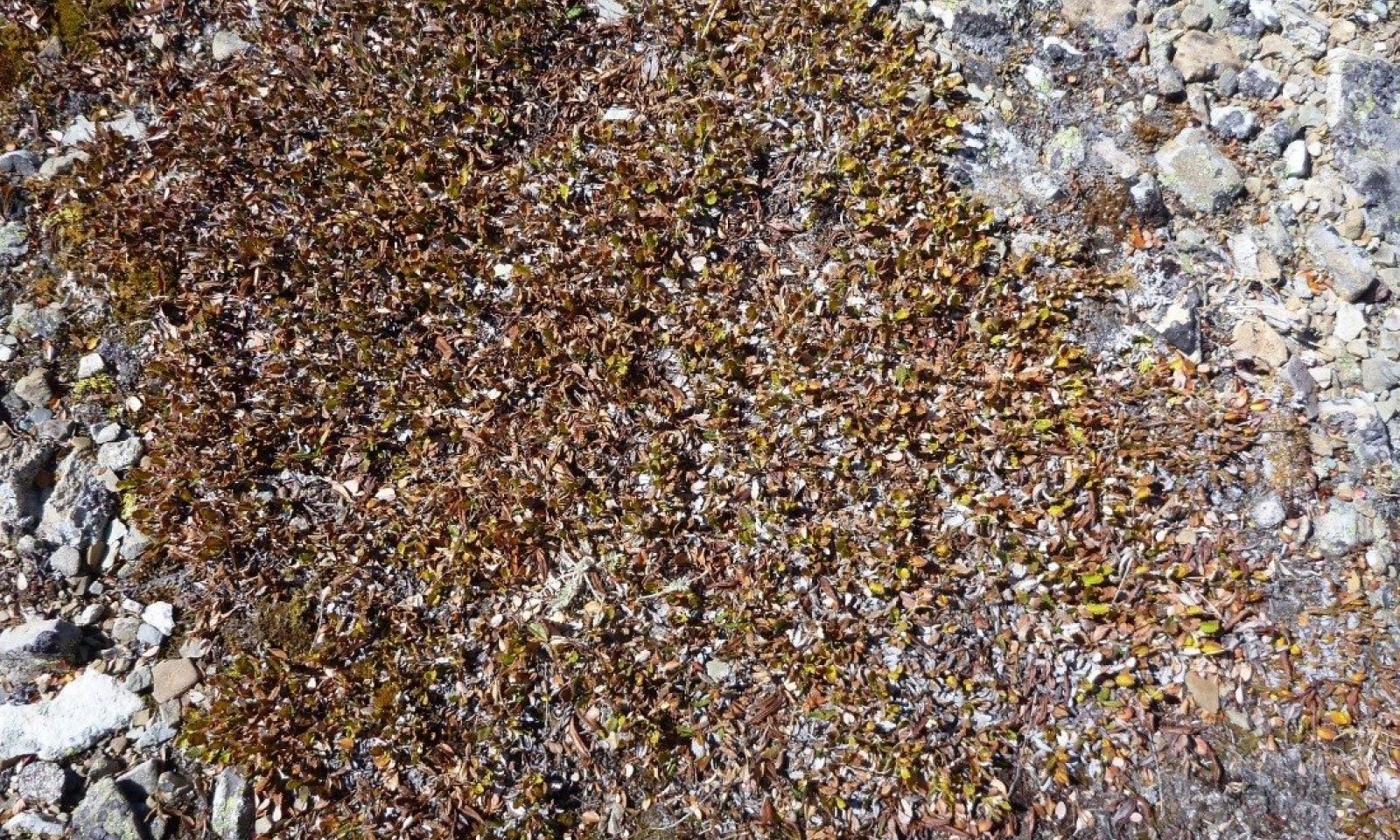
Figure 14. Close up of vegetated area of solifluction terrace at Siyeh Pass.
This community is dominated by the low-growing Dryas octopetala, but can have high cover of Arctostaphylos uva-ursi and/or Salix arctica. All of these species are adapted to the harsh environment of the site. There are diverse snow-loving forb species that occur in low cover. As well, there is a low cover of Carex species, particularly Carex rupestris and Carex scirpoidea. As well, Juniperus horizontalis and Dryas drummondii can occur infrequently, but in moderate cover. Foliar cover is high (average 63%) and basal cover is high (average 41%) and dominated by Dryas octopetala (average 17%), Arctostaphylos uva-ursi (8%) and/or Salix arctica. The soil surface in the vegetated stripe is litter with soil underneath (14%) while in the gravel stripe is clearly gravel dominated. There is a low cover of moss (8%) and very low cover of bare soil (1%). The species composition for production in pounds per acre averages across all sites as dominantly eightpetal mountain-avens at 52 percent, kinnickinik at 33 percent, shrubby cinquefoil at 4 percent, arctic willow at 2 percent, mountain hairgrass is 1 percent, white sweetvetch is 1 percent.
Dominant plant species
-
eightpetal mountain-avens (Dryas octopetala), shrub
-
kinnikinnick (Arctostaphylos uva-ursi), shrub
-
arctic willow (Salix arctica), shrub
-
moss campion (Silene acaulis), shrub
-
twinflower sandwort (Minuartia obtusiloba), shrub
-
curly sedge (Carex rupestris), grass
-
alpine smelowskia (Smelowskia calycina), other herbaceous
-
cutleaf daisy (Erigeron compositus), other herbaceous
-
alpine bistort (Polygonum viviparum), other herbaceous
Figure 15. Annual production by plant type (representative values) or group (midpoint values)
Table 6. Soil surface cover
Tree basal cover 0% Shrub/vine/liana basal cover 0-10% Grass/grasslike basal cover 0-0% Forb basal cover 0-10% Non-vascular plants 0-10% Biological crusts 0-10% Litter 10-20% Surface fragments >0.25" and <=3" 10-50% Surface fragments >3" 0-10% Bedrock 0% Water 0% Bare ground 0-10% Table 7. Canopy structure (% cover)
Height Above Ground (ft) Tree Shrub/Vine Grass/
GrasslikeForb <0.5 – 10-50% 0-15% 0-15% >0.5 <= 1 – 10-50% 0-15% 0-15% >1 <= 2 – – – – >2 <= 4.5 – – – – >4.5 <= 13 – – – – >13 <= 40 – – – – >40 <= 80 – – – – >80 <= 120 – – – – >120 – – – – Community 1.2
Reduction in cover by 50% due to tramplingThis community has sustained either human trampling, heavy grazing or browsing, which has reduced the cover and vigor of species present in community phase 1.1.
Community 1.3
Post-fire herbaceous phaseThis community has sustained fire and is the herbaceous dominated phase with resprouting shrubs.
Pathway 1.1B
Community 1.1 to 1.2This pathway represents human trampling, heavy grazing or browsing for sustained periods of time.
Pathway 1.1A
Community 1.1 to 1.3This pathway represents fire disturbance.
Pathway 1.2A
Community 1.2 to 1.1This pathway represents a cessation of human trampling, heavy grazing or browsing for sustained periods of time.
Pathway 1.3A
Community 1.3 to 1.1This pathway represents a time since fire disturbance in which the resprouting shrubs have resumed the cover found in community phase 1.1.
State 2
AlteredClimate change will impact the Alpine Solifluction Terrace ecological site, because the resident species are highly adapted to this site, and change could impact the distribution of peripheral species, endemics, and rare species. The Montana Natural Heritage Program has designated this ecosystem as a S5, and state that it is likely to increase as perennial ice and snow disappear. Desiccation and loss of alpine turf may also increase this ecosystems occupancy. Lesica (2014) found that in moist-turf (dominated by Dryas octopetala, Salix reticulata, and Carex scirpoidea) sites in Glacier National Park (GNP), there was a decline in arctic-alpine plants over two decades, with an approximate increase in temperature of 0.6 and 0.7 degrees Celsius than the previous four decades. There was a greater decline in dicots than monocots, and plants more restricted to high elevations declined more than species with broader elevational amplitude. Lesica’s paper documented upward migration of low-elevation species and declines in high-elevation species, and stated that the fluctuations were associated with increased temperature rather than declines in precipitation.
Community 2.1
Loss of endemic speciesThis community has a loss of endemic, rare high elevation species and an increase in low elevation species.
Transition T1A
State 1 to 2This pathway represents climate change in which the Reference State plant composition is irreversibly changed with the warming temperatures reducing snowpack, increasing growing season length and summer drought, and therefore allowing invasion by associated site species. The amount of time this would take is unknown at this time.
Additional community tables
Table 8. Community 1.1 plant community composition
Group Common name Symbol Scientific name Annual production () Foliar cover (%) Forb1 Perennial and annual forbs – white sweetvetch HESU Hedysarum sulphurescens 0–100 0–3 pale agoseris AGGL Agoseris glauca 0–50 0–5 mountain deathcamas ZIEL2 Zigadenus elegans 0–50 0–5 sticky polemonium POVI Polemonium viscosum 0–50 0–1 yellow penstemon PECO6 Penstemon confertus 0–50 0–1 silky lupine LUSE4 Lupinus sericeus 0–50 0–1 field locoweed OXCA4 Oxytropis campestris 0–50 0–1 cutleaf anemone PUPAM Pulsatilla patens ssp. multifida 0–25 0–2 northern bedstraw GABO2 Galium boreale 0–10 0–2 strawberry FRAGA Fragaria – 0–5 milkvetch ASTRA Astragalus – 0–5 silvery lupine LUAR3 Lupinus argenteus – 0–4 Wallace's spikemoss SEWA Selaginella wallacei – 0–3 common yarrow ACMI2 Achillea millefolium – 0–3 locoweed OXYTR Oxytropis – 0–2 American thorow wax BUAM2 Bupleurum americanum – 0–2 fireweed CHAN9 Chamerion angustifolium – 0–2 bastard toadflax COUM Comandra umbellata – 0–1 draba DRABA Draba – 0–1 western showy aster EUCO36 Eurybia conspicua – 0–1 agoseris AGOSE Agoseris – 0–1 anemone ANEMO Anemone – 0–1 bracted lousewort PEBR Pedicularis bracteosa – 0–1 coiled lousewort PECO Pedicularis contorta – 0–1 Rocky Mountain goldenrod SOMU Solidago multiradiata – 0–1 Grass/Grasslike2 Grasses, sedges – mountain hairgrass VAAT2 Vahlodea atropurpurea 0–150 0–1 alpine fescue FEBR Festuca brachyphylla 0–50 0–2 prairie Junegrass KOMA Koeleria macrantha 0–50 0–2 rough fescue FECA4 Festuca campestris – 0–30 Idaho fescue FEID Festuca idahoensis – 0–5 sedge CAREX Carex – 0–5 brome BROMU Bromus – 0–2 Payson's sedge CAPA31 Carex paysonis – 0–1 curly sedge CARU3 Carex rupestris – 0–1 northern singlespike sedge CASC10 Carex scirpoidea – 0–1 alpine bluegrass POAL2 Poa alpina – 0–1 spike trisetum TRSP2 Trisetum spicatum – 0–1 Shrub/Vine3 Shrubs and subshrubs – kinnikinnick ARUV Arctostaphylos uva-ursi 0–1000 0–60 eightpetal mountain-avens DROC Dryas octopetala 0–1000 0–40 shrubby cinquefoil DAFR6 Dasiphora fruticosa 0–1000 0–10 arctic willow SAAR27 Salix arctica 0–250 0–10 twinflower sandwort MIOB2 Minuartia obtusiloba 0–50 0–2 sulphur-flower buckwheat ERUM Eriogonum umbellatum 0–50 0–1 slender mountain sandwort ARCA7 Arenaria capillaris 0–50 0–1 snow willow SANI8 Salix nivalis 0–30 0–3 pussytoes ANTEN Antennaria 0–30 0–1 creeping juniper JUHO2 Juniperus horizontalis – 0–10 rose ROSA5 Rosa – 0–5 varileaf cinquefoil PODI2 Potentilla diversifolia – 0–1 moss campion SIAC Silene acaulis – 0–1 creeping sibbaldia SIPR Sibbaldia procumbens – 0–1 Saskatoon serviceberry AMAL2 Amelanchier alnifolia – 0–1 rosy pussytoes ANRO2 Antennaria rosea – 0–1 Table 9. Community 1.1 forest understory composition
Common name Symbol Scientific name Nativity Height (ft) Canopy cover (%) Grass/grass-like (Graminoids)sedge CAREX Carex – – 0–15 rough fescue FECA4 Festuca campestris – – 2.6–12 northern singlespike sedge CASC10 Carex scirpoidea – – 8.8 curly sedge CARU3 Carex rupestris – – 0.1–5.3 dunhead sedge CAPH2 Carex phaeocephala – – 0.5–5 purple reedgrass CAPU Calamagrostis purpurascens – – 0.5–4.1 lesser blackscale sedge CAAT8 Carex atrosquama – – 3 alpine bluegrass POAL2 Poa alpina – – 0–3 mountain brome BRMA4 Bromus marginatus – – 0.5–3 alpine timothy PHAL2 Phleum alpinum – – 3 intermediate wheatgrass THIN6 Thinopyrum intermedium – – 3 Idaho fescue FEID Festuca idahoensis – – 0.1–2 mountain hairgrass VAAT2 Vahlodea atropurpurea – – 0.5–1 bluegrass POA Poa – – 0.5 inland bluegrass PONEI2 Poa nemoralis ssp. interior – – 0.1–0.5 fescue FESTU Festuca – – 0.5 prairie Junegrass KOMA Koeleria macrantha – – 0.5 alpine fescue FEBR Festuca brachyphylla – – 0.1–0.5 Bonneville shootingstar DOCO Dodecatheon conjugens – – 0.5 Payson's sedge CAPA31 Carex paysonis – – 0.5 brome BROMU Bromus – – 0.5 Pumpelly's brome BRINP5 Bromus inermis ssp. pumpellianus var. pumpellianus – – 0.1–0.4 clustered field sedge CAPR5 Carex praegracilis – – 0.4 Alaskan wheatgrass ELAL5 Elymus alaskanus – – 0.4 arctic bluegrass POAR2 Poa arctica – – 0.4 Sandberg bluegrass POSE Poa secunda – – 0.1–0.3 blackroot sedge CAEL3 Carex elynoides – – 0.3 spike sedge CANA2 Carex nardina – – 0.1–0.3 blackandwhite sedge CAAL6 Carex albonigra – – 0.1–0.3 Forb/Herbeightpetal mountain-avens DROC Dryas octopetala – – 0.5–85 common yarrow ACMI2 Achillea millefolium – – 0.1–15 Pacific anemone ANMU Anemone multifida – – 0.1–15 pussytoes ANTEN Antennaria – – 0.5–15 spike trisetum TRSP2 Trisetum spicatum – – 0.1–15 cinquefoil POTEN Potentilla – – 15 phlox PHLOX Phlox – – 15 lupine LUPIN Lupinus – – 15 vetch VICIA Vicia – – 0.5–15 Rocky Mountain goldenrod SOMU Solidago multiradiata – – 0–5.3 twinflower sandwort MIOB2 Minuartia obtusiloba – – 0.5–5.3 spiked woodrush LUSP4 Luzula spicata – – 0.1–5 silvery lupine LUAR3 Lupinus argenteus – – 0.3–5 pale agoseris AGGL Agoseris glauca – – 0.1–5 yellowdot saxifrage SABR6 Saxifraga bronchialis – – 0.3–5 moss campion SIAC Silene acaulis – – 0.1–5 field locoweed OXCA4 Oxytropis campestris – – 0.5–5 Missouri goldenrod SOMI2 Solidago missouriensis – – 1.5–3.9 mountain deathcamas ZIEL2 Zigadenus elegans – – 0.5–3.9 rosy pussytoes ANRO2 Antennaria rosea – – 3 stonecrop SEDUM Sedum – – 3 white thistle CIHO Cirsium hookerianum – – 3 alpine golden buckwheat ERFL4 Eriogonum flavum – – 3 western showy aster EUCO36 Eurybia conspicua – – 3 locoweed OXYTR Oxytropis – – 0.5–3 snow willow SANI8 Salix nivalis – – 0.3–3 milkvetch ASTRA Astragalus – – 0.5–3 silky lupine LUSE4 Lupinus sericeus – – 0.5–3 white sweetvetch HESU Hedysarum sulphurescens – – 0.1–3 agoseris AGOSE Agoseris – – 2 alpine bistort POVI3 Polygonum viviparum – – 0.1–2 slender cinquefoil POGR9 Potentilla gracilis – – 1.6 alpine smelowskia SMCA Smelowskia calycina – – 0.1–1.6 cushion buckwheat EROV Eriogonum ovalifolium – – 0.1–1.6 tufted fleabane ERCA2 Erigeron caespitosus – – 0.1–1.6 timber oatgrass DAIN Danthonia intermedia – – 0.1–1.5 narrowleaf arnica ARANT Arnica angustifolia ssp. tomentosa – – 0.5–1.5 nodding onion ALCE2 Allium cernuum – – 0.1–1 anemone ANEMO Anemone – – 0.5–1 cutleaf daisy ERCO4 Erigeron compositus – – 0.1–1 fleabane ERIGE2 Erigeron – – 0.1–1 northern bedstraw GABO2 Galium boreale – – 0.1–1 coiled lousewort PECO Pedicularis contorta – – 0.3–1 varileaf cinquefoil PODI2 Potentilla diversifolia – – 0.5–1 American bistort POBI6 Polygonum bistortoides – – 0.3–0.5 yellow penstemon PECO6 Penstemon confertus – – 0.5 bracted lousewort PEBR Pedicularis bracteosa – – 0.5 white locoweed OXSE Oxytropis sericea – – 0.4–0.5 ledge stonecrop RHINI Rhodiola integrifolia ssp. integrifolia – – 0.1–0.5 little yellow rattle RHMI13 Rhinanthus minor – – 0.5 cutleaf anemone PUPAM Pulsatilla patens ssp. multifida – – 0.5 Alberta saxifrage SAOC4 Saxifraga occidentalis – – 0.1–0.5 saxifrage SAXIF Saxifraga – – 0.1–0.5 spearleaf stonecrop SELA Sedum lanceolatum – – 0.1–0.5 western meadow-rue THOC Thalictrum occidentale – – 0.5 raceme pussytoes ANRA Antennaria racemosa – – 0.5 sandwort ARENA Arenaria – – 0.5 Indian paintbrush CASTI2 Castilleja – – 0.5 Virginia strawberry FRVI Fragaria virginiana – – 0.5 sweetvetch HEDYS Hedysarum – – 0.5 beautiful sandwort MIRU3 Minuartia rubella – – 0.4–0.5 Payson's draba DRPA Draba paysonii – – 0.3–0.5 field chickweed CEAR4 Cerastium arvense – – 0.5 shootingstar DODEC Dodecatheon – – 0.5 Rocky Mountain dwarf-primrose DOMO Douglasia montana – – 0.1–0.5 draba DRABA Draba – – 0.5 alpine pussytoes ANAL4 Antennaria alpina – – 0.5 slender mountain sandwort ARCA7 Arenaria capillaris – – 0.5 umber pussytoes ANUM Antennaria umbrinella – – 0.3–0.5 Nuttall's rockcress ARNU Arabis nuttallii – – 0.5 alpine milkvetch ASAL7 Astragalus alpinus – – 0.5 Wyoming besseya BEWY Besseya wyomingensis – – 0.5 Jones' columbine AQJO Aquilegia jonesii – – 0.5 aster ASTER Aster – – 0.5 American thorow wax BUAM2 Bupleurum americanum – – 0–0.5 bluebell bellflower CARO2 Campanula rotundifolia – – 0.1–0.5 smallflowered anemone ANPA Anemone parviflora – – 0.4 Asian forget-me-not MYAS2 Myosotis asiatica – – 0.4 Nuttall's sandwort MINUN2 Minuartia nuttallii ssp. nuttallii – – 0.4 elegant cinquefoil POCO13 Potentilla concinna – – 0.1–0.4 sheep cinquefoil POOV2 Potentilla ovina – – 0.1–0.3 alpine leafybract aster SYFO2 Symphyotrichum foliaceum – – 0.3 Ross' sandwort MIRO4 Minuartia rossii – – 0.1–0.3 hairy false goldenaster HEVI4 Heterotheca villosa – – 0.3 Indian milkvetch ASAU4 Astragalus australis – – 0.3 sandwort ARENA Arenaria – – 0.3 yellow columbine AQFL Aquilegia flavescens – – 0.1 Bourgov's milkvetch ASBO3 Astragalus bourgovii – – 0.1 pearly pussytoes ANAN2 Antennaria anaphaloides Native – 0.1 elegant stitchwort MIEL2 Minuartia elegans – – 0.1 onestem fleabane ERSI3 Erigeron simplex – – 0.1 buff fleabane EROC Erigeron ochroleucus – – 0.1 Eschscholtz's buttercup RAES Ranunculus eschscholtzii – – 0.1 Parry's silene SIPA4 Silene parryi – – 0.1 snow cinquefoil PONI2 Potentilla nivea – – 0.1 rocky ledge penstemon PEEL5 Penstemon ellipticus – – 0.1 Shrub/Subshrubkinnikinnick ARUV Arctostaphylos uva-ursi – – 0.5–85 arctic willow SAAR27 Salix arctica – – 2–35 shrubby cinquefoil DAFR6 Dasiphora fruticosa – – 0.1–20 creeping juniper JUHO2 Juniperus horizontalis – – 15 common juniper JUCO6 Juniperus communis – – 0.1–2.5 rose ROSA5 Rosa – – 0.5 willow SALIX Salix – – 0.5 Treesubalpine fir ABLA Abies lasiocarpa – – 0.1–15 whitebark pine PIAL Pinus albicaulis – – 0.5 lodgepole pine PICO Pinus contorta – – 0.5 Nonvascularlesser spikemoss SEDE2 Selaginella densa – – 5.8 spikemoss SELAG Selaginella – – 5 Table 10. Community 1.2 plant community composition
Group Common name Symbol Scientific name Annual production () Foliar cover (%) Table 11. Community 1.3 plant community composition
Group Common name Symbol Scientific name Annual production () Foliar cover (%) Table 12. Community 2.1 plant community composition
Group Common name Symbol Scientific name Annual production () Foliar cover (%) Interpretations
Supporting information
Other references
References
Agee, James K. 1993. Fire ecology of Pacific Northwest forests. Washington, DC: Island Press. 493 p.
Arno, Stephen F. Forest regions of Montana. Intermountain Forest and Range Experiment Station, 1979.
Asebrook, J. 2010. Glacier National Park: Eastside Grasslands Ecology Project
Butler, D. and G. Malanson. Periglacial patterned ground, Waterton-Glacier International Peace Park, Canada and USA. Z. Geomorph. N.F. 1989.33(1):43-57.
Cole, D. 1985. Recreational trampling effects on six habitat types in western Montana. Research paper INT-350.
Cole, D. Recreational trampling effects on six habitat types in western Montana. INT-350. USFS. Intermountain Research Station, Ogden U 84401. October 1985.
Damm, Christian. 2001. A phytosociological study of Glacier National Park, Montana, USA, with notes on the syntaxonomy of alpine vegetation in western North America.
Fagre, D., Butler D., Malanson G., Walsh S. The changing alpine treeline. Developments in Earth Surface Processes.
Gardner, J.S. & N.K. Jones (1985): Evidence for a Neoglacial advance of the Boundary Glacier, Banff National Park, Alberta.-Can. J. Earth Sci. 22:1753-1755.
Hansen, Paul L.; Pfister, Robert D.; Boggs, Keith; [and others]. 1995. Classification and management of Montana's riparian and wetland sites. Miscellaneous Publication No. 54. Missoula, MT: The University of Montana, School of Forestry, Montana Forest and Conservation Experiment Station. 646 p.
Lesica, P. Arctic-alpine plants decline over two decades in Glacier National Park, Montana, USA. Arctic, Antarctic, and Alpine Research, 2014. 46(2):327-332.
Montana Native Heritage Program. Ecological Systems Web page.
NatureServe, 2007. U.S. National Vegetation Classification Standard: Terrestrial Ecological Classifications. Waterton-Glacier International Peace Park, Local and Global Association Descriptions.
Soil Survey Staff. 2015. Illustrated guide to soil taxonomy. U.S. Department of Agriculture, Natural Resources Conservation Service, National Soil Survey Center, Lincoln, Nebraska.
USDA PLANTS. Web page.Approval
Kirt Walstad, 4/10/2025
Rangeland health reference sheet
Interpreting Indicators of Rangeland Health is a qualitative assessment protocol used to determine ecosystem condition based on benchmark characteristics described in the Reference Sheet. A suite of 17 (or more) indicators are typically considered in an assessment. The ecological site(s) representative of an assessment location must be known prior to applying the protocol and must be verified based on soils and climate. Current plant community cannot be used to identify the ecological site.
Author(s)/participant(s) Contact for lead author Date 12/18/2020 Approved by Approval date Composition (Indicators 10 and 12) based on Annual Production Indicators
-
Number and extent of rills:
-
Presence of water flow patterns:
-
Number and height of erosional pedestals or terracettes:
-
Bare ground from Ecological Site Description or other studies (rock, litter, lichen, moss, plant canopy are not bare ground):
-
Number of gullies and erosion associated with gullies:
-
Extent of wind scoured, blowouts and/or depositional areas:
-
Amount of litter movement (describe size and distance expected to travel):
-
Soil surface (top few mm) resistance to erosion (stability values are averages - most sites will show a range of values):
-
Soil surface structure and SOM content (include type of structure and A-horizon color and thickness):
-
Effect of community phase composition (relative proportion of different functional groups) and spatial distribution on infiltration and runoff:
-
Presence and thickness of compaction layer (usually none; describe soil profile features which may be mistaken for compaction on this site):
-
Functional/Structural Groups (list in order of descending dominance by above-ground annual-production or live foliar cover using symbols: >>, >, = to indicate much greater than, greater than, and equal to):
Dominant:
Sub-dominant:
Other:
Additional:
-
Amount of plant mortality and decadence (include which functional groups are expected to show mortality or decadence):
-
Average percent litter cover (%) and depth ( in):
-
Expected annual annual-production (this is TOTAL above-ground annual-production, not just forage annual-production):
-
Potential invasive (including noxious) species (native and non-native). List species which BOTH characterize degraded states and have the potential to become a dominant or co-dominant species on the ecological site if their future establishment and growth is not actively controlled by management interventions. Species that become dominant for only one to several years (e.g., short-term response to drought or wildfire) are not invasive plants. Note that unlike other indicators, we are describing what is NOT expected in the reference state for the ecological site:
-
Perennial plant reproductive capability:
Print Options
Sections
Font
AAAAOther
PrintThe Ecosystem Dynamics Interpretive Tool is an information system framework developed by the USDA-ARS Jornada Experimental Range, USDA Natural Resources Conservation Service, and New Mexico State University.
Accessibility statement