Natural Resources
Conservation Service
Ecological site F043AY538ID
Ashy Basalt Canyons and Plateaus
23-25" PZ Mesic
Clearwater Canyons
Last updated: 4/11/2025
Accessed: 07/22/2026
-
Search


Major Land Resource Area or ecological site by name and/or ID.
PreviousSectionsNextGeneral information
Provisional. A provisional ecological site description has undergone quality control and quality assurance review. It contains a working state and transition model and enough information to identify the ecological site.
MLRA notes
Major Land Resource Area (MLRA): 043A–Northern Rocky Mountains
Major Land Resource Area (MLRA): 043A–Northern Rocky Mountains
Description of MLRAs can be found in: United States Department of Agriculture, Natural Resources Conservation Service. 2006. Land Resource Regions and Major Land Resource Areas of the United States, the Caribbean, and the Pacific Basin. U.S. Department of Agriculture Handbook 296.
Available electronically at: http://www.nrcs.usda.gov/wps/portal/nrcs/detail/soils/ref/?cid=nrcs142p2_053624#handbookLRU notes
Most commonly found in LRU 43A08 (Clearwater Canyons). Significant areas also found in 43A07 (Eastern Columbia Plateau Embayments). Climate parameters were obtained from PRISM and other models for the area. Landscape descriptors are derived from USGS DEM products and their derivatives.
Classification relationships
Relationship to Other Established Classifications:
United States National Vegetation Classification (2008) – A3446 Ponderosa Pine / Shrub Understory Central Rocky Mt. Forest & Woodland Alliance
Washington Natural Heritage Program. Ecosystems of Washington State, A Guide to Identification, Rocchio and Crawford, 2015 – Northern Rocky Mountain Ponderosa Pine Woodland and Savanna
Description of Ecoregions of the United States, USFS PN # 1391, 1995 - M333 Northern Rocky Mt. Forest-Steppe-Coniferous Forest-Alpine Meadow Province
Level III and IV Ecoregions of WA, US EPA, June 2010 - 15r Okanogan – Colville Xeric Valleys & Foothills and 15s Spokane Valley Outwash Plains
This ecological site includes the following USDA Forest Service Plant Associations: PIPO/SYAL, PIPO/PHMA, and PIPO/SYOR. (Williams et. al. 1995)Ecological site concept
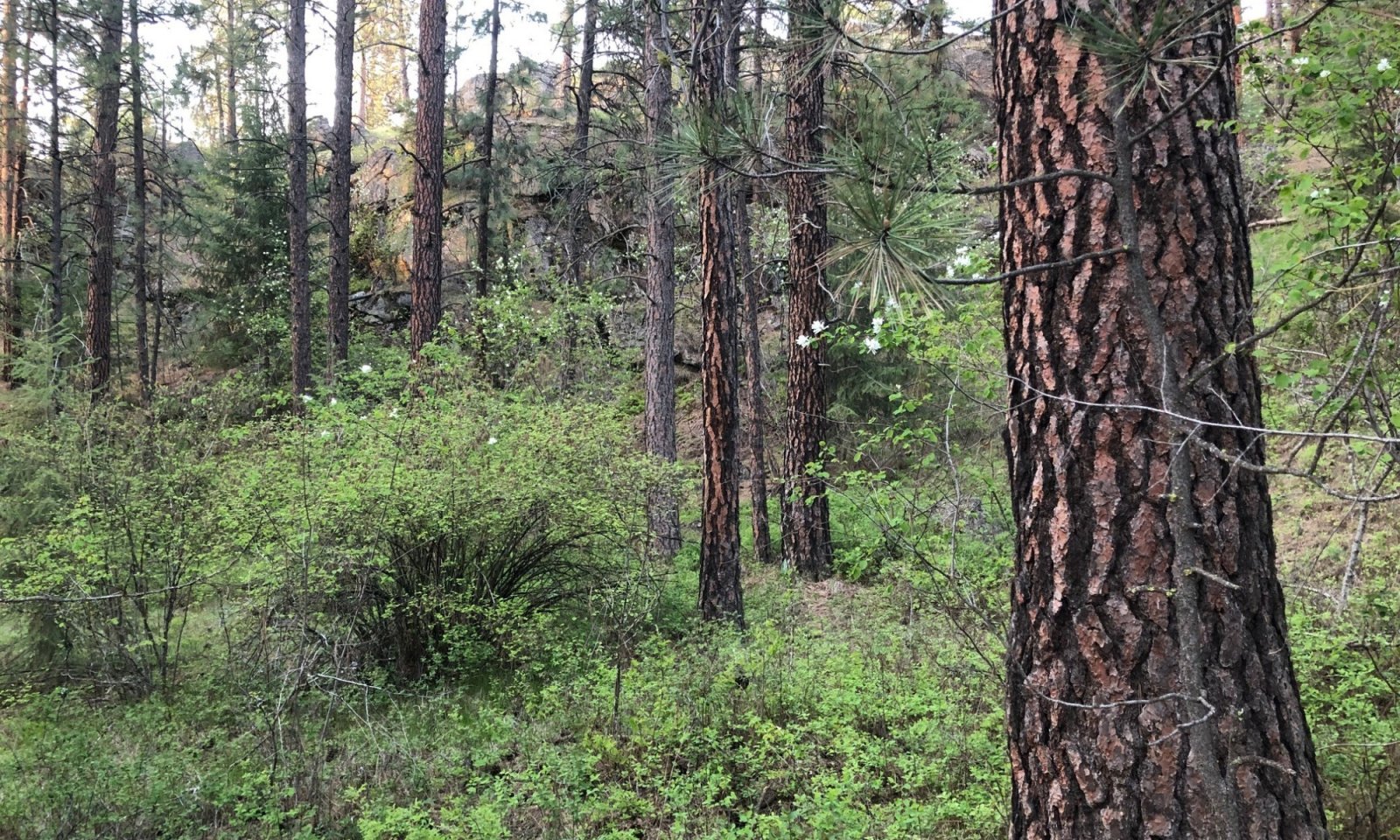
This ESD is distinguished by an overstory of ponderosa pine understory shrub component of ninebark, oceanspray, and snowberry. It occurs on canyon sides and structural benches. The soils have developed in mixed Mazama tephra deposits over loess and material from basalt. The soils are very deep, and some soils have a perched water table within 30 inches of the surface during the winter and early spring. They do not have a water table present within 30 inches of the surface during the May to Oct period. The soils are moderately well or well drained and have >3 inches of available water capacity in the top 40 inches. This ESD fits into the National Vegetation Standard’s Central Rocky Mt. Pinus ponderosa / Shrub Understory alliance.
Table 1. Dominant plant species
Tree (1) Pinus ponderosa
Shrub (1) Symphoricarpos albus
(2) Physocarpus malvaceusHerbaceous (1) Calamagrostis rubescens
(2) Achillea millefoliumPhysiographic features
Physiographic Features
Landscapes: Canyonlands, Plateaus
Landform: canyon walls, structural benches, escarpments
Elevation (m): Total range = 255 to 1015 m
(835 to 3,330 feet)
Central tendency = 525 to 770 m
(1,720 to 2,525 feet)
Slope (percent): Total range = 0 to 75 percent
Central tendency = 12 to 40 percent
Aspect: 25-205-335
Central tendency: 160-205-285Table 2. Representative physiographic features
Landforms (1) Canyonlands > Canyon wall
(2) Canyonlands > Structural bench
(3) Plateau > Escarpment
Flooding frequency None Ponding frequency None Elevation 1720 – 2525 ft Slope 12 – 40 % Water table depth 80 in Aspect W, S, SW Table 3. Representative physiographic features (actual ranges)
Flooding frequency None Ponding frequency None Elevation 835 – 3330 ft Slope 0 – 70 % Water table depth 37 – 80 in Climatic features
Climatic Features
Frost-free period (days): Total range = 105 to 130 days
Central tendency = 110 to 120 days
Mean annual precipitation (cm): Total range = 420 to 910 mm
(17 to 36 inches)
Central tendency = 605 to 740 mm
(24 to 29 inches)
MAAT (C): Total range = 7.9 to 11.9 C
(46 to 53 F)
Central tendency = 8.9 to 10.2 C
(48 to 50 F)
Climate Stations: Kamiah, Kooskia, Kooskia 5 SSE, Orofino 3 E">Influencing water features
Water Table Depth (cm):<br />
94 – >200 cm (median = >200 cm)<br />
(37 – 80 inches; median = >80 inches)<br />
<br />
Flooding: <br />
Frequency: None <br />
Duration: None<br />
<br />
Ponding: <br />
Frequency: None <br />
Duration: NoneSoil features
Representative Soil Features
This ecological subsite is associated with several soil series. The soils are Driscoll, Gibbs, Jacket, Keuterville, Kooskia, and Larkin. They are members of the Ultic Argixerolls, Pachic Ultic Argixerolls, Ultic Palexerolls, Vitrandic Argixerolls, and Xeric Argialbolls subgroups. These soils have developed in mixed Mazama tephra deposits over loess and material from basalt. The soils are very deep, and some soils have a perched water table within 30 inches of the surface during the winter and early spring. They do not have a water table present within 30 inches of the surface during the May to Oct period. The soils are moderately well or well drained.Table 4. Representative soil features
Parent material (1) Volcanic ash
(2) Loess
(3) Residuum – basalt
(4) Colluvium – basalt
Surface texture (1) Silt loam
(2) Gravelly silt loam
(3) Ashy silt loam
Drainage class Well drained Permeability class Moderately slow Depth to restrictive layer 80 in Available water capacity
(0-40in)7.2 in Calcium carbonate equivalent
(0-40in)Not specified Electrical conductivity
(0-40in)Not specified Soil reaction (1:1 water)
(0-60in)6.7 Subsurface fragment volume <=3"
(10-60in)Not specified Subsurface fragment volume >3"
(10-60in)Not specified Table 5. Representative soil features (actual values)
Drainage class Moderately well drained to well drained Permeability class Moderately slow to slow Depth to restrictive layer 8 – 80 in Available water capacity
(0-40in)5.6 – 8.2 in Calcium carbonate equivalent
(0-40in)0 % Electrical conductivity
(0-40in)0 mmhos/cm Soil reaction (1:1 water)
(0-60in)5.6 – 7.3 Subsurface fragment volume <=3"
(10-60in)0 – 30 % Subsurface fragment volume >3"
(10-60in)0 – 35 % Ecological dynamics
Ecological Dynamics of the Site
This site is located on foot slopes and side slopes of hills, canyons and low mountains. It is on sites with more moisture than the pine/dry grass sites. Most of this site occurs under 2800’ of elevation. Reference state is characteristic of mature pine stands over snowberry, serviceberry, spirea, chokecherry, woods rose, nutka rose, and ninebark. Redstem ceanothus may be present as evidence of past fires. Fire disturbance is sporadic and currently in the mixed severity or stand replacing regimes. It would not be considered in the pine/savanna category due to lack of frequent ground fires. Overstory canopy cover of these mature pine stands will range from 40 – 60%. These mature pine stands will be subject to bark beetle kill, windfall, and fire. The understory shrubs will resprout quickly and pine regeneration will be dependent on pine seed placement and shrub competition.
The pine/snowberry plant association will be located on the drier topographic locations and the pine/ninebark plant association will be located on northern aspects. These sites have been subject to overgazing, introduced grass seeding and land conversion. Kentucky bluegrass and Canada bluegrass have invaded many of these sites dominating the understory. Sites on less sloping terrain may have been converted to crops, pasture, or urban land.State and transition model
Custom diagramStandard diagram
More interactive model formats are also available. View Interactive Models
More interactive model formats are also available. View Interactive Models
Click on state and transition labels to scroll to the respective textEcosystem states
State 1 submodel, plant communities
State 2 submodel, plant communities
State 1
Reference
This state is relatively stable with long fire intervals maintaining a mature stand of ponderosa pine over a host of shrubs. Pine regeneration after any type of disturbance creating understory gaps will be variable due to shrub competition. Western pine beetle kill and windfall will create snags and down wood.
Characteristics and indicators. Mature pine stand with canopy coverage from 40 – 60% allowing dense understory coverage of shrubs with snowberry the most abundant and ninebark on moister sites. Little or no pine regeneration present due to shrub competition. Fire return intervals could be 100+ years. With minimal disturbance this phase maintained for long periods.
Community 1.1
Reference Community
Mature pine stand with canopy coverage from 40 – 60% allowing dense understory coverage of shrubs with snowberry the most abundant and ninebark on moister sites. Little or no pine regeneration present due to shrub competition. Fire return intervals could be 100+ years. With minimal disturbance this phase maintained for long periods.
Dominant plant species
-
ponderosa pine (Pinus ponderosa), tree
-
common snowberry (Symphoricarpos albus), shrub
-
Saskatoon serviceberry (Amelanchier alnifolia), shrub
-
white spirea (Spiraea betulifolia), shrub
-
chokecherry (Prunus virginiana), shrub
-
Woods' rose (Rosa woodsii), shrub
-
mallow ninebark (Physocarpus malvaceus), shrub
-
Cascara buckthorn (Frangula purshiana), shrub
-
redstem ceanothus (Ceanothus sanguineus), shrub
-
bluebunch wheatgrass (Pseudoroegneria spicata), grass
-
pinegrass (Calamagrostis rubescens), grass
-
blue wildrye (Elymus glaucus), grass
-
bluegrass (Poa), grass
-
common yarrow (Achillea millefolium), other herbaceous
-
strawberry (Fragaria), other herbaceous
-
sweetcicely (Osmorhiza berteroi), other herbaceous
-
Geyer's sedge (Carex geyeri), other herbaceous
Community 1.2
Understory ReinitiationShrub understory reestablishes from openings created with pine stand mortality from stand competition, beetle kill, root rot, or windfall. Snags and downed wood occur on site. Little or no pine regeneration due to shrub competition.
Community 1.3
Stem ExclusionDense pole stage pine stand. Experiences mortality from stand competition. Shrub dominated areas may exist interspersed within the pine stand.
Community 1.4
Stand InitiationStand replacing fire. Shrubs reestablish quickly. Pine regeneration dependent on seed year, moisture, and exposed mineral soil. A pine-shrub mosaic may develop dependent on pine – shrub completion dynamics.
Pathway 1.1A
Community 1.1 to 1.4Stand replacing fire where mineral soil exposed for pine regeneration. Shrubs reestablish quickly to compete with pine establishment.
Key drivers
-
Fire
Pathway 1.2A
Community 1.2 to 1.1Time. Mature stand maintained with minimal disturbance
Pathway 1.3A
Community 1.3 to 1.2Shrub understory reestablishes from openings created with pine stand mortality from stand competition, beetle kill, root rot, or windfall. Snags and downed wood occur on site. Little or no pine regeneration due to shrub competition.
Key drivers
-
Fire frequency
Pathway 1.4A
Community 1.4 to 1.3Dense pine stands develop in areas of good pine regeneration after fire.
Key drivers
-
Fire
State 2
Invaded
This state developed from past overgrazing or other disturbance and where Kentucky bluegrass and/or Canada bluegrass invaded from adjacent areas. Shrub coverage is low. A mature stand of pine usually exists.
Community 2.1
Reference
This state developed from past overgrazing or other disturbance and where Kentucky bluegrass and/or Canada bluegrass can invade from adjacent areas. Shrub coverage is low. Domestic spp may have been broadcast into sward to increase forage production. A mature stand of pine often exists.
Dominant plant species
-
ponderosa pine (Pinus ponderosa), tree
-
common snowberry (Symphoricarpos albus), shrub
-
bluegrass (Poa), grass
-
smooth brome (Bromus inermis), grass
-
orchardgrass (Dactylis glomerata), grass
State 3
Converted
Much of this Ecological Site is located at lower elevations where humans (Native and European) settled. These areas were converted to homesteads, pastures, and cropland. In recent times urban expansion has converted these sites to housing developments, shopping malls, and/or business centers.
Transition T1A
State 1 to 2
Reference
InvadedInvasion of introduce cool season grasses from overgrazing or seeding.
Key drivers
-
Livestock grazing or browsing
-
Nonnative plant species presence and/or establishment
-
Seeding
Transition T1B
State 1 to 3
Reference
ConvertedLand converted to crop, pasture or urban land
Key drivers
-
Mechanical soil disturbance
-
Seeding
Restoration pathway R2A
State 2 to 1
Invaded
ReferenceIntense site preparation to kill cool season introduced grasses. Native shrub and grass seeding needed if native vegetation is sparse.
Additional community tables
Table 6. Community 1.1 plant community composition
Group Common name Symbol Scientific name Annual production () Foliar cover (%) Table 7. Community 1.2 plant community composition
Group Common name Symbol Scientific name Annual production () Foliar cover (%) Table 8. Community 1.3 plant community composition
Group Common name Symbol Scientific name Annual production () Foliar cover (%) Table 9. Community 1.4 plant community composition
Group Common name Symbol Scientific name Annual production () Foliar cover (%) Table 10. Community 2.1 plant community composition
Group Common name Symbol Scientific name Annual production () Foliar cover (%) Interpretations
Supporting information
References
-
. 1998. NRCS National Forestry Manual.
-
. 2017. NRCS Soil and Site Index data for NE WA and N. Idaho.
-
Cooper, S.V., K.E. Neiman, R. Steele, and D.W. Roberts. 1991. Forest Habitat types of Northern Idaho, A Second Approximation.
-
Daubenmire, R. and J. Daubenmire. 1968. Forest Vegetation of Eastern Washington and Northern Idaho.
-
Smith and Fischer. 1997. Fire Ecology of the Forest Habitat Types of Northern Idaho.
-
Williams, C.K., B.F. Kelley, B.G. Smith, and T.R. Lillybridge. October, 1995. Forested Plant Associations of the Colville National Forest.
-
Zack, A. 1997. Biophysical Classification- Habitat Groups and Description of Northern Idaho and Northwestern Montana, Lower Clarkfork and Adjacent Areas..
Approval
Kirt Walstad, 4/11/2025
Rangeland health reference sheet
Interpreting Indicators of Rangeland Health is a qualitative assessment protocol used to determine ecosystem condition based on benchmark characteristics described in the Reference Sheet. A suite of 17 (or more) indicators are typically considered in an assessment. The ecological site(s) representative of an assessment location must be known prior to applying the protocol and must be verified based on soils and climate. Current plant community cannot be used to identify the ecological site.
Author(s)/participant(s) Contact for lead author Date 12/18/2020 Approved by Approval date Composition (Indicators 10 and 12) based on Annual Production Indicators
-
Number and extent of rills:
-
Presence of water flow patterns:
-
Number and height of erosional pedestals or terracettes:
-
Bare ground from Ecological Site Description or other studies (rock, litter, lichen, moss, plant canopy are not bare ground):
-
Number of gullies and erosion associated with gullies:
-
Extent of wind scoured, blowouts and/or depositional areas:
-
Amount of litter movement (describe size and distance expected to travel):
-
Soil surface (top few mm) resistance to erosion (stability values are averages - most sites will show a range of values):
-
Soil surface structure and SOM content (include type of structure and A-horizon color and thickness):
-
Effect of community phase composition (relative proportion of different functional groups) and spatial distribution on infiltration and runoff:
-
Presence and thickness of compaction layer (usually none; describe soil profile features which may be mistaken for compaction on this site):
-
Functional/Structural Groups (list in order of descending dominance by above-ground annual-production or live foliar cover using symbols: >>, >, = to indicate much greater than, greater than, and equal to):
Dominant:
Sub-dominant:
Other:
Additional:
-
Amount of plant mortality and decadence (include which functional groups are expected to show mortality or decadence):
-
Average percent litter cover (%) and depth ( in):
-
Expected annual annual-production (this is TOTAL above-ground annual-production, not just forage annual-production):
-
Potential invasive (including noxious) species (native and non-native). List species which BOTH characterize degraded states and have the potential to become a dominant or co-dominant species on the ecological site if their future establishment and growth is not actively controlled by management interventions. Species that become dominant for only one to several years (e.g., short-term response to drought or wildfire) are not invasive plants. Note that unlike other indicators, we are describing what is NOT expected in the reference state for the ecological site:
-
Perennial plant reproductive capability:
Print Options
Sections
Font
AAAAOther
PrintThe Ecosystem Dynamics Interpretive Tool is an information system framework developed by the USDA-ARS Jornada Experimental Range, USDA Natural Resources Conservation Service, and New Mexico State University.
Accessibility statement