Natural Resources
Conservation Service
Ecological site F043AY535ID
Loamy Canyons and Terraces
23-25" PZ Mesic
Clearwater Canyons
Last updated: 4/09/2025
Accessed: 07/12/2026
-
Search


Major Land Resource Area or ecological site by name and/or ID.
PreviousSectionsNextGeneral information
Provisional. A provisional ecological site description has undergone quality control and quality assurance review. It contains a working state and transition model and enough information to identify the ecological site.
MLRA notes
Major Land Resource Area (MLRA): 043A–Northern Rocky Mountains
Major Land Resource Area (MLRA): 043A–Northern Rocky Mountains
Description of MLRAs can be found in: United States Department of Agriculture, Natural Resources Conservation Service. 2006. Land Resource Regions and Major Land Resource Areas of the United States, the Caribbean, and the Pacific Basin. U.S. Department of Agriculture Handbook 296.
Available electronically at: http://www.nrcs.usda.gov/wps/portal/nrcs/detail/soils/ref/?cid=nrcs142p2_053624#handbookLRU notes
Most commonly found in LRU 43A08 (Clearwater Canyons). Also present in 43A09 (Western Bitterroot Foothills), and 43A07 (Eastern Columbia Plateau Embayments). Climate parameters were obtained from PRISM and other models for the area. Landscape descriptors are derived from USGS DEM products and their derivatives.
Classification relationships
Relationship to Other Established Classifications:
United States National Vegetation Classification (2008) – A3447 Ponderosa Pine / Herbaceous Understory Central Rocky Mt. Forest & Woodland Alliance
Washington Natural Heritage Program. Ecosystems of Washington State, A Guide to Identification, Rocchio and Crawford, 2015 – Northern Rocky Mountain Ponderosa Pine Woodland and Savanna
Description of Ecoregions of the United States, USFS PN # 1391, 1995 - M332 Middle Rocky Mt. Forest-Steppe-Coniferous Forest-Alpine Meadow Province
Level III and IV Ecoregions of WA, US EPA, June 2010 - 15r Okanogan – Colville Xeric Valleys & Foothills and 15s Spokane Valley Outwash Plains
This ecological site includes the following USDA Forest Service Plant Associations: PIPO/PSSP, PIPO/FEID, and PIPO-PSME/PSSP. (Williams et. al. 1995)Ecological site concept
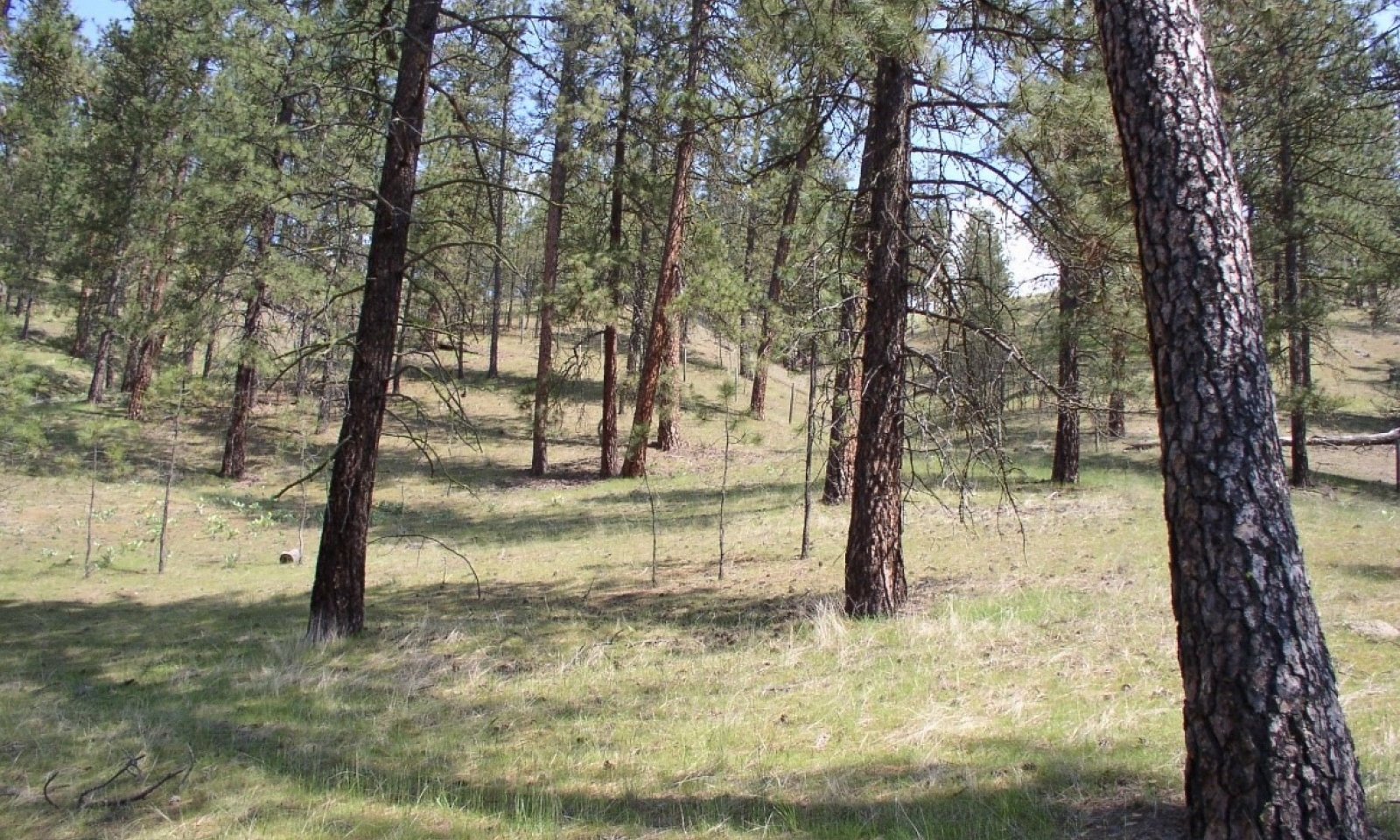
This ESD is distinguished by an overstory of Ponderosa pine. Understory is grass dominated. Grass species are dominantly bluebunch wheatgrass and Idaho fescue. Forbs include arrowleaf balsamroot, sticky geranium, yarrow and lupine.. It occurs on foothills, canyon sides, and terraces. Soils are loamy with moderate to high available water capacity. Water tables are at >30 inches and drainage class is moderately well to well drained. This ESD fits into the National Vegetation Standard’s Ponderosa Pine / Herbaceous Understory Central Rocky Mt. Forest & Woodland Alliance and Washington State’s Natural Heritage Program’s Northern Rocky Mountain Ponderosa Pine Woodland and Savanna.
Table 1. Dominant plant species
Tree (1) Pinus ponderosa
Shrub Not specified
Herbaceous (1) Pseudoroegneria spicata
(2) Festuca idahoensisPhysiographic features
Physiographic Features
Landscapes: Canyonlands
Landform: canyon walls, stream terraces
Elevation (m): Total range = 295 to 1285 m
(965 to 4,210 feet)
Central tendency = 540 to 840 m
(1,770 to 2,755 feet)
Slope (percent): Total range = 0 to 90 percent
Central tendency = 12 to 45 percent
Aspect (degrees):
100-225-40
Central tendency = 160-225-290Table 2. Representative physiographic features
Landforms (1) Canyonlands > Canyon wall
(2) Canyonlands > Stream terrace
Climatic features
Climatic Features
Frost-free period (days): Total range = 90 to 160 days
Central tendency = 110 to 135 days
Mean annual precipitation (cm): Total range = 455 to 945 mm
(18 to 37 inches)
Central tendency = 600 to 740 mm
(24 to 29 inches)
MAAT Total range = 6.0 to 11.5 C
(43 to 53 F)
Central tendency = 7.9 to 9.8 C
(46 to 50 F)
Climate Stations: Dworshak Dam, Dworshak Fish Hatchery, Orofino, Orofino Telemark">Influencing water features
Water Table Depth (cm): 76 to >200 cm (30 to >80 inches)<br />
Median = >200cm(>80 inches)<br />
<br />
Flooding: <br />
Frequency: None <br />
Duration: None<br />
Ponding: <br />
Frequency: None <br />
Duration: NoneSoil features
Representative Soil Features
This ecological subsite is associated with several soil series (e.g. Ahsahka, Fordcreek, Itzee, Larkin, Southwick, Tekoa, Texascreek). The soil components can be grouped into Cumulic Ultic Haploxerolls, Typic Argixerolls, Ultic Argixerolls, Ultic Haploxeralfs, and Ultic Haploxerolls. These soils have developed in mixed material from granite, quartzite, loess and alluvium with a volcanic ash influence. The soils are moderately deep to very deep and have moderate available water capacity to a depth of 1 m. The soils are mostly well drained.
Fragment content of surface layers (% Volume)Table 3. Representative soil features
Parent material (1) Loess
(2) Alluvium
(3) Colluvium – granite
(4) Colluvium – quartzite
(5) Residuum – granite
(6) Residuum – quartzite
Surface texture (1) Gravelly silt loam
(2) Silt loam
(3) Loam
Drainage class Well drained Permeability class Moderate Depth to restrictive layer 80 in Surface fragment cover >3" Not specified Available water capacity
(0-40in)7 in Calcium carbonate equivalent
(0-60in)Not specified Electrical conductivity
(0-60in)Not specified Soil reaction (1:1 water)
(0-60in)6.5 Subsurface fragment volume <=3"
(10-60in)30 % Subsurface fragment volume >3"
(10-60in)9 % Table 4. Representative soil features (actual values)
Drainage class Moderately well drained to somewhat excessively drained Permeability class Moderate to rapid Depth to restrictive layer 20 – 80 in Surface fragment cover >3" 0 – 9 % Available water capacity
(0-40in)3.1 – 7.2 in Calcium carbonate equivalent
(0-60in)0 % Electrical conductivity
(0-60in)0 mmhos/cm Soil reaction (1:1 water)
(0-60in)5.6 – 7.3 Subsurface fragment volume <=3"
(10-60in)0 – 35 % Subsurface fragment volume >3"
(10-60in)0 – 30 % Ecological dynamics
Ecological Dynamics of the Site
This reference site is located on very warm dry slopes with ponderosa pine the only tree species with an understory of mainly bluebunch wheatgrass, Idaho Fescue, and some needle and thread grass. Tree stocking is low with large open grown ponderosa pine and small amounts of sapling/pole size pine in understory. Frequent ground fires every 10-15 years kept pine regeneration low and perpetuated this condition with a dominant grass understory. With fire exclusion a mosaic of pine cohorts underneath the large pine survive and a patchy woodland develops. In addition, some woodland shrubs may establish and an occasional Douglas-fir may be present. Stands in this altered state are subject to beetle kill and mistletoe infestation. Soils are mainly sandy loams or loamy sands. The main habitat types included in this ecological site are Ponderosa pine/blunchwheat grass and Ponderosa pine/Idaho fescue.. The bluebunch wheatgrass sites occur on the warmer drier slopes and the Idaho fescue sites occur on the lower slopes and more level terrain. Both habitat types have similar ecological processes as described above. The fescue sites will have more pine stand density due to a little more moisture and topographic position.State and transition model
Custom diagramStandard diagram
More interactive model formats are also available. View Interactive Models
More interactive model formats are also available. View Interactive Models
Click on state and transition labels to scroll to the respective textEcosystem states
State 1 submodel, plant communities
State 2 submodel, plant communities
State 1
Reference
This state is dependent on the occurrence of frequent low intensity ground fires keeping an open grown pine stand with a dominant ground cover of bunchgrass. When fire intervals are infrequent pine regeneration can survive and a patchy pine woodland develops underneath the large old pine. With drought stress the large old pine can be subject to beetle kill and the understory pine stands subject to dwarf mistletoe infestation. It is also possible to have a stand replacement fire when stand density is increased and ladder fuels can reach the larger pine crowns.
Forest productivity is measured using site index (SI) and culmination of annual increment (CMAI). Ponderosa pine is the key tree species and site indexes ranges greatly depending on local site characteristics. Available data indicates a mean site index of 100 using (Meyer, 1961) with a CMAI of 102 cu. ft./yr at age 40 years.
The bulk of grass production is bluebunch wheatgrass and Idaho fescue. Other grass species included needle and thread grass, prairie junegrass, rough fescue, pine grass and sandberg bluegrass. The most prominent forbs were lupine, basalmroot, pussytoes, hawkweed, and yarrow. Shrubs tend to be present in only trace amounts. Tree regeneration is mostly ponderosa pine with an occasional Douglas-fir.Community 1.1
Reference Community
Large open grown pine with bunchgrass understory. Pine canopy coverage may range from 10 – 30%. Understory dominated by bluebunch wheat grass on the drier sites and Idaho fescue on the moister sites. Other key understory species include arrowleaf basalmroot, western yarrow, buckwheat, and needle and thread grass.
Dominant plant species
-
ponderosa pine (Pinus ponderosa), tree
-
buckwheat (Eriogonum), shrub
-
bluebunch wheatgrass (Pseudoroegneria spicata), grass
-
Idaho fescue (Festuca idahoensis), grass
-
needle and thread (Hesperostipa comata), grass
-
pinegrass (Calamagrostis rubescens), grass
-
prairie Junegrass (Koeleria macrantha), grass
-
Sandberg bluegrass (Poa secunda), grass
-
lupine (Lupinus), other herbaceous
-
arrowleaf balsamroot (Balsamorhiza sagittata), other herbaceous
-
pussytoes (Antennaria), other herbaceous
-
common yarrow (Achillea millefolium), other herbaceous
-
white hawkweed (Hieracium albiflorum), other herbaceous
Community 1.2
Understory Re-initiation Phase
Understory pine starts to establish. Bunchgrass cover reduced. Woodland shrubs and fir may establish at higher elevations.
Community 1.3
Understory Stem Exclusion PhaseUnderstory pine stands start to decline through competition. Snags and woody debris develop. Beetle kill possible. Stand susceptible to stand replacing fire with possible large old pine killed. Mixed severity fire will thin out understory pine stand, woodland shrubs and kill fir regeneration. Bunchgrass cover will increase.
Community 1.4
Stand Initiation Phase
Understory pine stand killed by fire, some larger overstory pine killed. Bunchgrass cover increased. Sporadic pine regeneration dependent on moisture, topographic position, and good seed crop years.
Pathway 1.1B
Community 1.1 to 1.2
Reference Community
Understory Re-initiation PhaseTime. Lack of fire allowing pine regeneration to survive in a patchy mosaic underneath overystory pine. Some woodland shrubs like snowberry, serviceberry, chokecherry and rose species may establish. Occasionally a Douglas-fir may establish in this condition. A mixed severity fire will thin out the understory pine stand and kill the shrubs and Douglas-fir.
Pathway 1.2B
Community 1.2 to 1.1
Understory Re-initiation Phase
Reference CommunityGround fires reoccur returning site to open pine/grass site
Pathway 1.2A
Community 1.2 to 1.3Time, continued lack of fire allowing pine cohorts to form dense stands.
Pathway 1.3A
Community 1.3 to 1.4Stand replacing fire, dense understory pine stands killed, some large overstory pine survive
Pathway 1.4A
Community 1.4 to 1.1
Stand Initiation Phase
Reference CommunityNatural fire interval resumes, maintaining open pine stand with abundant bunchgrass.
Pathway 1.4B
Community 1.4 to 1.2
Stand Initiation Phase
Understory Re-initiation PhaseLack of reoccurring fire causing increase in pine establishment.
State 2
Fire Exclusion
Fire Exclusion for 50+ years leads to a light to medium dense pine woodland with all ages present. Canopy cover ranges from 30- 60%. Canopy cover will be higher in the pine/fescue habitat. Mixed severity fires will create a mosaic of pine stands between burned areas which will seed in with pine maintaining a multi-level pine woodland.
Community 2.1
Plant Community Phase 2.1Reference phase depicted by multi-level pine stand with scattered old pine over all aged pine. Stand density light to medium in patchwork of pine cohorts of large old pine.
State 3
InvadedInvasion of introduced perennial and annual cool season grasses from adjacent pastures, homesteads, and abandoned areas. One particular annual grass of concern from past overgrazing is the invasion of cheat grass. Once it gets established in the understory it will prevent native bunchgrasses from reestablishing and restoring site.
State 4
ConvertedLower level terrain converted to crops, pasture or urban development. Much of the ponderosa pine ESDs are adjacent to local towns and cities. They have been converted to housing developments, shopping malls, or urban recreation areas. In the more rural areas, these sites have been converted to pastures and dry or irrigated cropland.
Transition T1A
State 1 to 2
Reference
Fire ExclusionThe natural fire regime intervals changed to 50+ years allowing understory pine regeneration to survive and grow creating more of a woodland site. Older larger pine now more susceptible to mortality from stand replacing fire.
Transition T1B
State 1 to 3Invasion of introduced perennial and annual grasses which outcompete native bunchgrasses
Transition T1C
State 1 to 4Land converted to crop, pasture, or urban development
Restoration pathway R2A
State 2 to 1
Fire Exclusion
ReferenceOverstory thinning and understory burning for specified time intervals to return site to Reference State 1.
Restoration pathway R3A
State 3 to 1Site preparation, native grass reseeding, weed control, grazing protection followed by prescribed burning after establishment to maintain site in reference plant community.
Additional community tables
Table 5. Community 1.1 plant community composition
Group Common name Symbol Scientific name Annual production () Foliar cover (%) Table 6. Community 1.2 plant community composition
Group Common name Symbol Scientific name Annual production () Foliar cover (%) Table 7. Community 1.3 plant community composition
Group Common name Symbol Scientific name Annual production () Foliar cover (%) Table 8. Community 1.4 plant community composition
Group Common name Symbol Scientific name Annual production () Foliar cover (%) Table 9. Community 2.1 plant community composition
Group Common name Symbol Scientific name Annual production () Foliar cover (%) Interpretations
Supporting information
References
-
. 1998. NRCS National Forestry Manual.
-
. 2017. NRCS Soil and Site Index data for NE WA and N. Idaho.
-
Cooper, S.V., K.E. Neiman, R. Steele, and D.W. Roberts. 1991. Forest Habitat types of Northern Idaho, A Second Approximation.
-
Daubenmire, R. and J. Daubenmire. 1968. Forest Vegetation of Eastern Washington and Northern Idaho.
-
Finklin, A.I. 1983. Climate of Priest River Experimental Forest, northern Idaho. Gen. Tech. Rep. INT-159. U.S. Department of Agriculture, Forest Service, Intermountain Forest and Range Experiment Station, Ogden, UT. 53.
-
Smith and Fischer. 1997. Fire Ecology of the Forest Habitat Types of Northern Idaho.
-
Williams, C.K., B.F. Kelley, B.G. Smith, and T.R. Lillybridge. October, 1995. Forested Plant Associations of the Colville National Forest.
-
Zack, A. 1997. Biophysical Classification- Habitat Groups and Description of Northern Idaho and Northwestern Montana, Lower Clarkfork and Adjacent Areas..
Approval
Kirt Walstad, 4/09/2025
Rangeland health reference sheet
Interpreting Indicators of Rangeland Health is a qualitative assessment protocol used to determine ecosystem condition based on benchmark characteristics described in the Reference Sheet. A suite of 17 (or more) indicators are typically considered in an assessment. The ecological site(s) representative of an assessment location must be known prior to applying the protocol and must be verified based on soils and climate. Current plant community cannot be used to identify the ecological site.
Author(s)/participant(s) Contact for lead author Date 12/18/2020 Approved by Approval date Composition (Indicators 10 and 12) based on Annual Production Indicators
-
Number and extent of rills:
-
Presence of water flow patterns:
-
Number and height of erosional pedestals or terracettes:
-
Bare ground from Ecological Site Description or other studies (rock, litter, lichen, moss, plant canopy are not bare ground):
-
Number of gullies and erosion associated with gullies:
-
Extent of wind scoured, blowouts and/or depositional areas:
-
Amount of litter movement (describe size and distance expected to travel):
-
Soil surface (top few mm) resistance to erosion (stability values are averages - most sites will show a range of values):
-
Soil surface structure and SOM content (include type of structure and A-horizon color and thickness):
-
Effect of community phase composition (relative proportion of different functional groups) and spatial distribution on infiltration and runoff:
-
Presence and thickness of compaction layer (usually none; describe soil profile features which may be mistaken for compaction on this site):
-
Functional/Structural Groups (list in order of descending dominance by above-ground annual-production or live foliar cover using symbols: >>, >, = to indicate much greater than, greater than, and equal to):
Dominant:
Sub-dominant:
Other:
Additional:
-
Amount of plant mortality and decadence (include which functional groups are expected to show mortality or decadence):
-
Average percent litter cover (%) and depth ( in):
-
Expected annual annual-production (this is TOTAL above-ground annual-production, not just forage annual-production):
-
Potential invasive (including noxious) species (native and non-native). List species which BOTH characterize degraded states and have the potential to become a dominant or co-dominant species on the ecological site if their future establishment and growth is not actively controlled by management interventions. Species that become dominant for only one to several years (e.g., short-term response to drought or wildfire) are not invasive plants. Note that unlike other indicators, we are describing what is NOT expected in the reference state for the ecological site:
-
Perennial plant reproductive capability:
Print Options
Sections
Font
AAAAOther
PrintThe Ecosystem Dynamics Interpretive Tool is an information system framework developed by the USDA-ARS Jornada Experimental Range, USDA Natural Resources Conservation Service, and New Mexico State University.
Accessibility statement