Natural Resources
Conservation Service
Ecological site F043AX960MT
Montane Deciduous Alluvial Flood Plain
black cottonwood (paper birch)/redosier dogwood
Populus balsamifera ssp. trichocarpa (Betula papyrifera)/Cornus sericea ssp. sericea
Last updated: 4/07/2025
Accessed: 07/10/2026
-
Search


Major Land Resource Area or ecological site by name and/or ID.
PreviousSectionsNextGeneral information
Provisional. A provisional ecological site description has undergone quality control and quality assurance review. It contains a working state and transition model and enough information to identify the ecological site.
MLRA notes
Major Land Resource Area (MLRA): 043A–Northern Rocky Mountains
This MLRA is located in Montana (43 percent), Idaho (34 percent), and Washington (23 percent). It makes up about 31,435 square miles (81,460 square kilometers). It has no large cities or towns. It has many national forests, including the Okanogan, Colville, Kootenai, Lolo, Flathead, Coeur d’Alene, St. Joe, Clearwater, and Kaniksu National Forests.
This MLRA is in the Northern Rocky Mountains Province of the Rocky Mountain System. It is characterized by rugged, glaciated mountains; thrust- and block-faulted mountains; and hills and valleys. Steep-gradient rivers have cut deep canyons. Natural and manmade lakes are common.
The major Hydrologic Unit Areas (identified by four-digit numbers) that make up this MLRA are: Kootenai-Pend Oreille-Spokane (1701), 67 percent; Upper Columbia (1702), 18 percent; and Lower Snake (1706), 15 percent. Numerous rivers originate in or flow through this area, including, the Sanpoil, Columbia, Pend Oreille, Kootenai, St. Joe, Thompson, and Flathead Rivers.
This area is underlain primarily by stacked slabs of layered sedimentary or metasedimentary bedrock. The bedrock formations range from Precambrian to Cretaceous in age. The rocks consist of shale, sandstone, siltstone, limestone, argillite, quartzite, gneiss, schist, dolomite, basalt, and granite. The formations have been faulted and stacked into a series of imbricate slabs by regional tectonic activity. Pleistocene glaciers carved a rugged landscape that includes sculpted hills and narrow valleys filled with till and outwash. Continental glaciation over road the landscape in the northern half of the MLRA while glaciation in the southern half was confined to montane settings.
The average annual precipitation is 25 to 60 inches (635 to 1,525 millimeters) in most of this area, but it is as much as 113 inches (2,870 millimeters) in the mountains and is 10 to 15 inches (255 to 380 millimeters) in the western part of the area. Summers are dry. Most of the precipitation during fall, winter, and spring is snow. The average annual temperature is 32 to 51 degrees F (0 to 11 degrees C) in most of the area, decreasing with elevation. In most of the area, the freeze-free period averages 140 days and ranges from 65 to 215 days. It is longest in the low valleys of Washington, and it decreases in length with elevation. Freezing temperatures occur every month of the year on high mountains, and some peaks have a continuous cover of snow and ice.
The dominant soil orders in this MLRA are Andisols, Inceptisols, and Alfisols. Many of the soils are influenced by Mount Mazama ash deposits. The soils in the area have a frigid or cryic soil temperature regime; have an ustic, xeric, or udic soil moisture regime; and dominantly have mixed mineralogy. They are shallow to very deep, are very poorly drained to well drained, and have most of the soil texture classes. The soils at the lower elevations include Udivitrands, Vitrixerands and Haplustalfs. The soils at the higher elevations include Dystrocryepts, Eutrocryepts, Vitricryands , and Haplocryalfs. Cryorthents, Cryepts, and areas of rock outcrop are on ridges and peaks above timberline
This area is in the northern part of the Northern Rocky Mountains. Grand fir, Douglas-fir, western red cedar, western hemlock, western larch, lodgepole pine, subalpine fir, ponderosa pine, whitebark pine, and western white pine are the dominant overstory species, depending on precipitation, temperature, elevation, and landform aspect. The understory vegetation varies, also depending on climatic and landform factors. Some of the major wildlife species in this area are whitetailed deer, mule deer, elk, moose, black bear, grizzly bear, coyote, fox, and grouse. Fish, mostly in the trout and salmon families, are abundant in streams, rivers, and lakes.
More than one-half of this area is federally owned and administered by the U.S. Department of Agriculture, Forest Service. Much of the privately-owned land is controlled by large commercial timber companies. The forested areas are used for wildlife habitat, recreation, watershed, livestock grazing, and timber production. Meadows provide summer grazing for livestock and big game animals. Less than 3 percent of the area is cropland.LRU notes
This ecological site resides in MLRA 43A in the Livingston-Lewis-Apgar Mountains which includes the bulk of Glacier National Park (GNP) and the lower western valley portions along the Flathead River. The landscape is mountains and landforms include glaciated mountains with associated features such as U-shaped valleys, mountain slopes, alpine ridges, cirques, valley floors and moraines. Glaciation of this area was in the form of alpine, icecaps and valley outlet glaciers. It also includes associated alluvium and outwash features. This area includes low valleys to tall mountains with elevation ranging 989-2,762 m (3,250-9,050 ft.). The climate is cold and wet with mean annual air temperature of 3 degrees Celsius (37 degrees F)., mean frost free days of 65 days and mean annual precipitation of 1295 mm (51 in.) and relative effective annual precipitation is 169 cm (66 in.). The soil temperature regime is cryic and the soil moisture regime is udic. The geology of this area is dominated by metasedimentary rocks of the Belt Supergroup (Grinnell argillite and Siyeh limestone) with minor Tertiary sediments. Soils are generally weakly developed on mountain slopes within U-shaped valleys. Parent materials are commonly of colluvium, till, and residuum from metasedimentary rocks. Limestone bedrock within this part of the Belt Supergroup is not highly calcareous and due to high precipitation received in this area most carbonates at mid and upper elevations have been leached from the soil profiles. Bedrock depth varies greatly with location, landform and slope position. Volcanic ash is often found in the soil surface with various degrees of mixing. Thicker volcanic ash can be found on more stable positions on mid and upper elevation slopes that are protected from wind erosion. Volcanic ash is not typically found in low elevation areas on stream and outwash terraces associated with streams and rivers. There are numerous large lakes including St. Mary, Bowman, Kintla, Lake Sherburne, Logging, Upper Waterton and numerous creeks (
Classification relationships
NPS Vegetation Map Name/NatureServe:
Populus balsamifera ssp. trichocarpa-(Populus tremuloides)/Heracleum maximum Forest CEGL000542Ecological site concept
Ecological Site Concept
This ecological site is found near large rivers on associated floodplains. These sites are flat with no associated aspect and range in elevation from 1,000-1,300 meters (3,280-4,265 feet). It occurs in wide alluvial valleys, drainageways and along tributaries. The valleys that these sites occur in have low slope and high stream sinuosity (Rosgen VIII C4). Stream sinuosity is not restricted by the valley side slopes. The valley type and stream channel type are valley 8 and stream C4, according to Rosgen. This means that the valleys are wide, flat, open and on alluvial landforms. The stream is slightly entrenched, moderate to high width to depth ratio, has moderate to high sinuosity and is primarily on low slopes. The fluvial landforms included in the site are point bars, flood plain, floodplain steps and natural levees. The timing, intensity and duration of flooding that occurs is frequent spring flooding that is moderate intensity and has a long duration. This is predominantly snow meltwater. The flood months are April, May, June and July. The water table months are April, May and June. This represents mature black cottonwood in the overstory with a significant presence of shorter statured paper birch present. The understory is multistoried with medium statured shrubs common snowberry and redosier dogwood and the low statured shrub thimbleberry and a diverse herbaceous layer with western sweet cicely and western meadowrue. Soils at these sites typically have a cap of gravelly or sandy soil over river gravel or cobble-sized rocks. Many of these soils classify in the Entisols soil order, indicating that they are young soils formed in recently deposited materials. More specifically, these Entisols are classified as Oxyaquic Cryofluvents. The Oxyaquic subgroup means that they have a water table between 50 to 100 cm (20-40 inches) from the soil surface. Soils of the Inceptisols and Mollisols soil orders can occur in older more stable sites that are higher relative to the current floodplain and have had a longer time since disturbance. Surface textures are very gravelly coarse sandy loam with a sandy-skeletal particle size family in the subsurface. Water tables usually drop below 1 meter of the soil surface in summer but the soils typically remain moist due to capillary action. This site has rapid movement of highly aerated groundwater through the coarse textured soils and substrates and high volume of coarse fragments throughout the profile. The diagnostic feature of this soil is an ochric epipedon and redoximorphic features due to a fluctuating water table. Some profiles have a very thin surface organic matter layer ranging 1.5-2.5 cm thick.Associated sites
R043AX966MT Montane Loamy Outwash Terrace Richardson’s needlegrass (Achnatherum richardsonii)
The 43A Montane Loamy Outwash Terrace is found at low elevations, ranging from 1,100-1,400 meters high, on very low to moderate slopes with all aspects on terraces in valleys. The terraces mainly consist of outwash or stream terraces. This site can also occur on ground moraines.The 43A Montane Loamy Outwash Terrace ecological site has soils that are very deep, well drained, and formed from alluvial or outwash parent materials. These soils typically have a gravelly loam surface texture and fine-loamy subsurface textures. The deep dark surface horizon with high base saturation, called a mollic epipedon, present in these soils indicate that they have consistently supported grassland vegetation over time. Their dark color is due to the incorporation of organic matter from the roots of grass and forb species. These soils are classified as Mollisols.The 43A Montane Loamy Outwash Terrace has a reference vegetation community of Richardson’s needlegrass (Achnatherum richardsonii), rough fescue (Festuca campestris), Idaho fescue (Festuca idahoensis), old man’s whiskers (Geum triflorum) and sticky purple geranium (Geranium viscosissimum).
F043AX959MT Montane Warm Dry Coniferous Douglas fir/white spirea-common snowberry/pinegrass
Similar sites
R043AP802MT Bottomland Group
These sites are similar in that they reside on floodplains, experience flooding and have a reference community that is dominated by black cottonwood.
Table 1. Dominant plant species
Tree (1) Populus balsamifera ssp. trichocarpa
(2) Betula papyriferaShrub (1) Symphoricarpos albus
(2) Acer glabrumHerbaceous (1) Cornus sericea ssp. sericea
(2) Thalictrum occidentalePhysiographic features
This ecological site is found near large rivers on associated floodplains. These sites are flat with no associated aspect and range in elevation from 1000-1300m. It occurs in wide alluvial valleys, drainageways and along tributaries. The valleys that these site occur in have low slope and high stream sinuosity (Rosgen VIII C4). Stream sinuosity is not restricted by the valley side slopes. The valley type and stream channel type are valley 8 and stream C4, according to Rosgen. This means that the valleys are wide, flat, open and on alluvial landforms. The stream is slightly entrenched, moderate to high width to depth ratio, has moderate to high sinuosity and is primarily on low slopes. The fluvial landforms included in the site are point bars, flood plain, floodplain steps and natural levees. The timing, intensity and duration of flooding that occurs is frequent spring flooding that is moderate intensity and has a long duration. This is predominantly snow meltwater. The flood months are April, May, June and July. The water table months are April, May and June.

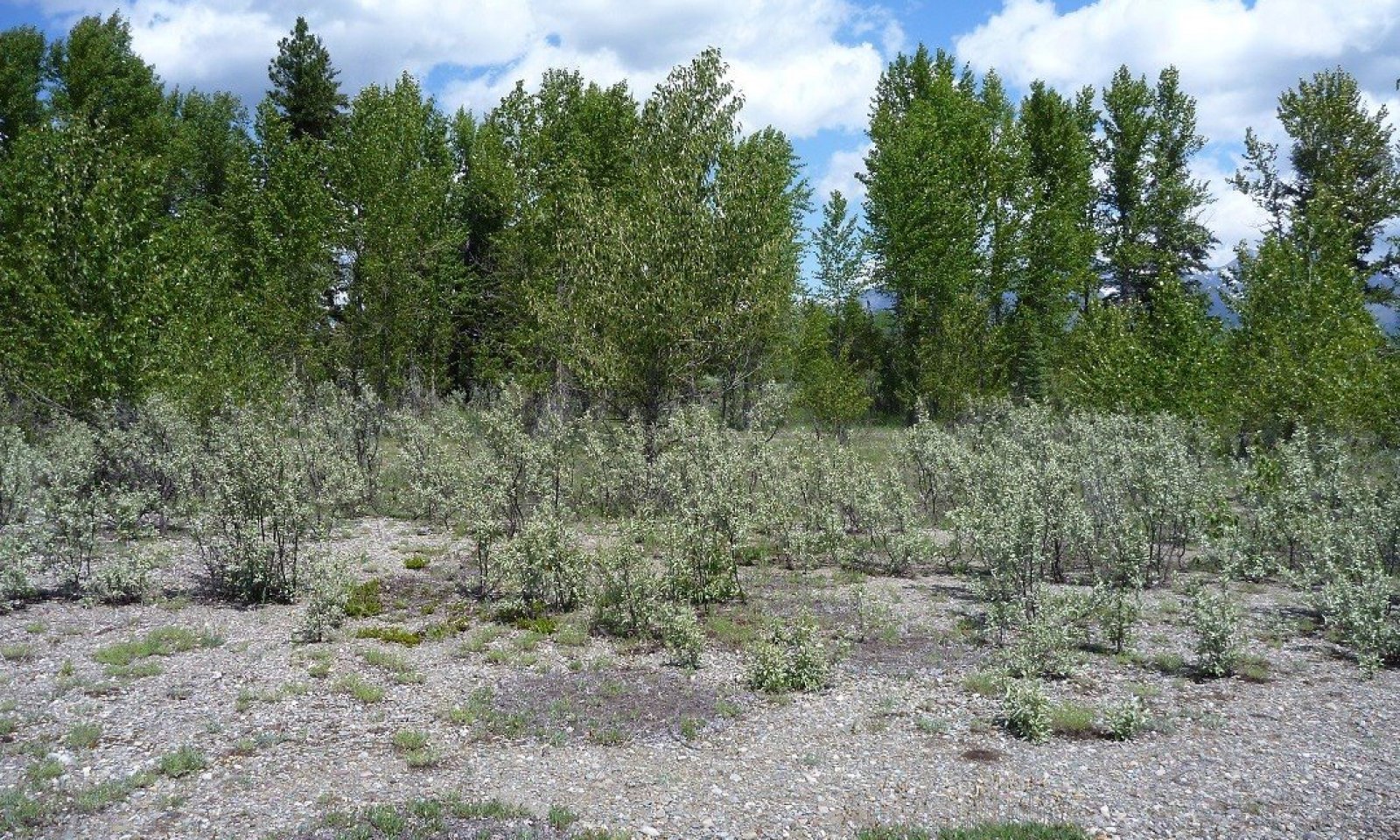
Figure 1. Landscape view of this ecological site on a point bar of a large river
Table 2. Representative physiographic features
Landforms (1) Valley > Flood plain
(2) Valley > Drainageway
Flooding duration Long (7 to 30 days) Flooding frequency Frequent Elevation 3280 – 4265 ft Slope 0 – 15 % Aspect W, NW, N, NE, E, SE, S, SW Climatic features
This ecological site is found in the cryic soil temperature regime and the udic soil moisture regime. Cryic soils have average annual temperature of less than 8 degrees C, with less than 5 degrees C difference from winter to summer. The udic soil moisture regime denotes that the rooting zone is usually moist throughout the winter and the majority of summer. This site is found on the west side of the Continental Divide and has more maritime weather influences.
Climate Summary for West Glacier Station:
Mean Average Precipitation 66-130 cm 26-51 inches
Mean Average Annual Temperature 2-6 degrees C 36-43 degrees F
Frost free days: 50-70
Relative Effective Annual Precipitation: 66-130 cm 26-51 inchesTable 3 Representative climatic features
Frost-free period (characteristic range) 20-60 days Freeze-free period (characteristic range) 80-120 days Precipitation total (characteristic range) 20-30 in Frost-free period (actual range) 10-70 days Freeze-free period (actual range) 70-130 days Precipitation total (actual range) 20-30 in Frost-free period (average) 40 days Freeze-free period (average) 100 days Precipitation total (average) 20 in Characteristic rangeActual rangeBarLineFigure 2. Monthly precipitation range
Characteristic rangeActual rangeBarLineFigure 3. Monthly minimum temperature range
Characteristic rangeActual rangeBarLineFigure 4. Monthly maximum temperature range
BarLineFigure 5. Monthly average minimum and maximum temperature
Figure 6. Annual precipitation pattern
Figure 7 Annual average temperature pattern
Climate stations used
-
(1) POLEBRIDGE 1 N [USC00246618], Essex, MT
-
(2) WEST GLACIER [USC00248809], Kalispell, MT
-
(3) POLEBRIDGE [USC00246615], Essex, MT
">Influencing water features
This site experiences periodic flooding with long duration through the months of April through July. The water table can be at the surface during the months of April through June. There is no ponding at this ecological site. The Cowardin wetland classification system is used to describe wetlands and deepwater habitats. The classification of this ecological site follows:<br />
Cowardin Classification: Paustrine: Class=forested wetland; subclass=broad-leaved deciduous; Water regime= temporarily flooded to intermittently flooded.Wetland description
Cowardin Classification: Paustrine: Class=forested wetland; subclass=broad-leaved deciduous; Water regime= temporarily flooded to intermittently flooded.
Soil features
Soils at these sites typically have a cap of gravelly or sandy soil over river gravel or cobble-sized rocks. Many of these soils classify in the Entisols soil order, indicating that they are young soils formed in recently deposited materials. More specifically, these Entisols are classified as Oxyaquic Cryofluvents. The Oxyaquic subgroup means that they have a water table between 50 to 100 cm from the soil surface. Soils of the Inceptisols and Mollisols soil orders can occur in older more stable sites that are higher relative to the current floodplain and have had a longer time since disturbance. Surface textures are very gravelly coarse sandy loam with a sandy-skeletal particle size family in the subsurface. Water tables usually drop below 1 meter of the soil surface in summer but the soils typically remain moist due to capillary action. This site has rapid movement of highly aerated groundwater through the coarse textured soils and substrates and high volume of coarse fragments throughout the profile. The diagnostic feature of this soil is an ochric epipedon and redoximorphic features due to a fluctuating water table. Some profiles have a very thin surface organic matter layer ranging 1.5-2.5 cm thick. (Soil Survey Staff, 2015). For more information on soil taxonomy, please follow this link:
http://http://www.nrcs.usda.gov/wps/portal/nrcs/detail/soils/survey/class/?cid=nrcs142p2_053580Table 4. Representative soil features
Parent material (1) Alluvium – metasedimentary rock
Surface texture (1) Very gravelly coarse sandy loam
Family particle size (1) Sandy-skeletal
Drainage class Very poorly drained Permeability class Rapid Soil depth 60 – 100 in Available water capacity
(0.6-1.5in)Not specified Soil reaction (1:1 water)
(5.3-6.9in)Not specified Ecological dynamics
This ecological site is found in proximity to large rivers, which are slightly entrenched with moderate to high width to depth ratios, moderate to high sinuosity and have gravel or cobble channel material (Rosgen C4 type). The valleys in which they are found are considered Alluvial (type 8) and are mature, wide, gentle valley slopes with well-developed flood plain features adjacent to river terraces and/or glacial terraces-alluvial valley fills (Rosgen, 1994). Alluvial terraces and flood plains are the predominate landforms. The vegetation community is dominated in the overstory by Black cottonwood with some paper birch. There is little encroachment by conifer species and total cover is less than 5%. The understory has moderate to high shrub cover composed of redosier dogwood, common snowberry and Rocky mountain maple. A diverse assemblage of herbaceous forbs are present in low canopy cover at this ecological site.
This ecological site is found on the north and middle forks of the Flathead River, off Ole Creek and off creeks that feed into McDonald Creek. The Flathead River system exhibits disequilibrium sediment conditions and large amounts of woody debris (Malanson, 1991). There was severe flooding on all forks of this river in 1964, 1975 and 1989 that introduced massive amounts of new woody debris to the system, mobilized large amounts of sediment and created extensive new gravel bars (Malanson, 1991). These gravel bars would, with time without flooding, become vegetated through succession with herbaceous, willow and cottonwood seedlings. Other major floods on the Flathead River were in 1894, 1899, 1948, and 1954. Malanson (1991) conducted a study on correlations of species abundance with environmental variables on the North Fork of the Flathead River. Black cottonwood was found to occupy the most ecologically developed sites of gravel point bars. Factors that Black cottonwood presence were correlated with include soil organic matter and depth, woody debris, distance to head of bar, the size and location of each bar and its species richness. Salix species were correlated with less ecologically developed sites and correlated to elevation of stand, distance from the stand to the head of the bar, the amount of woody debris upstream, clast size, depth of fine sediment and species richness.
Walton (unpublished report, 2006) studied the floodplains of the Nyack floodplain on the Middle Fork of the Flathead River examining the relationships between riparian tree diversity, above ground biomass, stand age, and elevation. Their results indicate that the oldest stands on the Nyack floodplain are approximately 130 years old. The last major flood on the Nyack was in 1894, followed by several slightly less severe floods in 1916, 1964 and 1975. Cottonwoods had the most biomass in stands under approximately 110 years old, then Engelmann spruce dominates the biomass. In terms of individual stems, conifers which establish after 40 years, will dominate after approximately 55 years. The intermediate age stands of 40 years had the highest riparian tree diversity. Scouring frequency is strongly correlated to elevation above channel, with both biomass and stand age increasing linearly with elevation. Succession proceeds as follows: young stands (less than 35 years old) have higher total stem counts and are dominated by cottonwoods then willows. The taller cottonwood trees will shade out the shorter shrubby willow trees and eventually outcompete them. Alder, fir, larch and birch can briefly colonize the stands, but do not get large or live long due to competition. These stands have relatively low diversity. Cottonwoods are not shade tolerant and are great pioneer species. Older stands contain cottonwoods with Engelmann spruce, Grand fir and Douglas fir establishing and dominating after approximately 50 years. Engelmann spruce and fir are relatively shade tolerant conifers and can occupy the forest understory. The cottonwoods that do survive are large, greater than 50cm in DBH. As the stand matures, all size classes are represented and the youngest trees are dominated by Engelmann spruce. The oldest stands measured had only a few cottonwoods, while Engelmann spruce filled the largest DBH classes.
Due to the re-occurring potential of flooding for this ecological site, time for succession to conifers over a much longer time is limited. Therefore, this site is defined by the dominance of black cottonwood with little understory of conifers and is addressing a shorter timeframe of approximately 100 years. Potentially without flooding disturbance, this site could progress to one dominated by conifers, but we are defining this site as precluding that scenario and maintained by flooding disturbance.
The historic fire regime of black cottonwood within the larger vegetation community of Engelmann spruce-subalpine fir is 35 to >200 years (USFS, FEIS, Fire return interval table within black cottonwood species review webpage). This site is susceptible to fire during the late summer and fall. Black cottonwood and associated shrubs resprout after fire and are adapted to light and in some instances moderate intensity fires. Black cottonwood has moderate sprouting capability. Younger trees are more capable of sprouting than old, decadent ones. The higher the water table throughout the growing season, the greater the ability for sprouts to survive. So, timing of fire is important to resprouting capability. Community phase 1.2 is particularly damaged by fire because the cottonwood saplings do not have an extensive root system or thick bark. Numerous research projects throughout the West, have found cottonwood stands in decline. Braatne et. al (1996)attributed this decline to livestock grazing via consumption and trampling of seedlings, water diversion via drought stress, domestic settlement via clearing for development, exotic plants such as saltcedar and Russian-olive reducing recruitment, stream reservoirs, channelization which reduces meandering, agricultural clearing, gravel mining, direct harvesting and unnaturally high populations of beavers.
The montane deciduous alluvium floodplain ecological site is important to wildlife for cover, shade and food for a variety of species. Large mammals use this site depending on the season. The black cottonwood canopy provides nesting sites for bald eagles and ospreys and great blue herons and later Canada geese. Woodpeckers, great horned owls, wood ducks and raccoons nest in trunk cavities. Black cottonwood and red-osier dogwood are eaten by moose and used by beaver for food and building materials (Hansen, 1995). Waterfowl, small birds and mammals use the understory species for food and cover. This site is very important in providing thermal cover, debris recruitment, and streambank stability. Redosier dogwood and other shrub species are excellent in controlling erosion along streams (Hansen, 1995).
Black cottonwood is a fast growing native deciduous tree that lives 100-200 years (USFS FEIS). It has shallow spreading roots with well-developed laterals and are typically ectomycorrhizal. Establishment is by wind or water dispersed seed and establishment is episodic often creating multi-aged stands. Seeds are copious and produced yearly though need both moisture and mineral soil for establishment which occurs in 5-10 year intervals. Seedlings are able to withstand inundation and sediment deposition, which removes competitors. In fact, it requires water with dissolved oxygen content and is very shade intolerant. Ice jams during spring thaw and break up can scour away seedlings and fire will kill them as well as saplings. Black cottonwood trees are frequently damaged by fire even of low severity. Severe fire kills or top kills older trees which may be more resistant to lower severity fires by their thick bark. It sprouts post fire and is considered a fire “endurer”. Fire increases light to the forest floor and exposes mineral soil which cottonwoods need for seedling establishment, therefore it can also be a fire “invader”. Scott et. al (1996) summarized geomorphic processes that influence the type of cottonwood stand to be established. The montane deciduous alluvium floodplain site falls in the meandering fluvial process with frequent moderate flows on point bars that produce moderate numbers of even-aged stands, arranged in narrow, arcuate bands. These have a strong left-bank, right-bank asymmetry in ages based on meander pattern. Often there is directional flood training of stems.
Black cottonwood is categorized as a facultative wetland (FACW) species in the wetland indicator status system (species that usually occur in wetlands (67-99% estimated probability), but is occasionally found in non-wetlands), with medium energy value (retains usable energy value moderately well during fall and winter) and protein value (retains digestible protein value moderately well during fall and winter). It rates poor for cattle and horse forage (not relished and normally consumed to only a small degree or not at all) and fair for sheep (moderately relished and consumed to a moderate degree). For wildlife such as elk, mule deer, whitetail deer and antelope it is rated poor food value (available but the plant is consumed to only a small degree or not at all). It is rated good food value for upland game birds, small non-game birds and small mammals, but fair for waterfowl. It is good whitetail deer cover and small non-game birds and small mammals (readily utilized for cover when available), but fair for elk and mule deer and upland game bird and waterfowl (moderately utilized for cover when available).
Redosier dogwood is a FACW species, with medium energy value and Low protein value (poor retention of digestible protein value during fall and winter). It is fair for cattle and sheep forage palatability, but poor for horses. It is rate good food value for mule and whitetail deer (readily to moderately available in the plant’s range and consumed to a high degree). It is fair for antelope and poor for elk (readily to moderately available in the plant’s range but consumed only to a moderate degree). It is fair food value for upland game birds, waterfowl, small non-game birds and small mammals. It is fair cover value for elk, mule deer, whitetail deer, upland game bird, waterfowl, small non-game bird and small mammals.
Common snowberry is a FACU (species that usually occur in non-wetlands, but occasionally found in wetlands), has medium energy value and medium protein value. It is fair forage palatability for cattle and sheep, but poor for horses. It is considered fair in food value for elk, mule deer, whitetail deer and antelope. It is fair food value for upland game birds, waterfowl, small non-game birds and small mammals. It is fair cover value for mule and whitetail deer, but poor for elk (rarely or never utilized for cover when available). It is good cover for upland game birds, waterfowl, small non-game birds and small mammals.
Rocky Mountain maple is a FAC species (species equally likely to occur in wetlands or non-wetlands), with medium energy value and low protein value. It is fair for sheep forage palatability and poor for cattle and horses. It is rated good food value for mule deer, fair to elk and whitetail deer and poor for antelope. It is fair food value for upland game birds, small non-game birds and small mammals, but poor for waterfowl. It is fair cover value for elk, mule, whitetail deer, upland game birds, waterfowl, small non-game birds and small mammals.
Western meadowrue is a FACU species with low energy and low protein value. It is fair forage palatability for sheep, but poor for cattle and horses. It is considered fair food value for elk, mule and whitetail deer and poor for antelope.
State 1.0: This represents the historic state in which there are no weedy species present at the site. The community is the same composition as currently but without any weedy species.
Community Phase 1.1: This represents mature black cottonwood in the overstory with a significant presence of shorter statured paper birch present. The understory is multistoried with medium statured shrubs common snowberry and redosier dogwood and the low statured shrub thimbleberry and a diverse herbaceous layer with western sweet cicely and western meadowrue. Cowardin Classification: Paustrine: Class=forested wetland; subclass=broad-leaved deciduous; Water regime= temporarily flooded to intermittently flooded.
State 2.0: This represents the current reference state in which the same dominant species exist as in State 1.0 but there is a low presence of weedy species.
Community Phase 2.1: This represents the reference state in which tall, mature black cottonwood dominate the overstory with a minor amount of paper birch. The understory has a mixture of shrubs including: redosier dogwood (Cornus sericea ssp. sericea), common snowberry (Symphoricarpos albus), and Rocky mountain maple (Acer glabrum). There is a mixture of herbaceous forbs. There can be small gap dynamics in which one or two trees die, opening the canopy and allowing sunlight into the forest floor. Cowardin Classification: Paustrine: Class=forested wetland; subclass=broad-leaved deciduous; Water regime= temporarily flooded to intermittently flooded.
Community Phase 2.2: This represents the community post disturbance from flooding or fire. It represents an early seral stage. If the flooding event or fire is substantial, than the site will not have trees. The mineral soil will allow for re-establishment by herbaceous forbs, grasses and resprouting shrubs. Tree species, especially black cottonwood, will become established on the mineral soil. Over time, the trees will over-top the shrubs and herbaceous species, and dominate. This phase is very susceptible to flooding and may be eliminated after just a year or two of growth. Ice can also damage this phase by mechanical damage (bending, shearing or pulling out of young stems or tilting or pushing over of mature trees) or flooding. Seedlings and sapling black cottonwoods are particularly susceptible to fire since their bark is thin and the root system shallow. Young black 0cottonwoods are very susceptible to defoliation by livestock, wildlife and beaver use, and can be eliminated. Cowardin: System=palustrine; Class=forested wetland; Subclass=broad-leaved deciduous; Water Regime (nontidal) = seasonally flooded.
Community Phase 2.3: This represents the community in competitive exclusion phase in which the tree seedlings have grown to sapling and pole sized trees and are competing with each other for resources. The canopy cover is very high, shading out the forest floor and limiting the understory to shade-tolerant species. Cowardin Classification: Paustrine: Class=forested wetland; subclass=broad-leaved deciduous; Water regime= temporarily flooded to intermittently flooded.
State 3.0 Native with introduced annuals state:
3.1: This represents the community after heavy grazing resulting in a decrease of shrubs species except western snowberry and rose species and an introduction of weedy species such as timothy and Kentucky bluegrass. This represents a moderately disturbed secondary successional stage. Cowardin Classification: Paustrine: Class=forested wetland; subclass=broad-leaved deciduous; Water regime= temporarily flooded to intermittently flooded.
3.2: This represents the community after severe grazing in which all shrub species have been eliminated and the cover of weedy species has increased dramatically. Secondary successional state. This depauperate state has only an overstory of black cottonwood and an understory of wood’s rose, common timothy and Kentucky bluegrass. Cowardin Classification: Paustrine: Class=forested wetland; subclass=broad-leaved deciduous; Water regime= temporarily flooded to intermittently flooded.
Community Phase Pathway 2.1.A: This pathway represents flooding disturbance intense enough to kill trees and set the site back to mineral soil and colonizing herbaceous species, resprouting shrubs and tree seedlings.
Community Phase Pathway 2.2A: This pathway represents time without disturbance.
Community Phase Pathway 2.3A: This pathway represents time without disturbance.
Community Phase Pathway 2.3B: This pathway represents flooding disturbance intense enough to kill trees and set the site back to mineral soil and colonizing herbaceous species, resrouting shrubs and tree seedlings.
Transition 1: This represents the pathway from the historic state 1.0 without any weedy species present in the vegetation community to State 2.0 in which there are very low covers of weedy species present in the vegetation community.
Transition 2: This represents the pathway from State 2.0 the current reference state in which the cover of weedy species is very low to State 3.0 in which there has been a dramatic increase of weedy species through heavy continuous livestock grazing.
Community Phase Pathway 3.1.A: This pathway represents the community after heavy grazing with a concomitant loss of shrub species except western snowberry and rose species.
Community Phase Pathway 3.2A: This pathway represents the community after cessation heavy grazing or establishment of prescribed grazing methods in which there is an increase of shrub species such as serviceberry, redosier dogwood and western snowberry and a decrease in shrub species such as western snowberry and rose species.State and transition model
More interactive model formats are also available. View Interactive Models
Click on state and transition labels to scroll to the respective textEcosystem states
State 1 submodel, plant communities
State 2 submodel, plant communities
State 1
Historic ReferenceThis represents the historic state in which there are no weedy species present at the site. The community is the same composition as currently but without any weedy species.
Community 1.1
Black cottonwood-aspen/redosier dogwood-snowberry/thimbleberry/western meadow-rue-western sweetrootThis represents mature black cottonwood in the overstory with a significant presence of shorter statured paper birch present. The understory is multistoried with medium statured shrubs common snowberry and redosier dogwood and the low statured shrub thimbleberry and a diverse herbaceous layer with western sweet cicely and western meadowrue. Cowardin Classification: Paustrine: Class=forested wetland; subclass=broad-leaved deciduous; Water regime= temporarily flooded to intermittently flooded.
The vegetation community is dominated in the overstory by Black cottonwood with some paper birch. There is little encroachment by conifer species and total cover is less than 5%. The understory has moderate to high shrub cover composed of redosier dogwood, common snowberry and Rocky mountain maple. A diverse assemblage of herbaceous forbs are present in low canopy cover at this ecological site.
This ecological site is found on the north and middle forks of the Flathead River, off Ole Creek and off creeks that feed into McDonald Creek. The Flathead River system exhibits disequilibrium sediment conditions and large amounts of woody debris (Malanson, 1991). There was severe flooding on all forks of this river in 1964, 1975 and 1989 that introduced massive amounts of new woody debris to the system, mobilized large amounts of sediment and created extensive new gravel bars (Malanson, 1991). These gravel bars would, with time without flooding, become vegetated through succession with herbaceous, willow and cottonwood seedlings. Other major floods on the Flathead River were in 1894, 1899, 1948, and 1954. Malanson (1991) conducted a study on correlations of species abundance with environmental variables on the North Fork of the Flathead River. Black cottonwood was found to occupy the most ecologically developed sites of gravel point bars. Factors that Black cottonwood presence were correlated with include soil organic matter and depth, woody debris, distance to head of bar, the size and location of each bar and its species richness. Salix species were correlated with less ecologically developed sites and correlated to elevation of stand, distance from the stand to the head of the bar, the amount of woody debris upstream, clast size, depth of fine sediment and species richness.
Walton (unpublished report, 2006) studied the floodplains of the Nyack floodplain on the Middle Fork of the Flathead River examining the relationships between riparian tree diversity, above ground biomass, stand age, and elevation. Their results indicate that the oldest stands on the Nyack floodplain are approximately 130 years old. The last major flood on the Nyack was in 1894, followed by several slightly less severe floods in 1916, 1964 and 1975. Cottonwoods had the most biomass in stands under approximately 110 years old, then Engelmann spruce dominates the biomass. In terms of individual stems, conifers which establish after 40 years, will dominate after approximately 55 years. The intermediate age stands of 40 years had the highest riparian tree diversity. Scouring frequency is strongly correlated to elevation above channel, with both biomass and stand age increasing linearly with elevation. Succession proceeds as follows: young stands (less than 35 years old) have higher total stem counts and are dominated by cottonwoods then willows. The taller cottonwood trees will shade out the shorter shrubby willow trees and eventually outcompete them. Alder, fir, larch and birch can briefly colonize the stands, but do not get large or live long due to competition. These stands have relatively low diversity. Cottonwoods are not shade tolerant and are great pioneer species. Older stands contain cottonwoods with Engelmann spruce, Grand fir and Douglas fir establishing and dominating after approximately 50 years. Engelmann spruce and fir are relatively shade tolerant conifers and can occupy the forest understory. The cottonwoods that do survive are large, greater than 50cm in DBH. As the stand matures, all size classes are represented and the youngest trees are dominated by Engelmann spruce. The oldest stands measured had only a few cottonwoods, while Engelmann spruce filled the largest DBH classes.
Due to the re-occurring potential of flooding for this ecological site, time for succession to conifers over a much longer time is limited. Therefore, this site is defined by the dominance of black cottonwood with little understory of conifers and is addressing a shorter timeframe of approximately 100 years. Potentially without flooding disturbance, this site could progress to one dominated by conifers, but we are defining this site as precluding that scenario and maintained by flooding disturbance.
The historic fire regime of black cottonwood within the larger vegetation community of Engelmann spruce-subalpine fir is 35 to >200 years (USFS, FEIS, Fire return interval table within black cottonwood species review webpage). This site is susceptible to fire during the late summer and fall. Black cottonwood and associated shrubs resprout after fire and are adapted to light and in some instances moderate intensity fires. Black cottonwood has moderate sprouting capability. Younger trees are more capable of sprouting than old, decadent ones. The higher the water table throughout the growing season, the greater the ability for sprouts to survive. So, timing of fire is important to resprouting capability.State 2
Current PotentialThis represents the current reference state in which the same dominant species exist as in State 1.0 but there is a low presence of weedy species.
Community 2.1
Black cottonwood-aspen/redosier dogwood-snowberry/thimbleberry/western meadow-rue-western sweetroot. Time: 80+ years
Figure 8. View of community phase 2.1 of this ecological site.

Figure 9. View of the overstory of Black cottonwood trees and understory of the mat-forming yellow mountain avens (Dryas drummondii).
This represents the reference state in which tall, mature black cottonwood dominate the overstory with a minor amount of paper birch. The understory has a mixture of shrubs including: redosier dogwood (Cornus sericea ssp. sericea), common snowberry (Symphoricarpos albus), and Rocky mountain maple (Acer glabrum). There is a mixture of herbaceous forbs. There can be small gap dynamics in which one or two trees die, opening the canopy and allowing sunlight into the forest floor. Cowardin Classification: Paustrine: Class=forested wetland; subclass=broad-leaved deciduous; Water regime= temporarily flooded to intermittently flooded.
Forest overstory.The forest overstory is composed of black cottonwood and a subcanopy of quaking aspen.
Forest understory. The understory is composed of a mixture of multi-storied shrub layers and a lower very diverse herbaceous layer.
Dominant plant species
-
black cottonwood (Populus balsamifera ssp. trichocarpa), tree
-
redosier dogwood (Cornus sericea ssp. sericea), shrub
-
common snowberry (Symphoricarpos albus), shrub
-
thimbleberry (Rubus parviflorus), shrub
-
western meadow-rue (Thalictrum occidentale), other herbaceous
-
sweetcicely (Osmorhiza berteroi), other herbaceous
Figure 10. Annual production by plant type (representative values) or group (midpoint values)
Community 2.2
Seedlings, shrubs and forbs establish post disturbance phaseThis represents the community post disturbance from flooding or fire. It represents an early seral stage. If the flooding event or fire is substantial, than the site will not have trees. The mineral soil will allow for re-establishment by herbaceous forbs, grasses and resprouting shrubs. Tree species, especially black cottonwood, will become established on the mineral soil. Over time, the trees will over-top the shrubs and herbaceous species, and dominate. This phase is very susceptible to flooding and may be eliminated after just a year or two of growth. Ice can also damage this phase by mechanical damage (bending, shearing or pulling out of young stems or tilting or pushing over of mature trees) or flooding. Seedlings and sapling black cottonwoods are particularly susceptible to fire since their bark is thin and the root system shallow. Young black cottonwoods are very susceptible to defoliation by livestock, wildlife and beaver use, and can be eliminated. Cowardin: System=palustrine; Class=forested wetland; Subclass=broad-leaved deciduous; Water Regime (nontidal) = seasonally flooded.
Community 2.3
Black cottonwood-paper birch. Competitive exclusion phase of thick pole sized trees. Time: 30-80 yearsThis represents the community in competitive exclusion phase in which the tree seedlings have grown to sapling and pole sized trees and are competing with each other for resources. The canopy cover is very high, shading out the forest floor and limiting the understory to shade-tolerant species. Cowardin Classification: Palustrine: Class=forested wetland; subclass=broad-leaved deciduous; Water regime= temporarily flooded to intermittently flooded.
Pathway 2.1A
Community 2.1 to 2.2This pathway represents flooding disturbance intense enough to kill trees and set the site back to mineral soil and colonizing herbaceous species, resprouting shrubs and tree seedlings.
Pathway 2.2A
Community 2.2 to 2.3This pathway represents time without disturbance.
Pathway 2.3A
Community 2.3 to 2.1This pathway represents time without disturbance.
Pathway 2.3B
Community 2.3 to 2.2This pathway represents flooding disturbance intense enough to kill trees and set the site back to mineral soil and colonizing herbaceous species, resprouting shrubs and tree seedlings.
State 3
InvadedCommunity 3.1
Riparian forest with non-native herbceous and increased snowberry and rose.This represents the community after heavy grazing resulting in a decrease of shrubs species except western snowberry and rose species and an introduction of weedy species such as timothy and Kentucky bluegrass. This represents a moderately disturbed secondary successional stage. The foliar cover is only moderate at this phase. Data taken at two sites show foliar cover is 32%, bare ground is 15% and basal cover is 3%. Total litter, which includes woody litter and litter, is 58%. Soil surface is soil (74%), visible lichen (13%) and gravel (4%). Cowardin Classification: Palustrine: Class=forested wetland; subclass=broad-leaved deciduous; Water regime= temporarily flooded to intermittently flooded
Community 3.2
Riparian forest with non-native herbaceous and loss of shrub species.This represents the community after severe grazing in which all shrub species have been eliminated and the cover of weedy species has increased dramatically. Secondary successional state. This depauperate state has only an overstory of black cottonwood and an understory of wood’s rose, common timothy and Kentucky bluegrass. Cowardin Classification: Palustrine: Class=forested wetland; subclass=broad-leaved deciduous; Water regime= temporarily flooded to intermittently flooded.
Pathway 3.1A
Community 3.1 to 3.2This pathway represents the community after heavy grazing with a concomitant loss of shrub species except western snowberry and rose species.
Pathway 3.2A
Community 3.2 to 3.1This pathway represents the community after cessation heavy grazing or establishment of prescribed grazing methods in which there is an increase of shrub species such as serviceberry, redosier dogwood and western snowberry and a decrease in shrub species such as western snowberry and rose species.
Transition T1A
State 1 to 2This represents the pathway from the historic state 1.0 without any weedy species present in the vegetation community to State 2.0 in which there are very low covers of weedy species present in the vegetation community.
Transition T2A
State 2 to 3This represents the pathway from State 2.0 the current reference state in which the cover of weedy species is very low to State 3.0 in which there has been a dramatic increase of weedy species through heavy continuous livestock grazing.
Additional community tables
Table 5. Community 1.1 plant community composition
Group Common name Symbol Scientific name Annual production () Foliar cover (%) Table 6. Community 2.1 plant community composition
Group Common name Symbol Scientific name Annual production () Foliar cover (%) Forb1 Perennial and annual forbs – knapweed CENTA Centaurea – 0–5 blanketflower GAAR Gaillardia aristata – 0–5 sweetclover MEOF Melilotus officinalis – 0–5 common selfheal PRVU Prunella vulgaris – 0–5 clover TRIFO Trifolium – 0–5 milkvetch ASTRA Astragalus – 0–5 Grass/Grasslike2 Grasses and rushes – horsetail EQUIS Equisetum – 0–5 Kentucky bluegrass POPR Poa pratensis – 0–5 Shrub/Vine3 Shrubs and subshrubs – Drummond's mountain-avens DRDR Dryas drummondii – 0–25 creeping barberry MARE11 Mahonia repens – 0–5 redosier dogwood COSES Cornus sericea ssp. sericea – 0–5 Table 7. Community 2.1 forest overstory composition
Common name Symbol Scientific name Nativity Height ft Canopy cover (%) Diameter in Basal area (square ft/acre) Treeblack cottonwood POBAT Populus balsamifera ssp. trichocarpa Native 30-120 20-40 – 0 quaking aspen POTR5 Populus tremuloides Native 10-30 0-20 – 0 Table 8. Community 2.1 forest understory composition
Common name Symbol Scientific name Nativity Height (ft) Canopy cover (%) Grass/grass-like (Graminoids)Kentucky bluegrass POPR Poa pratensis – – 3–20 smooth brome BRIN2 Bromus inermis – – 3 Columbia brome BRVU Bromus vulgaris – – 0.5–3 fringed brome BRCI2 Bromus ciliatus – – 1 Geyer's sedge CAGE2 Carex geyeri – – 0.5–1 blue wildrye ELGL Elymus glaucus – – 0.5–1 bluejoint CACA4 Calamagrostis canadensis – – 0.5 timothy PHPR3 Phleum pratense – – 0.5 fowl bluegrass POPA2 Poa palustris – – 0.5 Forb/Herbwild sarsaparilla ARNU2 Aralia nudicaulis – – 70 Lyall's angelica ANAR3 Angelica arguta – – 0.5–13 smooth blue aster SYLA3 Symphyotrichum laeve – – 0.5–13 drops-of-gold PRHO2 Prosartes hookeri – – 3–10 silverberry ELCO Elaeagnus commutata – – 10 Cascara buckthorn FRPU7 Frangula purshiana – – 10 Virginia strawberry FRVI Fragaria virginiana – – 0.5–4 starry false lily of the valley MAST4 Maianthemum stellatum – – 0.5–4 feathery false lily of the valley MARA7 Maianthemum racemosum – – 0.5–3 common cowparsnip HEMA80 Heracleum maximum – – 0.5–3 bride's bonnet CLUN2 Clintonia uniflora – – 3 tasselflower brickellbush BRGR Brickellia grandiflora – – 3 fireweed CHANA2 Chamerion angustifolium ssp. angustifolium – – 0.5–3 American trailplant ADBI Adenocaulon bicolor – – 0.5–3 Missouri goldenrod SOMI2 Solidago missouriensis – – 3 white clover TRRE3 Trifolium repens – – 3 American vetch VIAM Vicia americana – – 0.5–3 Canadian white violet VICA4 Viola canadensis – – 3 giant goldenrod SOGI Solidago gigantea – – 1 western meadow-rue THOC Thalictrum occidentale – – 0.5–1 western snowberry SYOC Symphoricarpos occidentalis – – 1 common dandelion TAOF Taraxacum officinale – – 0.5–1 cream pea LAOC2 Lathyrus ochroleucus – – 0.5–1 northern bedstraw GABO2 Galium boreale – – 1 threepetal bedstraw GATR2 Galium trifidum – – 1 fragrant bedstraw GATR3 Galium triflorum – – 0.5 largeleaf avens GEMA4 Geum macrophyllum – – 0.5 manyflower stickseed HAFL2 Hackelia floribunda – – 0.5 blanketflower GAAR Gaillardia aristata – – 0.5 western showy aster EUCO36 Eurybia conspicua – – 0.5 oxeye daisy LEVU Leucanthemum vulgare – – 0.5 twinflower LIBO3 Linnaea borealis – – 0.5 white hawkweed HIAL2 Hieracium albiflorum – – 0.5 falsegold groundsel PAPSP2 Packera pseudaurea var. pseudaurea – – 0.5 bracted lousewort PEBR Pedicularis bracteosa – – 0.5 black medick MELU Medicago lupulina – – 0.5 sweetclover MEOF Melilotus officinalis – – 0.5 Smith's melicgrass MESM Melica smithii – – 0.5 Brewer's miterwort MIBR6 Mitella breweri – – 0.5 naked miterwort MINU3 Mitella nuda – – 0.5 bluntleaf sandwort MOLA6 Moehringia lateriflora – – 0.5 sidebells wintergreen ORSE Orthilia secunda – – 0.5 sweetcicely OSBE Osmorhiza berteroi – – 0.5 pale agoseris AGGL Agoseris glauca – – 0.5 nodding onion ALCE2 Allium cernuum – – 0.5 common yarrow ACMI2 Achillea millefolium – – 0.5 anemone ANEMO Anemone – – 0.5 western pearly everlasting ANMA Anaphalis margaritacea – – 0.5 Pacific anemone ANMU Anemone multifida – – 0.5 Chamisso arnica ARCH3 Arnica chamissonis – – 0.5 tower rockcress ARGL Arabis glabra – – 0.5 pipsissewa CHUM Chimaphila umbellata – – 0.5 small enchanter's nightshade CIAL Circaea alpina – – 0.5 Canada thistle CIAR4 Cirsium arvense – – 0.5 white thistle CIHO Cirsium hookerianum – – 0.5 rock clematis CLCO2 Clematis columbiana – – 0.5 summer coralroot COMA25 Corallorhiza maculata – – 0.5 gypsyflower CYOF Cynoglossum officinale – – 0.5 western tansymustard DEPI Descurainia pinnata – – 0.5 bigflower tellima TEGR2 Tellima grandiflora – – 0.5 lambstongue ragwort SEIN2 Senecio integerrimus – – 0.5 alpine leafybract aster SYFO2 Symphyotrichum foliaceum – – 0.5 stinging nettle URDI Urtica dioica – – 0.5 threeleaf foamflower TITR Tiarella trifoliata – – 0.5 red clover TRPR2 Trifolium pratense – – 0.5 common selfheal PRVU Prunella vulgaris – – 0.5 Maryland sanicle SAMA2 Sanicula marilandica – – 0.5 pioneer violet VIGL Viola glabella – – 0.5 violet VIOLA Viola – – 0.5 darkwoods violet VIOR Viola orbiculata – – 0.5 Fern/fern allywestern brackenfern PTAQ Pteridium aquilinum – – 10 common ladyfern ATFI Athyrium filix-femina – – 3 northern hollyfern POLO4 Polystichum lonchitis – – 0.5–3 ladyfern ATHYR Athyrium – – 0.5 Aleutian maidenhair ADAL Adiantum aleuticum – – 0.5 field horsetail EQAR Equisetum arvense – – 0.5 water horsetail EQFL Equisetum fluviatile – – 0.5 Shrub/Subshrubcommon snowberry SYAL Symphoricarpos albus – – 3–73 black hawthorn CRDO2 Crataegus douglasii – – 20–60 redosier dogwood COSES Cornus sericea ssp. sericea – – 2–50 Woods' rose ROWO Rosa woodsii – – 0.5–20 russet buffaloberry SHCA Shepherdia canadensis – – 4–10 Sitka alder ALVIS Alnus viridis ssp. sinuata – – 0.5–10 Oregon boxleaf PAMY Paxistima myrsinites – – 0.5–10 dwarf rose ROGY Rosa gymnocarpa – – 3–4 Scouler's willow SASC Salix scouleriana – – 0.5–3 thimbleberry RUPA Rubus parviflorus – – 0.5–3 Bebb willow SABE2 Salix bebbiana – – 3 prickly currant RILA Ribes lacustre – – 3 Saskatoon serviceberry AMAL2 Amelanchier alnifolia – – 0.5–3 creeping barberry MARE11 Mahonia repens – – 0.5–2 common juniper JUCO6 Juniperus communis – – 2 kinnikinnick ARUV Arctostaphylos uva-ursi – – 1 red baneberry ACRU2 Actaea rubra – – 0.5 Rocky Mountain juniper JUSC2 Juniperus scopulorum – – 0.5 twinberry honeysuckle LOIN5 Lonicera involucrata – – 0.5 Engelmann's aster EUEN Eucephalus engelmannii – – 0.5 prickly rose ROAC Rosa acicularis – – 0.5 chokecherry PRVI Prunus virginiana – – 0.5 alderleaf buckthorn RHAL Rhamnus alnifolia – – 0.5 whitestem gooseberry RIIN2 Ribes inerme – – 0.5 willow SALIX Salix – – 0.5 American red raspberry RUID Rubus idaeus – – 0.5 red elderberry SARA2 Sambucus racemosa – – 0.5 TreeRocky Mountain maple ACGL Acer glabrum – – 0.5–40 paper birch BEPA Betula papyrifera – – 0.5–30 western redcedar THPL Thuja plicata – 0–39 0.5–3 Table 9. Community 2.2 plant community composition
Group Common name Symbol Scientific name Annual production () Foliar cover (%) Table 10. Community 2.3 plant community composition
Group Common name Symbol Scientific name Annual production () Foliar cover (%) Table 11. Community 3.1 plant community composition
Group Common name Symbol Scientific name Annual production () Foliar cover (%) Table 12. Community 3.2 plant community composition
Group Common name Symbol Scientific name Annual production () Foliar cover (%) Interpretations
Supporting information
Other references
References
Braatne, Jeffrey H.; Rood, Stewart B.; Heilman, Paul E. 1996. Life history, ecology, and conservation of riparian cottonwoods in North America. In: Steller, R. F., ed. Biology of Populus and its implications for management and conservation. Ottawa, ON: National Research Council of Canada, NRC Research Press: 57-85.
Hansen, Paul L.; Pfister, Robert D.; Boggs, Keith; [and others]. 1995. Classification and management of Montana's riparian and wetland sites. Miscellaneous Publication No. 54. Missoula, MT: The University of Montana, School of Forestry, Montana Forest and Conservation Experiment Station. 646 p.
Malanson, George P.; Butler, David R. 1991. Floristic variation among gravel bars in a subalpine river, Montana, U.S.A. Arctic and Alpine Research. 23(3): 273-278.
Lesica, P. and S. Miles. 1998. Can. J. Bot. 77: 1077–1083 (1999).
Pearce, C. and D. Smith. 2003. Wetlands Vol. 23 No.2. 14-22.
Nagler, Pamela L., Edward P. Glenn, Catherine S. Jarnevich & Patrick B. Shafroth (2011) Distribution and Abundance of Saltcedar and Russian Olive in the Western United States, Critical Reviews in Plant Sciences, 30:6, 508-523.
NatureServe, 2007. U.S. National Vegetation Classification Standard: Terrestrial Ecological Classifications. Waterton-Glacier International Peace Park, Local and Global Association Descriptions.
Rosgen, David L. "A classification of natural rivers." Catena 22.3 (1994): 169-199.
Scott, Michael, Jonathan Friedman, Gergor Auble. 1996. Fluvial process and the establishment of bottomland trees.
Geomorphology 14 (1996) pp. 327-339.
Soil Survey Staff. 2015. Illustrated guide to soil taxonomy. U.S. Department of Agriculture, Natural Resources Conservation Service, National Soil Survey Center, Lincoln, Nebraska.
Walton, Kelly. 2006. Riparian forest succession and changes in stand diversity and above ground biomass on the Nyack floodplain in northwestern Montana (unpublished report).Approval
Kirt Walstad, 4/07/2025
Rangeland health reference sheet
Interpreting Indicators of Rangeland Health is a qualitative assessment protocol used to determine ecosystem condition based on benchmark characteristics described in the Reference Sheet. A suite of 17 (or more) indicators are typically considered in an assessment. The ecological site(s) representative of an assessment location must be known prior to applying the protocol and must be verified based on soils and climate. Current plant community cannot be used to identify the ecological site.
Author(s)/participant(s) Contact for lead author Date 12/18/2020 Approved by Approval date Composition (Indicators 10 and 12) based on Annual Production Indicators
-
Number and extent of rills:
-
Presence of water flow patterns:
-
Number and height of erosional pedestals or terracettes:
-
Bare ground from Ecological Site Description or other studies (rock, litter, lichen, moss, plant canopy are not bare ground):
-
Number of gullies and erosion associated with gullies:
-
Extent of wind scoured, blowouts and/or depositional areas:
-
Amount of litter movement (describe size and distance expected to travel):
-
Soil surface (top few mm) resistance to erosion (stability values are averages - most sites will show a range of values):
-
Soil surface structure and SOM content (include type of structure and A-horizon color and thickness):
-
Effect of community phase composition (relative proportion of different functional groups) and spatial distribution on infiltration and runoff:
-
Presence and thickness of compaction layer (usually none; describe soil profile features which may be mistaken for compaction on this site):
-
Functional/Structural Groups (list in order of descending dominance by above-ground annual-production or live foliar cover using symbols: >>, >, = to indicate much greater than, greater than, and equal to):
Dominant:
Sub-dominant:
Other:
Additional:
-
Amount of plant mortality and decadence (include which functional groups are expected to show mortality or decadence):
-
Average percent litter cover (%) and depth ( in):
-
Expected annual annual-production (this is TOTAL above-ground annual-production, not just forage annual-production):
-
Potential invasive (including noxious) species (native and non-native). List species which BOTH characterize degraded states and have the potential to become a dominant or co-dominant species on the ecological site if their future establishment and growth is not actively controlled by management interventions. Species that become dominant for only one to several years (e.g., short-term response to drought or wildfire) are not invasive plants. Note that unlike other indicators, we are describing what is NOT expected in the reference state for the ecological site:
-
Perennial plant reproductive capability:
Print Options
Sections
Font
AAAAOther
PrintThe Ecosystem Dynamics Interpretive Tool is an information system framework developed by the USDA-ARS Jornada Experimental Range, USDA Natural Resources Conservation Service, and New Mexico State University.
Accessibility statement