Natural Resources
Conservation Service
Ecological site F043AX954MT
Upper Subalpine Cold Coniferous
subalpine fir (Engelmann spruce) /thinleaf huckleberry-rusty menziesia/
Hitchcock’s smooth woodrush-beargrass/yellow avalanche lily.
Last updated: 3/11/2025
Accessed: 07/15/2026
-
Search


Major Land Resource Area or ecological site by name and/or ID.
PreviousSectionsNextGeneral information
Provisional. A provisional ecological site description has undergone quality control and quality assurance review. It contains a working state and transition model and enough information to identify the ecological site.
MLRA notes
Major Land Resource Area (MLRA): 043A–Northern Rocky Mountains
This MLRA is located in Montana (43 percent), Idaho (34 percent), and Washington (23 percent). It makes up about 31,435 square miles (81,460 square kilometers). It has no large cities or towns. It has many national forests, including the Okanogan, Colville, Kootenai, Lolo, Flathead, Coeur d’Alene, St. Joe, Clearwater, and Kaniksu National Forests.
This MLRA is in the Northern Rocky Mountains Province of the Rocky Mountain System. It is characterized by rugged, glaciated mountains; thrust- and block-faulted mountains; and hills and valleys. Steep-gradient rivers have cut deep canyons. Natural and manmade lakes are common.
The major Hydrologic Unit Areas (identified by four-digit numbers) that make up this MLRA are: Kootenai-Pend Oreille-Spokane (1701), 67 percent; Upper Columbia (1702), 18 percent; and Lower Snake (1706), 15 percent. Numerous rivers originate in or flow through this area, including, the Sanpoil, Columbia, Pend Oreille, Kootenai, St. Joe, Thompson, and Flathead Rivers.
This area is underlain primarily by stacked slabs of layered sedimentary or metasedimentary bedrock. The bedrock formations range from Precambrian to Cretaceous in age. The rocks consist of shale, sandstone, siltstone, limestone, argillite, quartzite, gneiss, schist, dolomite, basalt, and granite. The formations have been faulted and stacked into a series of imbricate slabs by regional tectonic activity. Pleistocene glaciers carved a rugged landscape that includes sculpted hills and narrow valleys filled with till and outwash. Continental glaciation over road the landscape in the northern half of the MLRA while glaciation in the southern half was confined to montane settings.
The average annual precipitation is 25 to 60 inches (635 to 1,525 millimeters) in most of this area, but it is as much as 113 inches (2,870 millimeters) in the mountains and is 10 to 15 inches (255 to 380 millimeters) in the western part of the area. Summers are dry. Most of the precipitation during fall, winter, and spring is snow. The average annual temperature is 32 to 51 degrees F (0 to 11 degrees C) in most of the area, decreasing with elevation. In most of the area, the freeze-free period averages 140 days and ranges from 65 to 215 days. It is longest in the low valleys of Washington, and it decreases in length with elevation. Freezing temperatures occur every month of the year on high mountains, and some peaks have a continuous cover of snow and ice.
The dominant soil orders in this MLRA are Andisols, Inceptisols, and Alfisols. Many of the soils are influenced by Mount Mazama ash deposits. The soils in the area have a frigid or cryic soil temperature regime; have an ustic, xeric, or udic soil moisture regime; and dominantly have mixed mineralogy. They are shallow to very deep, are very poorly drained to well drained, and have most of the soil texture classes. The soils at the lower elevations include Udivitrands, Vitrixerands and Haplustalfs. The soils at the higher elevations include Dystrocryepts, Eutrocryepts, Vitricryands , and Haplocryalfs. Cryorthents, Cryepts, and areas of rock outcrop are on ridges and peaks above timberline
This area is in the northern part of the Northern Rocky Mountains. Grand fir, Douglas-fir, western red cedar, western hemlock, western larch, lodgepole pine, subalpine fir, ponderosa pine, whitebark pine, and western white pine are the dominant overstory species, depending on precipitation, temperature, elevation, and landform aspect. The understory vegetation varies, also depending on climatic and landform factors. Some of the major wildlife species in this area are whitetailed deer, mule deer, elk, moose, black bear, grizzly bear, coyote, fox, and grouse. Fish, mostly in the trout and salmon families, are abundant in streams, rivers, and lakes.
More than one-half of this area is federally owned and administered by the U.S. Department of Agriculture, Forest Service. Much of the privately-owned land is controlled by large commercial timber companies. The forested areas are used for wildlife habitat, recreation, watershed, livestock grazing, and timber production. Meadows provide summer grazing for livestock and big game animals. Less than 3 percent of the area is cropland.LRU notes
This ecological site resides in MLRA 43A in the Livingston-Lewis-Apgar Mountains which includes the bulk of Glacier National Park (GNP) and the lower western valley portions along the Flathead River. The landscape is mountains and landforms include glaciated mountains with associated features such as U-shaped valleys, mountain slopes, alpine ridges, cirques, valley floors and moraines. Glaciation of this area was in the form of alpine, icecaps and valley outlet glaciers. It also includes associated alluvium and outwash features. This area includes low valleys to tall mountains with elevation ranging 989-2,762 m (3,250-9,050 ft.). The climate is cold and wet with mean annual air temperature of 3 degrees Celsius (37 degrees F.), mean frost free days of 65 days and mean annual precipitation of 1295 mm (51 in.) and relative effective annual precipitation is 169 cm (66 in.). The soil temperature regime is cryic and the soil moisture regime is udic. The geology of this area is dominated by metasedimentary rocks of the Belt Supergroup (Grinnell argillite and Siyeh limestone) with minor Tertiary sediments. Soils are generally weakly developed on mountain slopes within U-shaped valleys. Parent materials are commonly of colluvium, till, and residuum from metasedimentary rocks. Limestone bedrock within this part of the Belt Supergroup is not highly calcareous and due to high precipitation received in this area most carbonates at mid and upper elevations have been leached from the soil profiles. Bedrock depth varies greatly with location, landform and slope position. Volcanic ash is often found in the soil surface with various degrees of mixing. Thicker volcanic ash can be found on more stable positions on mid and upper elevation slopes that are protected from wind erosion. Volcanic ash is not typically found in low elevation areas on stream and outwash terraces associated with streams and rivers. There are numerous large lakes including St. Mary, Bowman, Kintla, Lake Sherburne, Logging, Upper Waterton and numerous creeks (
Classification relationships
This ecological site relates to the USFS Habitat Type ABLA/LUGLH. This site relates to the USFS Habitat Type Group 10 and Fire Group 10. Both of these classification guides are specifically for the western Montana and northern Idaho region. It also relates to the National Park Service, NatureServe classification Abies lasiocarpa-Picea engelmannii/Luzula glabrata var. hitchcockii Woodland CEGL000317.
Ecological site concept
The 43A Upper Subalpine Cold Coniferous ecological site is found along the Continental Divide in cold, moist to moderately dry, high elevation sites that span the upper subalpine zone. These sites are above the cold limits of Douglas-fir (Pseudotsuga menziesii), western white pine (Pinus monticola), western larch (Larix occidentalis), with common species including whitebark pine (Pinus albicaulis), lodgepole pine (Pinus contorta), mountain hemlock (Tsuga mertensiana), subalpine fir (Abies lasiocarpa), Engelmann spruce (Picea engelmannii), and subalpine larch (Larix lyallii). Subalpine fir dominates the Reference State with the long-lived seral species whitebark pine and Engelmann spruce. Subalpine fir is tall, usually growing more than 50 feet tall at maturity and is not stunted in the krummholtz form. The understory is not diverse, rather it is composed of only a few important species. Shrubs include rusty menziesia (Menziesia ferruginea), grouse whortleberry (Vaccinium scoparium), pink mountainheath (Phyllodoce empetriformis), and yellow mountainheath (Phyllodoce glanduliflora). There may be high cover of grouse whortleberry and/or Hitchcocks smooth woodrush, which are indicative of cold conditions. Common forbs are broadleaf arnica, beargrass, Rosss sedge, Idaho fescue, Parrys rush, and Hitchcocks smooth woodrush. The soils associated with this ecological site are moderately deep, well drained and derived from glacial till or colluvium over residuum weathered from metasedimentary rock. Moderately deep depth class indicates that these soils are greater than 50 cm (20 inches) deep, but less than 100 cm (40 inches). These soils classify in the Inceptisols soil order and in the Typic Haplocryepts taxonomic subgroup. Less common soil taxa found in association with this ecological site are the Andic subgroups, indicating the presence of volcanic ash, and in minor extent soils of the Andisols soil order.
Associated sites
R043AX963MT Alpine Shallow Meadow yellow avalanche-lily-Scouler’s St. Johnswort-alpine leafybract aster-Sitka valerian- heartleaf arnica/Hitchcock’s smooth woodrush
The 43A Alpine Shallow Meadow ecological site is found on a wide range of high elevation sites that share in common cold winter temperatures, heavy snow loading, and a short growing season. These are large patch size meadows. These sites are on backslopes, with generally slopes below 35 percent, but can be found on steep backslope positions, and on all aspects. It is found at the base of talus slopes and on large, broad areas on colluvial aprons. It also is found in linear areas between ribbons of high elevation forests found on cirque platforms and headwalls, roche moutonées, or scoured bedrock knobs and hills, and saddles. The 43A Alpine Shallow Meadow ecological site is found on soils that are shallow to moderately deep, well drained, have a high amount of rock fragments, and form from till or colluvium over residuum soil parent materials. These soils very rarely have a surface organic layer, and it is typically less than 5 cm deep if it occurs. The 43A Alpine Shallow Meadow ecological site has a reference vegetation community of Yellow avalanche-lily (Erythronium grandiflorum), Scouler’s St. Johnswort (Hypericum scouleri), alpine leafybract aster (Symphyotrichum foliaceum), Sitka valerian (Valeriana sitchensis), heartleaf arnica (Arnica cordifolia), Hitchcock’s smooth woodrush (Luzula glabrata var. hitchcockii) and shortstalk sedge (Carex podocarpa).
F043AX956MT Subalpine Coniferous Cool Moderately Dry subalpine fir (Abies lasiocarpa) / Engelmann spruce (Picea engelmannii)
The 43A Subalpine Cool Dry Coniferous, (ABLA/XETE) ecological site is found in cool, moderately dry mid-elevation areas that span the lower subalpine to subalpine. It is found primarily on foot and backslope positions on lateral moraine and cirque floor landforms at elevations ranging from 1,300 to 2,600 meters (4,250-8,500 feet) on various slope inclinations ranging from 15 to 80 percent.The 43A Subalpine Cool Dry Coniferous, (ABLA/XETE): Soil associated with this ecological site are very deep, well drained and formed in volcanic ash over glacial till or colluvium parent material. The origin of the volcanic ash is from the eruption of Mount Mazama (Crater Lake, Oregon) and occurs as a surface mantle on these soils. Due to the parent materials that these soils form in they generally have many rock fragments in the subsurface below the volcanic ash surface layers. These soils are classified in the Inceptisols soil order and more specifically in the Andic Haplocryepts subgroup.The 43A Subalpine Cool Dry Coniferous, (ABLA/XETE) has a reference vegetation community of an overstory of Subalpine fir (with minor Engelmann spruce) and an understory of Utah honeysuckle, thinleaf huckleberry, beargrass and Western meadowrue.
F043AX952MT Lower Subalpine Cool Moist Coniferous subalpine fir-Engelmann spruce/Rocky Mountain maple-thinleaf huckleberry/thimbleberry
F043AX955MT Subalpine Coniferous Cool Moist subalpine fir (Abies lasiocarpa)-Engelmann spruce (Picea engelmannii)
R043AX962MT Alpine Unstable Talus rocky ledge penstemon (Penstemon ellipticus)
R043AX971MT Alpine Solifluction Terrace Dryas octopetala (Arctostaphylos uva-ursi/Salix arctica)
Similar sites
F043AX956MT Subalpine Coniferous Cool Moderately Dry subalpine fir (Abies lasiocarpa) / Engelmann spruce (Picea engelmannii)
Table 1. Dominant plant species
Tree (1) Abies lasiocarpa
(2) Picea engelmanniiShrub (1) Vaccinium membranaceum
(2) Menziesia ferrugineaHerbaceous (1) Luzula glabrata var. hitchcockii
(2) Erythronium grandiflorumPhysiographic features
This site is found along the continental divide in cold, and moist to moderately dry, high elevations in the upper subalpine. It is primarily on cirque platform and headwall landforms, on backslope and shoulder positions at elevations ranging 1,700 to 2,600 meters (5,575-8,500 feet) with moderate to steep slopes ranging 10% to 80%. This ecological site and the Alpine Krummholtz Coniferous ecological site can be found in a distinct “ribbon” formation pattern on the landscape. This pattern of forest with open wetter areas in between have been called “ribbon-forests” (Billings, 1969). Geologic and geomorphic controls via bedrock strike and dip are largely responsible for the creation of conditions suitable to the formation of ribbon forests in bedrock areas of thinly bedded Belt Supergroup metasedimentary rocks (Fagre et al., 2003). The pattern of these bands of forests create snow catchment areas on their leeward sides that further reinforce the selection of meadow areas by making it difficult for trees to establish. Trees occupy the higher, parallel to subparallel, well drained sites where the spatial pattern is a distinct reflection of the bedrock structure and stratigraphy. The meadow areas occupy the concave positions between ridges where erosion along bedding plane strike was concentrated (Bekker, 2003).

Figure 1. Larger landscape view of the setting within which this ecological site is found.

Figure 2. View of ribbon forest formation with an atypical, less diverse understory at these sites, but still with the presence of the indicator species, Hitchcock’s smooth woodrush.
Table 2. Representative physiographic features
Landforms (1) Mountains > Cirque headwall
(2) Mountains > Cirque platform > Rise
(3) Mountains > Cirque floor > Rise
(4) Mountains > Colluvial apron
Elevation 5577 – 8530 ft Slope 35 – 50 % Aspect W, NW, N, NE, E, SE, S, SW Table 3. Representative physiographic features (actual ranges)
Elevation 0 ft Slope 10 – 80 % Climatic features
Climatic Features
The 43A UPPER SUBALPINE COLD CONIFEROUS ecological site is found in the cryic soil temperature regime and the udic soil moisture regime. Cryic soils have average annual temperature of less than 8 degrees C, with less than 5 degrees C difference from winter to summer. The udic soil moisture regime denotes that the rooting zone is usually moist throughout the winter and the majority of summer.
SUMMARY OF REPRESENTATIVE INFORMATION AVAILABLE:
Mean Average Precipitation: 40-98 inches
Mean Average Annual Temperature: 30-40 degrees
Frost free days: >15-30
Relative Effective Annual Precipitation: 50-100 inches
TABLE BELOW ARE FROM CLIMATE STATIONS LOCATED IN VALLEYS AND MAY NOT BE REPRESENTATIVE FOR THIS SITE.Table 4 Representative climatic features
Frost-free period (characteristic range) 60-90 days Freeze-free period (characteristic range) 110-130 days Precipitation total (characteristic range) 20-30 in Frost-free period (actual range) 20-90 days Freeze-free period (actual range) 80-130 days Precipitation total (actual range) 20-30 in Frost-free period (average) 70 days Freeze-free period (average) 120 days Precipitation total (average) 30 in Characteristic rangeActual rangeBarLineFigure 3. Monthly precipitation range
Characteristic rangeActual rangeBarLineFigure 4. Monthly minimum temperature range
Characteristic rangeActual rangeBarLineFigure 5. Monthly maximum temperature range
BarLineFigure 6. Monthly average minimum and maximum temperature
Figure 7. Annual precipitation pattern
Figure 8 Annual average temperature pattern
Climate stations used
-
(1) POLEBRIDGE 1 N [USC00246618], Essex, MT
-
(2) POLEBRIDGE [USC00246615], Essex, MT
-
(3) WEST GLACIER [USC00248809], Kalispell, MT
-
(4) WHITEFISH [USC00248902], Whitefish, MT
-
(5) HUNGRY HORSE DAM [USC00244328], Kalispell, MT
-
(6) LINDBERGH LAKE [USC00245043], Seeley Lake, MT
">Influencing water features
Soil features
The soils associated with this ecological site are moderately deep, well drained and derived from glacial till or colluvium over residuum weathered from metasedimentary rock. Moderately deep depth class indicates that these soils are greater than 50 cm (20 inches) deep, but less than 100 cm (40 inches). These soils classify in the Inceptisols soil order and in the Typic Haplocryepts taxonomic subgroup. Less common soil taxa found in association with this ecological site are the Andic subgroups, indicating the presence of volcanic ash, and in minor extent soils of the Andisols soil order. Diagnostic features can include an ochric epipedon, andic soil properties and cambic diagnostic horizons (Soil Survey Staff, 2015). The soil surface is typically covered by a thin surface layer of organic material measuring up to 5 cm in thickness. For more information on soil taxonomy, please follow this link:
http://http://www.nrcs.usda.gov/wps/portal/nrcs/detail/soils/survey/class/?cid=nrcs142p2_053580
CORRELATED SOIL SERIES & TAXONOMIC NAME
Bordengulch Loamy-skeletal, isotic Andic Haplocryepts
Cuberant Loamy-skeletal, mixed, superactive Typic Haplocryepts
Vaywood Medial over loamy-skeletal, amorphic over isotic Typic Haplocryands
Figure 9. Soils associated with this ecological site.
Table 5. Representative soil features
Parent material (1) Colluvium – metasedimentary rock
(2) Till – metasedimentary rock
(3) Residuum – metasedimentary rock
Surface texture (1) Gravelly, ashy silt loam
(2) Very gravelly silt loam
(3) Ashy loam
Family particle size (1) Loamy-skeletal
(2) Medial over loamy-skeletal
Drainage class Well drained Permeability class Moderate to moderately rapid Soil depth 20 – 40 in Surface fragment cover <=3" Not specified Surface fragment cover >3" Not specified Available water capacity
(1.3-8.2in)Not specified Soil reaction (1:1 water)
(4.5-7.2in)Not specified Ecological dynamics
The 43A Upper Subalpine Cold Coniferous ecological site is found along the Continental Divide in cold, moist to moderately dry, high elevation sites that span the upper subalpine zone. These sites are above the cold limits of Douglas-fir (Pseudotsuga menziesii), western white pine (Pinus monticola), western larch (Larix occidentalis), with common species including whitebark pine (Pinus albicaulis), lodgepole pine (Pinus contorta), mountain hemlock (Tsuga mertensiana), subalpine fir (Abies lasiocarpa), Engelmann spruce (Picea engelmannii), and subalpine larch (Larix lyallii). This ecological site is below the Alpine Krummholtz Coniferous ecological site in elevation and is not subject to same harsh environment.
Management
The USFS Habitat Type guide states that the basal area on the east side of the Continental Divide for Subalpine fir/Hitchcock’s smooth woodrush is 256+/- ft2 per acre, and the site index at 50 years for Picea is 38+/-17, and Abies is 34+/-8. Timber production on these sites is very low, and rarely an important management objective. Watershed management is very important, as are wildlife sanctuaries. The management of USFS lands is encompassed in the management plan for each National Forest. The management plan for the Flathead NF also has an Appendix B that gives specific management guidelines for habitat types (which relate to our forested ecological sites) found on the forest in relation to current and historic data on forest conditions (Flathead NF Plan, 2001 and Appendix B,). Another guiding USFS document is the Green et al. document (2005) which defines “Old Growth” forest for the northern Rocky Mountains. This document provides an ecologically-based classification of old growth based on forest stand attributes including numbers of large trees, snags, downed logs, structural canopy layers, canopy cover, age, and basal area. While this document finds that the bulk of the pre-settlement upland old growth in the northern Rockies was in the lower elevation areas, ground fire-maintained ponderosa pine/western larch/Douglas-fir types (Losensky, 1992), it does not mean that other types were not common or not important. This could apply to some of the areas of this ecological site.
State 1.0
Subalpine fir dominates the Reference State with the long-lived seral species whitebark pine and Engelmann spruce. Subalpine fir is tall, usually growing more than 15.24 m (50 feet) tall at maturity and is not stunted in the krummholtz form. The understory has the indicator species Hitchcock’s smooth woodrush, which is indicative of cold conditions, and is generally multi-storied with numerous shrub, forb and grass species. Shrubs include rusty menziesia (Menziesia ferruginea) and thinleaf huckleberry (Vaccinium membranaceum). Common forbs and grasses are Hitchcock’s smooth woodrush (Luzula glabrata var. hitchcockii), carex species, blue wildrye (Elymus glaucus), Rocky Mountain groundsel (Packera streptanthifolia), broadleaf arnica (Arnica latifolia), heartleaf arnica (Arnica cordifolia), fireweed (Chamerion angustifolium), lanceleaf springbeauty (Claytonia lanceolata), cow parsnip (Heracleum maximum), beargrass (Xerophyllum tenax), bracted lousewort (Pedicularis bracteosa), arrowleaf ragwort (Senecio triangularis), alpine leafybract aster (Symphyotrichum foliaceum), threeleaf foamflower (Tiarella trifoliata), green false hellebore (Veratrum viride), western meadowrue (Thalictrum occidentale), yellow avalanche lily (Erythronium grandiflorum) and viola species. Primary data was collected in Glacier National Park.
This ecological site is described as having cold and moist to moderately dry site conditions, with a variable, and hard to define, fire return interval, with fire typically of low severity due to discontinuous fuels. Stand-replacement fires can occur after intervals of more than 200 years, typically during drought conditions, and brought up from severe wind-driven crown fires from lower elevations forests (Fischer, 1987). Forest fuels typically are relatively sparse fine fuels and moderate to heavy loads of widely scattered large diameter fuels. These larger fuels are from wind and snow breakage, windthrow, and mortality caused by insects and disease. The normally cool and moist site factors, short fire season, and the sparse, discontinuous, fine surface fuels layer generally leads to low fire severity. If dry conditions exist, such as extended drought, then stand-replacement fire can occur. Vegetation succession afterwards is slow due to the extremely short growing season and cold climate. Site factors such as the cold and moist climate, the high rock and snow cover with low discontinuous surface fuels, and generally low vegetation production are more important to forest development than fire. Lightening fires do occur, but the rain that accompanies thunderstorms and discontinuous fuels limit fire occurrence, spread, and severity.
The general post-disturbance successional phases include the stand initiation phase dominated by herbaceous and shrub species and conifer seedlings, the young stand of pole-sized mixed conifers, the maturing forest of overstory mixed conifer trees, and the Reference Phase dominated by subalpine fir with small gap dynamics. A stand-replacement fire in the mature forest or reference phase would result in the stand initiation phase with species composition of seedlings varying with site conditions. The stand initiation phase will dominate for an extended period, up to 100 years, maintained by site conditions that allow physical disruption of the stand including snow load, windthrow, rock slides, and talus slippage. Whitebark pine, Engelmann spruce, subalpine fir, and subalpine larch seedlings can occupy this site and will progress to the young stand with no major disturbance. Fire is unlikely in these earlier successional phases, but can occur as surface fires or limited extent severe fires, which create vegetative mosaics. The stand progresses to the mature phase, which can sustain stand replacement fires in extended drought due to heavier fuels from breakage or mortality. Without disturbance, the mature stand progresses to the Reference Phase, which is rarely affected by low to moderate severity fires because of the open structure of the forest and discontinuous fire woody fuels. Stand-replacement fires that do occur can return the site to the stand initiation phase.
The significant fire that has occurred in the vicinity of the Continental Divide that affected this ecological site are the Kootenai (burned 8041 acres in 1998) Trapper (burned 18,453 acres in 2003), Rampage Complex (burned 23,237 acres in 2003) and the Red Eagle fire (burned 32,461 acres in 2006).
While subalpine fir can be subjected to a variety of diseases and insect pests, the US Forest Service (USFS) Stand Health map shows that for this specific ecological site, there has not been significant damage to the extent seen in lower elevation ecological sites dominated by subalpine fir and Engelmann spruce. Diseases and insect pests that can affect subalpine fir include root rot, stem decay, bark beetles, and wood borers and defoliators. These can weaken and or kill trees, which results in small openings scattered throughout the forest, or major mortality during an outbreak such as western spruce budworm (Choristoneura occidentalis). Windthrow is a common disturbance after either type of disturbance. Subalpine fir is most commonly susceptible to Armillaria and Annosus root disease, pouch, Indian paint, and red belt fungi which cause stem decay, metallic, roundheaded, and Western balsam bark beetles, fir canker, and defoliators such as Delphinella shoot blight, black mildew, brown felt blight, fir needlecast, snow blight, and fir-blueberry rust.
Community Phase 1.1
Structure: Multistory with small gap dynamics
The overstory is dominated by subalpine fir with small gap dynamics in which small numbers of trees are dead and conifer regeneration is infilling. The overstory tree canopy cover ranges from 15-35 percent. Understory foliar cover is typically high at this community phase (61.4%), and the ground cover is predominantly duff (85%) with low moss cover (4%) and gravel cover (6%). This ecological site has an indicator species of Hitchcock’s smooth woodrush, which is always present. The typical understory can be dominated by either beargrass, rusty menziesia or thinleaf huckleberry and has a diverse shrub component (11 sites of canopy cover). Only at two sites were there no shrubs present and the understory was dominated by Hitchcock’s smooth woodrush and yellow avalanche lily and lanceleaf springbeauty. From foliar data collected at 6 sites, the vegetation structure is one of moderately statured trees (9-15m or 30-49 or more feet tall), and a multilayered understory of medium-structured shrubs ranging from 76-102cm (30-40 inches) tall, and can include rusty menziesii, Scouler’s willow, Lyall’s angelica and current species. The next layer is 51-76cm (20-30 inches) tall and includes rose meadowsweet, cow parsnip and western meadowrue. The next layer is 25-51 cm (10-20 inches) tall and includes white spirea, thinleaf huckleberry, and beargrass. The lowest layer of forbs and grasses 3-25 cm (1-10 inches) tall includes fireweed, trailplant, Hitchcock’s woodrush, threeleaf foamflower and fragrant bedstraw. At these higher elevations subalpine fir is slow growing and infill can take several decades, sustaining the multistory structure of this community. The presence of root rot pockets can shift the composition of this community away from its host specie. This ecological site must have a presence of woodrush and sometimes this is dominant. At this phase Armillaria root rot, and to a minor degree defoliation by Western Spruce budworm, can be a threat.
Community Phase Pathway 1.1A
This pathway represents a larger disturbance: an insect infestation, wind storm, or rot pocket would create this forest structure. Areas of regeneration would range from approximately 2 to 5 acres.
Forest Overstory
Forest canopy: Canopy cover ranges from 15-35 percent
Site index at 100 years: Subalpine fir=40-50 Engelmann spruce= 40-60
Community Phase 1.2:
Structure: High cover of herbaceous and shrub species with patchy clumps of regeneration of seedlings and saplings.
Community Phase 1.2 is a forest in the stand initiation phase, possibly with scattered remnant mature trees. The composition of the seedlings depends upon the natural seed sources available, which generally include whitebark pine, Engelmann spruce, subalpine fir, and subalpine larch. The canopy cover is very low. This phase is tolerant to Armillaria root rot in general.
Community Phase Pathway 1.2A
This pathway represents continued growth over time with no further major disturbance.
Community Phase 1.3:
Structure: Clumps of single story conifer species including whitebark pine, Engelmann spruce, subalpine fir, and subalpine larch.
This phase may be tolerant to some types of Armillaria root rot strains and not others.
Community Phase Pathway 1.3A
This pathway represents continued growth over time with no further major disturbance.
Community Phase 1.4:
Structure: Mature trees of mixed conifers including whitebark pine, Engelmann spruce, subalpine fir, and subalpine larch.
Can be affected by Armillaria root rot.
Community Phase Pathway 1.4A
This pathway represents continued growth over time with no further major disturbance.
Community Phase Pathway 1.4B
This pathway represents major disturbance such as Armillaria root rot, stand-replacement fire, or pest outbreak.
State 2.0
Another disease affecting the 43A UPPER SUBALPINE COLD CONIFEROUS ecological site is root rot. Armillaria root disease is the most common root disease fungus in this region, especially prevalent west of the Continental Divide. It may be difficult to detect until it has killed enough trees to create large root disease pockets or centers, ranging in size from a fraction of an acre to hundreds of acres. The root disease spreads from an affected tree to its surrounding neighbors through root contact. The root disease affects the most susceptible tree species first, leaving less susceptible tree species that mask its presence. When root rot is severe, the pocket has abundant regeneration or dense brush growth in the center. In western Montana and northern Idaho, Armillaria is present in most stands with diffuse mortality and large and small root disease centers. The disease pattern is one of multiple clones merging to form essentially continuous coverage of sites. Grouped as well as dispersed mortality can occur throughout the stand. A mosaic of brushy openings, patches of dying trees, and apparently unaffected trees may cover large areas. There can be highly significant losses, usually requiring species conversion in the active management approach. Management tactics include to identify the type of Armillaria root disease present and manage for pines and larch. Pre-commercial thinning may improve the growth and survival of pines and larch. Avoid harvests that leave susceptible species (usually Douglas-fir or true firs) as crop trees (Hagle, 2010). There has been a link determined between parent material and susceptibility to root disease, and metasedimentary parent material is thought to increase the risk of root disease. Glacier National Park is dominated by metasedimentary parent material, and may be more at risk than other areas to root disease (Kimsey et al., 2012). If a stand sustains very high levels of roots disease mortality, then a coniferous stand could cross a threshold and become a shrubland, once all conifers are gone (Kimsey et al., 2012).State and transition model
Custom diagramStandard diagram
Figure 10. View of ribbon forest formation with an atypical, less diverse understory at these sites, but still with the presence of the indicator species, Hitchcock’s smooth woodrush.

Figure 11. Landscape view of site with medium to short statured shrub understory and taller tree islands.

Figure 12. Landscape view of site with thick understory of moderate to tall statured shrubs and forb species.
More interactive model formats are also available. View Interactive Models
More interactive model formats are also available. View Interactive Models
Click on state and transition labels to scroll to the respective textEcosystem states
State 1 submodel, plant communities
State 2 submodel, plant communities
State 1
ReferenceSubalpine fir dominates the Reference State with the long-lived seral species whitebark pine and Engelmann spruce. Subalpine fir is tall, usually growing more than 15.24 m (50 feet) tall at maturity and is not stunted in the krummholtz form. The understory has the indicator species Hitchcock’s smooth woodrush, which is indicative of cold conditions, and is generally multi-storied with numerous shrub, forb and grass species. Shrubs include rusty menziesia (Menziesia ferruginea) and thinleaf huckleberry (Vaccinium membranaceum). Common forbs and grasses are Hitchcock’s smooth woodrush (Luzula glabrata var. hitchcockii), carex species, blue wildrye (Elymus glaucus), Rocky Mountain groundsel (Packera streptanthifolia), broadleaf arnica (Arnica latifolia), heartleaf arnica (Arnica cordifolia), fireweed (Chamerion angustifolium), lanceleaf springbeauty (Claytonia lanceolata), cow parsnip (Heracleum maximum), beargrass (Xerophyllum tenax), bracted lousewort (Pedicularis bracteosa), arrowleaf ragwort (Senecio triangularis), alpine leafybract aster (Symphyotrichum foliaceum), threeleaf foamflower (Tiarella trifoliata), green false hellebore (Veratrum viride), western meadowrue (Thalictrum occidentale), yellow avalanche lily (Erythronium grandiflorum) and viola species. Primary data was collected in Glacier National Park.
This ecological site is described as having cold and moist to moderately dry site conditions, with a variable, and hard to define, fire return interval, with fire typically of low severity due to discontinuous fuels. Stand-replacement fires can occur after intervals of more than 200 years, typically during drought conditions, and brought up from severe wind-driven crown fires from lower elevations forests (Fischer, 1987). Forest fuels typically are relatively sparse fine fuels and moderate to heavy loads of widely scattered large diameter fuels. These larger fuels are from wind and snow breakage, windthrow, and mortality caused by insects and disease. The normally cool and moist site factors, short fire season, and the sparse, discontinuous, fine surface fuels layer generally leads to low fire severity. If dry conditions exist, such as extended drought, then stand-replacement fire can occur. Vegetation succession afterwards is slow due to the extremely short growing season and cold climate. Site factors such as the cold and moist climate, the high rock and snow cover with low discontinuous surface fuels, and generally low vegetation production are more important to forest development than fire. Lightening fires do occur, but the rain that accompanies thunderstorms and discontinuous fuels limit fire occurrence, spread, and severity.
The general post-disturbance successional phases include the stand initiation phase dominated by herbaceous and shrub species and conifer seedlings, the young stand of pole-sized mixed conifers, the maturing forest of overstory mixed conifer trees, and the Reference Phase dominated by subalpine fir with small gap dynamics. A stand-replacement fire in the mature forest or reference phase would result in the stand initiation phase with species composition of seedlings varying with site conditions. The stand initiation phase will dominate for an extended period, up to 100 years, maintained by site conditions that allow physical disruption of the stand including snow load, windthrow, rock slides, and talus slippage. Whitebark pine, Engelmann spruce, subalpine fir, and subalpine larch seedlings can occupy this site and will progress to the young stand with no major disturbance. Fire is unlikely in these earlier successional phases, but can occur as surface fires or limited extent severe fires, which create vegetative mosaics. The stand progresses to the mature phase, which can sustain stand replacement fires in extended drought due to heavier fuels from breakage or mortality. Without disturbance, the mature stand progresses to the Reference Phase, which is rarely affected by low to moderate severity fires because of the open structure of the forest and discontinuous fire woody fuels. Stand-replacement fires that do occur can return the site to the stand initiation phase.
The significant fire that has occurred in the vicinity of the Continental Divide that affected this ecological site are the Kootenai (burned 8041 acres in 1998) Trapper (burned 18,453 acres in 2003), Rampage Complex (burned 23,237 acres in 2003) and the Red Eagle fire (burned 32,461 acres in 2006).
While subalpine fir can be subjected to a variety of diseases and insect pests, the US Forest Service (USFS) Stand Health map shows that for this specific ecological site, there has not been significant damage to the extent seen in lower elevation ecological sites dominated by subalpine fir and Engelmann spruce. Diseases and insect pests that can affect subalpine fir include root rot, stem decay, bark beetles, and wood borers and defoliators. These can weaken and or kill trees, which results in small openings scattered throughout the forest, or major mortality during an outbreak such as western spruce budworm (Choristoneura occidentalis). Windthrow is a common disturbance after either type of disturbance. Subalpine fir is most commonly susceptible to Armillaria and Annosus root disease, pouch, Indian paint, and red belt fungi which cause stem decay, metallic, roundheaded, and Western balsam bark beetles, fir canker, and defoliators such as Delphinella shoot blight, black mildew, brown felt blight, fir needlecast, snow blight, and fir-blueberry rust.Community 1.1
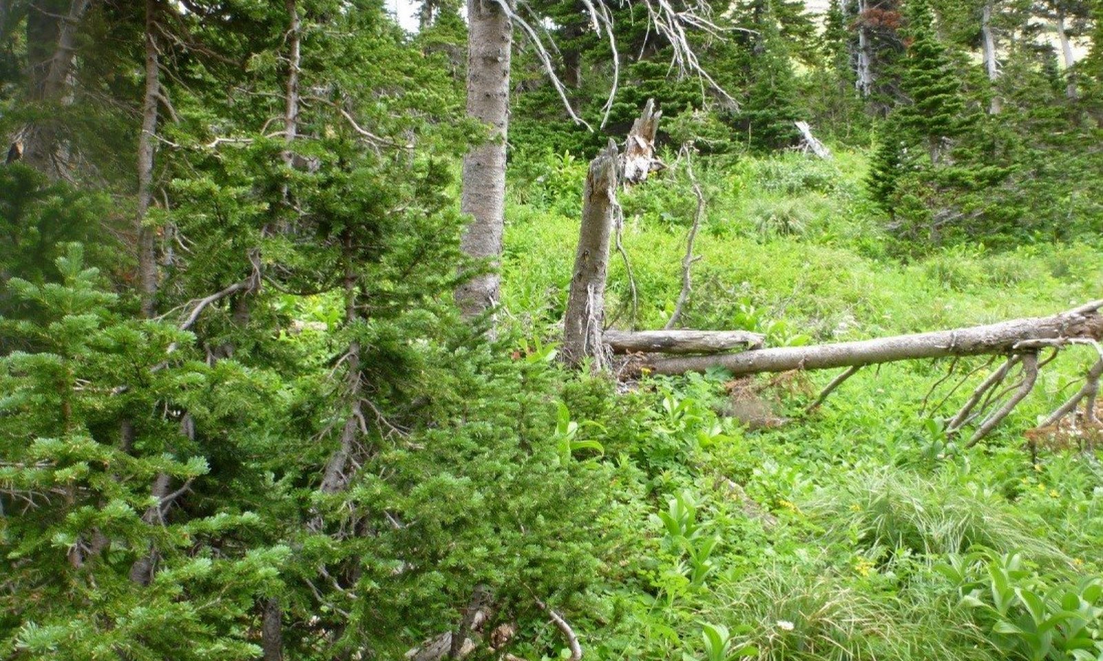
Reference Phase
Figure 13. View of this ecological site with high foliar cover of shrubs, grasses and forbs between tree ribbons. Trees at this ecological site are taller, not krummholtz.

Figure 14. Landscape view of site with thick understory of moderate to tall statured shrubs and forb species.

Figure 15. Site view noting lush understory of medium statured shrubs and taller tree islands with discontinuous fuel layer.
Structure: Multistory with small gap dynamics
The overstory is dominated by subalpine fir with small gap dynamics in which small numbers of trees are dead and conifer regeneration is infilling. The overstory tree canopy cover ranges from 15-35 percent. Understory foliar cover is typically high at this community phase (61.4%), and the ground cover is predominantly duff (85%) with low moss cover (4%) and gravel cover (6%). This ecological site has an indicator species of Hitchcock’s smooth woodrush, which is always present. The typical understory can be dominated by either beargrass, rusty menziesia or thinleaf huckleberry and has a diverse shrub component (11 sites of canopy cover). Only at two sites were there no shrubs present and the understory was dominated by Hitchcock’s smooth woodrush and yellow avalanche lily and lanceleaf springbeauty. From foliar data collected at 6 sites, the vegetation structure is one of moderately statured trees (9-15m or 30-49 or more feet tall), and a multilayered understory of medium-structured shrubs ranging from 76-102cm (30-40 inches) tall, and can include rusty menziesii, Scouler’s willow, Lyall’s angelica and current species. The next layer is 51-76cm (20-30 inches) tall and includes rose meadowsweet, cow parsnip and western meadowrue. The next layer is 25-51 cm (10-20 inches) tall and includes white spirea, thinleaf huckleberry, and beargrass. The lowest layer of forbs and grasses 3-25 cm (1-10 inches) tall includes fireweed, trailplant, Hitchcock’s woodrush, threeleaf foamflower and fragrant bedstraw. At these higher elevations subalpine fir is slow growing and infill can take several decades, sustaining the multistory structure of this community. The presence of root rot pockets can shift the composition of this community away from its host specie. This ecological site must have a presence of woodrush and sometimes this is dominant. At this phase Armillaria root rot, and to a minor degree defoliation by Western Spruce budworm, can be a threat.Forest overstory.Trees form a multi-storied stand of subalpine fir with lower cover of whitebark pine, lodgepole pine and Englemann spruce. The subcanopy is predominantly subalpine fir and lower cover of western larch, whitebark pine, lodgepole pine, Englemann spruce and Douglas fir. There may be pockets of quaking aspen.
Forest understory. The forest understory is diverse with multiple height shrub and herbaceous layers. Medium stature shrubs include thinleaf huckleberry, grouse whortleberry and rusty menziesia. Herbacous lower layers include heartleaf arnica, fireweed, yellow avalanche-lily.
Dominant plant species
-
subalpine fir (Abies lasiocarpa), tree
-
thinleaf huckleberry (Vaccinium membranaceum), shrub
-
grouse whortleberry (Vaccinium scoparium), shrub
-
rusty menziesia (Menziesia ferruginea), shrub
-
Hitchcock's smooth woodrush (Luzula glabrata var. hitchcockii), other herbaceous
-
heartleaf arnica (Arnica cordifolia), other herbaceous
-
yellow avalanche-lily (Erythronium grandiflorum), other herbaceous
-
fireweed (Chamerion angustifolium), other herbaceous
Figure 16. Annual production by plant type (representative values) or group (midpoint values)
Table 6. Soil surface cover
Tree basal cover 0-10% Shrub/vine/liana basal cover 0-10% Grass/grasslike basal cover 0-0% Forb basal cover 0-10% Non-vascular plants 0-10% Biological crusts 0-0% Litter 70-80% Surface fragments >0.25" and <=3" 0-10% Surface fragments >3" 0-10% Bedrock 0% Water 0% Bare ground 0-10% Table 7. Canopy structure (% cover)
Height Above Ground (ft) Tree Shrub/Vine Grass/
GrasslikeForb <0.5 0-5% 1-20% 0-2% 1-10% >0.5 <= 1 0-5% 1-20% 0-2% 0-10% >1 <= 2 0-5% 1-20% – 0-10% >2 <= 4.5 0-5% 0-5% – – >4.5 <= 13 0-5% – – – >13 <= 40 0-10% – – – >40 <= 80 5-20% – – – >80 <= 120 5-30% – – – >120 – – – – Community 1.2
Patchy Clumps, Single StoryStructure: High cover of herbaceous and shrub species with patchy clumps of regeneration of seedlings and saplings.
Community Phase 1.2 is a forest in the stand initiation phase, possibly with scattered remnant mature trees. The composition of the seedlings depends upon the natural seed sources available, which generally include whitebark pine, Engelmann spruce, subalpine fir, and subalpine larch. The canopy cover is very low. This phase is tolerant to Armillaria root rot in general.Community 1.3
Clumps of Single Story WhitebarkStructure: Clumps of single story conifer species including whitebark pine, Engelmann spruce, subalpine fir, and subalpine larch.
This phase may be tolerant to some types of Armillaria root rot strains and not others.Community 1.4
Stand Break Up by WindStructure: Mature trees of mixed conifers including whitebark pine, Engelmann spruce, subalpine fir, and subalpine larch.
Can be affected by Armillaria root rot.Pathway 1.1A
Community 1.1 to 1.2This pathway represents a larger disturbance: an insect infestation, wind storm, or rot pocket would create this forest structure. Areas of regeneration would range from approximately 2 to 5 acres.
Pathway 1.2A
Community 1.2 to 1.3This pathway represents continued growth over time with no further major disturbance.
Pathway 1.3A
Community 1.3 to 1.4This pathway represents continued growth over time with no further major disturbance.
Pathway 1.4A
Community 1.4 to 1.1This pathway represents continued growth over time with no further major disturbance.
Pathway 1.4B
Community 1.4 to 1.2This pathway represents major disturbance such as Armillaria root rot, stand-replacement fire, or pest outbreak.
State 2
Root RotAnother disease affecting the 43A UPPER SUBALPINE COLD CONIFEROUS ecological site is root rot. Armillaria root disease is the most common root disease fungus in this region, especially prevalent west of the Continental Divide. It may be difficult to detect until it has killed enough trees to create large root disease pockets or centers, ranging in size from a fraction of an acre to hundreds of acres. The root disease spreads from an affected tree to its surrounding neighbors through root contact. The root disease affects the most susceptible tree species first, leaving less susceptible tree species that mask its presence. When root rot is severe, the pocket has abundant regeneration or dense brush growth in the center. In western Montana and northern Idaho, Armillaria is present in most stands with diffuse mortality and large and small root disease centers. The disease pattern is one of multiple clones merging to form essentially continuous coverage of sites. Grouped as well as dispersed mortality can occur throughout the stand. A mosaic of brushy openings, patches of dying trees, and apparently unaffected trees may cover large areas. There can be highly significant losses, usually requiring species conversion in the active management approach. Management tactics include to identify the type of Armillaria root disease present and manage for pines and larch. Pre-commercial thinning may improve the growth and survival of pines and larch. Avoid harvests that leave susceptible species (usually Douglas-fir or true firs) as crop trees (Hagle, 2010). There has been a link determined between parent material and susceptibility to root disease, and metasedimentary parent material is thought to increase the risk of root disease. Glacier National Park is dominated by metasedimentary parent material, and may be more at risk than other areas to root disease (Kimsey et al., 2012). If a stand sustains very high levels of roots disease mortality, then a coniferous stand could cross a threshold and become a shrubland, once all conifers are gone (Kimsey et al., 2012).
Community 2.1
Armillatia Root RotMetasedimentary and quartzite parent material (vitrandic soils on south and west aspects). Shrubland with no trees.
Time=50yrsTransition T1A
State 1 to 2High density fir becomes infected.
Restoration pathway R2A
State 2 to 1Active management and seeding of true pine and larch species.
Additional community tables
Table 8. Community 1.1 plant community composition
Group Common name Symbol Scientific name Annual production () Foliar cover (%) Grass/Grasslike1 Sedges, rushes and woodrushes – Hitchcock's smooth woodrush LUGLH Luzula glabrata var. hitchcockii – 0–10 sedge CAREX Carex – 0–2 Forb2 Perennial and annual forbs – common beargrass XETE Xerophyllum tenax – 0–30 heartleaf arnica ARCO9 Arnica cordifolia – 0–5 yellow avalanche-lily ERGR9 Erythronium grandiflorum – 0–5 western meadow-rue THOC Thalictrum occidentale – 1–5 lanceleaf springbeauty CLLA2 Claytonia lanceolata – 0–2 rose meadowsweet SPSP2 Spiraea splendens – 0–2 meadow zizia ZIAP Zizia aptera – 0–2 wild bergamot MOFI Monarda fistulosa – 0–2 threeleaf foamflower TITR Tiarella trifoliata – 0–2 violet VIOLA Viola – 0–2 American trailplant ADBI Adenocaulon bicolor – 0–2 fragrant bedstraw GATR3 Galium triflorum – 0–2 bracted lousewort PEBR Pedicularis bracteosa – 0–2 common cowparsnip HEMA80 Heracleum maximum – 0–2 western sweetroot OSOC Osmorhiza occidentalis – 0–1 Rocky Mountain groundsel PAST10 Packera streptanthifolia – 0–1 arrowleaf ragwort SETR Senecio triangularis – 0–1 green false hellebore VEVI Veratrum viride – 0–1 Lyall's angelica ANAR3 Angelica arguta – 0–1 fireweed CHAN9 Chamerion angustifolium – 0–1 Shrub/Vine3 Shrubs and subshrubs – thinleaf huckleberry VAME Vaccinium membranaceum – 1–15 rusty menziesia MEFE Menziesia ferruginea – 1–10 Greene's mountain ash SOSC2 Sorbus scopulina – 0–5 white spirea SPBE2 Spiraea betulifolia – 0–5 creeping barberry MARE11 Mahonia repens – 0–5 currant RIBES Ribes – 0–5 dwarf bilberry VACE Vaccinium cespitosum – 0–2 Table 9. Community 1.1 forest overstory composition
Common name Symbol Scientific name Nativity Height ft Canopy cover (%) Diameter in Basal area (square ft/acre) Treesubalpine fir ABLA Abies lasiocarpa Native 50-100 10-40 15-35 0 subalpine fir ABLA Abies lasiocarpa Native 30-50 10-40 15-25 0 lodgepole pine PICO Pinus contorta Native 50-100 1-10 15-35 0 Engelmann spruce PIEN Picea engelmannii Native 50-100 1-5 15-35 0 whitebark pine PIAL Pinus albicaulis Native 30-80 1-5 15-35 0 Table 10. Community 1.1 forest understory composition
Common name Symbol Scientific name Nativity Height (ft) Canopy cover (%) Grass/grass-like (Graminoids)Hitchcock's smooth woodrush LUGLH Luzula glabrata var. hitchcockii Native – 1–60 alpine timothy PHAL2 Phleum alpinum Native – 2 mountain brome BRMA4 Bromus marginatus Native – 2 Geyer's sedge CAGE2 Carex geyeri Native – 1 sedge CAREX Carex Native – 0.5 blue wildrye ELGL Elymus glaucus Native – 0.5 Forb/Herbcommon beargrass XETE Xerophyllum tenax Native – 1–75 yellow avalanche-lily ERGR9 Erythronium grandiflorum Native – 0.5–20 western meadow-rue THOC Thalictrum occidentale Native – 1–20 lanceleaf springbeauty CLLA2 Claytonia lanceolata Native – 1–20 threeleaf foamflower TITR Tiarella trifoliata Native – 1–10 alpine leafybract aster SYFO2 Symphyotrichum foliaceum Native – 1–10 green false hellebore VEVI Veratrum viride Native – 0.5–10 heartleaf arnica ARCO9 Arnica cordifolia Native – 2–8 northern bedstraw GABO2 Galium boreale Native – 5 fireweed CHAN9 Chamerion angustifolium Native – 1–5 bracted lousewort PEBR Pedicularis bracteosa Native – 1–5 miterwort MITEL Mitella Native – 0.5–5 sweetcicely OSBE Osmorhiza berteroi Native – 5 liverleaf wintergreen PYAS Pyrola asarifolia Native – 0.5–5 bride's bonnet CLUN2 Clintonia uniflora Native – 3 common cowparsnip HEMA80 Heracleum maximum Native – 1–3 Lyall's angelica ANAR3 Angelica arguta Native – 0.5–3 claspleaf twistedstalk STAM2 Streptopus amplexifolius Native – 1–3 violet VIOLA Viola Native – 0.5–2 arrowleaf ragwort SETR Senecio triangularis Native – 1–2 broadleaf arnica ARLA8 Arnica latifolia Native – 1–2 fragrant bedstraw GATR3 Galium triflorum Native – 2 western rattlesnake plantain GOOB2 Goodyera oblongifolia Native – 1 manyflower stickseed HAFL2 Hackelia floribunda Native – 1 Indian paintbrush CASTI2 Castilleja Native – 1 meadow zizia ZIAP Zizia aptera Native – 1 American trailplant ADBI Adenocaulon bicolor Native – 1 American globeflower TRLAA2 Trollius laxus ssp. albiflorus Native – 1 darkwoods violet VIOR Viola orbiculata Native – 1 Sitka valerian VASI Valeriana sitchensis Native – 1 maiden blue eyed Mary COPA3 Collinsia parviflora Native – 1 Rocky Mountain groundsel PAST10 Packera streptanthifolia Native – 0.5–1 greenflowered wintergreen PYCH Pyrola chlorantha Native – 1 woodland buttercup RAUN Ranunculus uncinatus Native – 1 redstem saxifrage SALY3 Saxifraga lyallii Native – 1 western sweetroot OSOC Osmorhiza occidentalis Native – 0.5 wild bergamot MOFI Monarda fistulosa Native – 0.5 alumroot HEUCH Heuchera Native – 0.5 stinging nettle URDI Urtica dioica Native – 0.5 stonecrop SEDUM Sedum Native – 0.5 rockcress ARABI2 Arabis Native – 0.5 Fern/fern allycommon ladyfern ATFI Athyrium filix-femina Native – 3 western brackenfern PTAQ Pteridium aquilinum Native – 2 Shrub/Subshrubthinleaf huckleberry VAME Vaccinium membranaceum Native – 5–35 rusty menziesia MEFE Menziesia ferruginea Native – 5–30 thimbleberry RUPA Rubus parviflorus Native – 10 dwarf bilberry VACE Vaccinium cespitosum Native – 10 Sitka alder ALVIS Alnus viridis ssp. sinuata Native – 10 Utah honeysuckle LOUT2 Lonicera utahensis Native – 1–7 rose meadowsweet SPSPS Spiraea splendens var. splendens Native – 3–5 red elderberry SARA2 Sambucus racemosa Native – 3 Greene's mountain ash SOSC2 Sorbus scopulina Native – 3 currant RIBES Ribes Native – 1–3 gooseberry currant RIMO2 Ribes montigenum Native – 3 white spirea SPBE2 Spiraea betulifolia Native – 2 whortleberry VAMY2 Vaccinium myrtillus Native – 2 pink mountainheath PHEM Phyllodoce empetriformis Native – 1 twinberry honeysuckle LOIN5 Lonicera involucrata Native – 0.5 Table 11. Community 1.2 plant community composition
Group Common name Symbol Scientific name Annual production () Foliar cover (%) Table 12. Community 1.3 plant community composition
Group Common name Symbol Scientific name Annual production () Foliar cover (%) Table 13. Community 1.4 plant community composition
Group Common name Symbol Scientific name Annual production () Foliar cover (%) Table 14. Community 2.1 plant community composition
Group Common name Symbol Scientific name Annual production () Foliar cover (%) Interpretations
Supporting information
Other references
References
Arno, S. Forest Regions of Montana. USDA Forest Service Research Paper INT-218. USFS. USDA.
Arno, S. and R. Hammerly. Northwest Trees, by Stephen F. Arno and Ramona P. Hammerly. Anniversary Edition, the Mountaineers Books, 2007.
Arno S., D. Parsons and R. Keane. Mixed-Severity Fire Regimes in the Northern Rocky Mountains: Consequences of Fire Exclusion and Options for the Future. USDA Forest Service Proceedings RMRS-P-15-VOL-5.2000.
Barrett, S., S. Arno and C. Key. Fire regimes of western larch-lodgepole pine forests in Glacier National Park, Montana. 1991.
Bollenbacher, B. and P. Kolb, J. Morrison. 2013. Review Draft: Vulnerability, exposure, and sensitivity in restoring and maintaining the adaptive capacity of forest landscapes in the northern region of the Northern Rocky Mountains.
Bekker, Matthew F., and George P. Malanson. "Modeling feedback effects on linear patterns of subalpine forest
advancement." Developments in Earth Surface Processes 12 (2009): 167-190.
Billings, W. D. "Arctic and alpine vegetations: similarities, differences, and susceptibility to disturbance." BioScience 23.12 (1973): 697-704.
Butler, D. and G. Malanson, M. Bekker, L. Resler. Lithologic, structural, and geomorphic controls on ribbon forest patterns in a glaciated mountain environment. Geomorphology 55 (2003)203-217.
Butler, David R., Fagre., et al., eds. The Changing Alpine Treeline: The Example of Glacier National Park, MT, USA. Vol. 12. Elsevier, 2009.
Byler, James and Hagle, Susan. 2000. Succession functions of pathogens and insects. FHP Report No. 00-09.
Fins, Lauren, et al. "Return of the giants: restoring western white pine to the Inland Northwest." Journal of forestry 100.4 (2002): 20-26.
Fischer W., A. Bradley. Fire Ecology of Western Montana Forest Habitat Types. US Department of Agriculture. Forest Service. Intermountain Research Station. GTR-INT-223.
Garrison-Johnston, R. Lewis, L. Johnson. 2007. Northern Idaho and Western Montana Nutrition Guidelines by Rock Type. Intermountain Forest Tree Nutrition Cooperative. Forest Resources Department, University of Idaho.
Green, P. J. Joy, D. Sirucek, W. Hann, A. Zack, and B. Naumann. April 1992. Old Growth Criteria. R-1 SES 4/92. Northern Region. USDA USFS.
Hagle S., USFS, Forest Health Protection and State Forestry Organizations. Management Guide for Armillaria Root Disease. February 2008. WEB July 2010.
Hagle, Susan K. "Succession functions of forest pathogens and insects." (2000).
Haig, Irvine T., Kenneth P. Davis, and Robert H. Weidman. "Natural regeneration in the western white pine type." (1941).
Harvey, Alan E., et al. "Death of an ecosystem: perspectives on western white pine ecosystems of North America at the end of the twentieth century." (2008).
Hoff, Raymond J., Gerald I. McDonald, and Richard T. Bingham. Mass selection for blister rust resistance: a method for natural regeneration of western white pine. US Dept. of Agriculture, Forest Service, Intermountain Forest and Range Experiment Station, 1976.
Kimsey M., T. Shaw, M. Johnston, P. McDaniel. Intermountain Forest Tree Nutrition Cooperative. Ecological and physiological overview of volcanic soils and their influence on tree growth and vegetation.
Kimsey M. Intermountain Forest Tree Nutrition Cooperative. Geospatial tools for estimating and maintaining soil-site productivity. Northwest Forest Soils Council Meeting, February 28, 2012.
Loehman, Rachel A., Jason A. Clark, and Robert E. Keane. "Modeling effects of climate change and fire management on western white pine (Pinus monticola) in the Northern Rocky Mountains, USA." Forests 2.4 (2011): 832-860.
Losensky, J. L. "Personal communication. Jack Losensky." Ecologist, Lolo National Forest, Missoula, MT (1992).
Mahalovich, Mary F. "The role of genetics in improving forest health." (1995).
McDonald, A. Harvey and J. Tonn. USDA U.S.F.S., Rocky Mountain Research Station. Fire, competition and forest pests: landscape treatment to sustain ecosystem function.
McKenzie, D. and D. Tinker. 2012. Fire-induced shifts in overstory tree species composition and associated understory plant composition in Glacier National Park, Montana. Plant Ecology 2012: 213:207-224.
NatureServe, 2007. U.S. National Vegetation Classification Standard: Terrestrial Ecological Classifications. Waterton-Glacier International Peace Park, Local and Global Association Descriptions.
N.P.S. Fire Ecology Annual Report, Calendar Year 2014.
Pfister, R., B. Kovalchik, S. Arno, R. Presby. Forest Habitat Types of Montana. USDA Forest Service General Technical Report INT-34. Intermountain Forest and Range Experiment Station, US Department of Agriculture. May 1977.
Rockwell, F.I. 1917. Western white pine bulletin.
Soil Survey Staff. 2015. Illustrated guide to soil taxonomy. U.S. Department of Agriculture, Natural Resources Conservation Service, National Soil Survey Center, Lincoln, Nebraska.
USDA Forest Service. 1998. Flathead National Forest Plan Amendment 21, Final Environmental Impact Statement: Management Direction Related to Old Growth Forests. Flathead National Forest, Kalispell, MT.
USDA USFS Aerial Detection Survey Map, 2014.
Zack, A. Region One, Vegetation Classification, mapping, inventory and analysis report. U.S. Department of Agriculture, US Forest Service, Northern Region. Report 09-08 v1.0. 1997, revised 2005.Approval
Kirt Walstad, 3/11/2025
Rangeland health reference sheet
Interpreting Indicators of Rangeland Health is a qualitative assessment protocol used to determine ecosystem condition based on benchmark characteristics described in the Reference Sheet. A suite of 17 (or more) indicators are typically considered in an assessment. The ecological site(s) representative of an assessment location must be known prior to applying the protocol and must be verified based on soils and climate. Current plant community cannot be used to identify the ecological site.
Author(s)/participant(s) Contact for lead author Date 12/18/2020 Approved by Approval date Composition (Indicators 10 and 12) based on Annual Production Indicators
-
Number and extent of rills:
-
Presence of water flow patterns:
-
Number and height of erosional pedestals or terracettes:
-
Bare ground from Ecological Site Description or other studies (rock, litter, lichen, moss, plant canopy are not bare ground):
-
Number of gullies and erosion associated with gullies:
-
Extent of wind scoured, blowouts and/or depositional areas:
-
Amount of litter movement (describe size and distance expected to travel):
-
Soil surface (top few mm) resistance to erosion (stability values are averages - most sites will show a range of values):
-
Soil surface structure and SOM content (include type of structure and A-horizon color and thickness):
-
Effect of community phase composition (relative proportion of different functional groups) and spatial distribution on infiltration and runoff:
-
Presence and thickness of compaction layer (usually none; describe soil profile features which may be mistaken for compaction on this site):
-
Functional/Structural Groups (list in order of descending dominance by above-ground annual-production or live foliar cover using symbols: >>, >, = to indicate much greater than, greater than, and equal to):
Dominant:
Sub-dominant:
Other:
Additional:
-
Amount of plant mortality and decadence (include which functional groups are expected to show mortality or decadence):
-
Average percent litter cover (%) and depth ( in):
-
Expected annual annual-production (this is TOTAL above-ground annual-production, not just forage annual-production):
-
Potential invasive (including noxious) species (native and non-native). List species which BOTH characterize degraded states and have the potential to become a dominant or co-dominant species on the ecological site if their future establishment and growth is not actively controlled by management interventions. Species that become dominant for only one to several years (e.g., short-term response to drought or wildfire) are not invasive plants. Note that unlike other indicators, we are describing what is NOT expected in the reference state for the ecological site:
-
Perennial plant reproductive capability:
Print Options
Sections
Font
AAAAOther
PrintThe Ecosystem Dynamics Interpretive Tool is an information system framework developed by the USDA-ARS Jornada Experimental Range, USDA Natural Resources Conservation Service, and New Mexico State University.
Accessibility statement