
Natural Resources
Conservation Service
-
Search


Major Land Resource Area or ecological site by name and/or ID.
PreviousSectionsNextGeneral information
Provisional. A provisional ecological site description has undergone quality control and quality assurance review. It contains a working state and transition model and enough information to identify the ecological site.
Click to explore map
Figure 1. Mapped extent
Areas shown in blue indicate the maximum mapped extent of this ecological site. Other ecological sites likely occur within the highlighted areas. It is also possible for this ecological site to occur outside of highlighted areas if detailed soil survey has not been completed or recently updated.
Associated sites
R042CY151NM Limestone Hills
Limestone Hills occurs on limestone hills and footslopes of higher mountains. Slopes range from 10 to 60 percent. Soils are shallow, gravelly, and loamy. The reference plant community is mixed prairie grassland with scattered shrubs, forbs, and trees.
R042CY152NM Shallow
Shallow occurs on gravelly alluvial fans of higher limestone mountains. Slopes range from 5 to 20 percent. Soils are loamy, gravelly, and very shallow to a petrocalcic horizon also known as a root restricting layer. The reference plant community is mixed prairie grassland with scattered shrubs, trees, and forbs.
R042CY156NM Gravelly
Gravelly occurs on gravelly alluvial fans of higher limestone mountains. Slopes range from 5 to 20 percent. Soils are deep gravelly loams. The reference plant community is mixed prairie grassland with scattered shrubs, trees, and forbs.
Table 1. Dominant plant species
Tree Not specified
Shrub Not specified
Herbaceous Not specified
Physiographic features
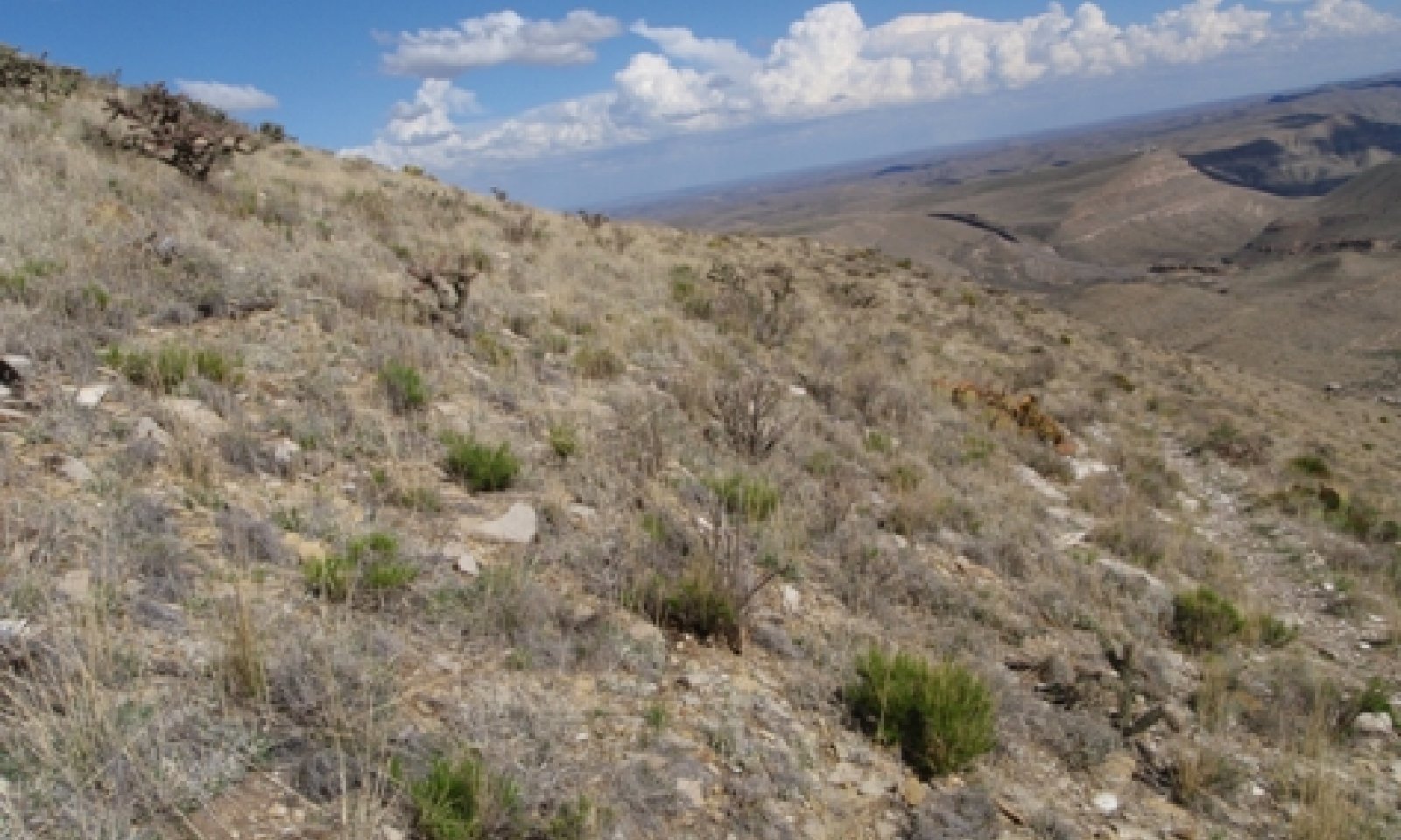
The site occurs on sandstone hills, hillslopes, and ridges. Slopes range from 10 to 60 percent.
Table 2. Representative physiographic features
Landforms (1) Hill
(2) Ridge
Elevation 4500 – 5500 ft Slope 5 – 20 % Aspect N, S Climatic features
The climate of this area is “semi-arid continental.”
Annual average precipitation ranges from 11 to 19 inches. Variations of 5 inches, more or less, are not uncommon. Approximately 70 percent of the precipitation occurs from May through October. Most of the summer rain comes in the form of high-intensity, short- uration thunderstorms. Winter moisture is usually negligible.
Temperatures are characterized by distinct seasonal changes and large annual and diurnal temperature changes. The average annual temperature ranges from 55 degrees to 60 degrees, with extremes of 20 degrees below zero in the winter to 110 degrees in the summer not uncommon.
The average frost-free season is 170 to 189 days. The last killing frost is in early April and the first killing frost is in mid October.
Both temperature (especially south slope)and precipitation favor warm-season species. However, approximately 40 percent of the precipitation (and temperature on north slopes) is favorable to to cool season growth at the middle to higher elevations. This could allow the cool season plants to occupy a very important part of this complex plant community. Due to the shallow soil profile, vegetation responds well to light rains. Moisture can also be stored relatively deep in the seams and cracks of fractured limestone. This moisture is also available for plant use. Slope aspect is also important when the strong winds from the west and southwest blow. These winds, which blow from February to June, cause the soil to dry during the critical growth stage for many cool season species. The north slopes are somewhat protected and do not dry as fast as the south slopes.
Climate data was obtained from http://www.wrcc.sage.dri.edu/summary/climsmnm.html web site.
Data interpreted utilizing NM NRCS Climate Summarizer spreadsheet.
Table 3 Representative climatic features
Frost-free period (average) 190 days Freeze-free period (average) 210 days Precipitation total (average) 20 in BarLineFigure 2. Monthly precipitation range
BarLineFigure 3. Monthly average minimum and maximum temperature
">Influencing water features
None.
Soil features
The site consists of very shallow or shallow, well drained, and moderately permeable soils over very slowly permeable fractured sandstone bedrock. Parent material is loamy residuum and colluvium weathered from Permian sandstone. Typically, the surface layer is light brown, very channery sandy loam about 3.5 inches thick. The subsurface layer ranges from 3.5 to 11 inches in light brown extremely gravelly sandy loam. The underlying material from 11 inches to 21 inches is fractured sandstone bedrock.
The soil components and associated map units correlated to this site are:
Guadalupe Mountains National Park Soil Survey:
Bonespring very gravelly loam, 1 to 8 percent slopes
Table 4. Representative soil features
Parent material (1) Residuum – sandstone
Surface texture (1) Very channery sandy loam
(2) Very channery fine sandy loam
Family particle size (1) Loamy
Drainage class Well drained Permeability class Very slow Soil depth 3 – 18 in Surface fragment cover <=3" 10 – 35 % Surface fragment cover >3" 10 – 25 % Available water capacity
(0-40in)0 – 2 in Calcium carbonate equivalent
(0-40in)0 – 13 % Electrical conductivity
(0-40in)Not specified Sodium adsorption ratio
(0-40in)Not specified Soil reaction (1:1 water)
(0-40in)7.4 – 8.4 Subsurface fragment volume <=3"
(Depth not specified)30 – 40 % Subsurface fragment volume >3"
(Depth not specified)4 – 15 % Ecological dynamics
The reference or current potential plant community for the Sandstone Hill ecological site is a mid and shortgrass and predominantly warm-season grama grassland interspersed with mixed shrubs. Grass, shrub and forb canopy cover ranges from 65-75, 5-20, and 1-5 percent, respectively. Surface fragment cover can range up to 75 percent. The scale of the plant community for measurement is the associated soil component within the soil map units.
Fluctuations in yearly weather conditions is probably the most influential factor that helps shape the plant communities. Prolonged droughts will dramatically reduce herbaceous cover and production while wet summers will favor black grama dominance and wet winters will favor more mesic and cool-season grasses (Ludwig et al. 2000). Aspect, elevation, soil variability, and percentage of rock outcrop also play a role in shape the inherent plant community. Lightning induced fires do occur in the area but the exact frequency is unknown.
It is unknown whether bison utilized this site historically. Slope, the rough topography, and lack of abundant perennial water may limited or prevented them from utilizing the site. Desert bighorn sheep probably utilized this site historically for part of their habitat needs. Other native fauna such as insects, rodents, mule deer, and pronghorn antelope are still helping influence the current plant communities.
The site is suited for prescribed grazing practices. Heavy continuous grazing, especially during dry years, over long periods will cause decreases in plants such as blue grama, black grama and increases in less palatable grasses such as sideoats grama, hairy grama, tridens, fluffgrass, and threeawns. In addition, woody plants may increase in areas where the seed source is available. Ecological processes such as water and nutrient cycles may also be affected by improper grazing management.
An inclusion plant community that is significantly different is also included in this ecological site due to its managerial importance within Guadalupe Mountains National Park. This Savannah State does not transition or restore to the Grassland or Shrubland State. Currently, this state has not been described outside the park. It is a gray oak – alligator juniper savanna with pine muhly, New Mexico muhly, cane bluestem, sideoats grama, New Mexico feathergrass, and blue grama as common grasses. This community grows in a wetter and cooler climate than the rest of the described Sandstone Hill ecological site. It grows in a more mesic portion of the ecological site is not a part of the dynamics of the warm-season grassland with shrubs that characterizes the majority of the Sandstone Hill site. The fire management plan of the park identifies this area as Madrean Evergreen Woodland. Fire plays an important role in maintaining an open savanna. The Woodland – Grassland dynamic potentially exists in this system.
The following diagram suggests general pathways that the vegetation on this site might follow. There are other plant communities and states not shown on the diagram. This information is intended to show what might happen in a given set of circumstances; it does not mean that this would happen the same way in every instance. Local professional guidance should always be sought before pursuing a treatment scenario.
State and Transition Model:
State and transition model
Custom diagramStandard diagram
More interactive model formats are also available. View Interactive Models
More interactive model formats are also available. View Interactive Models
Click on state and transition labels to scroll to the respective textState 1 submodel, plant communities
State 2 submodel, plant communities
State 3 submodel, plant communities
State 1
Grassland StateThe Grama/Shrubs plant community phase is the reference or current potential vegetative community. Characteristic grasses include sideoats grama, black grama, blue grama, Warnock’s grama, curlyleaf muhly, and New Mexico feathergrass. Shifts in above average winter or summer precipitation can shift dominance from either black grama or sideoats to cool-season grasses. It is unknown if the higher shrub cover in some locations is attributed to past management or it is part of the natural variability of the site. Shrub canopy cover over 25 percent will categorize the site in the Shrubland State. Annual production ranges from 600 to 1400 pounds per acre.
The Threeawns/Shrubs Community is a response to heavy continuous grazing. Drought will only exacerbate the situation. Perennial grass cover is lower and dominated by mainly perennial threeawns, hairy grama, and slim tridens. Both annual and perennial forbs will also increase in relative composition. Palatable grasses such as black grama and blue grama have decreased in cover. Shrubs may begin to encroach in certain areas.
Community 1.1
Gramas/Shrubs Community
Figure 4. 1.1 Gramas/Shrubs Community
The Grama/Shrubs Community is the reference or current potential vegetative community. Characteristic grasses include sideoats grama, black grama, blue grama, Warnock’s grama, curlyleaf muhly, and New Mexico feathergrass. Shifts in above average winter or summer precipitation can shift dominance from either black grama or sideoats to cool-season grasses. In addition, the more mesic grasses such as sideoats grama, blue grama, and curlyleaf muhly will inherently be more abundant on north facing slopes while black grama will dominate south-facing slope. A variety of shrubs occurs sporadically and is characterized by winterfat, skeletonleaf goldeneye, ephedra, mariola, mountain mahogany, and New Mexico agave. Canopy cover of shrubs can range from 5-20 percent. It is unknown if the higher shrub cover in some locations is attributed to past management or it is part of the natural variability of the site. Shrub canopy cover over 25 percent will categorize the site in the Shrubland State. Annual production ranges from 600 to 1400 pounds per acre.
The site is suited for livestock grazing and provides important wildlife habitat. Heavy continuous grazing over several years can reduce and potentially eliminate black and blue grama. Sideoats grama, threeawns, slim tridens, and hairy grama will increase. If there is an available seed source, shrubs may begin to encroach on the site.
Figure 5. Annual production by plant type (representative values) or group (midpoint values)
Table 5. Annual production by plant type
Plant type Low
(lb/acre)Representative value
(lb/acre)High
(lb/acre)Grass/Grasslike 600 820 1200 Shrub/Vine 75 140 150 Forb 25 40 50 Tree 0 0 0 Total 700 1000 1400 Table 6. Ground cover
Tree foliar cover 0% Shrub/vine/liana foliar cover 10-20% Grass/grasslike foliar cover 50-70% Forb foliar cover 0-10% Non-vascular plants 0% Biological crusts 0% Litter 0% Surface fragments >0.25" and <=3" 0% Surface fragments >3" 0% Bedrock 0% Water 0% Bare ground 0% Table 7. Canopy structure (% cover)
Height Above Ground (ft) Tree Shrub/Vine Grass/
GrasslikeForb <0.5 – 0-2% 5-10% 1-3% >0.5 <= 1 – 1-5% 30-35% 1-2% >1 <= 2 – 1-5% 25-30% – >2 <= 4.5 – 3-10% – – >4.5 <= 13 – – – – >13 <= 40 – – – – >40 <= 80 – – – – >80 <= 120 – – – – >120 – – – – Figure 6. Plant community growth curve (percent production by month). TX0030 , Mixed Grama/Muhly Grassland Community. Mixed grama/muhly grassland characterized by blue grama, sideoats, grama, black grama, and curly leaf muhly. .
Jan Feb Mar Apr May Jun Jul Aug Sep Oct Nov Dec J F M A M J J A S O N D 1 1 1 3 3 10 15 25 25 10 5 1 Community 1.2
Threeawns/Shrubs CommunityThis plant community is a response to heavy continuous grazing. Drought will only exacerbate the situation. Perennial grass cover is lower and dominated by mainly perennial threeawns, hairy grama, and slim tridens. Both annual and perennial forbs will also increase in relative composition. Palatable grasses such as black grama and blue grama have decreased in cover. Shrubs may begin to encroach in certain areas.
Pathway 1.1A
Community 1.1 to 1.2Heavy continuous grazing is the major driver causing this transition. Drought will only hasten the transition. Palatable grasses favored by livestock such as blue grama and black grama have decreased in cover while less palatable grasses such as tridens, perennial threeawns, fluffgrass, sideoats grama, and hairy grama have increased in cover. Time period for this transition is probably less than 10 years.
Pathway 1.2A
Community 1.2 to 1.1A combination of favorable rainfall and conservation practices such as prescribed grazing and/or planned grazing system can help facilitate the recovery of grasses more palatable to livestock. Rate of recovery will depend on the extent to which the site has been disturbed.
Conservation practices
Prescribed Grazing State 2
Shrubland StateThe Shrubs/Grama Community is noted for lower perennial grass cover and is dominated by sideoats grama, slim tridens and threeawns. Both annual and perennial forbs will also increase in relative composition. Palatable grasses such as black grama and blue grama have decreased in cover. Shrub canopy cover is greater than 25 percent.
The Shrubs/Threeawn Community has unknown past reference concerning whether if this community is attributed to past disturbances such as heavy continuous grazing or if these areas are within the inherent variability of the site. Nonetheless, shrubs can comprise greater than 25 percent cover in areas. Common shrubs include sotol, lechuguilla, sacahuista, and creosotebush. This community can provide habitat for some wildlife that the grassland community is not able to provide.
Community 2.1
Shrubs/Gramas CommunityIt is unknown if this community is attributed to past disturbances such as heavy continuous grazing or if these areas are within the inherent variability of the site. Nonetheless, shrubs can comprise greater than 25 percent cover in areas. Common shrubs include sotol, lechuguilla, sacahuista, and creosotebush. This community can provide habitat for some wildlife that the grassland community is not able to provide.
Community 2.2
Shrubs/Threeawns CommunityThis plant community is a response to heavy continuous grazing. Drought will only exacerbate the situation. Perennial grass cover is lower and dominated by sideoats grama, slim tridens and threeawns. Both annual and perennial forbs will also increase in relative composition. Palatable grasses such as black grama and blue grama have decreased in cover. Shrub canopy cover is greater than 25 percent.
Pathway 2.1A
Community 2.1 to 2.2Heavy continuous grazing is the major driver causing this transition. Drought will only hasten the transition. Palatable grasses favored by livestock such as blue grama and black grama have decreased in cover while less palatable grasses such as tridens, perennial threeawns, fluffgrass, sideoats grama, and hairy grama have increased in cover. Time period for this transition is probably less than 10 years.
Pathway 2.2A
Community 2.2 to 2.1A combination of favorable rainfall and conservation practices such as prescribed grazing and/or planned grazing system can help facilitate the recovery of grasses more palatable to livestock. Rate of recovery will depend on the extent to which the site has been disturbed.
Conservation practices
Prescribed Grazing State 3
Savanna State (Inclusion State)The Muhlys-Gramas/Oak-Juniper plant community is an inclusion that occurs in a cooler and wetter soil temperature regime. Soils still remain shallow to mostly sandstone with some areas derived from limestone. The reference plant community is a gray oak – alligator juniper savanna with abundant warm- and cool-season perennial bunchgrasses such as pine muhly, bull muhly, sideoats grama, and New Mexico feathergrass. Scattered shrubs include skunkbush sumac, cholla, and wavyleaf oak. Annual production ranges from 1350 to 2600 pounds per acre.
The Threeawns/Oak-Juniper plant community phase results from overgrazing. A shift from decreaser grasses (palatable) to increaser (unpalatable) dominance has occurred. The community is more susceptible to woody plant encroachment due the overall decline of herbaceous plants and the fuel to carry fire. Threeawns and hairy grama are common increaser grasses. Decreaser grasses include blue grama and the various muhlenbergia species.
The Woodland/Mixed-grass plant community results from fire suppression and/or livestock overgrazing. A shift from decreaser grasses (palatable) to increaser (unpalatable) dominance has occurred. Further woody plant encroachment occurs due to the overall decline of herbaceous plants and the lack of fuel to carry fire. Threeawns and hairy grama are common increaser grasses. Decreaser grasses include blue grama and the various muhlenbergia species.
Community 3.1
Muhlys-Gramas/Oak-Juniper Community
Figure 7. 3.1 Muhlys-Gramas/Oak-Juniper Community
This plant community is an inclusion within the Bonespring map unit that occurs in a cooler and wetter soil temperature regime. Soils still remain shallow to mostly sandstone with some areas derived from limestone. At Guadalupe Mountains National Park, it is found on the north facing slopes of Pine Spring Canyon and the north face slopes of the foothills of Frijole Ridge. According to the park’s Fire Management Plan, this area is referred to as the Madrean Evergreen Woodland. The reference plant community is a gray oak – alligator juniper savanna with abundant warm- and cool-season perennial bunchgrasses such as pine muhly, bull muhly, sideoats grama, and New Mexico feathergrass. Scattered shrubs include skunkbush sumac, cholla, and wavyleaf oak. Annual production ranges from 1350 to 2600 pounds per acre.
Similar open savanna communities such as this one are typically maintained by a fire interval of 10-30 years (Abbott 1998). The few scattered woody plants allows for maximum herbaceous production that ultimately provides the fuel to carry fires. Fire suppression either alone or in combination with overgrazing will allow woody plants to increase at the expense of herbaceous plants.
Conservation practices such as prescribed fire and prescribed grazing will help maintain an open savanna or oak woodland.
Figure 8. Annual production by plant type (representative values) or group (midpoint values)
Table 8. Annual production by plant type
Plant type Low
(lb/acre)Representative value
(lb/acre)High
(lb/acre)Grass/Grasslike 1000 1400 1800 Tree 200 400 500 Shrub/Vine 100 200 300 Forb 50 75 100 Total 1350 2075 2700 Community 3.2
Threeawns/Oak-Juniper CommunityThis plant community phase results from overgrazing. A shift from decreaser grasses (palatable) to increaser (unpalatable) dominance has occurred. The community is more susceptible to woody plant encroachment due the overall decline of herbaceous plants and the fuel to carry fire. Threeawns and hairy grama are common increaser grasses. Decreaser grasses include blue grama and the various muhlenbergia species.
Community 3.3
Woodland/Mixed-grass CommunityThis plant community phase results from fire suppression and/or livestock overgrazing. A shift from decreaser grasses (palatable) to increaser (unpalatable) dominance has occurred. Further woody plant encroachment occurs due to the overall decline of herbaceous plants and the lack of fuel to carry fire. Threeawns and hairy grama are common increaser grasses. Decreaser grasses include blue grama and the various muhlenbergia species.
Pathway 3.1A
Community 3.1 to 3.2The Muhlys-Gramas/Oak-Juniper Community transitions into the Threeawns/Oak-Juniper Community through the use of heavy continuous grazing and exacerbated drought conditions.
Pathway 3.2A
Community 3.2 to 3.1The shift from the Threeawns/Oak-Juniper Community to the Muhlys-Gramas/Oak-Juniper Community occurs when Prescribed Grazing is applied and/or favorable precipitation exists.
Conservation practices
Prescribed Grazing Pathway 3.2B
Community 3.2 to 3.3The Threeawns/Oak-Juniper Community transitions into the Woodland/Mixed-grass Community through the use of heavy continuous grazing and exacerbated drought conditions.
Pathway 3.3A
Community 3.3 to 3.2The shift from the Woodland/Mixed-grass Community to the Threeawns/Oak-Juniper Community occurs when Prescribed Grazing and/or favorable precipitation is applied.
Conservation practices
Prescribed Grazing Transition T1A
State 1 to 2The grassland state transitions to the shrubland state when shrub cover is higher than 25 percent. It is unknown if the transition is attributed to past disturbances such as heavy continuous grazing or if these areas are within the inherent variability of the site. Nonetheless, shrubs can comprise greater than 25 percent cover in areas. Common increaser shrubs include sotol, broomweed, sacahuista, and mariola.
Restoration pathway R2A
State 2 to 1Rangeland conservation practices such as brush management and possibly prescribed burning (where amount of fine fuel is adequate) can restore the Shrubland State into the Grassland State.
Conservation practices
Brush Management Prescribed Burning Prescribed Grazing Additional community tables
Table 9. Community 1.1 plant community composition
Group Common name Symbol Scientific name Annual production () Foliar cover (%) Grass/Grasslike1 Warm-season stoloniferous grasses 200–300 black grama BOER4 Bouteloua eriopoda 200–300 – 2 Dominant warm-season bunchgrasses 200–300 sideoats grama BOCU Bouteloua curtipendula 100–200 – blue grama BOGR2 Bouteloua gracilis 50–150 – Warnock's grama BOWA Bouteloua warnockii 50–150 – 3 Subdominant warm-season bunchgrasses 75–100 hairy grama BOHI2 Bouteloua hirsuta 15–30 – common wolfstail LYPH Lycurus phleoides 15–30 – Hall's panicgrass PAHA Panicum hallii 15–30 – hairy woollygrass ERPI5 Erioneuron pilosum 10–25 – threeawn ARIST Aristida 10–25 – sand dropseed SPCR Sporobolus cryptandrus 10–25 – slim tridens TRMU Tridens muticus 10–25 – curlyleaf muhly MUSE Muhlenbergia setifolia 5–15 – plains lovegrass ERIN Eragrostis intermedia 5–15 – streambed bristlegrass SELE6 Setaria leucopila 5–15 – 4 Cool-season bunchgrasses 75–100 southwestern needlegrass ACEM4 Achnatherum eminens 60–150 – New Mexico feathergrass HENE5 Hesperostipa neomexicana 15–30 – Shrub/Vine5 Shrubs 30–60 viscid acacia ACNE4 Acacia neovernicosa 5–20 – desert ceanothus CEGR Ceanothus greggii 5–20 – alderleaf mountain mahogany CEMO2 Cercocarpus montanus 5–20 – Guadalupe rabbitbrush CHSP3 Chrysothamnus spathulatus 5–20 – javelina bush COER5 Condalia ericoides 5–20 – rough jointfir EPAS Ephedra aspera 5–20 – eggleaf silktassel GAOV Garrya ovata 5–20 – Pinchot's juniper JUPI Juniperus pinchotii 5–20 – winterfat KRLA2 Krascheninnikovia lanata 5–20 – Big Bend barometerbush LEMI4 Leucophyllum minus 5–20 – algerita MATR3 Mahonia trifoliolata 5–20 – Rio Grande saddlebush MOSC Mortonia scabrella 5–20 – mariola PAIN2 Parthenium incanum 5–20 – skunkbush sumac RHTR Rhus trilobata 5–20 – 6 Subshrubs 5–10 featherplume DAFO Dalea formosa 2–5 – littleleaf ratany KRER Krameria erecta 2–5 – woody crinklemat TICAC Tiquilia canescens var. canescens 2–5 – 7 Fibrous/Succulents 15–30 Parry's agave AGPAN6 Agave parryi ssp. neomexicana 5–15 – tree cholla CYIMI Cylindropuntia imbricata var. imbricata 5–15 – green sotol DALE2 Dasylirion leiophyllum 5–15 – Texas sacahuista NOTE Nolina texana 5–15 – pricklypear OPUNT Opuntia 5–15 – banana yucca YUBA Yucca baccata 5–15 – soaptree yucca YUEL Yucca elata 5–15 – Forb8 Forbs 10–35 Forb, perennial 2FP Forb, perennial 6–15 – hairyseed bahia BAAB Bahia absinthifolia 1–3 – leatherweed CRPO5 Croton pottsii 1–3 – Cooley's bundleflower DECO2 Desmanthus cooleyi 1–3 – buckwheat ERIOG Eriogonum 1–3 – broom snakeweed GUSA2 Gutierrezia sarothrae 1–3 – needleleaf bluet HOACP2 Houstonia acerosa var. polypremoides 1–3 – plains blackfoot MELE2 Melampodium leucanthum 1–3 – menodora MENOD Menodora 1–3 – beardtongue PENST Penstemon 1–3 – polygala POLYG Polygala 1–3 – longstalk greenthread THLO Thelesperma longipes 1–3 – noseburn TRAGI Tragia 1–3 – 9 Forbs 6–15 Forb, annual 2FA Forb, annual 0–10 – woolly plantain PLPA2 Plantago patagonica 0–10 – Table 10. Community 1.2 plant community composition
Group Common name Symbol Scientific name Annual production () Foliar cover (%) Table 11. Community 2.1 plant community composition
Group Common name Symbol Scientific name Annual production () Foliar cover (%) Table 12. Community 2.2 plant community composition
Group Common name Symbol Scientific name Annual production () Foliar cover (%) Table 13. Community 3.1 plant community composition
Group Common name Symbol Scientific name Annual production () Foliar cover (%) Grass/Grasslike1 Muhlenbergia spp. 450–810 pine muhly MUDU Muhlenbergia dubia 125–300 – bullgrass MUEM Muhlenbergia emersleyi 125–300 – New Mexico muhly MUPA2 Muhlenbergia pauciflora 100–250 – slimflower muhly MUTE Muhlenbergia tenuiflora 100–250 – 2 Midgrasses 300–540 cane bluestem BOBA3 Bothriochloa barbinodis 75–250 – sideoats grama BOCU Bouteloua curtipendula 75–250 – blue grama BOGR2 Bouteloua gracilis 75–250 – plains lovegrass ERIN Eragrostis intermedia 75–250 – common wolfstail LYPH Lycurus phleoides 50–150 – 3 Shortgrasses 150–270 threeawn ARIST Aristida 50–100 – hairy grama BOHI2 Bouteloua hirsuta 50–100 – hairy woollygrass ERPI5 Erioneuron pilosum 50–100 – 4 Cool-season bunchgrasses 100–180 New Mexico feathergrass HENE5 Hesperostipa neomexicana 75–150 – pinyon ricegrass PIFI Piptochaetium fimbriatum 25–90 – Shrub/Vine5 Shrubs 75–200 white sagebrush ARLUM2 Artemisia ludoviciana ssp. mexicana 25–75 – brickellbush BRICK Brickellia 25–75 – featherplume DAFO Dalea formosa 25–75 – catclaw mimosa MIACB Mimosa aculeaticarpa var. biuncifera 25–75 – pungent oak QUPU Quercus pungens 25–75 – fragrant sumac RHAR4 Rhus aromatica 25–75 – littleleaf sumac RHMI3 Rhus microphylla 25–75 – 6 Fibrous/Succulents 25–100 tree cholla CYIMI Cylindropuntia imbricata var. imbricata 5–25 – Texas sacahuista NOTE Nolina texana 5–25 – tulip pricklypear OPPH Opuntia phaeacantha 10–25 – soaptree yucca YUEL Yucca elata 5–25 – Forb7 Forbs 50–100 Forb, perennial 2FP Forb, perennial 20–50 – awnless bushsunflower SICA7 Simsia calva 10–25 – Forb, annual 2FA Forb, annual 10–25 – vervain VERBE Verbena 3–10 – milkvetch ASTRA Astragalus 3–10 – Tree8 Trees 200–500 alligator juniper JUDE2 Juniperus deppeana 100–400 – gray oak QUGR3 Quercus grisea 100–400 – Texas madrone ARXA80 Arbutus xalapensis 50–200 – Table 14. Community 3.2 plant community composition
Group Common name Symbol Scientific name Annual production () Foliar cover (%) Table 15. Community 3.3 plant community composition
Group Common name Symbol Scientific name Annual production () Foliar cover (%) Interpretations
Animal community
The reference plant community is suited for conservative livestock grazing by cattle, horses, burros, and sheep and goats. Livestock should be stocked in proportion to the grazeable grass, forbs, and browse. Improper grazing management, especially during droughts, causes a gradual decline in range health, reducing livestock nutrition and habitat quality for some wildlife.
Wildlife that use this site for at least a portion of their overall habitat needs include mule deer, pronghorn antelope, desert bighorn sheep, coyotes, black-tailed jackrabbits, cottontails, mice, and ground squirrels. Birds that use this site as for at least a portion of their habitat needs include scaled quail, dove, raptors, and numerous song birds. Insects and reptiles such as rattlesnakes and lizards also frequent the area.
Plant Preference by Animal Kind:
These preferences are somewhat general in nature as the preferences for plants is dependent upon grazing experience, time of year, availability of choices, and total forage supply.
Legend: P=Preferred D=Desirable U=Undesirable N=Not Consumed T=Toxic X=Used, but not degree of utilization unknown
Preferred – Percentage of plant in animal diet is greater than it occurs on the land
Desirable – Percentage of plant in animal diet is similar to the percentage composition on the land
Undesirable – Percentage of plant in animal diet is less than it occurs on the land
Not Consumed – Plant would not be eaten under normal conditions. Only consumed when other forages are not available.
Toxic – Rare occurrence in diet and, if consumed in any tangible amounts results in death or severe illness in animal
Hydrological functions
The site is located in both a surface water run-in and runoff position. Surface rock fragments and a high grass cover help reduce runoff potential especially on hill slopes. A reduction in grass and ground cover will impair the hydrologic function of the site by increasing surface runoff and decreasing water infiltration.
Recreational uses
The site can be used for hiking and hunting.
Wood products
None.
Other products
None.
Other information
None.
Supporting information
Inventory data references
Information presented here has been developed from NRCS clipping, composition, plant cover, soils data and ecological interpretations gained by field observation.
Other references
Reviewers:
Mark Moseley, Rangeland Management Specialist, NRCS, Boerne, TX
Contributors
Michael Margo
Michael Margo, RMS, NRCS, Marfa, TexasRangeland health reference sheet
Interpreting Indicators of Rangeland Health is a qualitative assessment protocol used to determine ecosystem condition based on benchmark characteristics described in the Reference Sheet. A suite of 17 (or more) indicators are typically considered in an assessment. The ecological site(s) representative of an assessment location must be known prior to applying the protocol and must be verified based on soils and climate. Current plant community cannot be used to identify the ecological site.
Author(s)/participant(s) Contact for lead author Date Approved by Approval date Composition (Indicators 10 and 12) based on Annual Production Indicators
-
Number and extent of rills:
-
Presence of water flow patterns:
-
Number and height of erosional pedestals or terracettes:
-
Bare ground from Ecological Site Description or other studies (rock, litter, lichen, moss, plant canopy are not bare ground):
-
Number of gullies and erosion associated with gullies:
-
Extent of wind scoured, blowouts and/or depositional areas:
-
Amount of litter movement (describe size and distance expected to travel):
-
Soil surface (top few mm) resistance to erosion (stability values are averages - most sites will show a range of values):
-
Soil surface structure and SOM content (include type of structure and A-horizon color and thickness):
-
Effect of community phase composition (relative proportion of different functional groups) and spatial distribution on infiltration and runoff:
-
Presence and thickness of compaction layer (usually none; describe soil profile features which may be mistaken for compaction on this site):
-
Functional/Structural Groups (list in order of descending dominance by above-ground annual-production or live foliar cover using symbols: >>, >, = to indicate much greater than, greater than, and equal to):
Dominant:
Sub-dominant:
Other:
Additional:
-
Amount of plant mortality and decadence (include which functional groups are expected to show mortality or decadence):
-
Average percent litter cover (%) and depth ( in):
-
Expected annual annual-production (this is TOTAL above-ground annual-production, not just forage annual-production):
-
Potential invasive (including noxious) species (native and non-native). List species which BOTH characterize degraded states and have the potential to become a dominant or co-dominant species on the ecological site if their future establishment and growth is not actively controlled by management interventions. Species that become dominant for only one to several years (e.g., short-term response to drought or wildfire) are not invasive plants. Note that unlike other indicators, we are describing what is NOT expected in the reference state for the ecological site:
-
Perennial plant reproductive capability:
Print Options
Sections
Font
AAAAOther
PrintThe Ecosystem Dynamics Interpretive Tool is an information system framework developed by the USDA-ARS Jornada Experimental Range, USDA Natural Resources Conservation Service, and New Mexico State University.
Accessibility statement


