
Natural Resources
Conservation Service
-
Search


Major Land Resource Area or ecological site by name and/or ID.
PreviousSectionsNextGeneral information
Provisional. A provisional ecological site description has undergone quality control and quality assurance review. It contains a working state and transition model and enough information to identify the ecological site.
Click to explore map
Figure 1. Mapped extent
Areas shown in blue indicate the maximum mapped extent of this ecological site. Other ecological sites likely occur within the highlighted areas. It is also possible for this ecological site to occur outside of highlighted areas if detailed soil survey has not been completed or recently updated.
Ecological site concept
This site occurs on upland plains, fans, mesas, and drainageways. Slopes range from 0 to 6 percent.
The soils of this site are deep to moderately deep and well drained. Surface textures are gravelly loams and gravelly fine sandy loams. Because of relatively high fragment content throughout the profile, water holding capacity is low.Associated sites
R042CY151NM Limestone Hills
Limestone Hills occurs on limestone hills and footslopes of higher mountains. Slopes range from 10 to 60 percent. Soils are shallow, gravelly, and loamy. The reference plant community is mixed prairie grassland with scattered shrubs, forbs, and trees.
R042CY152NM Shallow
Shallow occurs on gravelly alluvial fans of higher limestone mountains. Slopes range from 5 to 20 percent. Soils are loamy, gravelly, and very shallow to a petrocalcic horizon also known as a root restricting layer. The reference plant community is mixed prairie grassland with scattered shrubs, trees, and forbs.
Table 1. Dominant plant species
Tree Not specified
Shrub (1) Juniperus pinchotii
Herbaceous (1) Bouteloua gracilis
(2) Bouteloua curtipendulaPhysiographic features
This site occurs on upland plains, fans, mesas, and drainageways. Slopes range from 0 to 6 percent. Direction of slope varies but is not significant. Elevations range from 4,000 to 7,000 feet.
Table 2. Representative physiographic features
Landforms (1) Plain
(2) Alluvial fan
(3) Mesa
Flooding frequency None Ponding frequency None Elevation 4000 – 7000 ft Slope 0 – 6 % Aspect Aspect is not a significant factor Climatic features
The climate of this area is “semi-arid continental.”
Annual average precipitation ranges from 11 to 19 inches. Variations of 5 inches, more or less, are not uncommon. Approximately 70 percent of this occurs from May through October. Most of this summer precipitation comes in the form of high-intensity, short- duration thunderstorms. Winter moisture is usually negligible.
Temperatures are characterized by distinct seasonal changes and large annual diurnal temperature changes. The average annual temperature ranges from 55 degrees F to 60 degrees F, with extremes of 20 degrees F below zero in the winter to 110 degrees F in the summer not uncommon.
The average frost-free season is 170 to 189 days. The last killing frost is in early April and the first killing frost is in mid October.
Both temperature and moisture favor warm-season plant growth. Due to gravel in the soil profile, the water intake is fast and penetration is deep. Because the soil has a low water holding capacity, plants of this site must be able to take advantage of rain when it falls. Strong winds from the west and southwest blow from February through June. This accelerates soil drying within the root zone and further discourages cool season plant growth.
Climate data was obtained from http://www.wrcc.sage.dri.edu/summary/climsmnm.html web site.
Data interpreted utilizing NM NRCS Climate Summarizer spreadsheet.
Table 3 Representative climatic features
Frost-free period (average) 190 days Freeze-free period (average) 210 days Precipitation total (average) 20 in BarLineFigure 2. Monthly precipitation range
BarLineFigure 3. Monthly average minimum and maximum temperature
">Influencing water features
This is an upland site, and is not associated with water features or wetlands. During heavy rain events, this site may receive run-on or throughflow moisture from landforms above and contribute runoff or throughflow to landforms below.
Soil features
The soils of this site are deep to moderately deep and well drained. Surface textures are gravelly loams and gravelly fine sandy loams. Permeability is moderate to moderately rapid and water holding capacity is low. Because the soils are well drained and have a low water holding capacity, this site has a droughty appearance. Plant roots can be deep on shrub species.
Characteristic soils: Pinery soil seriesTable 4. Representative soil features
Parent material (1) Alluvium – limestone
Surface texture (1) Gravelly loam
(2) Very gravelly loam
Family particle size (1) Loamy
Drainage class Well drained Permeability class Slow Soil depth 72 in Surface fragment cover <=3" 10 – 20 % Surface fragment cover >3" 5 – 15 % Available water capacity
(0-40in)2 – 4 in Calcium carbonate equivalent
(0-40in)10 – 25 % Electrical conductivity
(0-40in)0 – 1 mmhos/cm Sodium adsorption ratio
(0-40in)Not specified Soil reaction (1:1 water)
(0-40in)7.9 – 8.4 Subsurface fragment volume <=3"
(Depth not specified)20 % Subsurface fragment volume >3"
(Depth not specified)12 – 14 % Ecological dynamics
The reference plant community of the Gravelly site is a grassland/shrub-mix, dominated by grasses, with scattered shrubs and few trees. Dispersal of shrub seeds, competition for resources, loss of grass cover, and a decrease in natural fire regimes may facilitate the encroachment of shrubs. There is no evidence of a state where grasses are completely lost, perhaps due to low erodibility of high gravel soils and sufficient resources to support grass-shrub coexistence. A nonnative state is recognized where a few nonnative plants have been introduced.
Fire plays an important role in maintaining the reference plant community. A fire frequency of 10-15 years would make this community type grassier (Ahlstrand 1982). However, Paysen et al. (2000) cautions that while fire can be used to accomplish objectives in grassy desert shrublands, it may also contribute to loss of desirable species. At Guadalupe Mountains National, pinyon pine is a minor component of this site, however frequent prescribed fires can potentially reduce its occurrence due to its sensitivity to fire.
Fluctuations in yearly weather conditions is another influential factor that helps shape the plant communities. Prolonged droughts will dramatically reduce herbaceous cover and production while wet summers will favor black grama dominance and wet winters will favor more mesic and cool-season grasses (Ludwig et al. 2000).
Bison may have utilized this site historically, but access to sufficient perennial water probably limited their stay. The reference community is suited for conservative or planned grazing but overutilization can reduce desirable grasses such as blue grama, green sprangletop, and sideoats grama and increase less desirable grasses such as hairy grama, slim tridens, and perennial threeawn.
The following diagram suggests general pathways that the vegetation on this site might follow. There are other plant communities and states not shown on the diagram. This information is intended to show what might happen in a given set of circumstances; it does not mean that this would happen the same way in every instance. Local professional guidance should always be sought before pursuing a treatment scenario.
State and transition model
Custom diagramStandard diagram
More interactive model formats are also available. View Interactive Models
More interactive model formats are also available. View Interactive Models
Click on state and transition labels to scroll to the respective textEcosystem states
State 2 submodel, plant communities
State 1
Grassland/Shrubland StateMidgrass/Shrubs/Trees Community (1.1) is the reference plant community. Blue grama and sideoats grama, and black grama are common grasses. Common shrubs include redberry juniper, skunkbush sumac, wavyleaf oak, and sacahuista. Within this phase, cover of shrubs is approximately 25 percent or lower. Traces of trees such as pinyon pine, gray oak, and alligator juniper occur is some areas, but are not characteristic throughout the entire range of the site.
Cool-season Grasses/Shrubs/Trees Community (1.2) is composed of New Mexico feathergrass, a cool-season grass dominates the grass layer. Other cool-season grasses such as southwestern needlegrass may also increase. Warm-season grasses such as sideoats grama, black grama, and blue grama occur as subdominants.
Threeawn/Shrubs/Trees Community (1.3) is dominated by less palatable grasses such as perennial threeawns and hairy grama. Cover of black and blue grama is very low (75 percent) and grasses are completely lost. Catclaw mimosa can increase dramatically in very localized patches often in water receiving areas.
Community 1.1
Midgrass/Shrubs/Trees Community
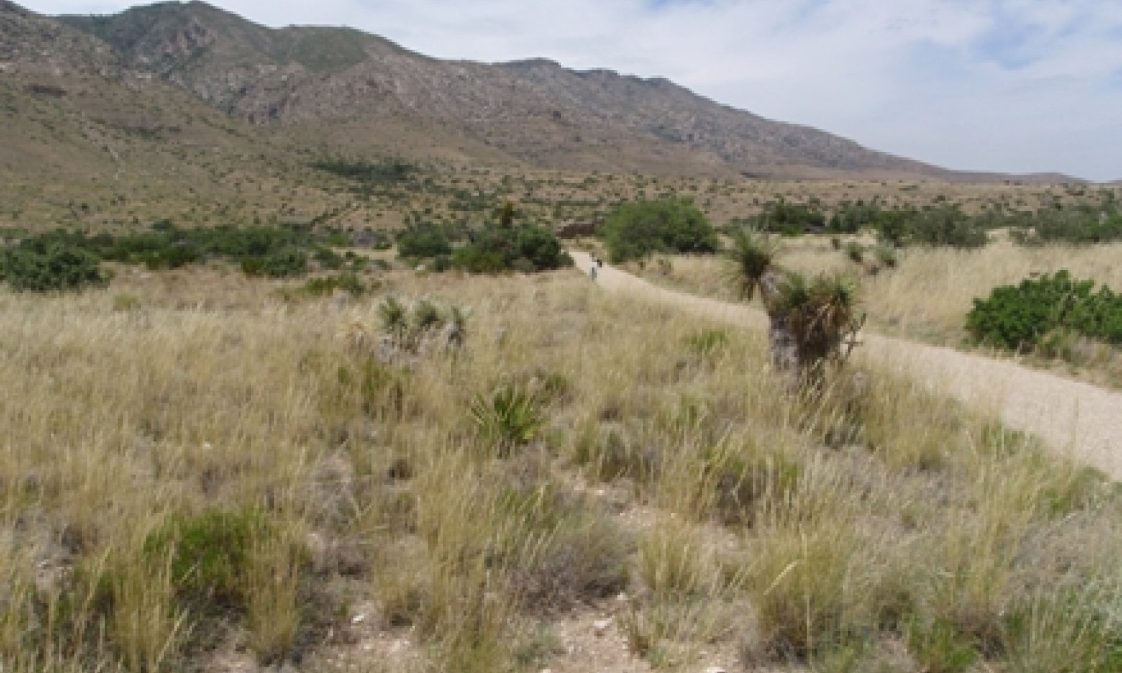
Figure 4. 1.1 Midgrass/Shrubs/Trees Community
This community phase is the reference plant community. Blue grama, sideoats grama, and black grama are common grasses. Common shrubs include redberry juniper, skunkbush sumac, wavyleaf oak, and sacahuista. Within this phase, cover of shrubs is approximately 25 percent or lower. Traces of trees such as pinyon pine, gray oak, and alligator juniper occur is some areas but are not characteristic throughout the entire range of the site. Annual production ranges from 850 to 1955 pounds per acre.
Conservation practices such as prescribed fire and/or prescribed grazing can help maintain this plant community with a diverse mix of species. Lack of any disturbance over time may favor more dominant plant life forms or particular species.
Figure 5. Annual production by plant type (representative values) or group (midpoint values)
Table 5. Annual production by plant type
Plant type Low
(lb/acre)Representative value
(lb/acre)High
(lb/acre)Grass/Grasslike 565 970 1360 Shrub/Vine 190 300 420 Forb 95 130 175 Total 850 1400 1955 Table 6. Ground cover
Tree foliar cover 0% Shrub/vine/liana foliar cover 10-10% Grass/grasslike foliar cover 20-30% Forb foliar cover 0-10% Non-vascular plants 0% Biological crusts 0% Litter 10-30% Surface fragments >0.25" and <=3" 20-50% Surface fragments >3" 10-10% Bedrock 0% Water 0% Bare ground 20-40% Figure 6. Plant community growth curve (percent production by month). NM4606 , R070DY156NM Gravelly Reference State. R070DY156NM Gravelly Reference State.
Jan Feb Mar Apr May Jun Jul Aug Sep Oct Nov Dec J F M A M J J A S O N D 0 0 3 8 7 10 25 25 15 5 2 0 Community 1.2
Cool-season Grasses/Shrubs/Trees Community
Figure 7. 1.2 Cool-season Grasses/Shrubs/Trees Community
New Mexico feathergrass, a cool-season grass dominates the herbaceous layer. Other cool-season grasses present in the plant community such as southwestern needlegrass may also increase. Warm-season grasses such as sideoats grama, black grama, and blue grama occur as subdominants.
Community 1.3
Threeawn/Shrubs/Trees CommunityThis plant community phase is the result of heavy continuous grazing. Less palatable grasses such as perennial threeawns and hairy grama are dominant. Cover of black and blue grama is very low (
Community 1.4
Juniper/Mixed-grass CommunityThis community phase is the result of fire suppression and/or heavy continuous grazing. Without fire (a natural succession to the landscape) will allow shrubs (specifically redberry juniper) to increase. Overgrazing can cause this transition as well since in can reduce the fine fuels needed to carry a fire. Depending on grazing pressure this community can either be dominated my increaser or decreaser grasses. There has been no evidence of an alternate stable state with very high canopy cover of juniper (>75 percent) and grasses are completely lost.
Catclaw mimosa can increase dramatically in very localized patches often in water receiving areas. Overgrazing can cause an initial increase by reducing herbaceous competition. When fine fuels return with prescribed grazing or no grazing these areas can readily burn. After fire, catclaw mimosa can increase dramatically and create extremely dense patches.
Conservation practices such as prescribed burning, brush management, prescribed grazing or no grazing can facilitate a transition back to a warm or cool season reference community with a relatively low cover of shrubs.
Pathway 1.1A
Community 1.1 to 1.2
Midgrass/Shrubs/Trees Community
Cool-season Grasses/Shrubs/Trees CommunityAbove average cool-season precipitation and rainfall events will cause a shift from a warm-season grass community to a cool-season dominated grass community.
Pathway 1.1B
Community 1.1 to 1.3Heavy continuous grazing or overutilization will decrease palatable grasses such as black grama and blue grama. Less palatable grasses, such as perennial threeawns and hairy grama increase.
Pathway 1.1C
Community 1.1 to 1.4The Midgrass/Shrubs/Trees Community will shift to the Juniper/Mixed-grass Community due to fire suppression, no brush management, and heavy continuous grazing.
Pathway 1.2A
Community 1.2 to 1.1
Cool-season Grasses/Shrubs/Trees Community
Midgrass/Shrubs/Trees CommunityAbove average warm-season precipitation will cause a shift from a cool-season grass community to a warm-season dominated grass community.
Pathway 1.2B
Community 1.2 to 1.3With heavy continuous grazing pressure and warm-season rainfall events, the Cool-season Grasses/Shrubs/Trees Community will shift to the Threeawn/Shrubs/Trees Community.
Pathway 1.2C
Community 1.2 to 1.4With fire suppression, no brush management, heavy continuous grazing, and warm-season rainfall events, the Cool-season Grasses/Shrubs/Trees Community will shift to the Juniper/Mixed-grass Community.
Pathway 1.3A
Community 1.3 to 1.1With Prescribed Burning or No Grazing Pressure and Warm-season rainfall events, the Threeawn/Shrubs/Trees Community will revert back to the Midgrass/Shrubs/Trees Community.
Conservation practices
Prescribed Grazing Pathway 1.3B
Community 1.3 to 1.2With Prescribed Grazing or No Grazing Pressure and Cool-season rainfall events, the Threeawn/Shrubs/Trees Community can revert back to the Cool-season Grasses/Shrubs/Trees Community.
Conservation practices
Prescribed Grazing Pathway 1.3C
Community 1.3 to 1.4The shift from the Threeawn/Shrubs/Trees Community to the Juniper/Mixed-grass Community occurs due to heavy continuous grazing, no fires, and no brush management.
Pathway 1.4B
Community 1.4 to 1.1With Prescribed Burning, Prescribed Grazing or no grazing pressure, Brush Management, and Warm-season rainfall events, the Juniper/Mixed-grass Community can revert back to the Midgrass/Shrubs/Trees Community.
Conservation practices
Brush Management Prescribed Burning Prescribed Grazing Pathway 1.4C
Community 1.4 to 1.2With Prescribed Burning, Prescribed Grazing or no grazing pressure, Brush Management, and Cool-season rainfall events, the Juniper/Mixed-grass Community can revert back to the Cool-season Grasses/Shrubs/Trees Community.
Conservation practices
Brush Management Prescribed Burning Prescribed Grazing Pathway 1.4A
Community 1.4 to 1.3With Prescribed Grazing or no grazing pressure, the Juniper/Mixed-grass Community can be reverted back to the Threeawn/Shrubs/Trees Community.
Conservation practices
Prescribed Grazing State 2
Introduced StateThis state is characterized by the introduction of nonnative species such as horehound (Marrubium vulgare). This plant was historically introduced as a plant for gardens and can be found in disturbed areas, pastures, and lawns. At Guadalupe Mountains National Park it does not dominate probably due to competition by natives. It is found in areas where livestock were historically concentrated such as old stock pens. Also growing where livestock were concentrated is western honey mesquite, a native shrub or small tree that is found in nearby associated ecological sites. It probably was not part of the historic reference community. Seeds were most likely introduced from other sites by livestock. Mesquite does provide plenty of value to wildlife. It will likely not spread without livestock grazing.
Horehound reproduces by seed and fire can kill adult plants (Weiss et al 2000). However, seeds of horehound will readily germinate after fire. Other control options include the use of chemicals or manual control.
Community 2.1
Grass/Shrub Complex Community
Figure 8. 2.1 Grass/Shrub Complex Community (1)

Figure 9. 2.1 Grass/Shrub Complex Community (2)
This state is characterized by the introduction of nonnative species such as horehound (Marrubium vulgare). This plant was historically introduced as a plant for gardens and can be found in disturbed areas, pastures, and lawns. At Guadalupe Mountains National Park, it does not dominate probably due to competition by natives. It is found in areas where livestock were historically concentrated such as old stock pens. Also growing where livestock were concentrated is western honey mesquite, a native shrub or small tree that is found in nearby associated ecological sites. It probably was not part of the historic reference community. Seeds were most likely introduced from other sites by livestock Mesquite does provide plenty of value to wildlife. It will likely not spread without livestock grazing.
Horehound reproduces by seed and fire can kill adult plants (Weiss et al 2000). However, seeds of horehound will readily germinate after fire. Other control options include the use of chemicals or manual control.
Transition T1A
State 1 to 2The transition from the Grassland/Shrubland State to the Introduced State occurs due to shrubs and weeds invasion and encroachment, heavy continuous grazing, no fires, and no brush management.
Restoration pathway R2A
State 2 to 1The Introduced State can be restored to the Grassland/Shrubland State through the implementation of various conservation practices including Prescribed or No grazing, Prescribed Burning, and Brush Management.
Conservation practices
Brush Management Prescribed Burning Prescribed Grazing Additional community tables
Table 7. Community 1.1 plant community composition
Group Common name Symbol Scientific name Annual production () Foliar cover (%) Grass/Grasslike1 Warm-season bunchgrasses 130–230 sideoats grama BOCU Bouteloua curtipendula 95–170 – blue grama BOGR2 Bouteloua gracilis 30–70 – 2 Warm-season stoloniferous 130–230 black grama BOER4 Bouteloua eriopoda 130–230 – 3 Warm-season bunchgrasses 60–180 cane bluestem BOBA3 Bothriochloa barbinodis 15–45 – plains lovegrass ERIN Eragrostis intermedia 15–45 – green sprangletop LEDU Leptochloa dubia 15–45 – little bluestem SCSC Schizachyrium scoparium 15–45 – 4 Warm-season bunchgrasses 100–290 sand dropseed SPCR Sporobolus cryptandrus 65–130 – common wolfstail LYPH Lycurus phleoides 10–40 – curlyleaf muhly MUSE Muhlenbergia setifolia 10–40 – Hall's panicgrass PAHA Panicum hallii 10–40 – streambed bristlegrass SELE6 Setaria leucopila 10–40 – 5 Warm-season bunchgrasses 95–250 slim tridens TRMU Tridens muticus 65–130 – threeawn ARIST Aristida 10–40 – hairy grama BOHI2 Bouteloua hirsuta 10–40 – hairy woollygrass ERPI5 Erioneuron pilosum 10–40 – 6 Cool-season bunchgrasses 30–120 southwestern needlegrass ACEM4 Achnatherum eminens 10–40 – squirreltail ELEL5 Elymus elymoides 10–40 – New Mexico feathergrass HENE5 Hesperostipa neomexicana 10–40 – 7 Other grasses 20–80 ring muhly MUTO2 Muhlenbergia torreyi 10–40 – burrograss SCBR2 Scleropogon brevifolius 10–40 – Shrub/Vine8 Fibrous/Succulents 50–140 soaptree yucca YUEL Yucca elata 30–65 – agave AGAVE Agave 10–35 – sotol DASYL Dasylirion 10–35 – sacahuista NOMI Nolina microcarpa 10–35 – hairy grama BOHI2 Bouteloua hirsuta 7–33 – squirreltail ELELE Elymus elymoides ssp. elymoides 7–33 – plains lovegrass ERIN Eragrostis intermedia 7–33 – common wolfstail LYPH Lycurus phleoides 7–33 – curlyleaf muhly MUSE Muhlenbergia setifolia 7–33 – Hall's panicgrass PAHA Panicum hallii 7–33 – tobosagrass PLMU3 Pleuraphis mutica 7–33 – little bluestem SCSC Schizachyrium scoparium 7–33 – plains bristlegrass SEVU2 Setaria vulpiseta 7–33 – pricklypear OPUNT Opuntia 5–20 – tree cholla CYIMI Cylindropuntia imbricata var. imbricata 5–20 – 9 Shrubs 60–160 catclaw mimosa MIACB Mimosa aculeaticarpa var. biuncifera 30–65 – fourwing saltbush ATCA2 Atriplex canescens 10–30 – Apache plume FAPA Fallugia paradoxa 10–30 – broom snakeweed GUSA2 Gutierrezia sarothrae 10–30 – winterfat KRLA2 Krascheninnikovia lanata 10–30 – 10 Shrubs 40–60 pungent oak QUPU Quercus pungens 20–40 – skunkbush sumac RHTR Rhus trilobata 20–40 – 11 Shrubs 40–60 yerba de pasmo BAPT Baccharis pteronioides 10–40 – alderleaf mountain mahogany CEMO2 Cercocarpus montanus 10–40 – javelina bush COER5 Condalia ericoides 10–40 – jointfir EPHED Ephedra 10–40 – crown of thorns KOSP Koeberlinia spinosa 10–40 – algerita MATR3 Mahonia trifoliolata 10–40 – mariola PAIN2 Parthenium incanum 10–40 – Pinchot's juniper JUPI Juniperus pinchotii 10–35 – Forb12 Forbs 95–175 yarrow ACHIL Achillea 20–35 – dwarf desertpeony ACNA2 Acourtia nana 20–35 – croton CROTO Croton 20–35 – fetid marigold DYPA Dyssodia papposa 20–35 – fleabane ERIGE2 Erigeron 20–35 – buckwheat ERIOG Eriogonum 10–35 – spurge EUPHO Euphorbia 20–35 – bladderpod LESQU Lesquerella 20–35 – beardtongue PENST Penstemon 20–35 – plantain PLANT Plantago 20–35 – woolly paperflower PSTA Psilostrophe tagetina 20–35 – senna SENNA Senna 20–35 – globemallow SPHAE Sphaeralcea 20–35 – verbena VEPO4 Verbena polystachya 20–35 – pricklyleaf dogweed THAC Thymophylla acerosa 10–25 – Table 8. Community 1.2 plant community composition
Group Common name Symbol Scientific name Annual production () Foliar cover (%) Table 9. Community 1.3 plant community composition
Group Common name Symbol Scientific name Annual production () Foliar cover (%) Table 10. Community 1.4 plant community composition
Group Common name Symbol Scientific name Annual production () Foliar cover (%) Table 11. Community 2.1 plant community composition
Group Common name Symbol Scientific name Annual production () Foliar cover (%) Interpretations
Supporting information
Inventory data references
Data collection for this site was done in conjunction with the progressive soil surveys within the Pecos-Canadian Plains and Valleys Major Land Resource Area of New Mexico (MLRA 70). This site has been mapped and correlated with soils in the following soil surveys: Otero, Eddy, Chaves, and Lincoln.
Other references
References:
1. Brown, J. R. and S. Archer. 1999. Shrub invasion of grassland: recruitment is continuous
And not regulated by herbaceous biomass or density. Ecology 80:2385-2396.
2. Johnsen, T. N., Jr. 1962. One-seeded juniper invasion of northern Arizona grasslands.
Ecological Monographs. 32:187-207.
3. Wright, H.A., and A.W. Bailey. 1982. Fire ecology: United States and southern
Canada. New York: John Wiley and Sons. 501p.
Contributors
David Trujillo
Don Sylvester
John Tunberg
Michael Margo, RMS, NRCS, Marfa, TexasApproval
Kendra Moseley, 10/21/2024
Rangeland health reference sheet
Interpreting Indicators of Rangeland Health is a qualitative assessment protocol used to determine ecosystem condition based on benchmark characteristics described in the Reference Sheet. A suite of 17 (or more) indicators are typically considered in an assessment. The ecological site(s) representative of an assessment location must be known prior to applying the protocol and must be verified based on soils and climate. Current plant community cannot be used to identify the ecological site.
Author(s)/participant(s) Contact for lead author Date 09/14/2026 Approved by Approval date Composition (Indicators 10 and 12) based on Annual Production Indicators
-
Number and extent of rills:
-
Presence of water flow patterns:
-
Number and height of erosional pedestals or terracettes:
-
Bare ground from Ecological Site Description or other studies (rock, litter, lichen, moss, plant canopy are not bare ground):
-
Number of gullies and erosion associated with gullies:
-
Extent of wind scoured, blowouts and/or depositional areas:
-
Amount of litter movement (describe size and distance expected to travel):
-
Soil surface (top few mm) resistance to erosion (stability values are averages - most sites will show a range of values):
-
Soil surface structure and SOM content (include type of structure and A-horizon color and thickness):
-
Effect of community phase composition (relative proportion of different functional groups) and spatial distribution on infiltration and runoff:
-
Presence and thickness of compaction layer (usually none; describe soil profile features which may be mistaken for compaction on this site):
-
Functional/Structural Groups (list in order of descending dominance by above-ground annual-production or live foliar cover using symbols: >>, >, = to indicate much greater than, greater than, and equal to):
Dominant:
Sub-dominant:
Other:
Additional:
-
Amount of plant mortality and decadence (include which functional groups are expected to show mortality or decadence):
-
Average percent litter cover (%) and depth ( in):
-
Expected annual annual-production (this is TOTAL above-ground annual-production, not just forage annual-production):
-
Potential invasive (including noxious) species (native and non-native). List species which BOTH characterize degraded states and have the potential to become a dominant or co-dominant species on the ecological site if their future establishment and growth is not actively controlled by management interventions. Species that become dominant for only one to several years (e.g., short-term response to drought or wildfire) are not invasive plants. Note that unlike other indicators, we are describing what is NOT expected in the reference state for the ecological site:
-
Perennial plant reproductive capability:
Print Options
Sections
Font
AAAAOther
PrintThe Ecosystem Dynamics Interpretive Tool is an information system framework developed by the USDA-ARS Jornada Experimental Range, USDA Natural Resources Conservation Service, and New Mexico State University.
Accessibility statement


