
Natural Resources
Conservation Service
-
Search


Major Land Resource Area or ecological site by name and/or ID.
PreviousSectionsNextGeneral information
Provisional. A provisional ecological site description has undergone quality control and quality assurance review. It contains a working state and transition model and enough information to identify the ecological site.
Click to explore map
Figure 1. Mapped extent
Areas shown in blue indicate the maximum mapped extent of this ecological site. Other ecological sites likely occur within the highlighted areas. It is also possible for this ecological site to occur outside of highlighted areas if detailed soil survey has not been completed or recently updated.
Associated sites
R042BB004NM Gyp Interdune (Wet), Desert Shrub
This site is intricately associated with the Gyp Interdune (wet) ecological site. They exist typically in a repeating pattern of dune/interdune. As the wind blows over the dune, it erodes the windward side and the sands moves up and over the crest and down the slipface. In this manner the dune migrates slowly across the associated interdune. The vegetation at the ecotones are in constant flux. Dune height and width between dunes affects the interdune erosion patterns and vegetation.
Table 1. Dominant plant species
Tree Not specified
Shrub Not specified
Herbaceous Not specified
Physiographic features
This site typically occurs on barchanoid type dunes. These include barchan, barchanoid ridge, and transverse ridge dunes. Barchan dunes are relatively small crescent shaped dunes with arms extending downwind. These dunes have a single slipface, the result of a predominant wind direction. In areas with an ample sand supply these barchan dunes can begin to coalesce forming a sinuous barchanoid ridge. If enough sand is present essentially straight ridges (Transverse) dunes can form. These dune types generally form in a sequence of diminishing sand supply--Transverse, Barchanoid ridge, and Barchan dunes.
Elevation ranges from about 3900 to 4200 feet.
Table 2. Representative physiographic features
Landforms (1) Barchan dune
(2) Transverse dune
Flooding frequency None Ponding frequency None Elevation 3900 – 4200 ft Slope 5 – 90 % Climatic features
Annual average precipitation ranges from 7 to 12 inches. Wide fluctuations from year to year are common. At least one-half of the annual precipitation comes in the form of rainfall during July, August, and September. Precipitation in the form of snow or sleet averages less than 4 inches annually. The average annual air temperature is about 60 degree F. Summer maximums can exceed 100 degrees F. and winter minimums can go below zero. The average frost-free season exceeds 200 days and extends from April 1 to November 1.
Climate data was obtained from
http://www.wrcc.dri.edu/summary/climsmnm.html
Table 3 Representative climatic features
Frost-free period (average) 210 days Freeze-free period (average) 230 days Precipitation total (average) 10 in BarLineFigure 2. Monthly precipitation range
BarLineFigure 3. Monthly average minimum and maximum temperature
">Influencing water features
Soil features
Soils of the dunes are highly gypsiferous sandy eolian deposits. They are excessively drained and display very rapid permeability. Slopes average 3-30 percent on the windward side of the dunes and 45-90 percent on the leeward side. Soils are moderately saline.
NM-688 MU-423 Duneland 5-90% slopes (Transverse ridge dunes)
NM-688 MU-426 Transformer-Duneland Assoc. 0-90% slopes (Barchan dunes)
NM-688 MU-427 Duneland-Transformer Assoc. 0-90% slopes (Barchan dunes)
Table 4. Representative soil features
Surface texture (1) Gypsiferous sand
Family particle size (1) Sandy
Drainage class Moderately well drained to excessively drained Permeability class Very rapid Soil depth 60 – 0 in Surface fragment cover <=3" Not specified Surface fragment cover >3" Not specified Available water capacity
(0-40in)2.5 – 3 in Electrical conductivity
(0-40in)7 – 12 mmhos/cm Subsurface fragment volume <=3"
(Depth not specified)Not specified Subsurface fragment volume >3"
(Depth not specified)Not specified Ecological dynamics
Overview:
Barchanoid dunes migrate downwind through the erosion of the windward face and the deposition of gypsiferous sands being blown over the dune crest and down the slipface of the dune. This constant migration of the dunes downwind creates an extremely harsh environment for vegetation to establish. The rapid rate of erosion and deposition prevents the establishment of most plants. The majority of the dunes are barren especially the transverse ridges and Barchanoid dunes, however, plants such as yucca, rosemary mint, skunkbush sumac, rabbitbrush, and various grasses are sometimes present along the advancing face of the dunes. In some instances individual saltcedar have successfully established on the dunes.
State and transition model
Custom diagramStandard diagram
More interactive model formats are also available. View Interactive Models
More interactive model formats are also available. View Interactive Models
Click on state and transition labels to scroll to the respective textEcosystem states
State 1 submodel, plant communities
State 2 submodel, plant communities
State 1
BareThis state is characterized by the general lack of vegetation.
Community 1.1
Barren
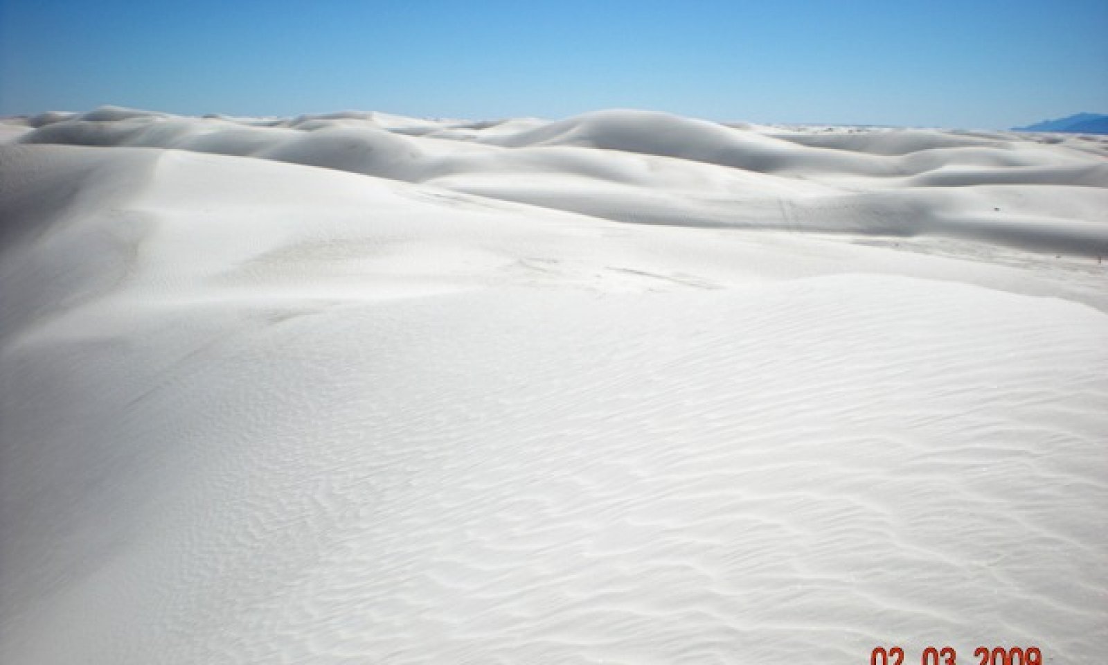
Figure 4. Gyp Duneland Barren
Dunes on this site are typically barren. This is believed to be due to high rates of erosion and deposition encountered across the dunes. This makes it extremely difficult for plants to establish on the dunes. Additionally the water table associated with these dunes is moderately to strongly saline.
Community 1.2
Isolated shrubs or grasses
Figure 5. Isolated Shrubs or grass

Figure 6. Plant pedestal

Figure 7. Plant burial
Occasionally plants do occur on the dunes. In some instances plants establish on the interdune and due to dune migration eventually become part of the advancing dune face. Or, relatively fast growing plants such as grasses and some shrubs can establish on the leeward side of the dune. In both instances the plants typically do not last long. Plants on the dunes are constantly undergoing deposition and most are eventually buried. Alternatively, in some instances plant capped pedestals can form where plants temporarily stabilize dune sediments and the surrounding sediments erode as the dune moves forward. The resulting pedestals remain and become part of the interdune until the plants die and the pedestal is eroded away.
Pathway 1.1A
Community 1.1 to 1.2
Barren
Isolated shrubs or grassesSeed dispersal and periods of favorable moisture may enable plants to establish on the dune surface. Plants must also possess rapid growth characteristics to enable them to grow faster than the burial rate.
Pathway 1.2A
Community 1.2 to 1.1
Isolated shrubs or grasses
BarrenBurial from dune advancement and erosion can easily destroy existing plants.
State 2
Exotic -InvadedThis state is characterized by the presence of saltcedar on the site.
Community 2.1
Saltcedar
Figure 8. Saltcedar Invaded
In some instances saltcedar is able to establish on these dunes. This may tend to occur during years when these sites experience unusually wet spring or early summer rains and the soil surface remains saturated for a few weeks. These periods of saturation provide moisture and dune stability necessary for plant establishment. Once established, saltcedar can grow very rapidly, attaining several feet in height during a single growing season. These plants are usually solitary individuals attesting to the harsh conditions of establishing among the dunes. Transitions to Exotic-Dominated seem unlikely. Occasionally, pedestals capped by saltcedar can form when the saltcedar temporarily stabilizes dune sediments and the surrounding sediments erode as the dune advances.
Transition T1A
State 1 to 2Transitions to the Exotic-Invaded state are believed to occur in response to the introduction of seed from surrounding areas and periods of favorable rainfall. These wet periods help the dune surface sands to temporarily stabilize and remain wet long enough to allow seed germination and establishment. Additionally, surface moisture via capallary rise may assist with water requirements for seed germination. Once established seedlings can grow very quickly.
Restoration pathway R2A
State 2 to 1Chemical treatment (individual plant), follow-up, and monitoring is recommended to ensure kill and prevent further seed production and dispersal.
Additional community tables
Table 5. Community 1.1 plant community composition
Group Common name Symbol Scientific name Annual production () Foliar cover (%) Table 6. Community 1.2 plant community composition
Group Common name Symbol Scientific name Annual production () Foliar cover (%) Table 7. Community 2.1 plant community composition
Group Common name Symbol Scientific name Annual production () Foliar cover (%) Interpretations
Animal community
Characteristic wildlife includes little striped whiptail, White Sands prairie lizard, bleached earless lizard, spadefoot toad, Apache pocket mouse, White sands woodrat, spotted ground squirrel, camel cricket, tiger beetle, lycosid spider, and scorpions. Ord’s kangaroo rat and spotted ground squirrel.
Recreational uses
Gypsum dunes are used extensively for recreation and education on White Sands National Momument. Dunes on White Sands Missile Range have been utilized for numerous movie sets.
Wood products
There are no wood products associated with this site.
Other products
Gypsum
Supporting information
Other references
Fryberger, S. G. 2003. Geology of White Sands National Monument. Web page www.nature.nps.gov/geology/parks/whsa/geows/index.htm
E. McKee, An introduction to the study of global sand seas, in: McKee (Ed.), A Study of Global Sand Seas, 1979, pp. 1–20.
Langford, R. P., Rose, J. M., White, D.E. 2009. Groundwater salinity as a control on development of eolian landscape: An example from the White Sands of New Mexico. Geomorphology 105 (2009) pp. 39–49.
Di Tomaso, J. M., 1998. Impact, Biology, and Ecology of Saltcedar (Tamarix spp.) in the Southwestern United States. Weed Technology (12) pp. 326-336.
Contributors
David Trujillo
Rangeland health reference sheet
Interpreting Indicators of Rangeland Health is a qualitative assessment protocol used to determine ecosystem condition based on benchmark characteristics described in the Reference Sheet. A suite of 17 (or more) indicators are typically considered in an assessment. The ecological site(s) representative of an assessment location must be known prior to applying the protocol and must be verified based on soils and climate. Current plant community cannot be used to identify the ecological site.
Author(s)/participant(s) Contact for lead author Date Approved by Approval date Composition (Indicators 10 and 12) based on Annual Production Indicators
-
Number and extent of rills:
-
Presence of water flow patterns:
-
Number and height of erosional pedestals or terracettes:
-
Bare ground from Ecological Site Description or other studies (rock, litter, lichen, moss, plant canopy are not bare ground):
-
Number of gullies and erosion associated with gullies:
-
Extent of wind scoured, blowouts and/or depositional areas:
-
Amount of litter movement (describe size and distance expected to travel):
-
Soil surface (top few mm) resistance to erosion (stability values are averages - most sites will show a range of values):
-
Soil surface structure and SOM content (include type of structure and A-horizon color and thickness):
-
Effect of community phase composition (relative proportion of different functional groups) and spatial distribution on infiltration and runoff:
-
Presence and thickness of compaction layer (usually none; describe soil profile features which may be mistaken for compaction on this site):
-
Functional/Structural Groups (list in order of descending dominance by above-ground annual-production or live foliar cover using symbols: >>, >, = to indicate much greater than, greater than, and equal to):
Dominant:
Sub-dominant:
Other:
Additional:
-
Amount of plant mortality and decadence (include which functional groups are expected to show mortality or decadence):
-
Average percent litter cover (%) and depth ( in):
-
Expected annual annual-production (this is TOTAL above-ground annual-production, not just forage annual-production):
-
Potential invasive (including noxious) species (native and non-native). List species which BOTH characterize degraded states and have the potential to become a dominant or co-dominant species on the ecological site if their future establishment and growth is not actively controlled by management interventions. Species that become dominant for only one to several years (e.g., short-term response to drought or wildfire) are not invasive plants. Note that unlike other indicators, we are describing what is NOT expected in the reference state for the ecological site:
-
Perennial plant reproductive capability:
Print Options
Sections
Font
AAAAOther
PrintThe Ecosystem Dynamics Interpretive Tool is an information system framework developed by the USDA-ARS Jornada Experimental Range, USDA Natural Resources Conservation Service, and New Mexico State University.
Accessibility statement


