Natural Resources
Conservation Service
Ecological site R042AB737TX
Limestone Hill and Mountain,
Hot Desert Shrub
Accessed: 07/11/2026
-
Search


Major Land Resource Area or ecological site by name and/or ID.
PreviousSectionsNextGeneral information
Provisional. A provisional ecological site description has undergone quality control and quality assurance review. It contains a working state and transition model and enough information to identify the ecological site.
Click to explore map
Figure 1. Mapped extent
Areas shown in blue indicate the maximum mapped extent of this ecological site. Other ecological sites likely occur within the highlighted areas. It is also possible for this ecological site to occur outside of highlighted areas if detailed soil survey has not been completed or recently updated.
Classification relationships
International Vegetation Classification:
Bouteloua ramosa Herbaceous Vegetation
Unique Identifier: CEGL004522
Associated sites
R042AB264TX Igneous Hill and Mountain, Hot Desert Shrub
Depending on geology, the Igneous Hill & Mountain site can be associated within the same mountain range.
R042AB735TX Gravelly, Hot Desert Shrub
The Gravelly, Hot Desert Shrub site occurs on alluvial fans below the Limestone Hill and Mountain ecological site.
Similar sites
R042AB264TX Igneous Hill and Mountain, Hot Desert Shrub
The Igneous Hill and Mountain Hot Desert Shrub site is similar but is formed from igneous parent material instead of limestone parent material, thereby affection species composition and production.
Table 1. Dominant plant species
Tree Not specified
Shrub Not specified
Herbaceous Not specified
Physiographic features
The site occurs on limestone hills and mountains (Quitman and Indio Mountains in Hudspeth County, TX) at elevations of 3000 to 4000 feet. Slopes range from 5 to 65 percent. Surface runoff is low to medium on 5 to 10 percent slopes, medium on 10 to 20 percent slopes and high on 20 to 65 percent slopes. Aspect will influence species composition and production.

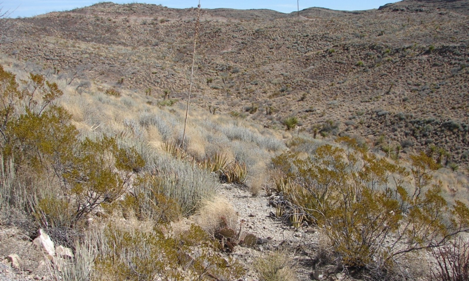
Figure 2. Typical pattern of Redlight and associated soils
Table 2. Representative physiographic features
Landforms (1) Hill
(2) Mountain
Flooding frequency None Ponding frequency None Elevation 3000 – 4000 ft Slope 5 – 65 % Aspect N, S Climatic features
The average annual precipitation ranges from 10 to 12 inches. Most of the precipitation occurs as widely scattered thunderstorms of high intensity and short duration during the summer. Occasional precipitation occurs as light rainfall during the cool season. Negligible amounts of precipitation falls in the form of sleet or snow.
Mean annual air temperature is 70° F. Daytime temperatures exceeding 100° F are common from May through September. Frost free period ranges from 254 to 295 days.
The average relative humidity in mid-afternoon is about 25 percent. Relative humidity is higher at night, and the average at dawn is about 57 percent. The sun shines 81 percent of the time in summer and 75 percent in winter. The prevailing wind is from the southwest. Average wind speed is highest, around 11 miles per hour, in March and April.
The combination of low rainfall and relative humidity, warm temperatures, and high solar radiation creates a significant moisture deficit. The annual Class-A pan evaporation is approximately 94 inches.
Table 3 Representative climatic features
Frost-free period (average) 300 days Freeze-free period (average) 330 days Precipitation total (average) 10 in BarLineFigure 3. Monthly precipitation range
BarLineFigure 4. Monthly average minimum and maximum temperature
">Influencing water features
N/A
Soil features
This ecological site consists of soils that are very shallow or shallow to limestone bedrock. These soils formed in residuum and colluvium derived from thick beds of Cretaceous limestone. Depths to bedrock range from 6 to 20 inches. Soil textures include coarse sandy loam, sandy loam, and loam with limestone surface and subsurface fragments ranging from 30 to 70 percent. Textural modifiers include very gravelly and extremely cobbly. Soils are well drained and moderately permeable over very slowly permeable limestone bedrock. The soils are classified as hyperthermic, meaning that the Mean Annual Soil Temperature at a depth of 20 inches or to bedrock is 72 to 78 degrees Farenheit. The Limestone Hill and Mountain, Hot Desert Shrub ecological site is correlated to the Redlight soil component in the following two map units:
Redlight and Terlingua soils and Rock outcrop, 5 to 35 percent slopes.
Redlight and Terlingua soils and Rock outcrop, 35 to 65 percent slopes.
Table 4. Representative soil features
Parent material (1) Residuum – limestone
Surface texture (1) Very gravelly coarse sandy loam
(2) Extremely cobbly sandy loam
(3) Very gravelly loam
Family particle size (1) Loamy
Drainage class Well drained Permeability class Very slow Soil depth 6 – 20 in Surface fragment cover <=3" 20 – 45 % Surface fragment cover >3" 10 – 25 % Available water capacity
(0-40in)0 – 1 in Calcium carbonate equivalent
(0-40in)10 – 40 % Electrical conductivity
(0-40in)0 – 1 mmhos/cm Sodium adsorption ratio
(0-40in)Not specified Soil reaction (1:1 water)
(0-40in)7.9 – 8.4 Subsurface fragment volume <=3"
(Depth not specified)30 – 40 % Subsurface fragment volume >3"
(Depth not specified)5 – 20 % Ecological dynamics
State and transition model
Custom diagramStandard diagram
More interactive model formats are also available. View Interactive Models
More interactive model formats are also available. View Interactive Models
Click on state and transition labels to scroll to the respective textEcosystem states
State 1 submodel, plant communities
State 1
Grass/Shrub StateCommunity 1.1
Chino grama / mixed shrubs
Figure 5. Chino grama / mixed shrubs

Figure 6. Chino grama / mixed shrubs

Figure 7. Chino grama / mixed shrubs

Figure 8. Chino grama / mixed shrubs
Figure 9. Annual production by plant type (representative values) or group (midpoint values)
Table 5. Annual production by plant type
Plant type Low
(lb/acre)Representative value
(lb/acre)High
(lb/acre)Grass/Grasslike 245 315 385 Shrub/Vine 87 112 137 Forb 18 23 28 Total 350 450 550 Table 6. Ground cover
Tree foliar cover 0% Shrub/vine/liana foliar cover 10-30% Grass/grasslike foliar cover 20-40% Forb foliar cover 0-10% Non-vascular plants 0% Biological crusts 0% Litter 20-30% Surface fragments >0.25" and <=3" 20-50% Surface fragments >3" 10-30% Bedrock 0% Water 0% Bare ground 0% Table 7. Soil surface cover
Tree basal cover 0% Shrub/vine/liana basal cover 0-0% Grass/grasslike basal cover 0-10% Forb basal cover 0-0% Non-vascular plants 0% Biological crusts 0% Litter 20-30% Surface fragments >0.25" and <=3" 20-50% Surface fragments >3" 10-30% Bedrock 0% Water 0% Bare ground 0-10% Table 8. Canopy structure (% cover)
Height Above Ground (ft) Tree Shrub/Vine Grass/
GrasslikeForb <0.5 – 1-3% 1-5% 1-3% >0.5 <= 1 – 2-5% 13-25% 0-2% >1 <= 2 – 5-10% 1-5% – >2 <= 4.5 – 1-4% – – >4.5 <= 13 – 1-3% – – >13 <= 40 – – – – >40 <= 80 – – – – >80 <= 120 – – – – >120 – – – – Figure 10. Plant community growth curve (percent production by month). TX0011 , Grassland/Shrub Community. Grass Dominant with Shrubs Community..
Jan Feb Mar Apr May Jun Jul Aug Sep Oct Nov Dec J F M A M J J A S O N D 0 0 0 5 5 10 15 25 25 10 5 0 Community 1.2
Fluffgrass - Chino grama / mixed shrubs
Figure 11. Fluff grass - Chino grama / mixed shrubs
Pathway 1.1A
Community 1.1 to 1.2
Chino grama / mixed shrubs
Fluffgrass - Chino grama / mixed shrubsExamples of management actions that would reduce herbaceous cover include livestock overgrazing, disturbances along road development, and the harvesting of Chino grama (a practice not seen today).
Pathway 1.2A
Community 1.2 to 1.1
Fluffgrass - Chino grama / mixed shrubs
Chino grama / mixed shrubsManagement actions that would increase herbaceous plant cover would be prescribed or a planned grazing system that includes deferment and favorable rainfall to allow recovery of grasses.
Conservation practices
Prescribed Grazing Additional community tables
Table 9. Community 1.1 plant community composition
Group Common name Symbol Scientific name Annual production () Foliar cover (%) Grass/Grasslike1 Dominant bunchgrass 160–240 Chino grama BORA4 Bouteloua ramosa 160–240 – 2 Subdominant bunchgrasses 50–85 sideoats grama BOCU Bouteloua curtipendula 15–50 – Arizona cottontop DICA8 Digitaria californica 15–50 – slim tridens TRMU Tridens muticus 10–20 – nineawn pappusgrass ENDE Enneapogon desvauxii 5–15 – purple threeawn ARPU9 Aristida purpurea 5–15 – Hall's panicgrass PAHA Panicum hallii 5–15 – hairy woollygrass ERPI5 Erioneuron pilosum 3–10 – 3 Stoloniferous 35–60 black grama BOER4 Bouteloua eriopoda 30–50 – false grama CAER2 Cathestecum erectum 0–10 – low woollygrass DAPU7 Dasyochloa pulchella 5–10 – Forb4 Perennial forbs 15–25 Forb, perennial 2FP Forb, perennial 5–10 – croton CROTO Croton 5–10 – beeblossom GAURA Gaura 1–5 – menodora MENOD Menodora 1–5 – globemallow SPHAE Sphaeralcea 1–5 – zinnia ZINNI Zinnia 1–5 – pricklyleaf dogweed THAC Thymophylla acerosa 1–3 – 5 Annual forbs 0–5 Forb, annual 2FA Forb, annual 0–5 – bladderpod LESQU Lesquerella 0–1 – Shrub/Vine6 Shrubs 52–67 creosote bush LATR2 Larrea tridentata 15–30 – desert myrtlecroton BEOB Bernardia obovata 10–25 – rough jointfir EPAS Ephedra aspera 10–25 – ocotillo FOSP2 Fouquieria splendens 10–25 – Big Bend barometerbush LEMI4 Leucophyllum minus 5–15 – mariola PAIN2 Parthenium incanum 5–15 – western honey mesquite PRGLT Prosopis glandulosa var. torreyana 0–10 – whitethorn acacia ACCO2 Acacia constricta 5–10 – 7 Subshrub 15–30 plumed crinklemat TIGR Tiquilia greggii 5–15 – littleleaf ratany KRER Krameria erecta 5–15 – featherplume DAFO Dalea formosa 3–10 – woody crinklemat TICAC Tiquilia canescens var. canescens 2–7 – 8 Succulent/fibrous 20–40 Torrey's yucca YUTO Yucca torreyi 5–30 – lechuguilla AGLE Agave lechuguilla 5–30 – tree cholla CYIMI Cylindropuntia imbricata var. imbricata 5–30 – green sotol DALE2 Dasylirion leiophyllum 5–30 – candelilla EUAN3 Euphorbia antisyphilitica 5–30 – leatherstem JADI Jatropha dioica 5–15 – blind pricklypear OPRU3 Opuntia rufida 5–15 – pricklypear OPUNT Opuntia 5–15 – spiny hedgehog cactus ECDA Echinocereus dasyacanthus 1–3 – Table 10. Community 1.2 plant community composition
Group Common name Symbol Scientific name Annual production () Foliar cover (%) Interpretations
Recreational uses
Hiking and mule deer hunting are popular recreational uses.
Wood products
N/A
Other products
N/A
Supporting information
Contributors
Michael Margo
Michael Margo, RMS, NRCS, Marfa, TX
NRCS UnknownRangeland health reference sheet
Interpreting Indicators of Rangeland Health is a qualitative assessment protocol used to determine ecosystem condition based on benchmark characteristics described in the Reference Sheet. A suite of 17 (or more) indicators are typically considered in an assessment. The ecological site(s) representative of an assessment location must be known prior to applying the protocol and must be verified based on soils and climate. Current plant community cannot be used to identify the ecological site.
Author(s)/participant(s) Michael Margo, RMS, NRCS, Marfa, TX Contact for lead author Zone RMS, San Angelo, TX 325-944-0147 Date 04/16/2012 Approved by Approval date Composition (Indicators 10 and 12) based on Annual Production Indicators
-
Number and extent of rills:
None -
Presence of water flow patterns:
None, except following high intesity storms, when short (less than 1 m) and discontinuous flow patterns may appear. Flow patterns in drainages are linear and continuous. -
Number and height of erosional pedestals or terracettes:
None -
Bare ground from Ecological Site Description or other studies (rock, litter, lichen, moss, plant canopy are not bare ground):
2-5% bare ground -
Number of gullies and erosion associated with gullies:
None -
Extent of wind scoured, blowouts and/or depositional areas:
None -
Amount of litter movement (describe size and distance expected to travel):
In drainages, there can be significant amounts of litter moved long distances. On most of the site, minimal and short distance (<5ft) of litter movement associated with high intense rainfall. -
Soil surface (top few mm) resistance to erosion (stability values are averages - most sites will show a range of values):
Soil stability values usually ranging from 4-6 under vegetation and 2-3 in the interspaces -
Soil surface structure and SOM content (include type of structure and A-horizon color and thickness):
Up to 7 inches thick, pale brown surface horizon with a weak fine granular structure. Data from Redlight soil series description. -
Effect of community phase composition (relative proportion of different functional groups) and spatial distribution on infiltration and runoff:
A high canopy cover of midgrass bunch and stoliniferous grasses will help minimize runoff and maximize infiltration. Grasses should comprise approximately 75% of total plant compostion by weight. Shrubs and forbs will comprise about 15% and 10%, respectively, by weight. -
Presence and thickness of compaction layer (usually none; describe soil profile features which may be mistaken for compaction on this site):
None -
Functional/Structural Groups (list in order of descending dominance by above-ground annual-production or live foliar cover using symbols: >>, >, = to indicate much greater than, greater than, and equal to):
Dominant:
Mid bunchgrass (Chino grama)Sub-dominant:
Short stoloniferous grasses > shrubsOther:
Mid/short bunchgrasses > fibrous/succulents = perennial forbs > annual forbs/grassesAdditional:
-
Amount of plant mortality and decadence (include which functional groups are expected to show mortality or decadence):
All grasses will show some mortality and decadence in addition to annual forbs. Mid/tall perennial shrubs will show some mortality or decadence only after prolonged and severe droughts. Subshrubs will be less resistant to severe droughts than mid/tall perennial shrubs. -
Average percent litter cover (%) and depth ( in):
-
Expected annual annual-production (this is TOTAL above-ground annual-production, not just forage annual-production):
350-550 lbs/ac -
Potential invasive (including noxious) species (native and non-native). List species which BOTH characterize degraded states and have the potential to become a dominant or co-dominant species on the ecological site if their future establishment and growth is not actively controlled by management interventions. Species that become dominant for only one to several years (e.g., short-term response to drought or wildfire) are not invasive plants. Note that unlike other indicators, we are describing what is NOT expected in the reference state for the ecological site:
None -
Perennial plant reproductive capability:
All species should be capable of reproducing.
Print Options
Sections
Font
AAAAOther
PrintThe Ecosystem Dynamics Interpretive Tool is an information system framework developed by the USDA-ARS Jornada Experimental Range, USDA Natural Resources Conservation Service, and New Mexico State University.
Accessibility statement