
Natural Resources
Conservation Service
-
Search


Major Land Resource Area or ecological site by name and/or ID.
PreviousSectionsNextGeneral information
Provisional. A provisional ecological site description has undergone quality control and quality assurance review. It contains a working state and transition model and enough information to identify the ecological site.
Click to explore map
Figure 1. Mapped extent
Areas shown in blue indicate the maximum mapped extent of this ecological site. Other ecological sites likely occur within the highlighted areas. It is also possible for this ecological site to occur outside of highlighted areas if detailed soil survey has not been completed or recently updated.
MLRA notes
Major Land Resource Area (MLRA): 041X–Madrean Archipelago
AZ 41.2 – Chihuahuan – Sonoran Desert Shrubs
Elevations range from 2600 to 4000 feet and precipitation ranges from 8 to 12 inches per year. Vegetation includes mesquite, palo verde, catclaw acacia, soaptree yucca, creosotebush, whitethorn, staghorn cholla, desert saltbush, Mormon tea, burroweed, snakeweed, tobosa, black grama, threeawns, bush muhly, dropseed, and burrograss. The soil temperature regime is thermic and the soil moisture regime is typic aridic. This unit occurs within the Basin and Range Physiographic Province and is characterized by numerous mountain ranges that rise abruptly from broad, plain-like valleys and basins. Igneous and metamorphic rock classes dominate the mountain ranges and sediments filling the basins represent combinations of fluvial, lacustrine, colluvial and alluvial deposits.Associated sites
R041XB203AZ Clayey Upland 8-12" p.z.
R041XB208AZ Limy Upland 8-12" p.z.
R041XB220AZ Limestone Hills 8-12" p.z.
R041XC330AZ Volcanic Hills 12-16" p.z. Clayey
Similar sites
R040XA101AZ Basalt Hills 10"-13" p.z.
R041XC323AZ Volcanic Hills 12-16" p.z. Loamy
R038XA133AZ Volcanic/Metamorphic Hills 12-16" p.z.
Table 1. Dominant plant species
Tree Not specified
Shrub (1) larrea tridentata
(2) acaciaHerbaceous (1) bouteloua eriopoda
(2) muhlenbergia porteriPhysiographic features
This site occurs in the lowest elevations of the Madrean Basin and Range province in southeastern Arizona. It occurs on hill-slopes, ridge-tops and mesas.
Table 2. Representative physiographic features
Landforms (1) Hill
(2) Ridge
(3) Mesa
Flooding frequency None Ponding frequency None Elevation 2600 – 4000 ft Slope 15 – 65 % Aspect N, E, S Climatic features
Precipitation ranges from 8-12 inches annually. More than half falls during July-Sep in brief, but often heavy, thunderstorms. The rest of the moisture comes as light rain or snow that falls slowly for a day or more, but rarely lasts more than a day. May and June are normally the driest months. Humidity is generally very low.
Temperatures are mild throughout most of the year. Freezing temperatures are common at night Dec-Feb; brief 0 F may be observed some nights. During June, July & August, some days may exceed 100 F.
In years of average or greater winter precipitation, annual grasses and forbs occur abundantly in the interspaces.Table 3 Representative climatic features
Frost-free period (average) 240 days Freeze-free period (average) 0 days Precipitation total (average) 0 in BarLineFigure 2. Monthly precipitation range
BarLineFigure 3. Monthly average minimum and maximum temperature
">Influencing water features
There are no water features associated with this site.
Soil features
These are shallow, calcareous, loamy soils on basic igneous bedrock like basalt, andesite and related tuffs, agglomerates and welded ash. Bedrock is hard and un-weathered. Soils are very gravelly and cobbly in the profile. They have well developed covers of gravels and cobbles. Plant soil-moisture relationships are fair.
Soils mapped to date on this site include: SSA-662 Safford area MU's GuE Graham and Rk rockland; SSA-663 Gila-Duncan area MU 1 Akela & Lehmans.Table 4. Representative soil features
Parent material (1) Colluvium – andesite
Surface texture (1) Very cobbly sandy loam
(2) Very gravelly sandy loam
(3) Cobbly loam
Family particle size (1) Loamy
Drainage class Well drained Permeability class Moderately rapid to moderate Soil depth 5 – 20 in Surface fragment cover <=3" 40 – 60 % Surface fragment cover >3" 20 – 40 % Available water capacity
(0-40in)0.6 – 2.3 in Calcium carbonate equivalent
(0-40in)3 – 15 % Electrical conductivity
(0-40in)0 – 2 mmhos/cm Sodium adsorption ratio
(0-40in)0 – 2 Soil reaction (1:1 water)
(0-40in)7.4 – 8.4 Subsurface fragment volume <=3"
(Depth not specified)35 – 65 % Subsurface fragment volume >3"
(Depth not specified)5 – 30 % Ecological dynamics
The plant communities found on an ecological site are naturally variable. Composition and production will vary with yearly conditions, location, aspect and the natural variability of the soils. The Historical Climax Plant Community represents the natural potential plant community found on relict or relatively undisturbed areas of this site. Other plant communities described here represent plant communities that are known to occur when the site is disturbed by factors such as fire, grazing and drought.
Production data provided in this site description is standardized to air dry weight at the end of the summer growing season. The plant communities described in this site description are based on near normal rainfall years.
NRCS uses a Similarity Index to compare existing plant communities to the plant communities described here. Similarity index is determined by comparing the production and composition of a plant community to the production and composition described in the site description. To determine similarity index, compare the production (air dry weight) of each species to that shown in the plant community description. For each species, count no more than the maximum amount shown for the species, and for each group, count no more than the amount shown for that group. Divide the resulting total by the total, normal year, production shown in the plant community description. If the rainfall has been significantly above or below normal, use the total production shown for above or below normal years. If the field data is not collected at the end of the summer growing season, then the field data must be corrected to the end of year production before comparing it to the site description. The growth curve can be used as a guide for estimating production at the end of the summer growing season.
The historic native state includes the native plant communities that occur on the site, including the historic climax plant community. This state includes other plant communities that naturally occupy the site following fire, drought, flooding, herbivores and other natural disturbances. The historic climax plant community represents the natural climax community that eventually reoccupies the site with proper management and a return to near normal conditions and/or equilibrium.
State and transition model
More interactive model formats are also available. View Interactive Models
Click on state and transition labels to scroll to the respective textEcosystem states
State 1 submodel, plant communities
State 2 submodel, plant communities
State 3 submodel, plant communities
State 1
HCPCCommunity 1.1
HCPC
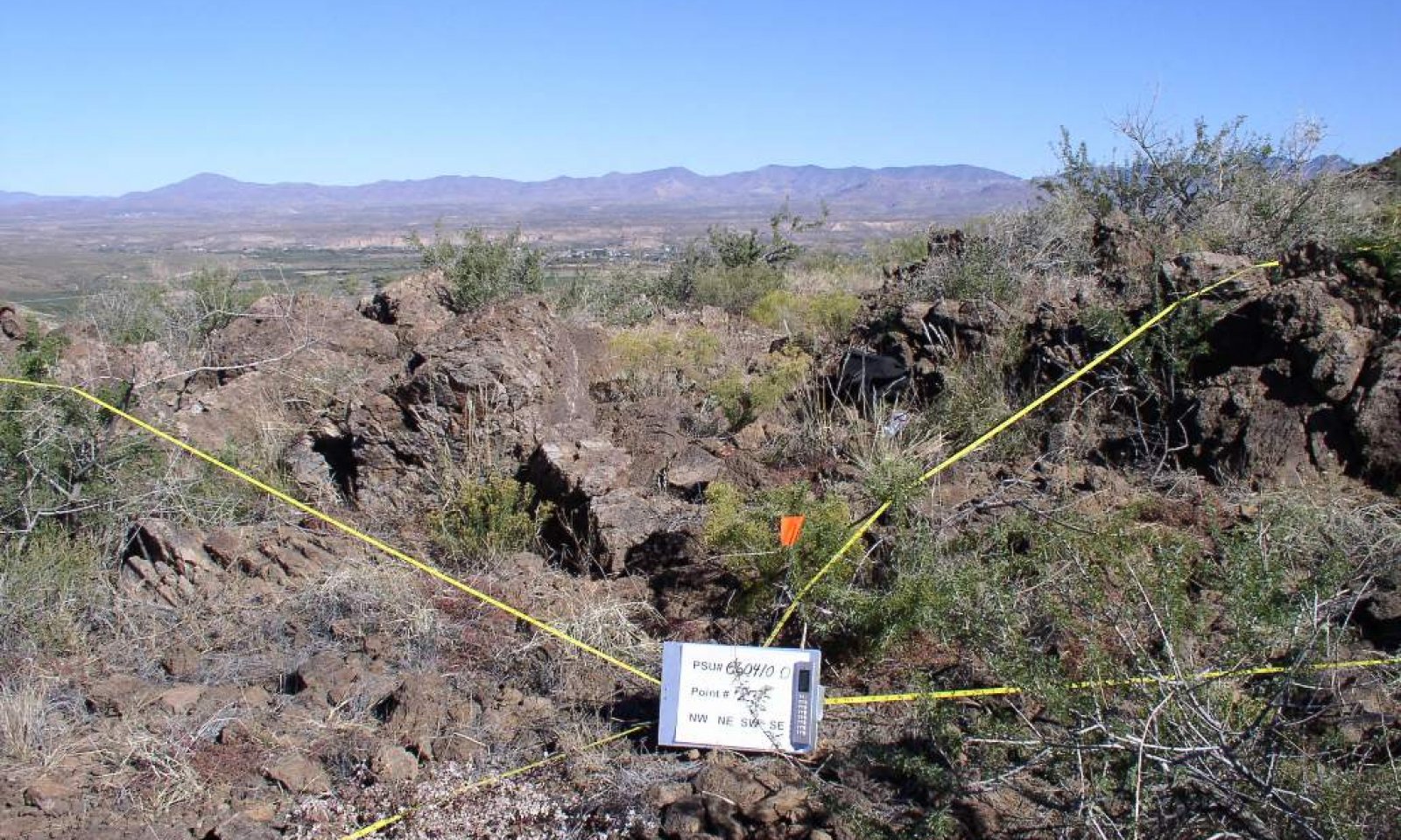
Figure 4. Basalt Hills 8-12" pz., HCPC
The native potential plant community on this site is a mixture of desert trees, shrubs, succulents and perennial and annual forbs and grasses. Shrubs like creosote bush dominate the plant community. Annuals, of both winter and summer types, are very important in their respective seasons in wet years. Perennial grasses fluctuate from 1-2% after prolonged drought to 20% of the plant community during favorable rainfall years.
Figure 5. Annual production by plant type (representative values) or group (midpoint values)
Table 5. Annual production by plant type
Plant type Low
(lb/acre)Representative value
(lb/acre)High
(lb/acre)Shrub/Vine 71 200 315 Grass/Grasslike 17 50 240 Forb 4 20 180 Tree 0 1 20 Total 92 271 755 Table 6. Soil surface cover
Tree basal cover 0% Shrub/vine/liana basal cover 0-0% Grass/grasslike basal cover 0-0% Forb basal cover 0-0% Non-vascular plants 0% Biological crusts 0-10% Litter 10-60% Surface fragments >0.25" and <=3" 40-60% Surface fragments >3" 20-40% Bedrock 0-10% Water 0% Bare ground 10-30% Table 7. Canopy structure (% cover)
Height Above Ground (ft) Tree Shrub/Vine Grass/
GrasslikeForb <0.5 – 0-1% 1-20% 0-15% >0.5 <= 1 – 1-5% 1-10% 1-10% >1 <= 2 – 1-10% 2-5% 1-10% >2 <= 4.5 – 5-15% 0-1% 0-1% >4.5 <= 13 0-1% 1-5% – – >13 <= 40 0-1% – – – >40 <= 80 – – – – >80 <= 120 – – – – >120 – – – – State 2
Shrubs, exotic annualsCommunity 2.1
Shrubs, exotic annuals
Figure 6. Basalt Hills 8-12" pz., red brome
This state occurs where non-native annual grasses and forbs have increased to dominate the herbaceous layer of the plant community. The native tree and shrub cover is intact. Annual species like red brome, cheatgrass, filaree, purslane and tumble mustard dominate the under-story. Native annuals and perennial grasses and forbs still exist in the plant community but are diminished in cover and diversity.
State 3
AnnualsCommunity 3.1
Annuals
Figure 7. Basalt Hills 8-12" pz., repeated fires
This state occurs where repeated fires have removed the tree and shrub component of the plant community. It occurs near residential areas and along heavily traveled roads where the incidence of fire is high. Native and non-native annual forbs and grasses dominate the plant community.
Additional community tables
Table 8. Community 1.1 plant community composition
Group Common name Symbol Scientific name Annual production () Foliar cover (%) Grass/Grasslike1 Dominant perennial grasses 15–100 sideoats grama BOCU Bouteloua curtipendula 5–50 – black grama BOER4 Bouteloua eriopoda 5–50 – bush muhly MUPO2 Muhlenbergia porteri 5–50 – tobosagrass PLMU3 Pleuraphis mutica 5–30 – slim tridens TRMU Tridens muticus 0–30 – purple threeawn ARPU9 Aristida purpurea 0–20 – blue threeawn ARPUN Aristida purpurea var. nealleyi 0–20 – Parish's threeawn ARPUP5 Aristida purpurea var. parishii 0–20 – spidergrass ARTE3 Aristida ternipes 0–15 – spidergrass ARTEG Aristida ternipes var. gentilis 0–10 – 2 Misc. perennial grasses 1–30 low woollygrass DAPU7 Dasyochloa pulchella 1–10 – Arizona cottontop DICA8 Digitaria californica 0–10 – tanglehead HECO10 Heteropogon contortus 0–10 – Hall's panicgrass PAHA Panicum hallii 0–10 – plains bristlegrass SEVU2 Setaria vulpiseta 0–10 – nineawn pappusgrass ENDE Enneapogon desvauxii 1–5 – sand dropseed SPCR Sporobolus cryptandrus 0–5 – slim tridens TRMUE Tridens muticus var. elongatus 0–1 – burrograss SCBR2 Scleropogon brevifolius 0–1 – fall witchgrass DICO6 Digitaria cognata 0–1 – alkali sacaton SPAI Sporobolus airoides 0–1 – spike dropseed SPCO4 Sporobolus contractus 0–1 – poverty threeawn ARDI5 Aristida divaricata 0–1 – Fendler threeawn ARPUL Aristida purpurea var. longiseta 0–1 – cane bluestem BOBA3 Bothriochloa barbinodis 0–1 – 3 Cool season grasses 0–10 desert needlegrass ACSP12 Achnatherum speciosum 0–10 – squirreltail ELEL5 Elymus elymoides 0–5 – 4 Annual grasses 1–100 mucronate sprangeltop LEPAB Leptochloa panicea ssp. brachiata 0–25 – needle grama BOAR Bouteloua aristidoides 0–20 – sixweeks grama BOBA2 Bouteloua barbata 0–20 – sixweeks threeawn ARAD Aristida adscensionis 0–20 – Mexican panicgrass PAHI5 Panicum hirticaule 0–20 – Rothrock's grama BORO2 Bouteloua rothrockii 0–10 – Arizona signalgrass URAR Urochloa arizonica 0–10 – Eastwood fescue VUMIC Vulpia microstachys var. ciliata 0–10 – desert fescue VUMIM Vulpia microstachys var. microstachys 0–10 – sixweeks fescue VUOC Vulpia octoflora 1–10 – prairie threeawn AROL Aristida oligantha 0–5 – witchgrass PACA6 Panicum capillare 0–5 – Bigelow's bluegrass POBI Poa bigelovii 0–2 – delicate muhly MUFR Muhlenbergia fragilis 0–2 – littleseed muhly MUMI Muhlenbergia microsperma 0–2 – Arizona brome BRAR4 Bromus arizonicus 0–2 – feather fingergrass CHVI4 Chloris virgata 0–2 – canyon cupgrass ERLE7 Eriochloa lemmonii 0–2 – Mexican lovegrass ERME Eragrostis mexicana 0–2 – desert lovegrass ERPEM Eragrostis pectinacea var. miserrima 0–2 – tufted lovegrass ERPEP2 Eragrostis pectinacea var. pectinacea 0–2 – Mexican sprangletop LEFUU Leptochloa fusca ssp. uninervia 0–1 – Forb5 Perennial forbs 3–30 desert globemallow SPAM2 Sphaeralcea ambigua 1–10 – slender poreleaf POGR5 Porophyllum gracile 0–5 – Coues' cassia SECO10 Senna covesii 0–5 – slender janusia JAGR Janusia gracilis 0–5 – Parry's false prairie-clover MAPA7 Marina parryi 1–5 – lacy tansyaster MAPIP4 Machaeranthera pinnatifida ssp. pinnatifida var. pinnatifida 1–5 – dwarf desertpeony ACNA2 Acourtia nana 0–5 – trailing windmills ALIN Allionia incarnata 0–5 – weakleaf bur ragweed AMCO3 Ambrosia confertiflora 1–5 – bluedicks DICA14 Dichelostemma capitatum 0–5 – white sagebrush ARLU Artemisia ludoviciana 0–2 – leatherweed CRPO5 Croton pottsii 0–2 – bigseed alfalfa dodder CUIN Cuscuta indecora 0–1 – desert larkspur DEPA Delphinium parishii 0–1 – ragged nettlespurge JAMA Jatropha macrorhiza 0–1 – Fendler's bladderpod LEFE Lesquerella fendleri 0–1 – plains blackfoot MELE2 Melampodium leucanthum 0–1 – wishbone-bush MILAV Mirabilis laevis var. villosa 0–1 – desert tobacco NIOB Nicotiana obtusifolia 0–1 – Parry's beardtongue PEPA24 Penstemon parryi 0–1 – silverleaf nightshade SOEL Solanum elaeagnifolium 0–1 – glandleaf milkwort POMA7 Polygala macradenia 0–1 – slimflower scurfpea PSTE5 Psoralidium tenuiflorum 0–1 – brownplume wirelettuce STPA4 Stephanomeria pauciflora 0–1 – pricklyleaf dogweed THAC Thymophylla acerosa 0–1 – rue of the mountains THTE2 Thamnosma texana 0–1 – branched noseburn TRRA5 Tragia ramosa 0–1 – perennial rockcress ARPE2 Arabis perennans 0–1 – dense ayenia AYMI Ayenia microphylla 0–1 – hairyseed bahia BAAB Bahia absinthifolia 0–1 – desert marigold BAMU Baileya multiradiata 0–1 – desert mariposa lily CAKE Calochortus kennedyi 0–1 – sego lily CANU3 Calochortus nuttallii 0–1 – whitemargin sandmat CHAL11 Chamaesyce albomarginata 0–1 – spreading fleabane ERDI4 Erigeron divergens 0–1 – desert trumpet ERIN4 Eriogonum inflatum 0–1 – wild dwarf morning-glory EVAR Evolvulus arizonicus 0–1 – paleface HIDE Hibiscus denudatus 0–1 – tuber anemone ANTU Anemone tuberosa 0–1 – brownfoot ACWR5 Acourtia wrightii 0–1 – poreleaf dogweed ADPO2 Adenophyllum porophyllum 0–1 – 6 Annual forbs 1–150 bristly fiddleneck AMTE3 Amsinckia tessellata 1–20 – Coulter's spiderling BOCO2 Boerhavia coulteri 0–15 – California poppy ESCAM Eschscholzia californica ssp. mexicana 0–15 – longleaf false goldeneye HELOA2 Heliomeris longifolia var. annua 0–15 – tanseyleaf tansyaster MATA2 Machaeranthera tanacetifolia 0–15 – Coulter's lupine LUSP2 Lupinus sparsiflorus 0–15 – combseed PECTO Pectocarya 0–15 – phacelia PHACE Phacelia 0–15 – desert Indianwheat PLOV Plantago ovata 0–10 – thelypody THELY Thelypodium 0–10 – woolly tidestromia TILA2 Tidestromia lanuginosa 0–10 – flatcrown buckwheat ERDE6 Eriogonum deflexum 0–10 – carelessweed AMPA Amaranthus palmeri 0–10 – pitseed goosefoot CHBE4 Chenopodium berlandieri 0–10 – western tansymustard DEPI Descurainia pinnata 0–10 – cryptantha CRYPT Cryptantha 0–5 – brittle spineflower CHBR Chorizanthe brevicornu 0–5 – milkvetch ASTRA Astragalus 0–5 – miniature woollystar ERDI2 Eriastrum diffusum 0–5 – American wild carrot DAPU3 Daucus pusillus 0–5 – crestrib morning-glory IPCO2 Ipomoea costellata 0–5 – intermediate pepperweed LEVIM Lepidium virginicum var. medium 0–5 – foothill deervetch LOHU2 Lotus humistratus 0–5 – coastal bird's-foot trefoil LOSAB Lotus salsuginosus var. brevivexillus 0–5 – Arizona lupine LUAR4 Lupinus arizonicus 0–5 – slender goldenweed MAGR10 Machaeranthera gracilis 0–5 – Arizona popcornflower PLAR Plagiobothrys arizonicus 0–5 – Arizona poppy KAGR Kallstroemia grandiflora 0–5 – Goodding's bladderpod LEGO2 Lesquerella gooddingii 0–2 – shaggyfruit pepperweed LELA Lepidium lasiocarpum 0–2 – manybristle chinchweed PEPA2 Pectis papposa 0–2 – whitestem blazingstar MEAL6 Mentzelia albicaulis 0–2 – woollyhead neststraw STMI2 Stylocline micropoides 0–2 – New Mexico plumeseed RANE Rafinesquia neomexicana 0–2 – chia SACO6 Salvia columbariae 0–2 – sawtooth sage SASU7 Salvia subincisa 0–2 – spreading fanpetals SIAB Sida abutifolia 0–2 – sleepy silene SIAN2 Silene antirrhina 0–2 – Coulter's globemallow SPCO2 Sphaeralcea coulteri 0–2 – sorrel buckwheat ERPO4 Eriogonum polycladon 0–2 – white tackstem CAWR Calycoseris wrightii 0–2 – hyssopleaf sandmat CHHY3 Chamaesyce hyssopifolia 0–2 – Esteve's pincushion CHST Chaenactis stevioides 0–2 – hairy prairie clover DAMO Dalea mollis 0–2 – soft prairie clover DAMO2 Dalea mollissima 0–1 – sanddune wallflower ERCA14 Erysimum capitatum 0–1 – miner's lettuce CLPEP Claytonia perfoliata ssp. perfoliata 0–1 – scrambled eggs COAU2 Corydalis aurea 0–1 – wheelscale saltbush ATEL Atriplex elegans 0–1 – hoary bowlesia BOIN3 Bowlesia incana 0–1 – fringed redmaids CACI2 Calandrinia ciliata 0–1 – exserted Indian paintbrush CAEXE Castilleja exserta ssp. exserta 0–1 – yellow tackstem CAPA7 Calycoseris parryi 0–1 – common woolly sunflower ERLA6 Eriophyllum lanatum 0–1 – Mexican fireplant EUHE4 Euphorbia heterophylla 0–1 – star gilia GIST Gilia stellata 0–1 – southwestern mock vervain GLGO Glandularia gooddingii 0–1 – redstar IPCO3 Ipomoea coccinea 0–1 – ivyleaf morning-glory IPHE Ipomoea hederacea 0–1 – annual agoseris AGHE2 Agoseris heterophylla 0–1 – lyreleaf jewelflower STCAA Streptanthus carinatus ssp. arizonicus 0–1 – sand fringepod THCU Thysanocarpus curvipes 0–1 – desert unicorn-plant PRAL4 Proboscidea althaeifolia 0–1 – doubleclaw PRPA2 Proboscidea parviflora 0–1 – Nuttall's povertyweed MONU Monolepis nuttalliana 0–1 – green carpetweed MOVE Mollugo verticillata 0–1 – bristly nama NAHI Nama hispidum 0–1 – glandular threadplant NEGL Nemacladus glanduliferus 0–1 – desert evening primrose OEPR Oenothera primiveris 0–1 – Florida pellitory PAFL3 Parietaria floridana 0–1 – Fendler's desertdandelion MAFE Malacothrix fendleri 0–1 – Shrub/Vine7 Dominant shrubs 50–200 creosote bush LATR2 Larrea tridentata 20–100 – catclaw acacia ACGR Acacia greggii 5–50 – whitethorn acacia ACCO2 Acacia constricta 1–25 – ocotillo FOSP2 Fouquieria splendens 1–20 – Wright's beebrush ALWR Aloysia wrightii 1–20 – blue paloverde PAFL6 Parkinsonia florida 0–20 – western honey mesquite PRGLT Prosopis glandulosa var. torreyana 0–10 – longleaf jointfir EPTR Ephedra trifurca 1–10 – viscid acacia ACNE4 Acacia neovernicosa 0–10 – 8 Miscellaneous shrubs 5–50 shortleaf baccharis BABR Baccharis brachyphylla 0–20 – mariola PAIN2 Parthenium incanum 1–20 – water jacket LYAN Lycium andersonii 1–10 – Berlandier's wolfberry LYBE Lycium berlandieri 0–10 – pale desert-thorn LYPA Lycium pallidum 0–10 – brittlebush ENFA Encelia farinosa 0–10 – fourwing saltbush ATCA2 Atriplex canescens 0–5 – Florida hopbush DOVI Dodonaea viscosa 0–5 – jojoba SICH Simmondsia chinensis 0–5 – Parish's goldeneye VIPA14 Viguiera parishii 0–1 – lotebush ZIOB Ziziphus obtusifolia 0–1 – cattle saltbush ATPO Atriplex polycarpa 0–1 – button brittlebush ENFR Encelia frutescens 0–1 – American tarwort FLCE Flourensia cernua 0–1 – crown of thorns KOSP Koeberlinia spinosa 0–1 – 9 Half shrubs 15–50 bastardsage ERWR Eriogonum wrightii 1–20 – fairyduster CAER Calliandra eriophylla 1–15 – rough menodora MESC Menodora scabra 1–15 – desert zinnia ZIAC Zinnia acerosa 1–10 – Eastern Mojave buckwheat ERFA2 Eriogonum fasciculatum 0–10 – broom snakeweed GUSA2 Gutierrezia sarothrae 1–10 – littleleaf ratany KRER Krameria erecta 1–10 – winterfat KRLA2 Krascheninnikovia lanata 0–5 – Coulter's brickellbush BRCO Brickellia coulteri 0–5 – rayless goldenhead ACSP Acamptopappus sphaerocephalus 0–5 – whitestem paperflower PSCO2 Psilostrophe cooperi 0–2 – woody crinklemat TICA3 Tiquilia canescens 0–1 – burrobush AMDU2 Ambrosia dumosa 0–1 – featherplume DAFO Dalea formosa 0–1 – starry bedstraw GAST Galium stellatum 0–1 – threadleaf snakeweed GUMI Gutierrezia microcephala 0–1 – 10 Succulents 1–15 walkingstick cactus CYSP8 Cylindropuntia spinosior 0–10 – cactus apple OPEN3 Opuntia engelmannii 1–10 – banana yucca YUBA Yucca baccata 1–10 – tulip pricklypear OPPH Opuntia phaeacantha 1–5 – Schott's century plant AGSC3 Agave schottii 0–5 – common sotol DAWH2 Dasylirion wheeleri 0–2 – Engelmann's hedgehog cactus ECEN Echinocereus engelmannii 0–1 – redspine fishhook cactus ECER2 Echinomastus erectocentrus 0–1 – pinkflower hedgehog cactus ECFA Echinocereus fasciculatus 0–1 – candy barrelcactus FEWI Ferocactus wislizeni 0–1 – devil's cholla GRKU Grusonia kunzei 0–1 – Graham's nipple cactus MAGR9 Mammillaria grahamii 0–1 – saguaro CAGI10 Carnegiea gigantea 0–1 – buck-horn cholla CYAC8 Cylindropuntia acanthocarpa 0–1 – Christmas cactus CYLE8 Cylindropuntia leptocaulis 0–1 – goldenflower century plant AGCH2 Agave chrysantha 0–1 – nightblooming cereus PEGR3 Peniocereus greggii 0–1 – purple pricklypear OPMA8 Opuntia macrocentra 0–1 – soaptree yucca YUEL Yucca elata 0–1 – Tree11 Trees 0–20 crucifixion thorn CAHO3 Canotia holacantha 0–20 – oneseed juniper JUMO Juniperus monosperma 0–20 – Table 9. Community 2.1 plant community composition
Group Common name Symbol Scientific name Annual production () Foliar cover (%) Table 10. Community 3.1 plant community composition
Group Common name Symbol Scientific name Annual production () Foliar cover (%) Interpretations
Animal community
This site produces little perennial forage for livestock. In wet winters it produces an abundance of annual forage species. Very cobbly surfaces, slopes steeper than 45% and areas of rock out-crop limit livestock utilization of the site.
This site is home to a variety of small mammals and birds and their associated predators. It is mainly a foraging area for larger desert mammals like javalina and mule deer.
Water developments are very important for both livestock and wildlife on the site. Many areas of this site are adjacent to perennial streams like the Gila River and San Carlos Creek. In these situations areas of the site can often be overused, especially in the spring when perennial forage species green up early and south slopes warm up very early.Hydrological functions
This site is a good producer of runoff due to shallow soils and steep slopes.
Recreational uses
Hunting, hiking, horseback riding, rock hounding, bird watching, camping.
Wood products
Very limited wood from mesquite, catclaw acacia, etc, for campfires and branding fires.
Other products
Fire agate, malapai rock for building and landscaping, herbs like grass nuts, herbaceous sage and chia.
Supporting information
Type locality
Location 1: Greenlee County, AZ Township/Range/Section T6S R31E S30 Contributors
Dan Robinett
Larry D. EllicottRangeland health reference sheet
Interpreting Indicators of Rangeland Health is a qualitative assessment protocol used to determine ecosystem condition based on benchmark characteristics described in the Reference Sheet. A suite of 17 (or more) indicators are typically considered in an assessment. The ecological site(s) representative of an assessment location must be known prior to applying the protocol and must be verified based on soils and climate. Current plant community cannot be used to identify the ecological site.
Author(s)/participant(s) Contact for lead author Date Approved by Approval date Composition (Indicators 10 and 12) based on Annual Production Indicators
-
Number and extent of rills:
-
Presence of water flow patterns:
-
Number and height of erosional pedestals or terracettes:
-
Bare ground from Ecological Site Description or other studies (rock, litter, lichen, moss, plant canopy are not bare ground):
-
Number of gullies and erosion associated with gullies:
-
Extent of wind scoured, blowouts and/or depositional areas:
-
Amount of litter movement (describe size and distance expected to travel):
-
Soil surface (top few mm) resistance to erosion (stability values are averages - most sites will show a range of values):
-
Soil surface structure and SOM content (include type of structure and A-horizon color and thickness):
-
Effect of community phase composition (relative proportion of different functional groups) and spatial distribution on infiltration and runoff:
-
Presence and thickness of compaction layer (usually none; describe soil profile features which may be mistaken for compaction on this site):
-
Functional/Structural Groups (list in order of descending dominance by above-ground annual-production or live foliar cover using symbols: >>, >, = to indicate much greater than, greater than, and equal to):
Dominant:
Sub-dominant:
Other:
Additional:
-
Amount of plant mortality and decadence (include which functional groups are expected to show mortality or decadence):
-
Average percent litter cover (%) and depth ( in):
-
Expected annual annual-production (this is TOTAL above-ground annual-production, not just forage annual-production):
-
Potential invasive (including noxious) species (native and non-native). List species which BOTH characterize degraded states and have the potential to become a dominant or co-dominant species on the ecological site if their future establishment and growth is not actively controlled by management interventions. Species that become dominant for only one to several years (e.g., short-term response to drought or wildfire) are not invasive plants. Note that unlike other indicators, we are describing what is NOT expected in the reference state for the ecological site:
-
Perennial plant reproductive capability:
Print Options
Sections
Font
AAAAOther
PrintThe Ecosystem Dynamics Interpretive Tool is an information system framework developed by the USDA-ARS Jornada Experimental Range, USDA Natural Resources Conservation Service, and New Mexico State University.
Accessibility statement


