
Natural Resources
Conservation Service
Ecological site R041XA110AZ
Sandy Loam Upland
16-20" p.z.
Last updated: 4/09/2021
Accessed: 09/15/2026
-
Search


Major Land Resource Area or ecological site by name and/or ID.
PreviousSectionsNextGeneral information
Provisional. A provisional ecological site description has undergone quality control and quality assurance review. It contains a working state and transition model and enough information to identify the ecological site.
Click to explore map
Figure 1. Mapped extent
Areas shown in blue indicate the maximum mapped extent of this ecological site. Other ecological sites likely occur within the highlighted areas. It is also possible for this ecological site to occur outside of highlighted areas if detailed soil survey has not been completed or recently updated.
MLRA notes
Major Land Resource Area (MLRA): 041X–Madrean Archipelago
Major Land Resource Area (MLRA) 41 represents the most northern extent of the Sierra Madre Occidental, or in English, the “mother mountains of the west.” The Sierra Madre Occidental is a massive, rugged mountain system that runs northwest from the Rio Grande de Santiago, in the state of Jalisco, Mexico, through the states of Sonora and Chihuahua, and ending in Arizona and New Mexico. Through Mexico, this mountain system runs parallel to the Pacific coast and, as it crosses into the United States and confronts the tectonic folding and rifting of the Basin and Range Physiographic Province, the land mass geographically breaks into smaller, isolated mountain ranges, called “sky islands.” The centralizing theme for this MLRA can be summed up as a series of inland islands extending from their mainland, the Sierra Madre Occidental, surrounded by a sea of desert grassland. To the west, the Madrean Archipelago bounds the Sonoran Basin and Range where several sky islands in southern Arizona grade into Sonoran Desert basins; to the north it bounds the contiguous mountains and geology of the Mogollon Transition area; and to the east, in New Mexico, it bounds the geology of the Rio Grande Rift. MLRA 41 is primarily a rangeland subdivision with small amounts of irrigated cropland. It encompasses approximately 13M acres.
LRU notes
Land Resource Unit 41-1, Mexican Oak-Pine Forest and Oak Savannah. Elevations range from 4500 to 5500 feet and precipitation ranges from 16 to 20 inches. Vegetation includes Emory oak, Mexican blue oak, Arizona white oak, one-seed juniper, alligator juniper, sacahuista, California bricklebush, skunkbush sumac, Arizona rosewood, wait-a-bit mimosa, sideoats grama, blue grama, purple grama, wooly bunchgrass, plains lovegrass, squirreltail, and pinyon ricegrass. The soil temperature regime is thermic; the soil moisture regime is aridic ustic.
Classification relationships
USDA-NRCS Land Resource Regions and Major Land Resource Areas of the United States, the Caribbean, and the Pacific Basin: Western Range and Irrigated Region D; Major Land Resource Area 41, Southeastern Arizona Basin and Range; Land Resource Unit 41-1, Semi-Desert Grassland; Ecological Site Loamy Upland, 16"-20" p.z.
U.S. Environmental Protection Agency, Ecological Regions of North America: Level I, Region 12, Southern Semi-Arid Highlands; Level II, 12.1 Western Sierra Madre Piedmont, Level III, Ecoregion 79 Madrean Archipelago, 79a, Apachian Valleys and Low Hills.
USDA-USFS Ecological Subregions: Sections of the Conterminous United States: Section 321 Basin and Range; Section 321A, Basin and Range Section.Ecological site concept
Sandy Loam Upland, 16”-20” p.z., ecological site is found on gently sloping uplands with deep soils. An argillic or clay cambic horizon is below 4 or more inches of sandy loam textured soils.
Associated sites
F041XA112AZ Sandy Wash 16-20" p.z. woodland
F041XA113AZ Sandy Bottom 16-20" p.z. woodland
R041XA102AZ Shallow Hills 16-20" p.z.
R041XA114AZ Loamy Bottom 16-20" p.z.
R041XA115AZ Loamy Swale 16-20" p.z.
Similar sites
R041XC319AZ Sandy Loam Upland 12-16" p.z.
F041XA122AZ Sandy Loam Upland 20-23" p.z.
R041XC318AZ Sandy Loam 12-16" p.z. Deep
Table 1. Dominant plant species
Tree Not specified
Shrub (1) baccharis pteronioides
Herbaceous (1) bouteloua curtipendula
(2) bouteloua gracilisPhysiographic features
This site occurs in the middle elevations of the Madrean Basin and Range Province. It occurs on fan terraces, old stream terraces and valley plains.
Table 2. Representative physiographic features
Landforms (1) Fan piedmont
(2) Plain
(3) Terrace
Flooding frequency None Ponding frequency None Elevation 4700 – 5500 ft Slope 1 – 10 % Aspect Aspect is not a significant factor Climatic features
Precipitation in this zone of the common resource area ranges from 16-20 inches per year with elevations from 4700-5500 feet. Approximately 40% of this moisture comes as gentle rain or snow during the winter-spring (Oct-Apr) season; originates in the north Pacific and Gulf of California and comes as frontal storms with long duration and low intensity. The remaining 60% falls in the summer season(May-Sep); originates in the Gulf of Mexico and are convective, usually brief, intense thunderstorms. Snow is common Dec-Mar, averaging 5-15 inches per year, but rarely lasts more than a week. May and June are the driest months. Humidity is low.
Temperatures are mild. Freezing temperatures are common at night from Oct-May, but daytime temperatures are almost always over 40 F. Below 0 F temperatures can occur Dec-Feb. Daytime summer highs rarely exceed 95 F.
Species like plains lovegrass, yerba de pasmo, shrubby buckwheat and ratany begin growth in late March to April. Warm season grasses begin growth in July or August with receipt of the first summer rains.Table 3 Representative climatic features
Frost-free period (average) 200 days Freeze-free period (average) Precipitation total (average) 20 in BarLineFigure 2. Monthly precipitation range
BarLineFigure 3. Monthly average minimum and maximum temperature
">Influencing water features
There are no water features associated with this site.
Soil features
These are deep soils which have formed in loamy alluvium of mixed origin. Surface textures range from sandy loam to cobbly sandy loams. Course textured surfaces must be at least four inches thick (eight inches for CBV-SL). These soils have clayey textured argillic horizons at shallow depths. Soil surfaces are dark colored. Although several soil series are correlated in map unit components to this ecological site, Terrarosa soil series is most representative of Loamy Upland, 16-20” p.z.. Plant-soil moisture relationships are very good.
Table 4. Representative soil features
Parent material (1) Alluvium – igneous, metamorphic and sedimentary rock
Family particle size (1) Loamy
Drainage class Well drained Permeability class Moderate Soil depth 60 in Surface fragment cover <=3" 5 – 15 % Surface fragment cover >3" 0 – 5 % Available water capacity
(0-40in)7.2 – 9.6 in Calcium carbonate equivalent
(0-40in)0 – 5 % Electrical conductivity
(0-40in)0 – 2 mmhos/cm Sodium adsorption ratio
(0-40in)0 – 2 Soil reaction (1:1 water)
(0-40in)6.1 – 7.8 Subsurface fragment volume <=3"
(Depth not specified)3 – 10 % Subsurface fragment volume >3"
(Depth not specified)0 – 5 % Ecological dynamics
The historic native state includes the native plant communities that occur on the site, including historic climax plant community. This state includes other plant communities that naturally occupy the site following fire, drought, flooding, herbivores, and other natural disturbances. The historic plant community represents the natural climax community that eventually reoccupies the site with proper management.
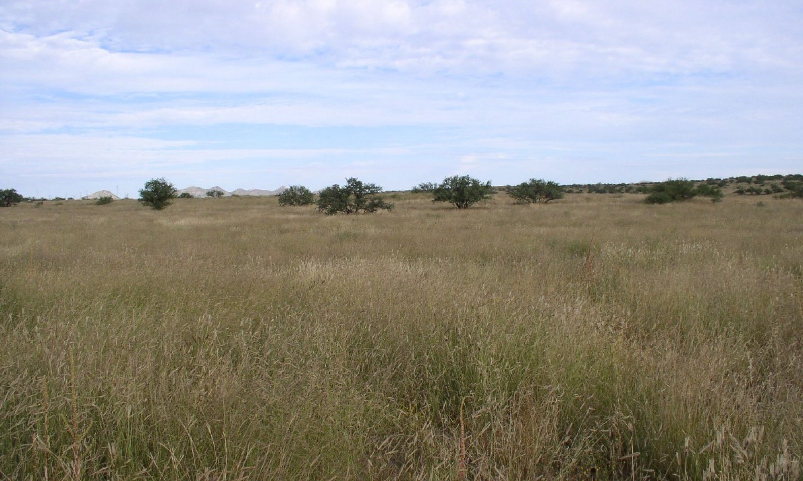
The potential plant community on this site is dominated by warm-season, perennial midgrasses. The major perennial species are well dispersed throughout the plant community. Perennial forbs, several species of low shrubs and succulents are well represented in the plant community. The aspect is open grassland to oak-grass savannah.
Mesquite and Lehmann lovegrass are at the upper limits of their elevation range, but can increase to dominance on this site, especially with climatic warming. Naturally occurring fires in Jun-Aug are an important factor in shaping this plant community. Fire-free intervals range from 10-20 years.
Periodic drought can occur in this LRA and cause significant grass mortality. Droughts in the early 30s, mid-50s, 1975-76 and 1988-89 resulted in the loss of much of the perennial grass cover on this site. This site recovers very rapidly, however, due to the favorable climate prevailing in this sub-resource area and thick, coarse textured soil surfaces.State and transition model
Custom diagramStandard diagram
Figure 4. Sandyloam Upland 41-1 STM diagram
More interactive model formats are also available. View Interactive Models
More interactive model formats are also available. View Interactive Models
Click on state and transition labels to scroll to the respective textState 1 submodel, plant communities
State 2 submodel, plant communities
State 3 submodel, plant communities
State 4 submodel, plant communities
State 1
ReferenceCommunity 1.1
Grassland-Oak Savannah (HCPC)
Figure 5. Sandy Loam Upland 16-20" pz. HCPC
The historic native state includes the native plant communities that occur on the site, including historic climax plant community. This state includes other plant communities that naturally occupy the site following fire, drought, flooding, herbivores, and other natural disturbances. The historic plant community represents the natural climax community that eventually reoccupies the site with proper management.
The potential plant community on this site is dominated by warm-season, perennial midgrasses. The major perennial species are well dispersed throughout the plant community. Perennial forbs, several species of low shrubs and succulents are well represented in the plant community. The aspect is open grassland to oak-grass savannah.
Mesquite and Lehmann lovegrass are at the upper limits of their elevation range, but can increase to dominance on this site, especially with climatic warming. Naturally occurring fires in Jun-Aug are an important factor in shaping this plant community. Fire-free intervals range from 10-20 years.
Periodic drought can occur in this LRA and cause significant grass mortality. Droughts in the early 30s, mid-50s, 1975-76 and 1988-89 resulted in the loss of much of the perennial grass cover on this site. This site recovers very rapidly, however, due to the favorable climate prevailing in this sub-resource area and thick, coarse textured soil surfaces.Figure 6. Annual production by plant type (representative values) or group (midpoint values)
Table 5. Annual production by plant type
Plant type Low
(lb/acre)Representative value
(lb/acre)High
(lb/acre)Grass/Grasslike 1065 1600 2112 Forb 17 30 205 Tree 0 5 30 Shrub/Vine 2 10 27 Total 1084 1645 2374 Table 6. Soil surface cover
Tree basal cover 0% Shrub/vine/liana basal cover 0-0% Grass/grasslike basal cover 10-20% Forb basal cover 0-0% Non-vascular plants 0-0% Biological crusts 0-10% Litter 30-70% Surface fragments >0.25" and <=3" 10-20% Surface fragments >3" 0-10% Bedrock 0% Water 0% Bare ground 10-40% Table 7. Canopy structure (% cover)
Height Above Ground (ft) Tree Shrub/Vine Grass/
GrasslikeForb <0.5 – 0-1% 1-5% 0-5% >0.5 <= 1 – 0-1% 10-20% 1-5% >1 <= 2 – 0-3% 20-40% 0-10% >2 <= 4.5 – 0-1% 5-15% 0-1% >4.5 <= 13 0-1% – 0-1% – >13 <= 40 0-5% – – – >40 <= 80 – – – – >80 <= 120 – – – – >120 – – – – Figure 7. Plant community growth curve (percent production by month). AZ4111 , 41.1 16-30. Growth begins in the spring, semi-dormancy occurs during the June drought, most growth occurs during the summer rainy season..
Jan Feb Mar Apr May Jun Jul Aug Sep Oct Nov Dec J F M A M J J A S O N D 0 0 0 5 10 0 15 45 20 5 0 0 Community 1.2
Annual ForbsAnnual forbs like camphorweed, annual goldeneye, gumweed and sorrel buckwheat dominate the plant community with marked reduction in mid-grass canopies. Short grasses are somewhat reduced.
Community 1.3
Short GrassesContinuous, unmanaged grazing at high utilization levels removes midgrasses from the plant community. Midgrasses are replaced by a sod-bound form of blue grama and annual grasses and forbs. With severe deterioration, shrubby species like burroweed, wooly groundsel and yerba-de-pasmo can increase to dominate the plant community.
Pathway 1.1a
Community 1.1 to 1.2Extended periods with no disturbance (fire or grazing) allow the build-up of perennial grass biomass that result in plant decadence. Periodic drought also causes significant grass mortality.
Pathway 1.1b
Community 1.1 to 1.3Continuous, unmanaged, grazing with heavy to severe utilization removes perennial mid-grasses and affects natural fire cycles.
Pathway 1.2a
Community 1.2 to 1.1With managed grazing, this site recovers moderately well in 2 to 3 years due to the favorable climate prevailing in this sub-resource area.
Pathway 1.2b
Community 1.2 to 1.3Unmanaged grazing during a favorable precipitation period inhibits perennial midgrass recruitment.
Pathway 1.3a
Community 1.3 to 1.1With managed grazing, midgrasses regain their dominance of the plant communities.
Pathway 1.3b
Community 1.3 to 1.2Natural fire cycles are interrupted from lack of fine fuels caused by continuous, unmanaged grazing at high utilization levels.
State 2
Exotic GrassesCommunity 2.1
Exotic Grassland
Figure 8. Sandy Loam Upland 16-20" pz. Lehmann lovegrass
This state occurs where African lovegrass species either have invaded from established stands or from direct seeding of these areas. Lehmann, Boer, weeping lovegrass, and in some places the yellow bluestems, are dominant and native perennial grasses and forbs exist only in trace amounts. Cover and production of these species is very high and site stability and hydrologic function are good.
State 3
Mesquite, Juniper InvadedCommunity 3.1
Mesquite and Juniper
Figure 9. Sandy Loam Upland 16-20" pz. Mesquite
With continuous grazing, a nearby seed source, and in the absence of fire for long periods of time; velvet mesquite, western honey mesquite, alligator juniper and / or one seed juniper can invade and increase to dominate the site. Canopy cover ranges from 1 to 30%. Sheet and rill erosion can begin to accelerate at the higher canopy levels.
State 4
ErodedCommunity 4.1
Loamy Upland CommunityThis state occurs where accelerated sheet and rill erosion has removed the soil surface (A horizon). This can be due to the interactions of fire, continuous grazing and drought; resulting in compaction and loss of grass cover. On those soils with argillic horizons; erosion that removes all but 3 inches of the surface has reduced the site potential to something similar to that of Loamy Upland ecological site (R041XA108AZ). On those soils with sandyloam textures throughout; erosion has left a patterns of rills that change the hydrology of the site and reduce production and cover.
Transition T1A
State 1 to 2Non-native bunchgrass seed is purposely planted or inadvertently introduced into the plant community (wind-blown or mechanical transport). Disturbances such as fire or drought can disrupt the native perennials allowing the non-native grasses an opportunity to expand their range from disturbed or planted areas. Long term events such as continuous unmanaged grazing or community phase pathway 1.1a (shift to the Annual Forbs community phase 1.2) allow non-native bunchgrasses a competitive advantage over natives.
Transition T1B
State 1 to 3Continuous unmanaged grazing with heavy to severe utilization results in persistently low perennial grass cover and extended fire free periods. Mesquite and juniper increase in size and number. Remnant native perennial grasses cannot re-colonize areas with shrub competition.
Transition T1C
State 1 to 4Long-term, continuous, unmanaged grazing with heavy to severe utilization affects soil site stability and hydrologic functioning. Reduced soil cover, compaction, and A Horizon loss compound the effect of plant community changes (increased shrub/decreased perennial grass community) to increase surface water run-off rather than infiltration. Drought conditions accelerate this transition. Persistent reduced infiltration severely limits perennial grass recruitment.
Restoration pathway R2A
State 2 to 1No restoration pathway known at this time. Perhaps future development of herbicide or biological treatment to remove perennial exotics will occur.
Transition T2A
State 2 to 3Continuous unmanaged grazing with heavy to severe utilization results in persistently low perennial grass cover and extended fire free periods. Mesquite and juniper increase in size and number. Remnant native perennial grasses cannot re-colonize areas with shrub competition.
Restoration pathway R3A
State 3 to 1Woody species control, native species seeding (as needed) supported by managed grazing. Shrub control maintained with herbicide and/or prescribed burning.
Restoration pathway R3B
State 3 to 2Restoration activities conducted when a non-native seed bank is present on site (African lovegrasses or yellow bluestem present along trails, roads or in disturbed areas) can result in an exotic grassland community. Native species seeding may enhance the native grass component. Restoration practices are woody species control and native species seeding (as needed) supported by managed grazing. Shrub control maintained with herbicide may favor the native grasses while prescribed burning may favor non-natives. Burning the mixed shrub community with a non-native grass seed source present can result in an exotic grassland co-dominant with shrubs.
Transition T3A
State 3 to 4Long-term, continuous, unmanaged grazing with heavy to severe utilization affects soil site stability and hydrologic functioning. Reduced soil cover, compaction, and A Horizon loss compound the effect of plant community changes (increased shrub/decreased perennial grass community) to increase surface water run-off rather than infiltration. Drought conditions accelerate this transition. Persistent reduced infiltration severely limits perennial grass recruitment.
Additional community tables
Table 8. Community 1.1 plant community composition
Group Common name Symbol Scientific name Annual production () Foliar cover (%) Grass/Grasslike1 Dominant mid-grasses 800–1300 sideoats grama BOCU Bouteloua curtipendula 200–600 – plains lovegrass ERIN Eragrostis intermedia 200–600 – green sprangletop LEDU Leptochloa dubia 100–300 – cane bluestem BOBA3 Bothriochloa barbinodis 50–300 – Arizona cottontop DICA8 Digitaria californica 25–200 – spiked crinkleawn TRSP12 Trachypogon spicatus 0–200 – 2 Dominant short grasses 250–500 blue grama BOGR2 Bouteloua gracilis 100–400 – black grama BOER4 Bouteloua eriopoda 10–200 – hairy grama BOHI2 Bouteloua hirsuta 0–50 – fall witchgrass DICO6 Digitaria cognata 10–50 – common wolfstail LYPH Lycurus phleoides 5–50 – 3 Perennial threeawns 10–80 Orcutt's threeawn ARSCO Aristida schiedeana var. orcuttiana 0–50 – spidergrass ARTE3 Aristida ternipes 5–40 – spidergrass ARTEG Aristida ternipes var. gentilis 0–20 – Santa Rita threeawn ARCAG Aristida californica var. glabrata 0–5 – poverty threeawn ARDI5 Aristida divaricata 0–5 – Havard's threeawn ARHA3 Aristida havardii 0–5 – Fendler threeawn ARPUL Aristida purpurea var. longiseta 0–5 – blue threeawn ARPUN Aristida purpurea var. nealleyi 0–5 – Parish's threeawn ARPUP5 Aristida purpurea var. parishii 0–5 – Wright's threeawn ARPUW Aristida purpurea var. wrightii 0–5 – 4 Annual Grasses 5–100 prairie threeawn AROL Aristida oligantha 1–15 – sixweeks fescue VUOC Vulpia octoflora 0–15 – Mexican panicgrass PAHI5 Panicum hirticaule 1–10 – feather fingergrass CHVI4 Chloris virgata 0–10 – tapertip cupgrass ERACA Eriochloa acuminata var. acuminata 0–10 – pitscale grass HAGR3 Hackelochloa granularis 1–10 – sweet tanglehead HEME Heteropogon melanocarpus 0–10 – Mexican sprangletop LEFUU Leptochloa fusca ssp. uninervia 0–10 – Arizona signalgrass URAR Urochloa arizonica 1–10 – mucronate sprangeltop LEPAB Leptochloa panicea ssp. brachiata 0–5 – tufted lovegrass ERPEP2 Eragrostis pectinacea var. pectinacea 0–5 – witchgrass PACA6 Panicum capillare 0–5 – needle grama BOAR Bouteloua aristidoides 0–5 – sixweeks grama BOBA2 Bouteloua barbata 0–5 – little grapefern BOSI Botrychium simplex 0–2 – matted grama BOSI2 Bouteloua simplex 0–2 – Arizona brome BRAR4 Bromus arizonicus 0–2 – sixweeks threeawn ARAD Aristida adscensionis 0–2 – Mexican lovegrass ERME Eragrostis mexicana 0–2 – desert lovegrass ERPEM Eragrostis pectinacea var. miserrima 0–2 – delicate muhly MUFR Muhlenbergia fragilis 0–1 – littleseed muhly MUMI Muhlenbergia microsperma 0–1 – poverty dropseed SPVA Sporobolus vaginiflorus 0–1 – prairie false oat TRIN5 Trisetum interruptum 0–1 – 5 Cool season grasses 2–50 squirreltail ELELE Elymus elymoides ssp. elymoides 1–30 – pinyon ricegrass PIFI Piptochaetium fimbriatum 0–25 – sedge CAREX Carex 1–10 – flatsedge CYPER Cyperus 0–10 – densetuft hairsedge BUCA2 Bulbostylis capillaris 0–2 – 6 Miscellaneous perennial grasses 5–100 Rothrock's grama BORO2 Bouteloua rothrockii 1–50 – silver bluestem BOSA Bothriochloa saccharoides 0–50 – tanglehead HECO10 Heteropogon contortus 1–50 – spike dropseed SPCO4 Sporobolus contractus 1–50 – slender grama BORE2 Bouteloua repens 0–25 – sand dropseed SPCR Sporobolus cryptandrus 1–20 – sprucetop grama BOCH Bouteloua chondrosioides 0–15 – purple grama BORA Bouteloua radicosa 0–15 – woolyspike balsamscale ELBA Elionurus barbiculmis 0–10 – curly-mesquite HIBE Hilaria belangeri 0–10 – bullgrass MUEM Muhlenbergia emersleyi 0–10 – bush muhly MUPO2 Muhlenbergia porteri 1–10 – creeping muhly MURE Muhlenbergia repens 0–10 – purple muhly MURI3 Muhlenbergia rigida 0–10 – bulb panicgrass PABU Panicum bulbosum 0–10 – Hall's panicgrass PAHA Panicum hallii 0–10 – big sacaton SPWR2 Sporobolus wrightii 0–10 – Texas bluestem SCCI2 Schizachyrium cirratum 0–10 – little bluestem SCSC Schizachyrium scoparium 0–10 – plains bristlegrass SEVU2 Setaria vulpiseta 0–10 – Arizona muhly MUAR3 Muhlenbergia arizonica 0–5 – vine mesquite PAOB Panicum obtusum 0–5 – Porter's melicgrass MEPO Melica porteri 0–2 – nineawn pappusgrass ENDE Enneapogon desvauxii 0–1 – Forb7 Perennial forbs 15–55 Cooley's bundleflower DECO2 Desmanthus cooleyi 1–10 – bluedicks DICA14 Dichelostemma capitatum 1–10 – orange fameflower PHAU13 Phemeranthus aurantiacus 0–10 – wild dwarf morning-glory EVAR Evolvulus arizonicus 0–5 – spreading snakeherb DYSCD Dyschoriste schiedeana var. decumbens 0–5 – rose heath CHER2 Chaetopappa ericoides 0–5 – leatherweed CRPO5 Croton pottsii 0–5 – Texas snoutbean RHSET Rhynchosia senna var. texana 0–5 – lacy tansyaster MAPI Machaeranthera pinnatifida 0–2 – shrubby purslane POSU3 Portulaca suffrutescens 0–2 – brownplume wirelettuce STPA4 Stephanomeria pauciflora 0–2 – Missouri goldenrod SOMI2 Solidago missouriensis 0–2 – Rocky Mountain zinnia ZIGR Zinnia grandiflora 0–2 – tuber anemone ANTU Anemone tuberosa 0–2 – Missouri gourd CUFO Cucurbita foetidissima 0–2 – largeflower onion ALMA4 Allium macropetalum 0–2 – weakleaf bur ragweed AMCO3 Ambrosia confertiflora 1–2 – white sagebrush ARLU Artemisia ludoviciana 0–2 – spreading fleabane ERDI4 Erigeron divergens 0–2 – trailing fleabane ERFL Erigeron flagellaris 0–2 – small matweed GUDE Guilleminea densa 0–2 – Rutter's false goldenaster HERU3 Heterotheca rutteri 0–2 – Wright's deervetch LOWR Lotus wrightii 0–2 – silver dwarf morning-glory EVSE Evolvulus sericeus 0–2 – tufted evening primrose OECA10 Oenothera caespitosa 0–2 – locoweed OXYTR Oxytropis 0–1 – beardlip penstemon PEBA2 Penstemon barbatus 0–1 – Cochise beardtongue PEDA Penstemon dasyphyllus 0–1 – longstalk chinchweed PELO Pectis longipes 0–1 – Parry's beardtongue PEPA24 Penstemon parryi 0–1 – slimleaf bean PHAN3 Phaseolus angustissimus 0–1 – ivyleaf groundcherry PHHE4 Physalis hederifolia 0–1 – white milkwort POAL4 Polygala alba 0–1 – velvetseed milkwort POOB Polygala obscura 0–1 – Arizona snakecotton FRAR2 Froelichia arizonica 0–1 – scarlet beeblossom GACO5 Gaura coccinea 0–1 – pearly globe amaranth GONI Gomphrena nitida 0–1 – variableleaf bushbean MAGI2 Macroptilium gibbosifolium 0–1 – shaggy dwarf morning-glory EVNU Evolvulus nuttallianus 0–1 – Indian rushpea HOGL2 Hoffmannseggia glauca 0–1 – red bluet HORU Houstonia rubra 0–1 – babyslippers HYVE Hybanthus verticillatus 0–1 – ragged nettlespurge JAMA Jatropha macrorhiza 0–1 – San Pedro daisy LAPO4 Lasianthaea podocephala 0–1 – Fendler's bladderpod LEFE Lesquerella fendleri 0–1 – narrowleaf stoneseed LIIN2 Lithospermum incisum 0–1 – Lewis flax LILE3 Linum lewisii 0–1 – Greene's bird's-foot trefoil LOGR4 Lotus greenei 0–1 – Mexican fireplant EUHE4 Euphorbia heterophylla 0–1 – sun spurge EURA2 Euphorbia radians 0–1 – Torrey's craglily ECFL Echeandia flavescens 0–1 – perennial rockcress ARPE2 Arabis perennans 0–1 – Watson's dutchman's pipe ARWA Aristolochia watsonii 0–1 – Arizona milkvetch ASAR6 Astragalus arizonicus 0–1 – spider milkweed ASAS Asclepias asperula 0–1 – chaparral asphead ASHI3 Aspicarpa hirtella 0–1 – broadleaf milkweed ASLA4 Asclepias latifolia 0–1 – woolly locoweed ASMOB Astragalus mollissimus var. bigelovii 0–1 – sheep milkvetch ASNO3 Astragalus nothoxys 0–1 – horsetail milkweed ASSU2 Asclepias subverticillata 0–1 – dense ayenia AYMI Ayenia microphylla 0–1 – hairyseed bahia BAAB Bahia absinthifolia 0–1 – lyreleaf greeneyes BELY Berlandiera lyrata 0–1 – scarlet spiderling BOCO Boerhavia coccinea 0–1 – dwarf stickpea CAHUR Calliandra humilis var. reticulata 0–1 – wholeleaf Indian paintbrush CAIN14 Castilleja integra 0–1 – desert mariposa lily CAKE Calochortus kennedyi 0–1 – sego lily CANU3 Calochortus nuttallii 0–1 – Indian paintbrush CASTI2 Castilleja 0–1 – whitemargin sandmat CHAL11 Chamaesyce albomarginata 0–1 – Mexican yellowshow AMPA3 Amoreuxia palmatifida 0–1 – Cuman ragweed AMPS Ambrosia psilostachya 0–1 – birdbill dayflower CODI4 Commelina dianthifolia 0–1 – Texas bindweed COEQ Convolvulus equitans 0–1 – whitemouth dayflower COER Commelina erecta 0–1 – coyote gourd CUPA Cucurbita palmata 0–1 – whiteflower prairie clover DAAL Dalea albiflora 0–1 – James' prairie clover DAJA Dalea jamesii 0–1 – dwarf prairie clover DANA Dalea nana 0–1 – downy prairie clover DANE Dalea neomexicana 0–1 – melon loco APUN Apodanthera undulata 0–1 – fingerleaf gourd CUDI Cucurbita digitata 0–1 – copper globemallow SPAN3 Sphaeralcea angustifolia 0–1 – gooseberryleaf globemallow SPGR2 Sphaeralcea grossulariifolia 0–1 – jewels of Opar TAPA2 Talinum paniculatum 0–1 – Coulter's wrinklefruit TECO Tetraclea coulteri 0–1 – hairy fournwort TENE Tetramerium nervosum 0–1 – longstalk greenthread THLO Thelesperma longipes 0–1 – Hopi tea greenthread THME Thelesperma megapotamicum 0–1 – pinewoods spiderwort TRPI Tradescantia pinetorum 0–1 – branched noseburn TRRA5 Tragia ramosa 0–1 – Fort Huachuca vervain VEGR2 Verbena gracilis 0–1 – American vetch VIAM Vicia americana 0–1 – Louisiana vetch VILUL2 Vicia ludoviciana ssp. ludoviciana 0–1 – copper zephyrlily ZELO Zephyranthes longifolia 0–1 – slimflower scurfpea PSTE5 Psoralidium tenuiflorum 0–1 – buffpetal RHPH2 Rhynchosida physocalyx 0–1 – Mexican star MIBI2 Milla biflora 0–1 – lemon beebalm MOCIA Monarda citriodora ssp. austromontana 0–1 – slimleaf plainsmustard SCLI12 Schoenocrambe linearifolia 0–1 – twinleaf senna SEBA3 Senna bauhinioides 0–1 – Lemmon's ragwort SELE8 Senecio lemmonii 0–1 – salt spring checkerbloom SINE3 Sidalcea neomexicana 0–1 – silverleaf nightshade SOEL Solanum elaeagnifolium 0–1 – trailing windmills ALIN Allionia incarnata 0–1 – 8 Annual Forbs 2–150 longleaf false goldeneye HELOA2 Heliomeris longifolia var. annua 1–50 – camphorweed HESU3 Heterotheca subaxillaris 1–50 – Arizona poppy KAGR Kallstroemia grandiflora 0–25 – warty caltrop KAPA Kallstroemia parviflora 0–10 – intermediate pepperweed LEVIM Lepidium virginicum var. medium 0–10 – slender goldenweed MAGR10 Machaeranthera gracilis 1–10 – tanseyleaf tansyaster MATA2 Machaeranthera tanacetifolia 0–10 – whitestem blazingstar MEAL6 Mentzelia albicaulis 0–10 – sweet four o'clock MILO2 Mirabilis longiflora 0–10 – pitseed goosefoot CHBE4 Chenopodium berlandieri 0–10 – New Mexico goosefoot CHNE3 Chenopodium neomexicanum 0–10 – sensitive partridge pea CHNI2 Chamaecrista nictitans 0–10 – New Mexico thistle CINE Cirsium neomexicanum 0–10 – smallflowered milkvetch ASNU4 Astragalus nuttallianus 0–10 – Thurber's milkvetch ASTH Astragalus thurberi 0–10 – carelessweed AMPA Amaranthus palmeri 0–5 – western tansymustard DEPI Descurainia pinnata 0–5 – Abert's buckwheat ERAB2 Eriogonum abertianum 0–5 – sorrel buckwheat ERPO4 Eriogonum polycladon 0–5 – Arizona popcornflower PLAR Plagiobothrys arizonicus 0–5 – woolly plantain PLPA2 Plantago patagonica 0–5 – Thurber's morning-glory IPTH Ipomoea thurberi 0–2 – sawtooth sage SASU7 Salvia subincisa 0–2 – spreading fanpetals SIAB Sida abutifolia 0–2 – Fendler's desertdandelion MAFE Malacothrix fendleri 0–2 – golden crownbeard VEEN Verbesina encelioides 0–2 – wedgeleaf draba DRCU Draba cuneifolia 0–2 – redstar IPCO3 Ipomoea coccinea 0–2 – scrambled eggs COAU2 Corydalis aurea 0–2 – New Mexico copperleaf ACNE Acalypha neomexicana 0–2 – crested anoda ANCR2 Anoda cristata 0–1 – southwestern pricklypoppy ARPL3 Argemone pleiacantha 0–1 – halfmoon milkvetch ASAL6 Astragalus allochrous 0–1 – wheelscale saltbush ATEL Atriplex elegans 0–1 – fewflower beggarticks BILE Bidens leptocephala 0–1 – Coulter's spiderling BOCO2 Boerhavia coulteri 0–1 – erect spiderling BOER Boerhavia erecta 0–1 – hoary bowlesia BOIN3 Bowlesia incana 0–1 – purple spiderling BOPU Boerhavia purpurascens 0–1 – fringed redmaids CACI2 Calandrinia ciliata 0–1 – cryptantha CRYPT Cryptantha 0–1 – Chihuahuan prairie clover DAEX2 Dalea exigua 0–1 – American wild carrot DAPU3 Daucus pusillus 0–1 – sacred thorn-apple DAWR2 Datura wrightii 0–1 – poorjoe DITE2 Diodia teres 0–1 – miner's lettuce CLPEP Claytonia perfoliata ssp. perfoliata 0–1 – threadstem sandmat CHRE4 Chamaesyce revoluta 0–1 – thymeleaf sandmat CHSE6 Chamaesyce serpyllifolia 0–1 – slimseed sandmat CHST8 Chamaesyce stictospora 0–1 – royal sandmat CHDI5 Chamaesyce dioica 0–1 – pillpod sandmat CHHI3 Chamaesyce hirta 0–1 – hyssopleaf sandmat CHHY3 Chamaesyce hyssopifolia 0–1 – flaxflowered ipomopsis IPLOL Ipomopsis longiflora ssp. longiflora 0–1 – crestrib morning-glory IPCO2 Ipomoea costellata 0–1 – miniature woollystar ERDI2 Eriastrum diffusum 0–1 – spreading fleabane ERDI4 Erigeron divergens 0–1 – California poppy ESCAM Eschscholzia californica ssp. mexicana 0–1 – Arizona blanketflower GAAR2 Gaillardia arizonica 0–1 – red dome blanketflower GAPI Gaillardia pinnatifida 0–1 – lesser yellowthroat gilia GIFL Gilia flavocincta 0–1 – El Paso gilia GIME Gilia mexicana 0–1 – Dakota mock vervain GLBIB Glandularia bipinnatifida var. bipinnatifida 0–1 – curlytop gumweed GRNUA Grindelia nuda var. aphanactis 0–1 – sleepy silene SIAN2 Silene antirrhina 0–1 – El Paso skyrocket IPTH2 Ipomopsis thurberi 0–1 – desert evening primrose OEPR Oenothera primiveris 0–1 – Arizona phacelia PHAR13 Phacelia arizonica 0–1 – Mangas Spring phacelia PHBO4 Phacelia bombycina 0–1 – purslane PORTU Portulaca 0–1 – yerba porosa PORU6 Porophyllum ruderale 0–1 – desert unicorn-plant PRAL4 Proboscidea althaeifolia 0–1 – doubleclaw PRPA2 Proboscidea parviflora 0–1 – Wright's cudweed PSCAC2 Pseudognaphalium canescens ssp. canescens 0–1 – Abert's creeping zinnia SAAB Sanvitalia abertii 0–1 – dotted blazing star LIPU Liatris punctata 0–1 – plains flax LIPU4 Linum puberulum 0–1 – foothill deervetch LOHU2 Lotus humistratus 0–1 – coastal bird's-foot trefoil LOSAB Lotus salsuginosus var. brevivexillus 0–1 – shortstem lupine LUBR2 Lupinus brevicaulis 0–1 – bajada lupine LUCOC Lupinus concinnus ssp. concinnus 0–1 – Gordon's bladderpod LEGO Lesquerella gordonii 0–1 – broadleaved pepperweed LELA2 Lepidium latifolium 0–1 – Shrub/Vine9 Dominant half shrubs 2–20 bastardsage ERWR Eriogonum wrightii 1–20 – dwarf milkweed ASIN14 Asclepias involucrata 1–15 – milkvetch ASTRA Astragalus 1–15 – lyreleaf greeneyes BELY Berlandiera lyrata 1–15 – scarlet spiderling BOCO Boerhavia coccinea 1–15 – fringed redmaids CACI2 Calandrinia ciliata 1–15 – Indian paintbrush CASTI2 Castilleja 1–15 – lambsquarters CHAL7 Chenopodium album 1–15 – hyssopleaf sandmat CHHY3 Chamaesyce hyssopifolia 1–15 – New Mexico thistle CINE Cirsium neomexicanum 1–15 – smooth babybonnets COGL7 Coursetia glabella 1–15 – leatherweed CRPOP Croton pottsii var. pottsii 1–15 – fingerleaf gourd CUDI Cucurbita digitata 1–15 – coyote gourd CUPA Cucurbita palmata 1–15 – American wild carrot DAPU3 Daucus pusillus 1–15 – New Mexico ticktrefoil DENE Desmodium neomexicanum 1–15 – western tansymustard DEPI Descurainia pinnata 1–15 – Torrey's craglily ECFL Echeandia flavescens 1–15 – miniature woollystar ERDI2 Eriastrum diffusum 1–15 – Bessey's stickseed HABE3 Hackelia besseyi 1–15 – Indian rushpea HOGL2 Hoffmannseggia glauca 1–15 – rubberweed HYMEN7 Hymenoxys 1–15 – ragged nettlespurge JAMA Jatropha macrorhiza 1–15 – Arizona poppy KAGR Kallstroemia grandiflora 1–15 – Coulter's horseweed LACO13 Laennecia coulteri 1–15 – Fendler's bladderpod LEFE Lesquerella fendleri 1–15 – Goodding's bladderpod LEGO2 Lesquerella gooddingii 1–15 – intermediate pepperweed LEVIM Lepidium virginicum var. medium 1–15 – Lewis flax LILE3 Linum lewisii 1–15 – plains flax LIPU4 Linum puberulum 1–15 – woodland-star LITHO2 Lithophragma 1–15 – Greene's bird's-foot trefoil LOGR4 Lotus greenei 1–15 – foothill deervetch LOHU2 Lotus humistratus 1–15 – coastal bird's-foot trefoil LOSAB Lotus salsuginosus var. brevivexillus 1–15 – lupine LUPIN Lupinus 1–15 – hoary tansyaster MACA2 Machaeranthera canescens 1–15 – slender goldenweed MAGR10 Machaeranthera gracilis 1–15 – whitestem blazingstar MEAL6 Mentzelia albicaulis 1–15 – lemon beebalm MOCIA Monarda citriodora ssp. austromontana 1–15 – green carpetweed MOVE Mollugo verticillata 1–15 – desert evening primrose OEPR Oenothera primiveris 1–15 – Drummond's woodsorrel OXDR Oxalis drummondii 1–15 – palafox PALAF Palafoxia 1–15 – longstalk chinchweed PELO Pectis longipes 1–15 – phacelia PHACE Phacelia 1–15 – ivyleaf groundcherry PHHE4 Physalis hederifolia 1–15 – phlox PHLOX Phlox 1–15 – Arizona popcornflower PLAR Plagiobothrys arizonicus 1–15 – desert Indianwheat PLOV Plantago ovata 1–15 – little hogweed POOL Portulaca oleracea 1–15 – doubleclaw PRPA2 Proboscidea parviflora 1–15 – slimflower scurfpea PSTE5 Psoralidium tenuiflorum 1–15 – chia SACO6 Salvia columbariae 1–15 – twinleaf senna SEBA3 Senna bauhinioides 1–15 – sleepy silene SIAN2 Silene antirrhina 1–15 – silverleaf nightshade SOEL Solanum elaeagnifolium 1–15 – Missouri goldenrod SOMI2 Solidago missouriensis 1–15 – jewels of Opar TAPA2 Talinum paniculatum 1–15 – Hopi tea greenthread THME Thelesperma megapotamicum 1–15 – Palmer's crinklemat TIPA Tiquilia palmeri 1–15 – pinewoods spiderwort TRPI Tradescantia pinetorum 1–15 – branched noseburn TRRA5 Tragia ramosa 1–15 – Fort Huachuca vervain VEGR2 Verbena gracilis 1–15 – American vetch VIAM Vicia americana 1–15 – Louisiana vetch VILUL2 Vicia ludoviciana ssp. ludoviciana 1–15 – Rocky Mountain zinnia ZIGR Zinnia grandiflora 1–15 – yerba de pasmo BAPT Baccharis pteronioides 1–10 – fairyduster CAER Calliandra eriophylla 0–10 – prairie acacia ACAN Acacia angustissima 0–5 – 10 Miscellanous shrubs 0–5 catclaw acacia ACGR Acacia greggii 0–2 – Apache plume FAPA Fallugia paradoxa 0–2 – burroweed ISTE2 Isocoma tenuisecta 0–1 – littleleaf ratany KRER Krameria erecta 0–1 – trailing krameria KRLA Krameria lanceolata 0–1 – pale desert-thorn LYPA Lycium pallidum 0–1 – catclaw mimosa MIACB Mimosa aculeaticarpa var. biuncifera 0–1 – velvetpod mimosa MIDY Mimosa dysocarpa 0–1 – skunkbush sumac RHTR Rhus trilobata 0–1 – threadleaf ragwort SEFL3 Senecio flaccidus 0–1 – pointleaf manzanita ARPU5 Arctostaphylos pungens 0–1 – fourwing saltbush ATCA2 Atriplex canescens 0–1 – longleaf jointfir EPTR Ephedra trifurca 0–1 – rubber rabbitbrush ERNAC3 Ericameria nauseosa ssp. consimilis var. ceruminosa 0–1 – 11 Succulents 0–2 sacahuista NOMI Nolina microcarpa 0–2 – cactus apple OPEN3 Opuntia engelmannii 0–1 – twistspine pricklypear OPMA2 Opuntia macrorhiza 0–1 – soaptree yucca YUEL Yucca elata 0–1 – Palmer's century plant AGPA3 Agave palmeri 0–1 – Parry's agave AGPA4 Agave parryi 0–1 – walkingstick cactus CYSP8 Cylindropuntia spinosior 0–1 – pinkflower hedgehog cactus ECFEF3 Echinocereus fendleri ssp. fendleri 0–1 – white fishhook cactus ECIN2 Echinomastus intertextus 0–1 – rainbow hedgehog cactus ECRI3 Echinocereus rigidissimus 0–1 – spinystar ESVI2 Escobaria vivipara 0–1 – Macdougal's nipple cactus MAHEM Mammillaria heyderi var. macdougalii 0–1 – Tree12 Trees 0–30 Arizona white oak QUAR Quercus arizonica 0–30 – Emory oak QUEM Quercus emoryi 0–30 – alligator juniper JUDE2 Juniperus deppeana 0–1 – oneseed juniper JUMO Juniperus monosperma 0–1 – Table 9. Community 1.2 plant community composition
Group Common name Symbol Scientific name Annual production () Foliar cover (%) Table 10. Community 1.3 plant community composition
Group Common name Symbol Scientific name Annual production () Foliar cover (%) Table 11. Community 2.1 plant community composition
Group Common name Symbol Scientific name Annual production () Foliar cover (%) Table 12. Community 3.1 plant community composition
Group Common name Symbol Scientific name Annual production () Foliar cover (%) Table 13. Community 4.1 plant community composition
Group Common name Symbol Scientific name Annual production () Foliar cover (%) Interpretations
Animal community
The plant community on this site is suitable for grazing by all classes of livestock at any season. The plant community will be low in digestable protein in the winter. Phosphorous may be deficient throughout the year. Grazing should be managed to maintain a vigorous stand of midgrasses to keep Lehmann lovegrass out of the community and to prevent forbs like camphorweed and annual buckwheat from becoming dominant in the plant community. Annual goldeneye can cause problems in the fall after unusually wet winter-spring season.
The site is a primary habitat for pronghorn antelope in southeastern Arizona. Water developments are very important to both large and small wildlife species on the site. The site is open grassland and rich in both grass and forb species, making it home to a great variety of insect, bird, small mammal and reptile species.
In areas adjacent to woodlands, this site is heavily used as a forage area for large mammals like mule deer and whitetail deer. Natural water is lacking on this site.Hydrological functions
Due to thick, coarse textured soil surfaces this site is a poor producer of runoff.
Recreational uses
Hunting, hiking, horseback riding, camping, bird watching, photography.
Wood products
None unless the area has been invaded by mesquite or juniper.
Other products
Grass seed, medicinal herbs like yerba de pasmo and mormon tea.
Supporting information
Inventory data references
Range 417s include 1 in excellent condition and 2 in good condition.
Type locality
Location 1: Cochise County, AZ Township/Range/Section T22S R20E S28 General legal description NE 1/2 of section. Douglas FO - Ft. Huachuca - South Range Location 2: Pima County, AZ Township/Range/Section T20S R17E S11 General legal description SE 1/2 of section. Tucson - Empire Ranch Location 3: Santa Cruz County, AZ Township/Range/Section T21S R18E S23 General legal description Audubon Research Ranch Other references
Griffith, G.E., Omernik, J.M., Johnson, C.B., and Turner, D.S., 2014, Ecoregions of Arizona (poster): U.S. Geological Survey Open-File Report 2014-1141, with map, scale 1:1,325,000, https://dx.doi.org/10.3133/ofr20141141. ISSN 2331-1258 (online)
United States Department of Agriculture, Natural Resources Conservation Service. 2006. Land Resource Regions and Major Land Resource Areas of the United States, the Caribbean, and the Pacific Basin. U.S. Department of Agriculture Handbook 296.
McNab, W.H.; Cleland, D.T.; Freeouf, J.A.; Keys, Jr., J.E.; Nowacki, G.J.; Carpenter, C.A., comps. 2007.Contributors
Steve Barker
Dan Robinett
Larry D. EllicottApproval
Curtis Talbot, 4/09/2021
Rangeland health reference sheet
Interpreting Indicators of Rangeland Health is a qualitative assessment protocol used to determine ecosystem condition based on benchmark characteristics described in the Reference Sheet. A suite of 17 (or more) indicators are typically considered in an assessment. The ecological site(s) representative of an assessment location must be known prior to applying the protocol and must be verified based on soils and climate. Current plant community cannot be used to identify the ecological site.
Author(s)/participant(s) Wilma Renken, Dan Robinett, Larry Humphrey, Scott Stratton, Linda Kennedy Contact for lead author USDA-NRCS Tucson MLRA Soil Survey Office Date 05/01/2014 Approved by Approval date Composition (Indicators 10 and 12) based on Annual Production Indicators
-
Number and extent of rills:
None -
Presence of water flow patterns:
No water flow patterns evident. Reference site is nearly flat terrain (1-2% slope) lending to sheet flow across site. Expect waterflow pattern presence to increase in length and continuity with increasing slope; at the steepest slopes (10-15% slope), short, discontinuous water flow patterns may occupy up to 15% of the area. -
Number and height of erosional pedestals or terracettes:
Pedestals (<1") common on perennial grasses; no terracettes. -
Bare ground from Ecological Site Description or other studies (rock, litter, lichen, moss, plant canopy are not bare ground):
Bare ground after fire was 55% and decreased to 30% within 4 years. Bare (unvegetated) areas are uncommon and small (3-5 ft diameter) -
Number of gullies and erosion associated with gullies:
None -
Extent of wind scoured, blowouts and/or depositional areas:
None -
Amount of litter movement (describe size and distance expected to travel):
Most litter stays in place with some fine litter moving off bare areas. -
Soil surface (top few mm) resistance to erosion (stability values are averages - most sites will show a range of values):
Highly stable soil surface with cryptobiotic crust. Soil slake test value was "6" for all samples. -
Soil surface structure and SOM content (include type of structure and A-horizon color and thickness):
Soil surface horizon was a gravelly sandy loam, 0-4" depth, color 5YR 6/4 dry, 5YR 3/3 moist, granular structure immediately below a platy surface. -
Effect of community phase composition (relative proportion of different functional groups) and spatial distribution on infiltration and runoff:
Perennial grass basal cover (7-15%) is evenly distributed across site. Low perennial grass basal cover is expected after fire or drought. Well-dispersed perennial grasses slow rainfall run-off allowing infiltration. -
Presence and thickness of compaction layer (usually none; describe soil profile features which may be mistaken for compaction on this site):
No compaction. Average depth of penetration from an ARS field penetrometer with a 2.2 kg. sliding hammer was 4.2 cm. Argillic horizon at 4" depth may be mistaken for compaction. -
Functional/Structural Groups (list in order of descending dominance by above-ground annual-production or live foliar cover using symbols: >>, >, = to indicate much greater than, greater than, and equal to):
Dominant:
Mid-grasses > short-grassesSub-dominant:
Perennial forbs > low shrubsOther:
few succulentsAdditional:
annual grasses and annual forbs fluctuate with rainfall -
Amount of plant mortality and decadence (include which functional groups are expected to show mortality or decadence):
Very little mortality during periods between fire and drought. Mortality from fire depends upon season and intensity of burn. -
Average percent litter cover (%) and depth ( in):
30-50% litter cover with fire dynamic from 10 years of monitoring data encompassing 2 burns. Litter cover on the low end of the range is expected immmediately post-burn and increases with favorable weather and time. -
Expected annual annual-production (this is TOTAL above-ground annual-production, not just forage annual-production):
1084 lbs/ac. in a below average year; 1645 lbs/ac. in an average year; 2374 lbs/ac. in an above average year. -
Potential invasive (including noxious) species (native and non-native). List species which BOTH characterize degraded states and have the potential to become a dominant or co-dominant species on the ecological site if their future establishment and growth is not actively controlled by management interventions. Species that become dominant for only one to several years (e.g., short-term response to drought or wildfire) are not invasive plants. Note that unlike other indicators, we are describing what is NOT expected in the reference state for the ecological site:
Lehmann lovegrass, Boer lovegrass, yellow bluestem, velvet mesquite -
Perennial plant reproductive capability:
Not impaired.
Print Options
Sections
Font
AAAAOther
PrintThe Ecosystem Dynamics Interpretive Tool is an information system framework developed by the USDA-ARS Jornada Experimental Range, USDA Natural Resources Conservation Service, and New Mexico State University.
Accessibility statement


