Natural Resources
Conservation Service
Ecological site R040XD005CA
Hyper-Arid Active Alluvial Fans
2-4" p.z.
Last updated: 3/04/2025
Accessed: 06/28/2026
-
Search
Major Land Resource Area or ecological site by name and/or ID.
PreviousSectionsNextGeneral information
Provisional. A provisional ecological site description has undergone quality control and quality assurance review. It contains a working state and transition model and enough information to identify the ecological site.
MLRA notes
Major Land Resource Area (MLRA): 040X–Sonoran Basin and Range
Major land resource area (MLRA) 31 is the Lower Colorado Desert. This area is in the extreme southeastern part of California, in areas along the Colorado River, and in Western Arizona. The area is comprised of rough, barren, steep, and strongly dissected mountain ranges, generally northwest to southwest trending that are separated by intermontane basins. Elevation ranges from approximately 275 feet below sea level at the lowest point in the Salton Trough to 2700 feet along low northwest to southeast trending mountain ranges. The average annual precipitation is 2 to 6 inches with high temporal and spatial variability. Winter temperatures are mild, summer temperatures are hot, and seasonal and diurnal temperature fluctuations are large. Monthly minimum temperature averages range from 40 to 80 degrees F (4 to 27 degrees C). Monthly maximum temperature averages range from 65 to 110 degrees F (18 to 43 degrees C) (WRCC 2002). Temperatures are rarely below 28 degrees F, and extremely rarely fall below 24 degrees F. Precipitation is bimodal, with approximately 20 to 40 percent of annual precipitation falling between July and September. This summer rainfall, in combination with very hot temperatures and very few to no days of hard freeze are what characterize this MLRA and distinguish it from the Mojave Desert (MLRA 30).
XD LRU concept:
The XD LRU is an extremely hot and dry portion of the MLRA. Mean annual precipitation is about 4 inches or less where the majority of the precipitation can arrive in only a couple storm events during any given year. The very few hard freezing days allows this region to have Plant Hardiness Zones of 9b or warmer. This LRU covers most of the Lower Colorado Desert except elevations above 500 m where Plant Hardiness Zones are less than 9b.Classification relationships
Mojave Creosote Bush (Holland, 1986).
Larrea tridentata Shrubland Alliance (Sawyer et al. 2009).Ecological site concept
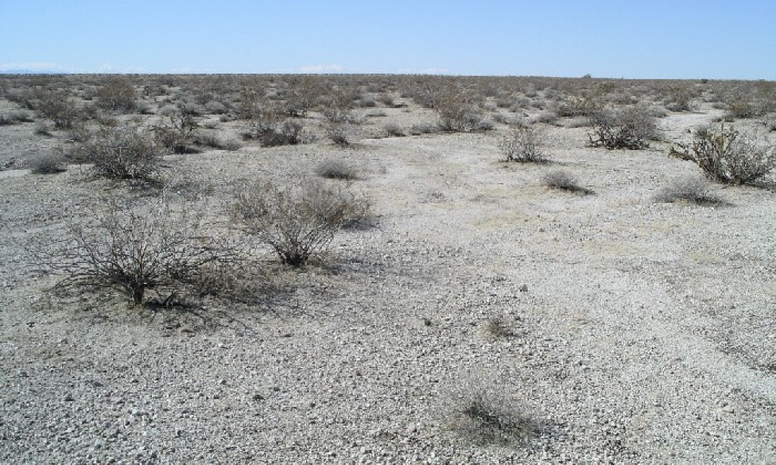
Buried fan remnants, non-buried fan remnants, fan aprons, or other alluvial fan landforms which are not an erosional fan remnant and where washes do not deeply dissect the landscape. Sheet flow creates water flow patterns where plants tend to grow. Plant species tend to die as these flow patterns migrate.
For streamflow fans see: https://www.nap.edu/read/5364/chapter/4#33
National Research Council ~NRC!. ~1997!. ‘‘Alluvial fan flooding.’’
Water Science and Technology Board, National Academy, Washington
D.C.Similar sites
R040XD200CA Rarely Flooded Fans
This site is a little more stable with less active flow patterns and the presence of brittlebrush.
Table 1. Dominant plant species
Tree Not specified
Shrub (1) Larrea tridentata
(2) Ambrosia dumosaHerbaceous (1) Plantago ovata
(2) CryptanthaPhysiographic features
This site occurs on channelized alluvial fans.
Table 2. Representative physiographic features
Landforms (1) Alluvial fan
Flooding duration Extremely brief (0.1 to 4 hours) to very brief (4 to 48 hours) Flooding frequency Rare to occasional Elevation 500 – 2600 ft Slope 4 – 30 % Aspect Aspect is not a significant factor Climatic features
The Colorado Desert of California represents the northwesternmost portion of the Sonoran Desert. The subtropical Colorado Desert results from the descent of cold air which is heated by compression and arrives hot and dry at the earth's surface. Precipitation is frontal in nature during the winter and convectional in the summer. Reduced summer rainfall and high potential evapotranspiration make the Colorado Desert one of the most arid regions in North America. Summer temperatures frequently exceed 105 degrees F. The average annual precipitation ranges from 2 to 6 inches with most falling as rain. Snowfall is rare. Approximately 35% of annual precipitation occurs from July to September as a result of intense convection storms. Spring months are the windiest.
Table 3 Representative climatic features
Frost-free period (average) 360 days Freeze-free period (average) 360 days Precipitation total (average) 10 in BarLineFigure 1. Monthly precipitation range
BarLineFigure 2. Monthly average minimum and maximum temperature
">Influencing water features
Soil features
This site occurs on alluvial fan. The soils consist of very deep, excessively drained soils formed in stratified alluvium from mixed sources. Soil series for this site include Carrizo.
Table 4. Representative soil features
Surface texture (1) Extremely gravelly sandy loam
(2) Sand
Family particle size (1) Sandy
Drainage class Well drained to excessively drained Permeability class Moderate to moderately rapid Soil depth 40 – 72 in Surface fragment cover <=3" 29 – 70 % Surface fragment cover >3" 0 – 10 % Available water capacity
(0-40in)1.77 – 2.95 in Calcium carbonate equivalent
(0-40in)7 – 25 % Electrical conductivity
(0-40in)0 – 2 mmhos/cm Sodium adsorption ratio
(0-40in)0 – 5 Soil reaction (1:1 water)
(0-40in)7.4 – 8.6 Subsurface fragment volume <=3"
(Depth not specified)9 – 10 % Subsurface fragment volume >3"
(Depth not specified)2 – 3 % Ecological dynamics
This creosotebush (Larrea tridentata) site is widespread throughout the Sonoran Desert and consists of both long-lived and short-lived perennial species. In stable, old communities, creosotebushes or clones may attain ages of several thousand years. Defoliation and death of branches of creosotebush may occur as a result of long periods of intense moisture stress. Surface disturbance may reduce plant cover, density and diversity of this site. These changes can be very subtle or extremely obvious depending on the intensity of use, rate of use, and an assortment of environmental factors (topography, rainfall, soil type). After surface disturbance, white bursage (Ambrosia dumosa) may initially increase and an invasion of non-native annual grasses and forbs such as schismus (Schismus arabicus) and red-stem filaree (Erodium cicutarium) may occur.
White burrobush (Hymenoclea salsola) is the primary perennial pioneer species. Fire effects: Creosotebush is very flammable and is poorly adapted to fire, due to its limited sprouting ability. Factors such as season of burning, fuel quantity, fire intensity and age of existing shrubs will affect the ability of creosotebush to resprout. White bursage can also be killed by fire, however, it can rapidly reestablish from off-site seed.
State and transition model
More interactive model formats are also available. View Interactive Models
Click on state and transition labels to scroll to the respective textEcosystem states
State 1 submodel, plant communities
State 1
Creosotebush-white bursageCommunity 1.1
Creosotebush-white bursage
Figure 3. Limy Fan 2-4
The interpretative plant community is the historic climax community prior to European colonization. This community is dominated by creosotebush and white bursage in almost equal numbers. The site appears like a Limy 2-4 with a more developed bursage component and slightly higher production. The site is shallowly dissected by channels which bring increased run-off and are responsible for the higher production in comparison to a Limy 2-4 site. These channels, while bringing in more moisture to the site, are not developed enough to sustain trees. California barrel cactus (Ferocactus cylindraceus) and buckhorn cholla (Cylindropuntia acanthocarpa) are present in small quantities. Wolfberry (Lycium andersonii) is also a minor component which is restricted to the channel areas. Annual forbs and grasses are seasonally present. The potential plant community is 90% shrubs, 5% forbs, and 5% grasses. The total vegetation cover of the site is 25%. Biological crusts compose up to 20% of the ground cover of the site.
Figure 4. Annual production by plant type (representative values) or group (midpoint values)
Table 5. Annual production by plant type
Plant type Low
(lb/acre)Representative value
(lb/acre)High
(lb/acre)Shrub/Vine 74 97 120 Forb 1 2 3 Grass/Grasslike 0 1 2 Total 75 100 125 Table 6. Ground cover
Tree foliar cover 0% Shrub/vine/liana foliar cover 20-20% Grass/grasslike foliar cover 0-0% Forb foliar cover 0-10% Non-vascular plants 0% Biological crusts 0% Litter 0% Surface fragments >0.25" and <=3" 0% Surface fragments >3" 0% Bedrock 0% Water 0% Bare ground 0% Table 7. Soil surface cover
Tree basal cover 0% Shrub/vine/liana basal cover 10-20% Grass/grasslike basal cover 0-0% Forb basal cover 0-10% Non-vascular plants 0% Biological crusts 20-20% Litter 10-10% Surface fragments >0.25" and <=3" 60-60% Surface fragments >3" 0% Bedrock 0% Water 0% Bare ground 10-10% Table 8. Canopy structure (% cover)
Height Above Ground (ft) Tree Shrub/Vine Grass/
GrasslikeForb <0.5 – – 0-1% 1-2% >0.5 <= 1 – 15-20% – – >1 <= 2 – 20-25% – – >2 <= 4.5 – 40-45% – – >4.5 <= 13 – 1-3% – – >13 <= 40 – – – – >40 <= 80 – – – – >80 <= 120 – – – – >120 – – – – State 2
Introduced Grasses and ForbsNon-native annual grasses and forbs such as schismus (Schismus arabicus) and red-stem filaree (Erodium cicutarium) are predominant..
Transition T1A
State 1 to 2After surface disturbance, white bursage (<a class="species-link" href="https://plants.usda.gov/core/profile?symbol=AMDU2" target="_blank" title="Open in plants.usda.gov"><i>Ambrosia dumosa</i></a>) may initially increase and an invasion of non-native annual grasses and forbs such as schismus (<a class="species-link" href="https://plants.usda.gov/core/profile?symbol=SCAR" target="_blank" title="Open in plants.usda.gov"><i>Schismus arabicus</i></a>) and red-stem filaree (<a class="species-link" href="https://plants.usda.gov/core/profile?symbol=ERCI6" target="_blank" title="Open in plants.usda.gov"><i>Erodium cicutarium</i></a>) may occur.
Restoration pathway R2A
State 2 to 1Over time with minimal disturbance creosote bush and white bursage will re-establish. White burrobush (<a class="species-link" href="https://plants.usda.gov/core/profile?symbol=HYSA" target="_blank" title="Open in plants.usda.gov"><i>Hymenoclea salsola</i></a>) is the primary perennial pioneer species.
Additional community tables
Table 9. Community 1.1 plant community composition
Group Common name Symbol Scientific name Annual production () Foliar cover (%) Shrub/Vine1 Native Shrubs 74–120 creosote bush LATR2 Larrea tridentata 35–57 – burrobush AMDU2 Ambrosia dumosa 33–54 – water jacket LYAN Lycium andersonii 1–3 – white ratany KRGR Krameria grayi 1–2 – California barrel cactus FECY Ferocactus cylindraceus 0–1 – Grass/Grasslike2 Perennial grass 0–1 big galleta PLRI3 Pleuraphis rigida 0–1 – 4 Annual Grass 0–1 sixweeks grama BOBA2 Bouteloua barbata 0–1 – Forb3 Native Forbs 1–3 desert Indianwheat PLOV Plantago ovata 1–3 – Interpretations
Animal community
This site is dominated by two shrubs highly valued by burrowing animals, creosotebush and white bursage. Desert tortoise (Gopherus agassizii), lizards, ground squirrels and other rodents all burrow into the root-mounds of the creosotebush. The medium stature of creosote also allows for some perching by both birds and rodents. The partially shaded apron around the creosotebush is more nutrient rich than surrounding areas and gives rise to abundant annual plants when rainfall allows. This then provides a food source for the above-mentioned wildlife. White bursage, although not as well suited as creosote, also provides good burrowing among its roots and provides good cover from predators.
Recreational uses
This site is highly valued for open space and those interested in desert ecology. Uses include mountain biking, hiking, bird watching and botanizing. Desert tortoise and wildflowers may also attract visitors during the spring.
Other information
Non-native plants on this site include mediterranean grass. This grass is rarely eaten by the native animals and increases fire potential by providing a fuel load in between shrubs.
Supporting information
Type locality
Location 1: San Bernardino County, CA UTM zone N UTM northing 3814211 UTM easting 724520 Latitude 34° 26′ 42″ Longitude 114° 33′ 22″ General legal description This site occurs within the Chemehuevi Wash OHV area. The type locality is about 3 miles south of the Lake Havasu rd. on the Heritage Trail (dirt). Other references
Holland, R. F. 1986. Preliminary descriptions of the terrestrial natural communities of California. State of California Department of Fish and Game, Sacramento, CA.
Sawyer, J. O., T. Keeler-Woolf, and J. M. Evans. 2009. A manual of California vegetation. 2nd edition. California Native Plant Society, Sacramento, California.
Approval
Kendra Moseley, 3/04/2025
Rangeland health reference sheet
Interpreting Indicators of Rangeland Health is a qualitative assessment protocol used to determine ecosystem condition based on benchmark characteristics described in the Reference Sheet. A suite of 17 (or more) indicators are typically considered in an assessment. The ecological site(s) representative of an assessment location must be known prior to applying the protocol and must be verified based on soils and climate. Current plant community cannot be used to identify the ecological site.
Author(s)/participant(s) Contact for lead author Date 06/28/2026 Approved by Approval date Composition (Indicators 10 and 12) based on Annual Production Indicators
-
Number and extent of rills:
-
Presence of water flow patterns:
-
Number and height of erosional pedestals or terracettes:
-
Bare ground from Ecological Site Description or other studies (rock, litter, lichen, moss, plant canopy are not bare ground):
-
Number of gullies and erosion associated with gullies:
-
Extent of wind scoured, blowouts and/or depositional areas:
-
Amount of litter movement (describe size and distance expected to travel):
-
Soil surface (top few mm) resistance to erosion (stability values are averages - most sites will show a range of values):
-
Soil surface structure and SOM content (include type of structure and A-horizon color and thickness):
-
Effect of community phase composition (relative proportion of different functional groups) and spatial distribution on infiltration and runoff:
-
Presence and thickness of compaction layer (usually none; describe soil profile features which may be mistaken for compaction on this site):
-
Functional/Structural Groups (list in order of descending dominance by above-ground annual-production or live foliar cover using symbols: >>, >, = to indicate much greater than, greater than, and equal to):
Dominant:
Sub-dominant:
Other:
Additional:
-
Amount of plant mortality and decadence (include which functional groups are expected to show mortality or decadence):
-
Average percent litter cover (%) and depth ( in):
-
Expected annual annual-production (this is TOTAL above-ground annual-production, not just forage annual-production):
-
Potential invasive (including noxious) species (native and non-native). List species which BOTH characterize degraded states and have the potential to become a dominant or co-dominant species on the ecological site if their future establishment and growth is not actively controlled by management interventions. Species that become dominant for only one to several years (e.g., short-term response to drought or wildfire) are not invasive plants. Note that unlike other indicators, we are describing what is NOT expected in the reference state for the ecological site:
-
Perennial plant reproductive capability:
Print Options
Sections
Font
AAAAOther
PrintThe Ecosystem Dynamics Interpretive Tool is an information system framework developed by the USDA-ARS Jornada Experimental Range, USDA Natural Resources Conservation Service, and New Mexico State University.
Accessibility statement