
Natural Resources
Conservation Service
Ecological site R040XC329AZ
Sandy Slopes, Dunes
3"-7" p.z.
Last updated: 3/04/2025
Accessed: 10/15/2026
-
Search


Major Land Resource Area or ecological site by name and/or ID.
PreviousSectionsNextGeneral information
Provisional. A provisional ecological site description has undergone quality control and quality assurance review. It contains a working state and transition model and enough information to identify the ecological site.
MLRA notes
Major Land Resource Area (MLRA): 040X–Sonoran Basin and Range
Major Land Resource Area (MLRA) 40 is the portion of Sonoran Desert that extends from northwest Mexico into southwestern Arizona and southeastern California. This MLRA is hot desert characterized by bimodal precipitation coupled with hot summers and mild winters. These conditions give rise to a rich biological diversity visually dominated by columnar cactus (saguaro) and leguminous trees (palo verde). This unit occurs within the Basin and Range Physiographic Province and is characterized by numerous mountain ranges that rise abruptly from broad, plain-like valleys and basins. Igneous and metamorphic rock classes dominate the mountain ranges, and basin sediments are combinations of fluvial, lacustrine, colluvial and alluvial deposits.
LRU notes
Land Resource Unit (LRU) 40-3, Colorado Sonoran Desert, is characterized by desert scrub vegetation on relict fan remnants with a high amount of desert pavement. Trees are common in large washes and hillslopes. Elevations range from 300 to 1200 feet, and precipitation averages 3 to 7 inches per year. Vegetation includes creosotebush, white bursage, brittlebush, Mormon tea, teddybear cholla, elephant tree, smoke tree, ocotillo, and big galleta. The soil temperature regime is hyperthermic and the soil moisture regime is typic aridic.
Classification relationships
USDA-NRCS Land Resource Regions and Major Land Resource Areas of the United States, the Caribbean, and the Pacific Basin: Western Range and Irrigated Region D Major Land Resource Area 40 - Sonoran Basin and Range Land Resource Unit 3 - Colorado Sonoran Desert Ecological Site Sandy Slopes, Dunes, 3"-7" p.z.
U.S. Environmental Protection Agency, Ecological Regions of North America: Level I, Region 10 North American Deserts Level II, 10.2 Warm Deserts Level III, Ecoregion 81, Sonoran Basin and Range Level IV, 81l, 81n, 81o
USDA-USFS Ecological Subregions: Sections of the Conterminous United States Section 322 American Semidesert and Desert Province Section 322B, Sonoran DesertEcological site concept
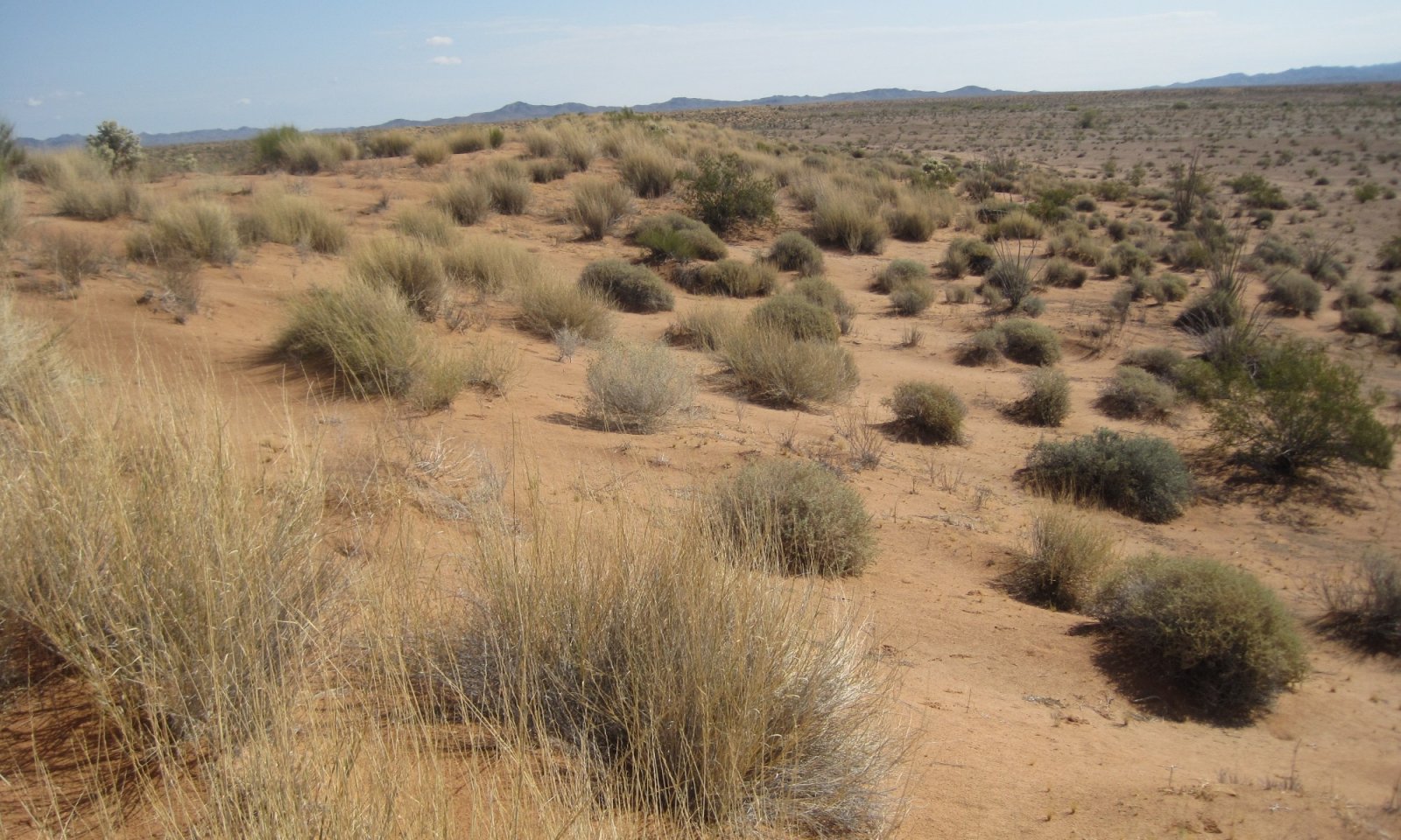
Sandy Slopes, Dunes, 3"-7" p.z., occurs on windblown (eolian) fine sands that form dunes greater than 10' in height with steep slopes (greater than 15%).
Associated sites
R040XC307AZ Limy Fan, Sandy 3"-7" p.z.
Interdune areas, windblown soils in sand sheets or small hummocks
Similar sites
R040XB232AZ Sandy Slopes, Dunes 7"-10" p.z.
Elevations 1,200' - 2,000' feet, more precipitation;
Table 1. Dominant plant species
Tree Not specified
Shrub (1) Ephedra nevadensis
(2) Ambrosia dumosaHerbaceous (1) Pleuraphis rigida
(2) Hesperocallis undulataPhysiographic features
This site occurs on dunes. Slopes are generally 15% percent or greater.
Table 2. Representative physiographic features
Landforms (1) Dune field
(2) Dune
Climatic features
Annual precipitation ranges from 3 to 7 inches. Annual rainfall is bimodal, with distinct rainy seasons occurring from December to March (winter) and July to September (summer). Rainfall ratios range from 40:60 (winter:summer). Rainfall intensity differs between rainfall seasons. Winter frontal storms develop in the Pacific Ocean and Gulf of California, producing widespread, low-intensity and long duration precipitation events. Winter precipitation is the more dependable water source for vegetation, and snowfall is very rare. During summer months, atmospheric activity in the Gulf of Mexico produces convective thunderstorms when crossing over the mountains in the afternoon. These storms travel across the plains and valleys, producing precipitation of short duration, usually less than 30 minutes, but of moderate to heavy intensity. However, these thunderstorms often produce little more than gusty winds and light showers. Between these two seasons, little to no effective precipitation can occur for several months at a time. May and June are the driest months, and overall humidity is very low.
Overall, average annual rainfall is variable, but increases in variability from east to west across the region. For long-term precipitation data, the coefficient of variation, the ratio of the standard deviation to the mean expressed as a percentage, increases from 44% at Gila Bend (east) to 65% at Mohawk (west).
Winter temperatures are very mild, with an average of 53°F in January, with recorded extremes of 10°F. Summertime temperatures are hot to very hot, averaging 93°F in July, and with recorded extremes of 125°F. Spring and summer growing seasons are equally important for perennial grass, forb and shrub and tree growth. With above average precipitation, cool and warm season annuals, forbs and grasses can be common in their respective seasons. Perennial forbs may only be visible above ground following rainfall events.Table 3 Representative climatic features
Frost-free period (characteristic range) 260-370 days Freeze-free period (characteristic range) 350-370 days Precipitation total (characteristic range) 0-10 in Frost-free period (actual range) 250-370 days Freeze-free period (actual range) 300-370 days Precipitation total (actual range) 0-10 in Frost-free period (average) 300 days Freeze-free period (average) 350 days Precipitation total (average) 10 in Characteristic rangeActual rangeBarLineFigure 1. Monthly precipitation range
Characteristic rangeActual rangeBarLineFigure 2. Monthly minimum temperature range
Characteristic rangeActual rangeBarLineFigure 3. Monthly maximum temperature range
BarLineFigure 4. Monthly average minimum and maximum temperature
Figure 5. Annual precipitation pattern
Figure 6 Annual average temperature pattern
Climate stations used
-
(1) YUMA PROVING GROUND [USW00003125], Yuma, AZ
-
(2) EHRENBERG 2 E [USC00022790], Cibola, AZ
-
(3) TACNA 3 NE [USC00028396], Roll, AZ
-
(4) GILA BEND [USC00023393], Gila Bend, AZ
-
(5) QUARTZSITE [USC00026865], Parker, AZ
">Influencing water features
Soil features
These soils form in deep, fine sands. Plant-soil moisture relationships are very good, as the subsoil moisture holding capacity exceeds moisture inputs, and that moisture is available to plants.
Table 4. Representative soil features
Surface texture (1) Fine sand
Family particle size (1) Sandy
Drainage class Excessively drained Permeability class Moderately rapid Soil depth 60 in Available water capacity
(0-40in)3.6 – 4.8 in Calcium carbonate equivalent
(0-40in)0 – 3 % Electrical conductivity
(0-40in)Not specified Sodium adsorption ratio
(0-40in)Not specified Soil reaction (1:1 water)
(0-40in)7.4 – 8.4 Ecological dynamics
Sandy Slopes, Dunes, 3"-7" p.z., supports a mixed plant community on wind-blown, fine sands. Two ecological states can occur, Grassland and Non-Native Annuals. Both are dominated by big galleta, with scattered shrubs and cactus. Trees are largely absent. Early spring growth of annual and perennial forbs can be highly productive following wet winters. The Non-native Annuals state may be difficult to observe in the field due to the early spring growing period, and Asian mustard, the predominant species, readily breaks up and disperses with wind. Fire is not a typical disturbance, though Non-native Annuals may carry a fire under the right fuel conditions. Lightning is an unlikely ignition source as Asian mustard biomass is typically dispersed prior to the occurrence of summer convective thunderstorms. Current field observations indicate burned areas are confined to roadsides. Plant-soil relationships are excellent. Aspect is desert shrub-grassland.
State and transition model
Custom diagramStandard diagram
More interactive model formats are also available. View Interactive Models
More interactive model formats are also available. View Interactive Models
Click on state and transition labels to scroll to the respective textEcosystem states
State 1 submodel, plant communities
State 2 submodel, plant communities
State 1
Grassland (Reference)
Figure 7. Sandy Slopes, Dunes 3"-7" p.z.
Grassland is a mixed desert plant community on wind-blown fine sands. The reference plant community is highly productive since all rainfall is captured and retained in the soil for long periods. Big galleta, jointfir and burrobush predominate, along with a variety of subshrubs and forbs. Cholla, creosotebush and ocotillo are widely scattered, mostly occurring on more stable summits, shoulders, and leeward side-slopes. Windward areas are unstable, with active windblown sands scouring large areas bare. Spring annuals and spring seasonal perennials (such as desert lily and birdcage evening primrose) flourish with sufficient winter precipitation.
Community 1.1
Desert Grass-Shrub
The plant community is a mixture of perennial and annual grasses, forbs and desert shrubs.
Figure 8. Annual production by plant type (representative values) or group (midpoint values)
Table 5. Annual production by plant type
Plant type Low
(lb/acre)Representative value
(lb/acre)High
(lb/acre)Grass/Grasslike 75 130 187 Forb 40 60 80 Shrub/Vine 0 12 25 Total 115 202 292 State 2
Non-native Annuals
Figure 9. Typical flourish of spring annuals. Asian mustard is visible in center-right.
Community 2.1
Asian Mustard-Grass-Shrub
Figure 10. Asian mustard flourished after wet winter. Dead stems present in all interspaces.
Non-native Annuals occurs primarily after Asian mustard seeds are introduced to the site. Asian mustard germinates early in the season, uses available moisture, and spreads a dense, low canopy that may impede germination and growth of native forbs. Other non-native annual forbs or grasses may be present but seem to not affect ecosystem dynamics as much as Asian mustard. Seed transport mechanisms are mechanical, either via wind-blown transport (the entire mature plant will tumble) or via animal transport of sticky (mucilaginous) seeds. Non-native Annuals will look much like Grassland for most of the year. During wet springs, Asian mustard will flourish, and the dead-standing plants may persist for a short time after the growing season. Currently, no management techniques have succeeded in removing Asian mustard and restoring Grassland.
Transition T1A
State 1 to 2
Grassland (Reference)
Non-native AnnualsSeed introduction via wind dispersal or mechanical transport.
Restoration pathway R2A
State 2 to 1
Non-native Annuals
Grassland (Reference)No known mechanism to remove non-native forbs.
Additional community tables
Table 6. Community 1.1 plant community composition
Group Common name Symbol Scientific name Annual production () Foliar cover (%) Grass/Grasslike1 Perennial Grass 33–188 big galleta PLRI3 Pleuraphis rigida 86–187 – 3 Annual Grasses 35–70 sixweeks threeawn ARAD Aristida adscensionis 0–10 – prairie threeawn AROL Aristida oligantha 0–10 – needle grama BOAR Bouteloua aristidoides 0–10 – sixweeks grama BOBA2 Bouteloua barbata 0–10 – witchgrass PACA6 Panicum capillare 0–10 – sixweeks fescue VUOC Vulpia octoflora 0–10 – Rothrock's grama BORO2 Bouteloua rothrockii 0–5 – Arizona brome BRAR4 Bromus arizonicus 0–1 – feather fingergrass CHVI4 Chloris virgata 0–1 – canyon cupgrass ERLE7 Eriochloa lemmonii 0–1 – tufted lovegrass ERPEP2 Eragrostis pectinacea var. pectinacea 0–1 – Mexican sprangletop LEFUU Leptochloa fusca ssp. uninervia 0–1 – mucronate sprangletop LEPA6 Leptochloa panicea 0–1 – Bigelow's bluegrass POBI Poa bigelovii 0–1 – Arizona signalgrass URAR Urochloa arizonica 0–1 – Forb4 Perennial Forbs 7–35 birdcage evening primrose OEDE2 Oenothera deltoides 2–7 – desert lily HEUN2 Hesperocallis undulata 2–7 – whitemargin sandmat CHAL11 Chamaesyce albomarginata 1–4 – desert sand verbena ABVI Abronia villosa 1–3 – desert marigold BAMU Baileya multiradiata 0–3 – desert twinbugs DICA4 Dicoria canescens 0–3 – canaigre dock RUHY Rumex hymenosepalus 0–1 – smooth threadleaf ragwort SEFLM Senecio flaccidus var. monoensis 0–1 – lacy tansyaster MAPIP4 Machaeranthera pinnatifida ssp. pinnatifida var. pinnatifida 0–1 – 5 Annual Forbs 35–70 desert Indianwheat PLOV Plantago ovata 0–10 – desert globemallow SPAM2 Sphaeralcea ambigua 0–5 – Coulter's globemallow SPCO2 Sphaeralcea coulteri 0–5 – common fiddleneck AMMEI2 Amsinckia menziesii var. intermedia 0–5 – bristly fiddleneck AMTE3 Amsinckia tessellata 0–5 – Booth's evening primrose CABOI Camissonia boothii ssp. intermedia 0–3 – chuckwalla combseed PEHE Pectocarya heterocarpa 0–3 – broadfruit combseed PEPL Pectocarya platycarpa 0–2 – wingnut cryptantha CRPT Cryptantha pterocarya 0–2 – hairy prairie clover DAMO Dalea mollis 0–1 – soft prairie clover DAMO2 Dalea mollissima 0–1 – California shieldpod DICA7 Dithyrea californica 0–1 – miniature woollystar ERDI2 Eriastrum diffusum 0–1 – woolly sunflower ERIOP2 Eriophyllum 0–1 – kidneyleaf buckwheat ERRE3 Eriogonum reniforme 0–1 – Thomas' buckwheat ERTH Eriogonum thomasii 0–1 – little deserttrumpet ERTR8 Eriogonum trichopes 0–1 – California poppy ESCAM Eschscholzia californica ssp. mexicana 0–1 – spurge EUPHO Euphorbia 0–1 – Arizona poppy KAGR Kallstroemia grandiflora 0–1 – Great Basin langloisia LASE3 Langloisia setosissima 0–1 – shaggyfruit pepperweed LELA Lepidium lasiocarpum 0–1 – Bigelow's linanthus LIBI2 Linanthus bigelovii 0–1 – foothill deervetch LOHU2 Lotus humistratus 0–1 – desert deervetch LOMI Lotus micranthus 0–1 – bajada lupine LUCO Lupinus concinnus 0–1 – Coulter's lupine LUSP2 Lupinus sparsiflorus 0–1 – onyxflower ACCO3 Achyronychia cooperi 0–1 – small wirelettuce STEX Stephanomeria exigua 0–1 – longbeak streptanthella STLO4 Streptanthella longirostris 0–1 – woolly tidestromia TILA2 Tidestromia lanuginosa 0–1 – manybristle chinchweed PEPA2 Pectis papposa 0–1 – desert unicorn-plant PRAL4 Proboscidea althaeifolia 0–1 – New Mexico plumeseed RANE Rafinesquia neomexicana 0–1 – California desertdandelion MACA6 Malacothrix californica 0–1 – yellowcomet MEAF2 Mentzelia affinis 0–1 – whitestem blazingstar MEAL6 Mentzelia albicaulis 0–1 – cottonheads NEDE Nemacaulis denudata 0–1 – glandular threadplant NEGL Nemacladus glanduliferus 0–1 – desert evening primrose OEPR Oenothera primiveris 0–1 – giant Spanish needle PAARG Palafoxia arida var. gigantea 0–1 – brittle spineflower CHBR Chorizanthe brevicornu 0–1 – Esteve's pincushion CHST Chaenactis stevioides 0–1 – Panamint cryptantha CRAN4 Cryptantha angustifolia 0–1 – redroot cryptantha CRMI Cryptantha micrantha 0–1 – New Mexico silverbush ARNE2 Argythamnia neomexicana 0–1 – Cedros milkvetch ASIN6 Astragalus insularis 0–1 – spiderling BOERH2 Boerhavia 0–1 – Shrub/Vine6 Shrubs 0–25 jointfir EPHED Ephedra 2–20 – ocotillo FOSP2 Fouquieria splendens 0–10 – burrobush AMDU2 Ambrosia dumosa 1–10 – white ratany KRGR Krameria grayi 0–8 – dyebush PSEM Psorothamnus emoryi 0–5 – creosote bush LATR2 Larrea tridentata 0–5 – 7 Cactus 7–35 blue paloverde PAFL6 Parkinsonia florida 5–15 – yellow paloverde PAMI5 Parkinsonia microphylla 5–15 – Table 7. Community 2.1 plant community composition
Group Common name Symbol Scientific name Annual production () Foliar cover (%) Interpretations
Supporting information
Other references
Griffith, G.E., Omernik, J.M., Johnson, C.B., and Turner, D.S., 2014, Ecoregions of Arizona (poster): U.S. Geological Survey Open-File Report 2014-1141, with map, scale 1:1,325,000, https://dx.doi.org/10.3133/ofr20141141. ISSN 2331-1258 (online)
United States Department of Agriculture, Natural Resources Conservation Service. 2006. Land Resource Regions and Major Land Resource Areas of the United States, the Caribbean, and the Pacific Basin. U.S. Department of Agriculture Handbook 296.Contributors
Wilma Renken
Approval
Kendra Moseley, 3/04/2025
Rangeland health reference sheet
Interpreting Indicators of Rangeland Health is a qualitative assessment protocol used to determine ecosystem condition based on benchmark characteristics described in the Reference Sheet. A suite of 17 (or more) indicators are typically considered in an assessment. The ecological site(s) representative of an assessment location must be known prior to applying the protocol and must be verified based on soils and climate. Current plant community cannot be used to identify the ecological site.
Author(s)/participant(s) Contact for lead author Date 10/22/2019 Approved by Approval date Composition (Indicators 10 and 12) based on Annual Production Indicators
-
Number and extent of rills:
-
Presence of water flow patterns:
-
Number and height of erosional pedestals or terracettes:
-
Bare ground from Ecological Site Description or other studies (rock, litter, lichen, moss, plant canopy are not bare ground):
-
Number of gullies and erosion associated with gullies:
-
Extent of wind scoured, blowouts and/or depositional areas:
-
Amount of litter movement (describe size and distance expected to travel):
-
Soil surface (top few mm) resistance to erosion (stability values are averages - most sites will show a range of values):
-
Soil surface structure and SOM content (include type of structure and A-horizon color and thickness):
-
Effect of community phase composition (relative proportion of different functional groups) and spatial distribution on infiltration and runoff:
-
Presence and thickness of compaction layer (usually none; describe soil profile features which may be mistaken for compaction on this site):
-
Functional/Structural Groups (list in order of descending dominance by above-ground annual-production or live foliar cover using symbols: >>, >, = to indicate much greater than, greater than, and equal to):
Dominant:
Sub-dominant:
Other:
Additional:
-
Amount of plant mortality and decadence (include which functional groups are expected to show mortality or decadence):
-
Average percent litter cover (%) and depth ( in):
-
Expected annual annual-production (this is TOTAL above-ground annual-production, not just forage annual-production):
-
Potential invasive (including noxious) species (native and non-native). List species which BOTH characterize degraded states and have the potential to become a dominant or co-dominant species on the ecological site if their future establishment and growth is not actively controlled by management interventions. Species that become dominant for only one to several years (e.g., short-term response to drought or wildfire) are not invasive plants. Note that unlike other indicators, we are describing what is NOT expected in the reference state for the ecological site:
-
Perennial plant reproductive capability:
Print Options
Sections
Font
AAAAOther
PrintThe Ecosystem Dynamics Interpretive Tool is an information system framework developed by the USDA-ARS Jornada Experimental Range, USDA Natural Resources Conservation Service, and New Mexico State University.
Accessibility statement


