
Natural Resources
Conservation Service
Ecological site R040XB233AZ
Limy Slopes, Gypsum
7"-10" p.z.
Last updated: 10/17/2024
Accessed: 10/15/2026
-
Search


Major Land Resource Area or ecological site by name and/or ID.
PreviousSectionsNextGeneral information
Provisional. A provisional ecological site description has undergone quality control and quality assurance review. It contains a working state and transition model and enough information to identify the ecological site.
MLRA notes
Major Land Resource Area (MLRA): 040X–Sonoran Basin and Range
Major Land Resource Area (MLRA) 40 is the portion of Sonoran Desert that extends from northwest Mexico into southwestern Arizona and southeastern California. This MLRA is hot desert characterized by bimodal precipitation coupled with hot summers and mild winters. These conditions give rise to a rich biological diversity visually dominated by columnar cactus (saguaro) and leguminous trees (palo verde). This unit occurs within the Basin and Range Physiographic Province and is characterized by numerous mountain ranges that rise abruptly from broad, plain-like valleys and basins. Igneous and metamorphic rock classes dominate the mountain ranges, and basin sediments are combinations of fluvial, lacustrine, colluvial and alluvial deposits.
LRU notes
Land Resource Unit (LRU) 40-2, Middle Sonoran Desert, is characterized by desert scrub vegetation on relict fan remnants with a moderate amount of desert pavement. Trees are common in washes, bottoms and hillslopes. Elevations range from 1200 to 2000 feet, and precipitation averages 7 to 10 inches per year. Vegetation includes saguaro, palo verde, creosotebush, triangle bursage, brittlebush, prickly pear, cholla, desert saltbush, wolfberry bush muhly, threeawns, and big galleta. The soil temperature regime is hyperthermic and the soil moisture regime is typic aridic.
Classification relationships
USDA-NRCS Land Resource Regions and Major Land Resource Areas of the United States, the Caribbean, and the Pacific Basin: Western Range and Irrigated Region D Major Land Resource Area 40 - Sonoran Basin and Range Land Resource Unit 2 - Middle Sonoran Desert Ecological Site Limy Slopes, Gypsum, 7"-10" p.z.
U.S. Environmental Protection Agency, Ecological Regions of North America: Level I, Region 10 North American Deserts Level II, 10.2 Warm Deserts Level III, Ecoregion 81, Sonoran Basin and Range Level IV, 81l, 81n, 81o
USDA-USFS Ecological Subregions: Sections of the Conterminous United States Section 322 American Semidesert and Desert Province Section 322B, Sonoran DesertEcological site concept
Limy Slopes, Gypsum, 7"-10" p.z., occurs on moderately to steeply sloping uplands. Slopes are generally greater than 8%. The calcareous soils are deep with visible gypsum crystals. The gypsum content, combined with the steep slopes, make this ecological site extremely susceptible to water erosion, affecting use and management options.
Associated sites
R040XB234AZ Limy Fan, Gypsum 7" -10" p.z.
adjacent alluvial fans
Similar sites
R040XB209AZ Limy Slopes 7"-10" p.z.
soils not gypsic
Table 1. Dominant plant species
Tree Not specified
Shrub (1) Ambrosia dumosa
(2) Larrea tridentataHerbaceous (1) Pleuraphis rigida
Physiographic features
This site occurs on hillslopes and ridgetops generally associated with relict lakebed sediments.
Table 2. Representative physiographic features
Landforms (1) Hill
(2) Ridge
Elevation 1200 – 2000 ft Slope 8 – 45 % Climatic features
Annual precipitation ranges from 7 to 10 inches. Annual rainfall is bimodal, with distinct rainy seasons occurring from December to March (winter) and July to September (summer). Rainfall ratios range from 40:60 (winter:summer) in the southern part, and 60:40 in the central and northern parts. Rainfall intensity differs between rainfall seasons. Winter frontal storms develop in the Pacific Ocean and Gulf of California, producing widespread, low-intensity and long duration precipitation events. Winter precipitation is the more dependable water source for vegetation, and snowfall is very rare. During summer months, atmospheric activity in the Gulf of Mexico produces convective thunderstorms when crossing over the mountains in the afternoon. These storms travel across the plains and valleys, producing precipitation of short duration, usually less than 30 minutes, but of moderate to heavy intensity. Between these two seasons, little to no effective precipitation can occur for several months at a time. May and June are the driest months, and overall humidity is very low. Overall, average annual rainfall is variable, but increases in variability from east to west across the region. For long-term precipitation data, the coefficient of variation, the ratio of the standard deviation to the mean expressed as a percentage, increases from 38% at Florence (east) to 46% at Aguila (west).
Winter temperatures are very mild, with very few days having short periods of freezing temperatures. Summertime temperatures are hot to very hot, with many days in June and July exceeding 105°F. The number of frost-free days ranges from 280 in major river valleys with cold air drainage to between 320 and 350 in upland areas.
Spring and summer growing seasons are equally important for perennial grass, forb and shrub growth. With above average precipitation, cool and warm season annual forbs and grasses can be common in their respective seasons. Perennial forage species can remain green throughout the year with sufficient available moisture.Table 3 Representative climatic features
Frost-free period (average) 290 days Freeze-free period (average) 340 days Precipitation total (average) 10 in BarLineFigure 1. Monthly precipitation range
BarLineFigure 2. Monthly average minimum and maximum temperature
">Influencing water features
Soil features
These are moderately deep to deep soils formed in relict lakebed deposits. They are very calcareous and gypsiferous, with greater than 15% gypsum content throughout the soil profile. Fine gypsum masses and fine gypsum crystals are visible in subsoils. The gypsum content makes the soil extremely vulnerable to water erosion. Plant-soil moisture relationships are poor.
Table 4. Representative soil features
Parent material (1) Lacustrine deposits
Drainage class Well drained Permeability class Moderate to moderately rapid Soil depth 40 – 60 in Surface fragment cover <=3" 15 – 65 % Surface fragment cover >3" 1 – 10 % Available water capacity
(0-40in)3 – 6 in Calcium carbonate equivalent
(0-40in)5 – 35 % Electrical conductivity
(0-40in)0 – 2 mmhos/cm Sodium adsorption ratio
(0-40in)Not specified Soil reaction (1:1 water)
(0-40in)7.9 – 8.4 Subsurface fragment volume <=3"
(Depth not specified)15 – 65 % Subsurface fragment volume >3"
(Depth not specified)1 – 10 % Ecological dynamics
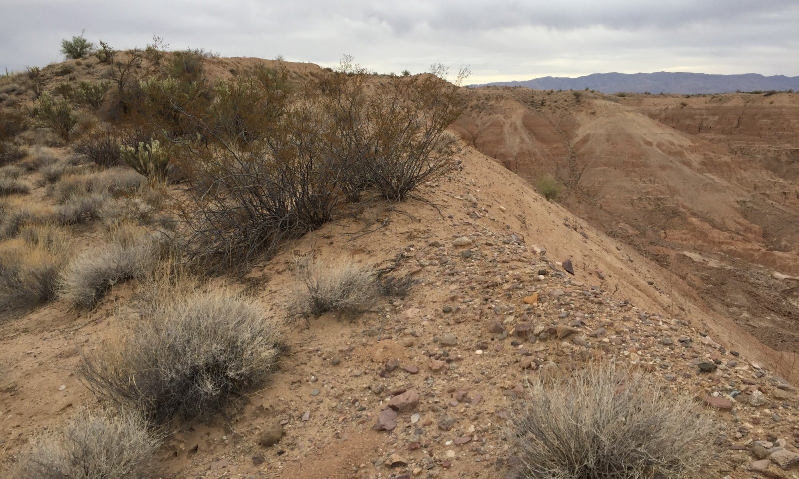
Limy Slopes, Gypsum, 7"-10" p.z., is a robust ecological site of limited areal extent. Only one state, Shrubland, has been observed. The soil gypsum content makes the site extremely vulnerable to water erosion. Any disturbance that removes the surface horizon could initiate extreme erosion. Areas of geological erosion are located adjacent to this ecological site (Figure 4). These barren areas are not caused by human disturbance, thus, are not considered to represent a separate state.
State and transition model
Custom diagramStandard diagram
More interactive model formats are also available. View Interactive Models
More interactive model formats are also available. View Interactive Models
Click on state and transition labels to scroll to the respective textEcosystem states
State 1 submodel, plant communities
State 1
Shrubland (Reference)Community 1.1
Creosote-Bursage-Mixed Shrub
Figure 3. Reference community on left, eroded slopes on right
The potential plant community on this site is a mixture of desert shrubs, cacti, perennial grasses and forbs. Annual grasses and forbs make up a small percentage of the potential community. The aspect is shrubland.
Figure 4. Annual production by plant type (representative values) or group (midpoint values)
Table 5. Annual production by plant type
Plant type Low
(lb/acre)Representative value
(lb/acre)High
(lb/acre)Shrub/Vine 195 225 255 Grass/Grasslike 15 30 45 Forb 30 37 45 Total 240 292 345 Additional community tables
Table 6. Community 1.1 plant community composition
Group Common name Symbol Scientific name Annual production () Foliar cover (%) Grass/Grasslike1 Perennial Grasses 15–30 big galleta PLRI3 Pleuraphis rigida 0–15 – bush muhly MUPO2 Muhlenbergia porteri 0–5 – spidergrass ARTE3 Aristida ternipes 0–1 – low woollygrass DAPU7 Dasyochloa pulchella 0–1 – 2 Annual Grasses 3–15 needle grama BOAR Bouteloua aristidoides 0–5 – Rothrock's grama BORO2 Bouteloua rothrockii 0–5 – Arizona brome BRAR4 Bromus arizonicus 0–1 – feather fingergrass CHVI4 Chloris virgata 0–1 – Arizona signalgrass URAR Urochloa arizonica 0–1 – Forb4 Perennial Forbs 15–30 desert globemallow SPAM2 Sphaeralcea ambigua 5–10 – desert trumpet ERIN4 Eriogonum inflatum 2–5 – Parry's false prairie-clover MAPA7 Marina parryi 0–2 – lacy tansyaster MAPIP4 Machaeranthera pinnatifida ssp. pinnatifida var. pinnatifida 0–2 – rough menodora MESC Menodora scabra 0–1 – evening primrose OENOT Oenothera 0–1 – slender poreleaf POGR5 Porophyllum gracile 0–1 – Coues' cassia SECO10 Senna covesii 0–1 – California fagonbush FALA Fagonia laevis 0–1 – paleface HIDE Hibiscus denudatus 0–1 – slender janusia JAGR Janusia gracilis 0–1 – dwarf desertpeony ACNA2 Acourtia nana 0–1 – brownfoot ACWR5 Acourtia wrightii 0–1 – poreleaf dogweed ADPO2 Adenophyllum porophyllum 0–1 – trailing windmills ALIN Allionia incarnata 0–1 – narrowleaf silverbush ARLA12 Argythamnia lanceolata 0–1 – New Mexico silverbush ARNE2 Argythamnia neomexicana 0–1 – rush milkweed ASSU Asclepias subulata 0–1 – desert marigold BAMU Baileya multiradiata 0–1 – whitemargin sandmat CHAL11 Chamaesyce albomarginata 0–1 – desert larkspur DEPA Delphinium parishii 0–1 – tall mountain larkspur DESC Delphinium scaposum 0–1 – bluedicks DICA14 Dichelostemma capitatum 0–1 – brownplume wirelettuce STPA4 Stephanomeria pauciflora 0–1 – 5 Annual Forbs 3–15 sand pygmyweed CRCO34 Crassula connata 0–3 – combseed PECTO Pectocarya 0–3 – woolly tidestromia TILA2 Tidestromia lanuginosa 0–3 – coastal bird's-foot trefoil LOSAB Lotus salsuginosus var. brevivexillus 0–2 – strigose bird's-foot trefoil LOSTT Lotus strigosus var. tomentellus 0–2 – cryptantha CRYPT Cryptantha 0–2 – hairy prairie clover DAMO Dalea mollis 0–1 – American wild carrot DAPU3 Daucus pusillus 0–1 – western tansymustard DEPI Descurainia pinnata 0–1 – flatcrown buckwheat ERDE6 Eriogonum deflexum 0–1 – miniature woollystar ERDI2 Eriastrum diffusum 0–1 – erigenia ERIGE Erigenia 0–1 – buckwheat ERIOG Eriogonum 0–1 – Texas stork's bill ERTE13 Erodium texanum 0–1 – California poppy ESCAM Eschscholzia californica ssp. mexicana 0–1 – pygmy poppy ESMI Eschscholzia minutiflora 0–1 – gilia GILIA Gilia 0–1 – Gordon's bladderpod LEGO Lesquerella gordonii 0–1 – shaggyfruit pepperweed LELA Lepidium lasiocarpum 0–1 – foothill deervetch LOHU2 Lotus humistratus 0–1 – Arizona lupine LUAR4 Lupinus arizonicus 0–1 – Coulter's lupine LUSP2 Lupinus sparsiflorus 0–1 – blazingstar MENTZ Mentzelia 0–1 – bristly nama NAHI Nama hispidum 0–1 – glandular threadplant NEGL Nemacladus glanduliferus 0–1 – Florida pellitory PAFL3 Parietaria floridana 0–1 – manybristle chinchweed PEPA2 Pectis papposa 0–1 – phacelia PHACE Phacelia 0–1 – desert Indianwheat PLOV Plantago ovata 0–1 – New Mexico plumeseed RANE Rafinesquia neomexicana 0–1 – chia SACO6 Salvia columbariae 0–1 – sleepy silene SIAN2 Silene antirrhina 0–1 – Coulter's globemallow SPCO2 Sphaeralcea coulteri 0–1 – woollyhead neststraw STMI2 Stylocline micropoides 0–1 – common fiddleneck AMMEI2 Amsinckia menziesii var. intermedia 0–1 – bristly fiddleneck AMTE3 Amsinckia tessellata 0–1 – milkvetch ASTRA Astragalus 0–1 – Esteve's pincushion CHST Chaenactis stevioides 0–1 – New Mexico thistle CINE Cirsium neomexicanum 0–1 – Coulter's spiderling BOCO2 Boerhavia coulteri 0–1 – hoary bowlesia BOIN3 Bowlesia incana 0–1 – California suncup CACA32 Camissonia californica 0–1 – exserted Indian paintbrush CAEXE Castilleja exserta ssp. exserta 0–1 – yellow tackstem CAPA7 Calycoseris parryi 0–1 – white tackstem CAWR Calycoseris wrightii 0–1 – brittle spineflower CHBR Chorizanthe brevicornu 0–1 – pebble pincushion CHCA Chaenactis carphoclinia 0–1 – hyssopleaf sandmat CHHY3 Chamaesyce hyssopifolia 0–1 – devil's spineflower CHRI Chorizanthe rigida 0–1 – Shrub/Vine6 Dominant Large Shrub 90–135 creosote bush LATR2 Larrea tridentata 90–135 – 7 Dominant Half Shrubs 20–45 burrobush AMDU2 Ambrosia dumosa 15–30 – white ratany KRGR Krameria grayi 5–15 – brittlebush ENFA Encelia farinosa 0–5 – 9 Miscellaneous Shrubs 15–30 yellow paloverde PAMI5 Parkinsonia microphylla 0–5 – desert ironwood OLTE Olneya tesota 0–3 – ocotillo FOSP2 Fouquieria splendens 0–2 – desert lavender HYEM Hyptis emoryi 0–1 – sangre de cristo JACA2 Jatropha cardiophylla 0–1 – crown of thorns KOSP Koeberlinia spinosa 0–1 – water jacket LYAN Lycium andersonii 0–1 – Arizona desert-thorn LYEX Lycium exsertum 0–1 – desert wolfberry LYMA Lycium macrodon 0–1 – whitethorn acacia ACCO2 Acacia constricta 0–1 – catclaw acacia ACGR Acacia greggii 0–1 – rayless goldenhead ACSP Acamptopappus sphaerocephalus 0–1 – Coulter's brickellbush BRCO Brickellia coulteri 0–1 – button brittlebush ENFR Encelia frutescens 0–1 – Nevada jointfir EPNE Ephedra nevadensis 0–1 – velvet mesquite PRVE Prosopis velutina 0–1 – whitestem paperflower PSCO2 Psilostrophe cooperi 0–1 – dwarf saltwort SABI Salicornia bigelovii 0–1 – Mexican bladdersage SAME Salazaria mexicana 0–1 – jojoba SICH Simmondsia chinensis 0–1 – woody crinklemat TICAC Tiquilia canescens var. canescens 0–1 – American threefold TRCA8 Trixis californica 0–1 – Parish's goldeneye VIPA14 Viguiera parishii 0–1 – desert zinnia ZIAC Zinnia acerosa 0–1 – lotebush ZIOB Ziziphus obtusifolia 0–1 – 10 Cacti 15–30 senita cactus PASC14 Pachycereus schottii 0–2 – organpipe cactus STTH3 Stenocereus thurberi 0–2 – beavertail pricklypear OPBA2 Opuntia basilaris 0–1 – Engelmann's hedgehog cactus ECEN Echinocereus engelmannii 0–1 – Leconte's barrel cactus FECYL Ferocactus cylindraceus var. lecontei 0–1 – candy barrelcactus FEWI Ferocactus wislizeni 0–1 – common fishhook cactus MATE4 Mammillaria tetrancistra 0–1 – Interpretations
Supporting information
Other references
Griffith, G.E., Omernik, J.M., Johnson, C.B., and Turner, D.S., 2014, Ecoregions of Arizona (poster): U.S. Geological Survey Open-File Report 2014-1141, with map, scale 1:1,325,000, https://dx.doi.org/10.3133/ofr20141141. ISSN 2331-1258 (online)
United States Department of Agriculture, Natural Resources Conservation Service. 2006. Land Resource Regions and Major Land Resource Areas of the United States, the Caribbean, and the Pacific Basin. U.S. Department of Agriculture Handbook 296.Contributors
Wilma Renken
Approval
Kendra Moseley, 10/17/2024
Rangeland health reference sheet
Interpreting Indicators of Rangeland Health is a qualitative assessment protocol used to determine ecosystem condition based on benchmark characteristics described in the Reference Sheet. A suite of 17 (or more) indicators are typically considered in an assessment. The ecological site(s) representative of an assessment location must be known prior to applying the protocol and must be verified based on soils and climate. Current plant community cannot be used to identify the ecological site.
Author(s)/participant(s) Contact for lead author Date 10/22/2019 Approved by Approval date Composition (Indicators 10 and 12) based on Annual Production Indicators
-
Number and extent of rills:
-
Presence of water flow patterns:
-
Number and height of erosional pedestals or terracettes:
-
Bare ground from Ecological Site Description or other studies (rock, litter, lichen, moss, plant canopy are not bare ground):
-
Number of gullies and erosion associated with gullies:
-
Extent of wind scoured, blowouts and/or depositional areas:
-
Amount of litter movement (describe size and distance expected to travel):
-
Soil surface (top few mm) resistance to erosion (stability values are averages - most sites will show a range of values):
-
Soil surface structure and SOM content (include type of structure and A-horizon color and thickness):
-
Effect of community phase composition (relative proportion of different functional groups) and spatial distribution on infiltration and runoff:
-
Presence and thickness of compaction layer (usually none; describe soil profile features which may be mistaken for compaction on this site):
-
Functional/Structural Groups (list in order of descending dominance by above-ground annual-production or live foliar cover using symbols: >>, >, = to indicate much greater than, greater than, and equal to):
Dominant:
Sub-dominant:
Other:
Additional:
-
Amount of plant mortality and decadence (include which functional groups are expected to show mortality or decadence):
-
Average percent litter cover (%) and depth ( in):
-
Expected annual annual-production (this is TOTAL above-ground annual-production, not just forage annual-production):
-
Potential invasive (including noxious) species (native and non-native). List species which BOTH characterize degraded states and have the potential to become a dominant or co-dominant species on the ecological site if their future establishment and growth is not actively controlled by management interventions. Species that become dominant for only one to several years (e.g., short-term response to drought or wildfire) are not invasive plants. Note that unlike other indicators, we are describing what is NOT expected in the reference state for the ecological site:
-
Perennial plant reproductive capability:
Print Options
Sections
Font
AAAAOther
PrintThe Ecosystem Dynamics Interpretive Tool is an information system framework developed by the USDA-ARS Jornada Experimental Range, USDA Natural Resources Conservation Service, and New Mexico State University.
Accessibility statement


