
Natural Resources
Conservation Service
Ecological site R040XB231AZ
Lithic Hills
7"-10" p.z.
Last updated: 10/17/2024
Accessed: 10/17/2026
-
Search


Major Land Resource Area or ecological site by name and/or ID.
PreviousSectionsNextGeneral information
Provisional. A provisional ecological site description has undergone quality control and quality assurance review. It contains a working state and transition model and enough information to identify the ecological site.
MLRA notes
Major Land Resource Area (MLRA): 040X–Sonoran Basin and Range
Major Land Resource Area (MLRA) 40 is the portion of Sonoran Desert that extends from northwest Mexico into southwestern Arizona and southeastern California. This MLRA is hot desert characterized by bimodal precipitation coupled with hot summers and mild winters. These conditions give rise to a rich biological diversity visually dominated by columnar cactus (saguaro) and leguminous trees (palo verde). This unit occurs within the Basin and Range Physiographic Province and is characterized by numerous mountain ranges that rise abruptly from broad, plain-like valleys and basins. Igneous and metamorphic rock classes dominate the mountain ranges, and basin sediments are combinations of fluvial, lacustrine, colluvial and alluvial deposits.
LRU notes
Land Resource Unit (LRU) 40-2, Middle Sonoran Desert, is characterized by desert scrub vegetation. A moderate amount of desert pavement is present on fan remnants. Trees are common in washes, bottoms and hillslopes. Elevations range from 1200 to 2000 feet, and precipitation averages 7 to 10 inches per year. Vegetation includes saguaro, palo verde, creosotebush, triangle bursage, brittlebush, prickly pear, cholla, desert saltbush, wolfberry bush muhly, threeawns, and big galleta. The soil temperature regime is hyperthermic and the soil moisture regime is typic aridic.
Classification relationships
USDA-NRCS Land Resource Regions and Major Land Resource Areas of the United States, the Caribbean, and the Pacific Basin: Western Range and Irrigated Region D Major Land Resource Area 40 - Sonoran Basin and Range Land Resource Unit 2 - Middle Sonoran Desert Ecological Site Lithic Hills, 7"-10" p.z.
U.S. Environmental Protection Agency, Ecological Regions of North America: Level I, Region 10 North American Deserts Level II, 10.2 Warm Deserts Level III, Ecoregion 81, Sonoran Basin and Range Level IV, 81l, 81n, 81o
USDA-USFS Ecological Subregions: Sections of the Conterminous United States Section 322 American Semidesert and Desert Province Section 322B, Sonoran DesertEcological site concept
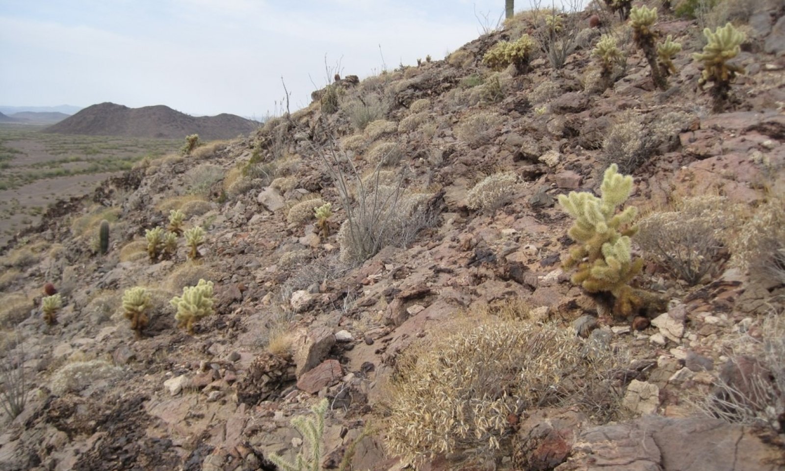
Lithic Hills, 7"-10" p.z., occur on steep terrain, with slopes greater than 15%. Soils are calcareous, loamy textured, and very shallow to shallow over hard, unweathered bedrock. Exposed bedrock often covers more than 20% of the surface area. This ecological site was renamed from Limestone Hills, 7"-10" p.z., as parent materials are not limited to limestone.
Associated sites
R040XB216AZ Sandy Wash 7"-10" p.z.
Sandy Wash ecological site benefits from run-off originating on Lithic Hills
R040XB208AZ Limy Upland, Deep 7"-10" p.z.
Limy Upland Deep ecological site situated on uplands below Lithic Hills
R040XB210AZ Limy Upland 7"-10" p.z.
Limy Upland ecological site situated on upland below Lithic Hills
Similar sites
R040XB210AZ Limy Upland 7"-10" p.z.
Table 1. Dominant plant species
Tree Not specified
Shrub (1) Encelia farinosa
(2) Cylindropuntia bigeloviiHerbaceous Not specified
Physiographic features
This site occurs on steep hill-slopes and ridge-tops. Rock outcrops can cover more than 20% of the area.
Table 2. Representative physiographic features
Landforms (1) Mountain
(2) Hill
(3) Mountain slope
Flooding frequency None Ponding frequency None Elevation 1200 – 2000 ft Slope 15 – 75 % Aspect Aspect is not a significant factor Climatic features
Annual precipitation ranges from 7 to 10 inches. Annual rainfall is bimodal, with distinct rainy seasons occurring from December to March (winter) and July to September (summer). Rainfall ratios range from 40:60 (winter:summer) in the southern part, and 60:40 in the central and northern parts. Rainfall intensity differs between rainfall seasons. Winter frontal storms develop in the Pacific Ocean and Gulf of California, producing widespread, low-intensity and long duration precipitation events. Winter precipitation is the most dependable water source for vegetation, and snowfall is very rare. During summer months, atmospheric activity in the Gulf of Mexico produces convective thunderstorms when crossing over the mountains in the afternoon. These storms travel across the plains and valleys, producing precipitation of short duration, usually less than 30 minutes, but of moderate to heavy intensity. Between these two seasons, little to no effective precipitation can occur for several months at a time. May and June are the driest months, and overall humidity is very low.
Overall, average annual rainfall is variable, but increases in variability from east to west across the region. For long-term precipitation data, the coefficient of variation, the ratio of the standard deviation to the mean expressed as a percentage, increases from 38% at Florence (east) to 46% at Aguila (west).
Winter temperatures are very mild, with very few days having short periods of freezing temperatures. Summertime temperatures are hot to very hot, with many days in June and July exceeding 105°F. The number of frost-free days ranges from 280 in major river valleys with cold air drainage to between 320 and 350 in upland areas.
Spring and the summer growing seasons are equally important for perennial grass, forb and shrub growth. With above average precipitation, cool and warm season annual forbs and grasses can be common in their respective seasons. Perennial forage species can remain green throughout the year with sufficient available moisture.Table 3 Representative climatic features
Frost-free period (average) 290 days Freeze-free period (average) 340 days Precipitation total (average) 10 in BarLineFigure 1. Monthly precipitation range
BarLineFigure 2. Monthly average minimum and maximum temperature
">Influencing water features
Soil features
These shallow and very shallow soils form over bedrock. Parent material varies from sedimentary to igneous sources. Soils are calcareous throughout, and are very gravelly to cobbly. Plant-soil moisture relationships are poor, though the large rock outcrops concentrate precipitation to areas with soil.
Table 4. Representative soil features
Surface texture (1) Very gravelly sandy loam
(2) Gravelly sandy loam
(3) Gravelly loam
Family particle size (1) Loamy
Drainage class Somewhat excessively drained Permeability class Rapid to moderately rapid Soil depth 5 – 20 in Surface fragment cover <=3" 30 – 60 % Surface fragment cover >3" 5 – 20 % Available water capacity
(0-40in)0.5 – 2 in Calcium carbonate equivalent
(0-40in)0 – 20 % Electrical conductivity
(0-40in)0 – 2 mmhos/cm Sodium adsorption ratio
(0-40in)0 – 2 Soil reaction (1:1 water)
(0-40in)7.9 – 8.4 Subsurface fragment volume <=3"
(Depth not specified)35 – 65 % Subsurface fragment volume >3"
(Depth not specified)0 – 10 % Ecological dynamics
The potential plant community is a diverse mixture of desert trees, shrubs, cacti, half-shrubs and shrub-like perennial forbs. Drought conditions frequently occur. The sparse plant community and exposed bedrock effectively eliminate the occurrence of fire. The shallow, course-textured soils dry very quickly, greatly limiting the occurrence of shallow-rooted perennials. Rainfall infiltrates cracks in the bedrock, and plants become deeply rooted within these cracks. Shrubland is the only ecological state for this site. Plant-soil moisture relationships are poor. The aspect is open shrubland.
State and transition model
Custom diagramStandard diagram
More interactive model formats are also available. View Interactive Models
More interactive model formats are also available. View Interactive Models
Click on state and transition labels to scroll to the respective textEcosystem states
State 1 submodel, plant communities
State 1
ShrublandCommunity 1.1
Shrub-Cactus
The potential plant community is a diverse mixture of desert trees, shrubs, cacti, and perennial grasses and forbs. The large amount of rock outcrop on this site tends to concentrate precipitation onto adjacent soil areas. Brittlebush predominates on north-facing slopes while teddybear cholla predominates on south-facing slopes. Plant populations of range from 110 to 150 individuals per acre for brittlebush, 200 to 250 for teddybear cholla, 50 to 100 for creosotebush, 35 to 50 for ocotillo, and 1 to 10 for saguaro. Cryptogam cover on bare ground ranges from low to moderate. Plant-soil moisture relationships are poor. The aspect is shrubland.
Figure 3. Annual production by plant type (representative values) or group (midpoint values)
Table 5. Annual production by plant type
Plant type Low
(lb/acre)Representative value
(lb/acre)High
(lb/acre)Shrub/Vine 100 225 345 Forb 10 12 25 Grass/Grasslike 0 2 10 Total 110 239 380 Table 6. Soil surface cover
Tree basal cover 0-0% Shrub/vine/liana basal cover 0-0% Grass/grasslike basal cover 0-0% Forb basal cover 0-0% Non-vascular plants 0% Biological crusts 0-20% Litter 0-20% Surface fragments >0.25" and <=3" 30-60% Surface fragments >3" 10-30% Bedrock 20-60% Water 0% Bare ground 10-30% Table 7. Canopy structure (% cover)
Height Above Ground (ft) Tree Shrub/Vine Grass/
GrasslikeForb <0.5 – 0-2% 0-10% 1-10% >0.5 <= 1 – 0-2% 1-5% 1-10% >1 <= 2 – 1-5% 0-1% 0-2% >2 <= 4.5 0-1% 1-5% 0-1% 0-1% >4.5 <= 13 5-10% – – – >13 <= 40 0-1% – – – >40 <= 80 – – – – >80 <= 120 – – – – >120 – – – – Additional community tables
Table 8. Community 1.1 plant community composition
Group Common name Symbol Scientific name Annual production () Foliar cover (%) Grass/Grasslike1 Miscellaneous perennial grasses 0–5 slim tridens TRMU Tridens muticus 0–2 – Parish's threeawn ARPUP5 Aristida purpurea var. parishii 0–2 – Wright's threeawn ARPUW Aristida purpurea var. wrightii 0–2 – spidergrass ARTE3 Aristida ternipes 0–2 – cane bluestem BOBA3 Bothriochloa barbinodis 0–2 – Arizona cottontop DICA8 Digitaria californica 0–2 – desert needlegrass ACSP12 Achnatherum speciosum 0–2 – Havard's threeawn ARHA3 Aristida havardii 0–2 – 2 Annual grasses 0–45 sixweeks threeawn ARAD Aristida adscensionis 0–10 – Rothrock's grama BORO2 Bouteloua rothrockii 0–10 – sixweeks fescue VUOC Vulpia octoflora 0–10 – prairie threeawn AROL Aristida oligantha 0–5 – delicate muhly MUFR Muhlenbergia fragilis 0–3 – Arizona signalgrass URAR Urochloa arizonica 0–2 – desert lovegrass ERPEM Eragrostis pectinacea var. miserrima 0–2 – Arizona brome BRAR4 Bromus arizonicus 0–1 – needle grama BOAR Bouteloua aristidoides 0–1 – sixweeks grama BOBA2 Bouteloua barbata 0–1 – Forb3 Dominant perennial forbs 10–50 California fagonbush FALA Fagonia laevis 1–5 – slender poreleaf POGR5 Porophyllum gracile 1–5 – desert trumpet ERIN4 Eriogonum inflatum 1–5 – trailing windmills ALIN Allionia incarnata 0–5 – desert globemallow SPAM2 Sphaeralcea ambigua 1–5 – slender janusia JAGR Janusia gracilis 0–5 – Coues' cassia SECO10 Senna covesii 0–3 – brownplume wirelettuce STPA4 Stephanomeria pauciflora 0–2 – plains blackfoot MELE2 Melampodium leucanthum 0–1 – scarlet spiderling BOCO Boerhavia coccinea 0–1 – Parry's beardtongue PEPA24 Penstemon parryi 0–1 – rosemallow HIBIS2 Hibiscus 0–1 – paleface HIDE Hibiscus denudatus 0–1 – narrowleaf silverbush ARLA12 Argythamnia lanceolata 0–1 – glandleaf milkwort POMA7 Polygala macradenia 0–1 – desert marigold BAMU Baileya multiradiata 0–1 – leatherweed CRPOP Croton pottsii var. pottsii 0–1 – dense ayenia AYMI Ayenia microphylla 0–1 – New Mexico silverbush ARNE2 Argythamnia neomexicana 0–1 – weakleaf bur ragweed AMCO3 Ambrosia confertiflora 0–1 – 4 Annual forbs and minor perennials 1–65 phacelia PHACE Phacelia 0–15 – desert Indianwheat PLOV Plantago ovata 0–10 – lyreleaf jewelflower STCA5 Streptanthus carinatus 0–10 – western tansymustard DEPI Descurainia pinnata 0–10 – cryptantha CRYPT Cryptantha 0–10 – California poppy ESCAM Eschscholzia californica ssp. mexicana 0–10 – Gordon's bladderpod LEGO Lesquerella gordonii 0–10 – Coulter's lupine LUSP2 Lupinus sparsiflorus 0–10 – exserted Indian paintbrush CAEXE Castilleja exserta ssp. exserta 0–10 – shaggyfruit pepperweed LELA Lepidium lasiocarpum 0–5 – hairy prairie clover DAMO Dalea mollis 0–5 – Texas stork's bill ERTE13 Erodium texanum 0–5 – chia SACO6 Salvia columbariae 0–2 – wishbone-bush MILAV Mirabilis laevis var. villosa 0–2 – Florida pellitory PAFL3 Parietaria floridana 0–1 – whitestem blazingstar MEAL6 Mentzelia albicaulis 0–1 – foothill deervetch LOHU2 Lotus humistratus 0–1 – Mexican fireplant EUHE4 Euphorbia heterophylla 0–1 – Parish's larkspur DEPAP3 Delphinium parishii ssp. parishii 0–1 – flatcrown buckwheat ERDE6 Eriogonum deflexum 0–1 – sleepy silene SIAN2 Silene antirrhina 0–1 – slimjim bean PHFI3 Phaseolus filiformis 0–1 – Arizona popcornflower PLAR Plagiobothrys arizonicus 0–1 – woolly tidestromia TILA2 Tidestromia lanuginosa 0–1 – pricklyleaf dogweed THAC Thymophylla acerosa 0–1 – sand fringepod THCU Thysanocarpus curvipes 0–1 – desert mariposa lily CAKE Calochortus kennedyi 0–1 – whitemargin sandmat CHAL11 Chamaesyce albomarginata 0–1 – brittle spineflower CHBR Chorizanthe brevicornu 0–1 – hyssopleaf sandmat CHHY3 Chamaesyce hyssopifolia 0–1 – Palmer's Indian mallow ABPA Abutilon palmeri 0–1 – brownfoot ACWR5 Acourtia wrightii 0–1 – San Felipe dogweed ADPO Adenophyllum porophylloides 0–1 – tuber anemone ANTU Anemone tuberosa 0–1 – rockcress ARABI2 Arabis 0–1 – aster ASTER Aster 0–1 – Coulter's spiderling BOCO2 Boerhavia coulteri 0–1 – hoary bowlesia BOIN3 Bowlesia incana 0–1 – Arizona wrightwort CAAR7 Carlowrightia arizonica 0–1 – Shrub/Vine5 Dominant low shrubs 40–145 white ratany KRGR Krameria grayi 5–25 – brittlebush ENFA Encelia farinosa 15–25 – burrobush AMDU2 Ambrosia dumosa 5–15 – whitestem paperflower PSCO2 Psilostrophe cooperi 1–10 – littleleaf ratany KRER Krameria erecta 1–10 – pelotazo ABIN Abutilon incanum 0–10 – triangle bur ragweed AMDE4 Ambrosia deltoidea 0–10 – woody crinklemat TICAC Tiquilia canescens var. canescens 0–10 – desert zinnia ZIAC Zinnia acerosa 0–5 – broom snakeweed GUSA2 Gutierrezia sarothrae 0–2 – American threefold TRCA8 Trixis californica 0–2 – 6 Dominant large shrubs 40–100 ocotillo FOSP2 Fouquieria splendens 15–50 – creosote bush LATR2 Larrea tridentata 10–25 – whitethorn acacia ACCO2 Acacia constricta 0–10 – yellow paloverde PAMI5 Parkinsonia microphylla 2–10 – 7 Miscellaneous shrubs 5–25 Nevada jointfir EPNE Ephedra nevadensis 0–2 – Warnock's snakewood COWA Condalia warnockii 0–2 – lotebush ZIOB Ziziphus obtusifolia 0–1 – javelina bush COER5 Condalia ericoides 0–1 – knifeleaf condalia COSP3 Condalia spathulata 0–1 – desert lavender HYEM Hyptis emoryi 0–1 – water jacket LYAN Lycium andersonii 0–1 – Arizona desert-thorn LYEX Lycium exsertum 0–1 – algerita MATR3 Mahonia trifoliolata 0–1 – 8 Cactus 15–75 Interpretations
Supporting information
Other references
Griffith, G.E., Omernik, J.M., Johnson, C.B., and Turner, D.S., 2014, Ecoregions of Arizona (poster): U.S. Geological Survey Open-File Report 2014-1141, with map, scale 1:1,325,000, https://dx.doi.org/10.3133/ofr20141141. ISSN 2331-1258 (online)
United States Department of Agriculture, Natural Resources Conservation Service. 2006. Land Resource Regions and Major Land Resource Areas of the United States, the Caribbean, and the Pacific Basin. U.S. Department of Agriculture Handbook 296.Approval
Kendra Moseley, 10/17/2024
Rangeland health reference sheet
Interpreting Indicators of Rangeland Health is a qualitative assessment protocol used to determine ecosystem condition based on benchmark characteristics described in the Reference Sheet. A suite of 17 (or more) indicators are typically considered in an assessment. The ecological site(s) representative of an assessment location must be known prior to applying the protocol and must be verified based on soils and climate. Current plant community cannot be used to identify the ecological site.
Author(s)/participant(s) Contact for lead author Date 10/17/2026 Approved by Approval date Composition (Indicators 10 and 12) based on Annual Production Indicators
-
Number and extent of rills:
-
Presence of water flow patterns:
-
Number and height of erosional pedestals or terracettes:
-
Bare ground from Ecological Site Description or other studies (rock, litter, lichen, moss, plant canopy are not bare ground):
-
Number of gullies and erosion associated with gullies:
-
Extent of wind scoured, blowouts and/or depositional areas:
-
Amount of litter movement (describe size and distance expected to travel):
-
Soil surface (top few mm) resistance to erosion (stability values are averages - most sites will show a range of values):
-
Soil surface structure and SOM content (include type of structure and A-horizon color and thickness):
-
Effect of community phase composition (relative proportion of different functional groups) and spatial distribution on infiltration and runoff:
-
Presence and thickness of compaction layer (usually none; describe soil profile features which may be mistaken for compaction on this site):
-
Functional/Structural Groups (list in order of descending dominance by above-ground annual-production or live foliar cover using symbols: >>, >, = to indicate much greater than, greater than, and equal to):
Dominant:
Sub-dominant:
Other:
Additional:
-
Amount of plant mortality and decadence (include which functional groups are expected to show mortality or decadence):
-
Average percent litter cover (%) and depth ( in):
-
Expected annual annual-production (this is TOTAL above-ground annual-production, not just forage annual-production):
-
Potential invasive (including noxious) species (native and non-native). List species which BOTH characterize degraded states and have the potential to become a dominant or co-dominant species on the ecological site if their future establishment and growth is not actively controlled by management interventions. Species that become dominant for only one to several years (e.g., short-term response to drought or wildfire) are not invasive plants. Note that unlike other indicators, we are describing what is NOT expected in the reference state for the ecological site:
-
Perennial plant reproductive capability:
Print Options
Sections
Font
AAAAOther
PrintThe Ecosystem Dynamics Interpretive Tool is an information system framework developed by the USDA-ARS Jornada Experimental Range, USDA Natural Resources Conservation Service, and New Mexico State University.
Accessibility statement


