
Natural Resources
Conservation Service
-
Search


Major Land Resource Area or ecological site by name and/or ID.
PreviousSectionsNextGeneral information
Provisional. A provisional ecological site description has undergone quality control and quality assurance review. It contains a working state and transition model and enough information to identify the ecological site.
Click to explore map
Figure 1. Mapped extent
Areas shown in blue indicate the maximum mapped extent of this ecological site. Other ecological sites likely occur within the highlighted areas. It is also possible for this ecological site to occur outside of highlighted areas if detailed soil survey has not been completed or recently updated.
MLRA notes
Major Land Resource Area (MLRA): 040X–Sonoran Basin and Range
AZ 40.2 – Middle Sonoran Desert
Elevations range from 1200 to 2000 feet and precipitation averages 7 to 10 inches per year. Vegetation includes saguaro, palo verde, creosotebush, bursage, ratany, brittlebush, prickly pear, cholla, desert saltbush, wolfberry bush muhly, threeawns, and big galleta. The soil temperature regime is hyperthermic and the soil moisture regime is typic aridic. This unit occurs within the Basin and Range Physiographic Province and is characterized by numerous mountain ranges that rise abruptly from broad, plain-like valleys and basins. Igneous and metamorphic rock classes dominate the mountain ranges and sediments filling the basins represent combinations of fluvial, lacustrine, colluvial and alluvial deposits.Classification relationships
MLRA 40, Sonoran Basin and Range
Forest Service Section 322B, Sonoran Desert
EPA Level III Ecoregion 81, Sonoran Basin and Range.
91% of MLRA overlap.Ecological site concept
Limy fan ecological site occurs on gently sloping uplands. All moisture is received from precipitation without additional moisture inputs from on-site surface flow. Slopes are generally less than three percent. The calcareous, alluvial soils are deep with less than 35% rock fragments.
Table 1. Dominant plant species
Tree Not specified
Shrub (1) Larrea tridentata
(2) Ambrosia deltoideaHerbaceous Not specified
Physiographic features
This site occurs on fan terraces and stream terraces. Slopes are from 1 to 3%. Elevations range from about 1000 to 2000 feet.
Table 2. Representative physiographic features
Landforms (1) Fan
(2) Stream terrace
Flooding frequency None Ponding frequency None Elevation 1000 – 2000 ft Slope 1 – 3 % Aspect Aspect is not a significant factor Climatic features
Precipitation in the sub-resource area ranges from 7 to 10 inches; mean precipitation from weather stations listed below is 8.35 inches. Elevations range from 900 to 2050 feet. Winter-summer rainfall ratios range from 40% to 60% in the southern part along the international boundary, to 60% to 40% in the central and northern parts of the sub-resource area. As one moves from east to west in this resource area rains become more unpredictable and variable with Coefficients of Variation of annual rainfall equal to 38% at Florence and 46% at Aguila. Summer rains fall July- September, originate in the Gulf of Mexico, and are convective, usually brief, intense thunderstorms. Summer precipitation is extremely erratic and undependable in this area. Cool season moisture tends to be frontal, originates in the Pacific and Gulf of California, and falls in widespread storms with long duration and low intensity. These cool season rains provide the dependable moisture supply for vegetation in the area. Snow is very rare and usually melts on contact. May-June is the driest time of the year. Humidity is very low.
Temperatures fluctuate about 30 degrees from nighttime lows to daytime highs. Winter temperatures are very mild with very few days recording freezing. Summertime temperatures are hot to very hot with many days in June-July exceeding 105 degrees F. High and low temperatures recorded at the stations listed below are 125 and 11 degreees Farenheit. The temperature table below shows the average monthly high and low temperatures for all listed stations.
Both the spring and the summer growing seasons are equally important for perennial grass, forb and shrub growth; plant growing conditions are favorable nearly yearlong. Annual forb and grass growth is highly dependent upon rainfall; annuals can dominate the landscape with unusually high precipitation. Perennial forbs and grasses can remain green throughout the year with available moisture.Table 3 Representative climatic features
Frost-free period (average) 290 days Freeze-free period (average) 340 days Precipitation total (average) 10 in BarLineFigure 2. Monthly precipitation range
BarLineFigure 3. Monthly average minimum and maximum temperature
Figure 4. Annual precipitation pattern
Figure 5 Annual average temperature pattern
Climate stations used
-
(1) FLORENCE [USC00023027], Florence, AZ
-
(2) LAVEEN 3 SSE [USC00024829], Phoenix, AZ
-
(3) ORGAN PIPE CACTUS NM [USC00026132], West Pima County, AZ
-
(4) KOFA MINE [USC00024702], Wellton, AZ
-
(5) LITCHFIELD PARK [USC00024977], Goodyear, AZ
-
(6) PHOENIX SKY HARBOR INTL AP [USW00023183], Phoenix, AZ
-
(7) CASA GRANDE [USC00021306], Casa Grande, AZ
">Influencing water features
This site does not benefit from run-on moisture. Rills are common and continuous in areas without gravel cover. Water flow patterns are common and continuous, occupying 15-20 percent of the area. Gullies are not present.
Soil features
These are deep soils formed in loamy alluvium of moderate age and from mixed origins. They range from sandyloam to loam surface textures. They are calcareous throughout. They are not skeletal. Plant-soil moisture relationships are poor to fair. On areas without gravel cover, pedestals accumulate under woody species 2 to 5 inches high. Soil compaction is not normal on the site. Bare ground ranges from 10 to 60 percent on the site. The soil surface is resistant to erosion due to surface crusting formed by raindrop impact.
This site is mapped in 9 Soil Survey areas across the CRA's in South western Arizona.
Soils mapped on this site include: SSA-627 Southern Mohave County MU's Rillino-37, 97 & 98, Tres Hermanos-35 & 98; SSA-645 Aguila-Carefree area MU's Antho-1 & 2, Estrella-50, Gila-54, Gilman-55 & 57, Glenbar-60, Rillito-70, 101, 116 & 118, Mohall (calcareous surface)-76 & 78, Mohave-84 & 87, Tremant(calcareous surface)-112 & 113, Tres Hermanos-120, Vallencia-124; SSA-651 Central Maricopa County MU's Antho-AbA, AbB, AdB, Ae, AfA, AfB, AGB, AHC, AkB, AL, AM, GM & Go3, Coolidge-Cp, CrB, Cs & CV, Estrella-Es, Gilman-GgA, GgB, GM, GN & Go3, Laveen-CV, GN, HM, Lb, LcA, LcB, LF & MV, Perryville-Pa, PeA, PeB, PRB & RpE, Rillito-GxA, GxB, GYD, HrB, PRB, RaA, RaB, RbB, RhB, RpE, TrA, TrB & TSC, Tucson-Tu & Tw, Valencia-AM, Va & Vc & Wintersburg-Wg; SSA-653 Gila Bend-Ajo area MU's Coolidge-20, Dateland-5 & 14, Denure (calcareous surface)-20 & 21, & Rillito-21 & 37; SSA-658 Gila River Indian Reservation MU's Denure (calcareous surface)-13 & 14, & Pahaka(calcareous surface)-13 & 14; SSA-659 Western Pinal County MU's Coolidge-11, Dateland-13, Denure(calcareous surface)-16, 17, 18 & 44, Laveen-28, & Tremant-44; SSA-661 Eastern Pinal-Souther Gila Counties MU's Coolidge-265, Dateland-206 & 345, Denure(calcareous surface)-206, 320 & 340, Laveen-213 & 335, Pinamt(<50% gravels)-565, & Tremant-565; SSA-669 Eastern Pima County MU's Dateland-21, Denure(calcareous surface)-21 & Pahaka(calcareous surface)-53; SSA-703 Tohono O'odham area MU's Dateland-15, Denure(calcareous surface)-15 & 19, Rillito-33, Sasco-55 & Wintersburg-62. Subsurface texture may include fine or coarse loamy.Table 4. Representative soil features
Surface texture (1) Gravelly sandy loam
(2) Gravelly fine sandy loam
(3) Gravelly loam
Family particle size (1) Loamy
Drainage class Well drained Permeability class Moderately slow to moderately rapid Soil depth 60 in Surface fragment cover <=3" 0 – 15 % Surface fragment cover >3" Not specified Available water capacity
(0-40in)8.4 – 10.8 in Calcium carbonate equivalent
(0-40in)3 – 25 % Electrical conductivity
(0-40in)0 – 2 mmhos/cm Sodium adsorption ratio
(0-40in)Not specified Soil reaction (1:1 water)
(0-40in)7.9 – 8.4 Subsurface fragment volume <=3"
(Depth not specified)0 – 15 % Subsurface fragment volume >3"
(Depth not specified)Not specified Ecological dynamics
The 40-2AZ Limy Fan Reference State (see State and Transition Model below) is dominated by creosote and the sub-shrubs, bursage and ratany. The perennial grasses, big galleta and bush muhly, are generally confined to areas with additional moisture inputs such as rills or small depressions; other perennial grasses may occasionally be found. Several species of shrubs, cacti, other succulents and forbs are represented in the plant community. Annual forbs and grasses proliferate after nearly any good rainfall. The aspect is open shrubland.
Anthropogenic changes in the plant community and ecosystem function occur as disturbances to the Reference State occur. Long-term disturbances, such as introduction of non-native plant species, unmanaged livestock grazing can exceed the site’s resilience or ability to recover. The long-lasting changes in hydrologic functioning, site stability and biotic integrity are reflected in the change in productivity and plant community. Rainfall does not favor site recovery after a threshold is crossed; therefore, complete restoration to the Reference State is not feasible. Of course, cessation of off-road vehicle travel, planned road/trail development and application of prescribed grazing will limit transition to a less desirable state.
Fire from human ignition may occasionally occur if dry standing crop of annual forb (either native or non-native forbs) is exceptionally high; natural fire seldom occurs. The Barren State results from a burn.
Non-native annual forbs and/or non-native annual grasses may become present on Limy Fans through natural spread (wind, water) or mechanical transport (via contaminated hay, vehicles, livestock, or wildlife); although present, non-natives may co-exist with native annuals. However, after non-native annual forb seed is present, disturbance may result in annual forbs dominating the understory (Exotic Annuals State). The shrubland aspect, soil stability, and hydrologic functioning remain similar to the Reference State; however, biotic integrity of the site may be altered since the non-native annuals may permanently replace natives.
Long-term, continuous grazing will eliminate forage species from the RPC pushing the site into the Shrub State. Perennial grasses are first to fall out of the community followed by perennial forbs and ratany. Bursage may persist in low numbers. Site hydrology will be affected with decreased infiltration and increased run-off.
The Eroded State occurs as run-off accelerates soil erosion forming pedestals and gullies. Roads and vehicle trails alter surface water flow on either the Reference State or the Shrub Dominated State channel water, creating accelerated run-off within small points causing nick-points of headcuts. Roads can become entrenched. The Shrub Dominated State is vulnerable to transitioning to the Eroded State due to lack of cover.State and transition model
Custom diagramStandard diagram
Figure 6. 40-2AZ Limy Fan, 7-10" p.z. STM
More interactive model formats are also available. View Interactive Models
More interactive model formats are also available. View Interactive Models
Click on state and transition labels to scroll to the respective textEcosystem states
States 1 and 5 (additional transitions)
State 1 submodel, plant communities
State 2 submodel, plant communities
State 3 submodel, plant communities
State 4 submodel, plant communities
State 5 submodel, plant communities
State 1
ReferenceCommunity 1.1
Reference Plant Community
Figure 7. Limy Fan, 7-10" p.z., Reference Community
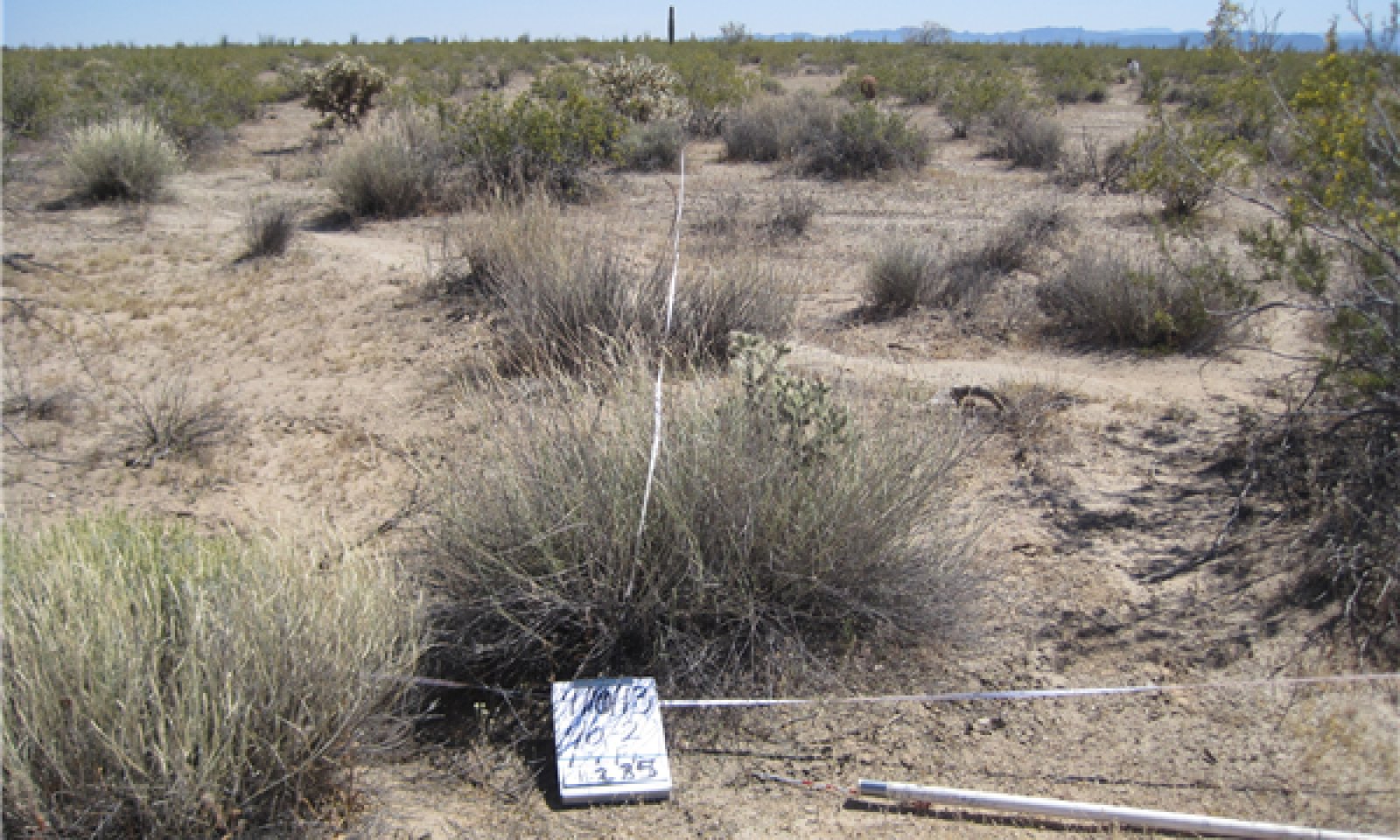
The potential plant community is a mixture of desert shrubs and sub-shrubs with cacti, perennial grasses and annuals well represented throughout. Creosote dominates with a wide range of other shrubs present, such as wolfberry, palo verde, graythorn, or ironwood, sparsely present. Sub-shrubs, an even mix of bursage and ratany, make up the sub-dominant, woody understory. Perennial grasses are somewhat constrained to waterflow paths and can be represented by a variety of species but most commonly bush muhly and big galleta are found. A variety of succulents, cholla species, prickly pears, cereus and barrel cacti are scattered on the site; saguaro may or may not be present. A wide variety of annual forbs and annual grasses are found nearly year-round after precipitation events due to the favorable growing conditions; annual production from annuals can exceed 100 #s/acre during a wet year. The aspect is open shrubland.
The soil surface generally lacks a protective gravel cover, but usually has extensive cryptogam cover. Crytogam cover ranges from 10 to 15% on the site. These lichens are communities made up of associations of blue green algae and fungi, which fix atmospheric nitrogen and form surface crusts that reduce erosion by both wind and water. With severe disturbance of these crusts, sheet and rill erosion can accelerate and dust blowing can be a problem. Plant populations for creosotebush ranges from 100 to 700 plants per acre. Some areas of this site receive rare flooding (once every 20 to 50 years). These events may cause severe mortality of creosotebush. Reestablishment is quick, however and the plant community soon is back to normal.Figure 8. Annual production by plant type (representative values) or group (midpoint values)
Table 5. Annual production by plant type
Plant type Low
(lb/acre)Representative value
(lb/acre)High
(lb/acre)Shrub/Vine 140 – 280 Forb 18 – 105 Grass/Grasslike 18 – 70 Total 176 – 455 State 2
Exotic AnnualsCommunity 2.1
Exotic Annual UnderstoryA few cool season, introduced annuals like; filaree, mediterranean grass and london rocket mustard can become entrenched in areas of this site and compete with native annual forbs and grasses. No mechanism to remove non-native annuals is known and once non-native annuals dominate this ecological site, disturbance drivers will follow the transitional paths as those from the reference state; therefore, States 3, 4, and 5 may have non-native annuals dominate the annual forbs and grass communities.
Wildlife habitat may be impaired because the non-native forbs do not provide adequate food and cover. Fire fuel loading after a flourish of either non-native or native annuals may carry fire.State 3
ShrubCommunity 3.1
Creosote Community
Figure 9. Limy Fan, 7-10" p.z., Creosote Community
Annual forbs and grasses (both native and exotic) will fluctuate with climate. This appears to be a stable community without fire or other disturbance like continuous grazing
State 4
BarrenCommunity 4.1
Annual Forb and Annual Grass CommunityOccasionally, after an unusually high production of annual forbs, a fire will burn. Natural fires are extremely rare, however, and if Limy Fan burns it is generally from human ignition.
State 5
ErodedCommunity 5.1
Eroded
Figure 10. Limy Fan, 7-10" p.z., Eroded
Transition T1A
State 1 to 2Transition T1B
State 1 to 3Transition T1C
State 1 to 4Transition T1D
State 1 to 5Restoration pathway R2A
State 2 to 1Conservation practices
Fence Firebreak Livestock Pipeline Pumping Plant Access Road Watering Facility Water Harvesting Catchment Water Well Upland Wildlife Habitat Management Livestock Shade Structure Livestock Use Area Protection Prescribed Grazing TA Planning TA Design TA Application TA Check-Out Fish and Wildlife Structure Fish and Wildlife Habitat Plan - Written Fish and Wildlife Habitat Plan - Applied Restoration pathway R3A
State 3 to 1Conservation practices
Critical Area Planting Fence Firebreak Livestock Pipeline Pumping Plant Rock Barrier Access Road Trails and Walkways Watering Facility Water Harvesting Catchment Water Well Upland Wildlife Habitat Management Early Successional Habitat Development/Management Controlled Livestock Lounging Area Livestock Shade Structure Snow Harvesting Record Keeping Well Plugging Livestock Use Area Protection Prescribed Grazing TA Planning TA Design TA Application TA Check-Out Dust Control on Unpaved Roads and Surfaces Road/Trail/Landing Closure and Treatment Fish and Wildlife Structure Fish and Wildlife Habitat Plan - Written Fish and Wildlife Habitat Plan - Applied Dust Control on Unpaved Roads and Surfaces Transition T3A
State 3 to 4Restoration pathway R4A
State 4 to 1Conservation practices
Critical Area Planting Fence Firebreak Access Control Livestock Pipeline Pumping Plant Rock Barrier Trails and Walkways Watering Facility Water Harvesting Catchment Water Well Upland Wildlife Habitat Management Early Successional Habitat Development/Management Controlled Livestock Lounging Area Livestock Shade Structure Snow Harvesting Record Keeping Well Plugging Livestock Use Area Protection Prescribed Grazing TA Planning TA Design TA Application TA Check-Out Dust Control on Unpaved Roads and Surfaces Road/Trail/Landing Closure and Treatment Fish and Wildlife Structure Fish and Wildlife Habitat Plan - Written Fish and Wildlife Habitat Plan - Applied Dust Control on Unpaved Roads and Surfaces Restoration pathway R4B
State 4 to 3Conservation practices
Critical Area Planting Water Well Decommissioning Fence Firebreak Access Control Livestock Pipeline Pumping Plant Rock Barrier Trails and Walkways Watering Facility Water Harvesting Catchment Water Well Upland Wildlife Habitat Management Early Successional Habitat Development/Management Controlled Livestock Lounging Area Livestock Shade Structure Snow Harvesting Well Plugging Livestock Use Area Protection Prescribed Grazing TA Planning TA Design TA Application TA Check-Out Well Water Testing Dust Control on Unpaved Roads and Surfaces Road/Trail/Landing Closure and Treatment Fish and Wildlife Structure Grazing Management Plan - Written Grazing Management Plan - Applied Fish and Wildlife Habitat Plan - Written Fish and Wildlife Habitat Plan - Applied Dust Control on Unpaved Roads and Surfaces Transition T4A
State 4 to 5Additional community tables
Table 6. Community 1.1 plant community composition
Group Common name Symbol Scientific name Annual production () Foliar cover (%) Grass/Grasslike1 Perennial Grasses 15–30 bush muhly MUPO2 Muhlenbergia porteri 2–5 – whiplash pappusgrass PAVA2 Pappophorum vaginatum 0–2 – big galleta PLRI3 Pleuraphis rigida 0–2 – plains bristlegrass SEVU2 Setaria vulpiseta 0–2 – sand dropseed SPCR Sporobolus cryptandrus 0–2 – slim tridens TRMU Tridens muticus 0–2 – purple threeawn ARPU9 Aristida purpurea 0–2 – blue threeawn ARPUN Aristida purpurea var. nealleyi 0–2 – Parish's threeawn ARPUP5 Aristida purpurea var. parishii 0–2 – Wright's threeawn ARPUW Aristida purpurea var. wrightii 0–2 – spidergrass ARTE3 Aristida ternipes 0–2 – spidergrass ARTEG Aristida ternipes var. gentilis 0–2 – low woollygrass DAPU7 Dasyochloa pulchella 0–2 – Arizona cottontop DICA8 Digitaria californica 0–2 – 2 Annual Grasses 3–50 sixweeks threeawn ARAD Aristida adscensionis 0–10 – prairie threeawn AROL Aristida oligantha 0–10 – needle grama BOAR Bouteloua aristidoides 0–10 – Arizona signalgrass URAR Urochloa arizonica 0–7 – sixweeks fescue VUOC Vulpia octoflora 0–7 – Pacific fescue VUMIP Vulpia microstachys var. pauciflora 0–5 – sixweeks grama BOBA2 Bouteloua barbata 0–5 – Rothrock's grama BORO2 Bouteloua rothrockii 0–5 – Arizona brome BRAR4 Bromus arizonicus 0–1 – feather fingergrass CHVI4 Chloris virgata 0–1 – canyon cupgrass ERLE7 Eriochloa lemmonii 0–1 – desert lovegrass ERPEM Eragrostis pectinacea var. miserrima 0–1 – tufted lovegrass ERPEP2 Eragrostis pectinacea var. pectinacea 0–1 – Mexican sprangletop LEFUU Leptochloa fusca ssp. uninervia 0–1 – mucronate sprangletop LEPA6 Leptochloa panicea 0–1 – delicate muhly MUFR Muhlenbergia fragilis 0–1 – littleseed muhly MUMI Muhlenbergia microsperma 0–1 – Bigelow's bluegrass POBI Poa bigelovii 0–1 – Eastwood fescue VUMIC Vulpia microstachys var. ciliata 0–1 – Forb3 Perennial Forbs 35–50 evening primrose OENOT Oenothera 0–5 – desert globemallow SPAM2 Sphaeralcea ambigua 0–5 – pricklyleaf dogweed THAC Thymophylla acerosa 0–1 – Tumamoc globeberry TUMA Tumamoca macdougalii 0–1 – dwarf desertpeony ACNA2 Acourtia nana 0–1 – weakleaf bur ragweed AMCO3 Ambrosia confertiflora 0–1 – southern Sierra pincushion CHAL Chaenactis alpigena 0–1 – whitemargin sandmat CHAL11 Chamaesyce albomarginata 0–1 – shrubby deervetch LORI3 Lotus rigidus 0–1 – 4 Annual Forbs 15–105 common fiddleneck AMMEI2 Amsinckia menziesii var. intermedia 0–10 – bristly fiddleneck AMTE3 Amsinckia tessellata 0–10 – desert Indianwheat PLOV Plantago ovata 0–10 – buckwheat ERIOG Eriogonum 0–10 – Coulter's globemallow SPCO2 Sphaeralcea coulteri 0–5 – western tansymustard DEPI Descurainia pinnata 0–5 – cryptantha CRYPT Cryptantha 0–3 – hairy prairie clover DAMO Dalea mollis 0–1 – American wild carrot DAPU3 Daucus pusillus 0–1 – carelessweed AMPA Amaranthus palmeri 0–1 – touristplant DIWI2 Dimorphocarpa wislizeni 0–1 – flatcrown buckwheat ERDE6 Eriogonum deflexum 0–1 – miniature woollystar ERDI2 Eriastrum diffusum 0–1 – erigenia ERIGE Erigenia 0–1 – fringed amaranth AMFI Amaranthus fimbriatus 0–1 – milkvetch ASTRA Astragalus 0–1 – wheelscale saltbush ATEL Atriplex elegans 0–1 – wheelscale saltbush ATELF Atriplex elegans var. fasciculata 0–1 – Wright's saltbush ATWR Atriplex wrightii 0–1 – Coulter's spiderling BOCO2 Boerhavia coulteri 0–1 – hoary bowlesia BOIN3 Bowlesia incana 0–1 – exserted Indian paintbrush CAEXE Castilleja exserta ssp. exserta 0–1 – yellow tackstem CAPA7 Calycoseris parryi 0–1 – white tackstem CAWR Calycoseris wrightii 0–1 – brittle spineflower CHBR Chorizanthe brevicornu 0–1 – aridland goosefoot CHDE Chenopodium desiccatum 0–1 – hyssopleaf sandmat CHHY3 Chamaesyce hyssopifolia 0–1 – devil's spineflower CHRI Chorizanthe rigida 0–1 – Esteve's pincushion CHST Chaenactis stevioides 0–1 – sand pygmyweed CRCO34 Crassula connata 0–1 – woollyhead neststraw STMI2 Stylocline micropoides 0–1 – sand fringepod THCU Thysanocarpus curvipes 0–1 – cutleaf thelypody THLA Thelypodium laciniatum 0–1 – woolly tidestromia TILA2 Tidestromia lanuginosa 0–1 – doubleclaw PRPA2 Proboscidea parviflora 0–1 – New Mexico plumeseed RANE Rafinesquia neomexicana 0–1 – chia SACO6 Salvia columbariae 0–1 – sleepy silene SIAN2 Silene antirrhina 0–1 – common woolly sunflower ERLA6 Eriophyllum lanatum 0–1 – Texas stork's bill ERTE13 Erodium texanum 0–1 – California poppy ESCAM Eschscholzia californica ssp. mexicana 0–1 – pygmy poppy ESMI Eschscholzia minutiflora 0–1 – hairy desertsunflower GECA2 Geraea canescens 0–1 – gilia GILIA Gilia 0–1 – Arizona poppy KAGR Kallstroemia grandiflora 0–1 – California goldfields LACA7 Lasthenia californica 0–1 – Gordon's bladderpod LEGO Lesquerella gordonii 0–1 – shaggyfruit pepperweed LELA Lepidium lasiocarpum 0–1 – Bigelow's linanthus LIBI2 Linanthus bigelovii 0–1 – coastal bird's-foot trefoil LOSA Lotus salsuginosus 0–1 – Arizona lupine LUAR4 Lupinus arizonicus 0–1 – Coulter's lupine LUSP2 Lupinus sparsiflorus 0–1 – disc mayweed MADI6 Matricaria discoidea 0–1 – blazingstar MENTZ Mentzelia 0–1 – Nuttall's povertyweed MONU Monolepis nuttalliana 0–1 – bristly nama NAHI Nama hispidum 0–1 – glandular threadplant NEGL Nemacladus glanduliferus 0–1 – lineleaf whitepuff OLLI Oligomeris linifolia 0–1 – Florida pellitory PAFL3 Parietaria floridana 0–1 – combseed PECTO Pectocarya 0–1 – manybristle chinchweed PEPA2 Pectis papposa 0–1 – phacelia PHACE Phacelia 0–1 – Shrub/Vine5 Dominant Shrubs 105–210 creosote bush LATR2 Larrea tridentata 105–210 – 6 Dominant Half-Shrubs 35–70 burrobush AMDU2 Ambrosia dumosa 10–25 – triangle bur ragweed AMDE4 Ambrosia deltoidea 10–20 – white ratany KRGR Krameria grayi 5–15 – littleleaf ratany KRER Krameria erecta 5–10 – 7 Miscellaneous Shrubs 3–7 whitethorn acacia ACCO2 Acacia constricta 0–1 – cattle saltbush ATPO Atriplex polycarpa 0–1 – crucifixion thorn CAEM4 Castela emoryi 0–1 – ocotillo FOSP2 Fouquieria splendens 0–1 – crown of thorns KOSP Koeberlinia spinosa 0–1 – water jacket LYAN Lycium andersonii 0–1 – Berlandier's wolfberry LYBE Lycium berlandieri 0–1 – Arizona desert-thorn LYEX Lycium exsertum 0–1 – desert ironwood OLTE Olneya tesota 0–1 – yellow paloverde PAMI5 Parkinsonia microphylla 0–1 – velvet mesquite PRVE Prosopis velutina 0–1 – whitestem paperflower PSCO2 Psilostrophe cooperi 0–1 – lotebush ZIOB Ziziphus obtusifolia 0–1 – 8 Succulents 3–10 candy barrelcactus FEWI Ferocactus wislizeni 0–1 – beavertail pricklypear OPBA2 Opuntia basilaris 0–1 – nightblooming cereus PEGR3 Peniocereus greggii 0–1 – Table 7. Community 2.1 plant community composition
Group Common name Symbol Scientific name Annual production () Foliar cover (%) Table 8. Community 3.1 plant community composition
Group Common name Symbol Scientific name Annual production () Foliar cover (%) Table 9. Community 4.1 plant community composition
Group Common name Symbol Scientific name Annual production () Foliar cover (%) Table 10. Community 5.1 plant community composition
Group Common name Symbol Scientific name Annual production () Foliar cover (%) Interpretations
Animal community
This site produces no herbaceous forage for year round use. Shrubby species on the site are not palatable. In wet winters the production of cool season annuals can be very high and provide for a high carrying capacity of stocker cattle in the March-May grazing season.
Water developments will help some species of wildlife on this site. Cover, forage and diversity are lacking for the large desert mammals. This site is home to a variety of small burrowing mammals, reptiles and their predators.Other information
T&E: Antilocapra Americana sonoriensis
(Sonoran pronghorn)
Tumamoca Macdougalii
(Tumamoc globe berry)
Leptonycteris curasoa yerbebuena
(Lesser long-nosed bat)Supporting information
Type locality
Location 1: Pima County, AZ Township/Range/Section T10S R5E S26 General legal description Sells FO - Sif Oidak Dist., Tat Momoli Valley Location 2: Pima County, AZ Township/Range/Section T14S R6W S20 General legal description Tucson FO - Organ Pipe National Monument Location 3: Maricopa County, AZ Township/Range/Section T1S R7E S14 General legal description Chandler FO - General Motors Proving Grounds Contributors
Dan Robinett
Dan Robinett, J. Norris
Larry D. Ellicott
Steve BarkerRangeland health reference sheet
Interpreting Indicators of Rangeland Health is a qualitative assessment protocol used to determine ecosystem condition based on benchmark characteristics described in the Reference Sheet. A suite of 17 (or more) indicators are typically considered in an assessment. The ecological site(s) representative of an assessment location must be known prior to applying the protocol and must be verified based on soils and climate. Current plant community cannot be used to identify the ecological site.
Author(s)/participant(s) Dave Womack, Byron Lambeth, Dan Robinett, Emilio Carrillo Contact for lead author NRCS Tucson Area Office Date 03/02/2005 Approved by Approval date Composition (Indicators 10 and 12) based on Annual Production Indicators
-
Number and extent of rills:
Rills are common and continuous in absence of high gravel cover. -
Presence of water flow patterns:
Water flow patterns are common, continuous and occupy 15-20% of area. -
Number and height of erosional pedestals or terracettes:
Accumulated pedestals on most perennial plants, not so much so in high gravel cover areas., 2-5 inches high. There are no pedestals on rock or gravel fragments and no terracettes are present. -
Bare ground from Ecological Site Description or other studies (rock, litter, lichen, moss, plant canopy are not bare ground):
10-60% (low values in high gravel cover areas and/or El Nino years. -
Number of gullies and erosion associated with gullies:
none -
Extent of wind scoured, blowouts and/or depositional areas:
none -
Amount of litter movement (describe size and distance expected to travel):
Woody litter mostly stays under plant canopy, herbaceous litter can travel long distances. -
Soil surface (top few mm) resistance to erosion (stability values are averages - most sites will show a range of values):
Soil surface resistance to erosion is good under shrub canopies to moderate in interspaces due to crusts formed by raindrop impact. -
Soil surface structure and SOM content (include type of structure and A-horizon color and thickness):
thin platy to weak granular; color is 7.5-10YR6/4 dry, 7.5-10YR4/4 moist, thickness to 3 inches. -
Effect of community phase composition (relative proportion of different functional groups) and spatial distribution on infiltration and runoff:
cover estimated as: Canopy 10-15%; 65% shrubs, 5% trees and 30% succulents. Cover is well dispersed throughout site. -
Presence and thickness of compaction layer (usually none; describe soil profile features which may be mistaken for compaction on this site):
None -
Functional/Structural Groups (list in order of descending dominance by above-ground annual-production or live foliar cover using symbols: >>, >, = to indicate much greater than, greater than, and equal to):
Dominant:
shrubs > subshrubs > trees > succulents > forbs = perennial grasses (Note: in El Nino years annual forbs and grasses are #1 in above ground weight)Sub-dominant:
Other:
Additional:
-
Amount of plant mortality and decadence (include which functional groups are expected to show mortality or decadence):
0-50% canopy mortality. Some areas have 70-80% canopy mortality. -
Average percent litter cover (%) and depth ( in):
-
Expected annual annual-production (this is TOTAL above-ground annual-production, not just forage annual-production):
200 lbs/ac unfavorable precipitation, 350 lbs/ac normal precipitation, 700 lbs/ac favorable precipitation -
Potential invasive (including noxious) species (native and non-native). List species which BOTH characterize degraded states and have the potential to become a dominant or co-dominant species on the ecological site if their future establishment and growth is not actively controlled by management interventions. Species that become dominant for only one to several years (e.g., short-term response to drought or wildfire) are not invasive plants. Note that unlike other indicators, we are describing what is NOT expected in the reference state for the ecological site:
Sahara mustard, schismus, filaree -
Perennial plant reproductive capability:
Not impaired for shrubs, drought impaired for perennial grasses and forbs.
Print Options
Sections
Font
AAAAOther
PrintThe Ecosystem Dynamics Interpretive Tool is an information system framework developed by the USDA-ARS Jornada Experimental Range, USDA Natural Resources Conservation Service, and New Mexico State University.
Accessibility statement


