
Natural Resources
Conservation Service
-
Search


Major Land Resource Area or ecological site by name and/or ID.
PreviousSectionsNextGeneral information
Provisional. A provisional ecological site description has undergone quality control and quality assurance review. It contains a working state and transition model and enough information to identify the ecological site.
Click to explore map
Figure 1. Mapped extent
Areas shown in blue indicate the maximum mapped extent of this ecological site. Other ecological sites likely occur within the highlighted areas. It is also possible for this ecological site to occur outside of highlighted areas if detailed soil survey has not been completed or recently updated.
MLRA notes
Major Land Resource Area (MLRA): 038X–Mogollon Transition South
AZ 38.3 – Upper Mogollon Transition
Elevations range from 5100-7000 feet and precipitation averages 20 to 27 inches per year. Vegetation includes Gambel oak, Arizona white oak, Emory oak, pinyon, alligator juniper, one seed juniper, Arizona cypress, ponderosa pine, shrubby buckwheat, sacahuista, skunkbush sumac, Wright silktassle, blue grama, sideoats grama, muttongrass, western wheatgrass, and bottlebrush squirreltail. The soil temperature regime is mesic and the soil moisture regime is typic ustic. This unit occurs within the Transition Zone Physiographic Province and is characterized by canyons and structural troughs or valleys. Igneous, metamorphic and sedimentary rock classes occur on rough mountainous terrain in association with less extensive sediment filled valleys exhibiting little integrated drainage.Associated sites
F038XC315AZ Ponderosa Pine - Gray Oak Forest 20-25" p.z. (PIPO, QUGR3)
At the upper elevations larger ponderosa pine occurs in the drainages of this site. Smaller stunted ponderosa pine intermingle with alligator juniper in upland positions.
R038XC302AZ Clayey Upland 20-24
The Clayey upland site occurs intermingled with this site. Clayey upland has a high percentage of western wheatgrass and vine mesquite in the plant community.
R038XC316AZ Clayey Slopes 20-24"
The Loamy slopes site occurs on skeletal soils and soils that are shallow to primarily quartzite bedrock. The loamy slopes site has a significant over story of gray and Emory oak, manzanita, beargrass and other Arizona chaparral species.
Similar sites
R038XC302AZ Clayey Upland 20-24
The clayey upland site can experience juniper encroachment similar to the clayloam upland site. Western wheatgrass is a significant grass of the clayey upland plant community. As the herbaceous component of the clayey upland site degrades annual goldeneye becomes a dominant annual on the site and can usually be a good key to differentiate the two sites in the absence of western wheatgrass.
Table 1. Dominant plant species
Tree Not specified
Shrub Not specified
Herbaceous Not specified
Physiographic features
This site occurs in the upper elevations of the Mogollon Transition zone south of the Mogollon Rim in central Arizona.
This site is primarily in an upland position but also occurs on hill slopes up to 15%. It neither benefits significantly from run-in moisture nor suffers from excess runoff.Table 2. Representative physiographic features
Landforms (1) Alluvial fan
(2) Plain
Elevation 5100 – 6400 ft Slope 2 – 15 % Ponding depth 0 in Aspect N, E, S Climatic features
Precipitation in this common resource area averages approximately 20 to 24 inches annually. Precipitation is lower and temperatures are cooler in the eastern part of the MLRA. The winter-summer rainfall ratio ranges from about 60/40% in the western part of the area to 45/55% in the eastern part. Summer rains fall July through September; and are from high-intensity convective thunderstorms. This moisture originates primarily from the Gulf of Mexico, but can come from the remnants of Pacific hurricanes in September. Winter moisture is frontal, originates in the north Pacific, and falls as rain or snow in widespread storms of low intensity and long duration. Snowfall ranges from 10 to 18 inches per year and can occur from November through April. May and June are the driest months of the year. Humidity is generally low all year.
Average annual air temperatures range from 50 to 57 degrees F (mesic temperature regime). Daytime temps in the summer are commonly in the mid 80's in the eastern portion of the MLRA and the low to mid 90's in the western portion. Freezing temperatures are common from October through April. The actual precipitation, available moisture and temperature varies, depending on, region, elevation, rain shadow effect and aspect.Table 3 Representative climatic features
Frost-free period (average) 170 days Freeze-free period (average) 190 days Precipitation total (average) 20 in BarLineFigure 2. Monthly precipitation range
BarLineFigure 3. Monthly average minimum and maximum temperature
">Influencing water features
There are no water features associated with this site.
Soil features
This site occurs near the highest elevations of the interior chaparral zone in the Mogollon Transition area. This site primarily occurs in an upland position. It occurs in small amount on low slope hills and ridge-tops.
These soils are deep, clayey throughout, and well drained. They are formed in alluvium from basalt, andesite, related volcanic tuffs and ash, and quartzite. The surface textures range from heavy loam, clayloam, to light clay. The effective rooting depth is 30 to 60 inches, plus. Runoff is slow on dry lightly vertic soils due to cracks and holes, but is moderate to high on moist soils. The erosion hazard is slight unless heavy traffic causes trailing and compaction.
Soil series mapped include: from SSA-675 San Carlos IR Area MU's Anezul-3 & 48, Dedal-3, Sponiker-35 & 78.Table 4. Representative soil features
Parent material (1) Alluvium – basalt
Surface texture (1) Gravelly clay loam
(2) Clay
Family particle size (1) Clayey
Drainage class Well drained Permeability class Moderately slow to slow Soil depth 60 in Surface fragment cover <=3" 0 – 35 % Surface fragment cover >3" 0 – 15 % Available water capacity
(0-40in)5.9 – 10.5 in Calcium carbonate equivalent
(0-40in)0 – 5 % Electrical conductivity
(0-40in)0 – 2 mmhos/cm Sodium adsorption ratio
(0-40in)0 – 2 Soil reaction (1:1 water)
(0-40in)6.6 – 8 Subsurface fragment volume <=3"
(Depth not specified)0 – 15 % Subsurface fragment volume >3"
(Depth not specified)0 – 15 % Ecological dynamics
The historic native plant community includes grasslands and Alligator juniper savannas. In areas with higher slopes southern exposures have a grassland aspect, northern exposures develop a mixed tree savanna. The plant community includes a flora of native annual grasses and forbs of both the winter and summer seasons. Periodic wildfires occurred at moderate intervals and helped maintain open grasslands and a balance between herbaceous plants and trees in savannas. In the absence of fire for longer periods trees can become dominant. The interactions of drought, fire and continuous livestock grazing can, over time, result in the loss of palatable perennial grasses.
State and transition model
Custom diagramStandard diagram
More interactive model formats are also available. View Interactive Models
More interactive model formats are also available. View Interactive Models
Click on state and transition labels to scroll to the respective textEcosystem states
States 1 and 6 (additional transitions)
State 2 submodel, plant communities
State 3 submodel, plant communities
State 4 submodel, plant communities
State 5 submodel, plant communities
State 6 submodel, plant communities
State 1
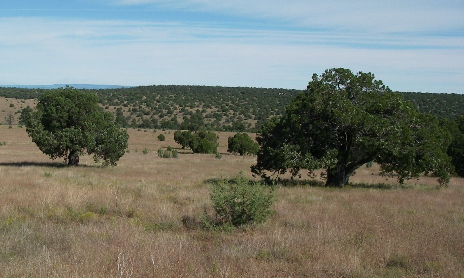
Reference StateSideoats grama is the dominant grass species and occurs as a grassland or savanna where alligator juniper is the tree species. Large diameter alligator juniper trees (24-48" Diameter at Root Collar) range from 1 to 5 per acre.
Community 1.1
Midgrass Alligator Juniper Savanna
Figure 4. 1.1 Midgrass alligator juniper savanna
The reference plant community is grassland or a savanna dominated by sideoats grama. Blue grama is a large component of the community in the eastern portion of the CRA and a mixture of hairy and blue grama are large components in the western portion of the CRA. Prairie junegrass, muttongrass and bottlebrush squirreltail are a trace group of cool season grasses in the plant community and can diminish to lower levels after severe winter - spring drought. Alligator juniper is the principal tree species. A flora of native annual forbs and grasses, of both the winter and summer seasons, exist in the plant community. Periodic, naturally occurring, wildfires were important in maintaining the reference plant community.
Figure 5. Annual production by plant type (representative values) or group (midpoint values)
Table 5. Annual production by plant type
Plant type Low
(lb/acre)Representative value
(lb/acre)High
(lb/acre)Grass/Grasslike 1100 1400 1789 Tree 0 30 60 Shrub/Vine 5 25 50 Forb 5 20 40 Total 1110 1475 1939 Table 6. Soil surface cover
Tree basal cover 0-0% Shrub/vine/liana basal cover 0-0% Grass/grasslike basal cover 20-20% Forb basal cover 0-0% Non-vascular plants 0% Biological crusts 0% Litter 50-90% Surface fragments >0.25" and <=3" 0-40% Surface fragments >3" 0-20% Bedrock 0% Water 0% Bare ground 0% Table 7. Canopy structure (% cover)
Height Above Ground (ft) Tree Shrub/Vine Grass/
GrasslikeForb <0.5 – – 5-10% 0-3% >0.5 <= 1 – 0-5% 20-30% 0-5% >1 <= 2 – – 40-50% 0-1% >2 <= 4.5 0-10% – 5-10% – >4.5 <= 13 – – – – >13 <= 40 0-5% – – – >40 <= 80 – – – – >80 <= 120 – – – – >120 – – – – Figure 6. Plant community growth curve (percent production by month). AZ3813 , 38.3 20-24"p.z. all sites. Growth begins in the spring and continues into the summer and fall..
Jan Feb Mar Apr May Jun Jul Aug Sep Oct Nov Dec J F M A M J J A S O N D 0 0 5 15 10 15 15 20 10 5 5 0 Community 1.2
Midgrass / alligator juniper savanna and sapling Community
Figure 7. 1.2 High juniper saplings
Alligator juniper savanna with 1 to 5 larger diameter (24-48" Diameter at Root Collar) trees per acre and 25-75 saplings per acre. Young juniper in this phase of the plant community have germinated and grown to approximately 3 feet tall. The fire management officer on Clifton Ranger District in the east portion of this Common Resource Area (CRA) reports prescribed fire is effective at killing saplings less than 2-3 feet tall. Fire is also effective at killing trees that have been cut and allowed to resprout before burning. Most trees that have resprouted are killed with a second fire if a first fire has not been effective. Fire has been most effective at killing both young trees and trees that have been cut and allowed to resprout when fire is applied in the fall or winter. The Clifton RD reports 70-80% kill of alligator juniper using these methods.
Community 1.3
Midgrass savanna / sub shrub communitySideoats grama is the dominant grass species. Populations of 200-300 snakeweed plants per acre are observed at substantial distances from livestock water. It has been observed that these populations can be a naturally occurring feature of the reference plant community and not a result of unmanaged livestock grazing. Snakeweed can naturally increase during climatic conditions favorable to its establishment and is easily killed by wildfire and drought, making this a periodic episode of the reference plant community. This increase in snakeweed has no observed negative affects to herbaceous production in terms of the plant community being able to support fires. Drought or naturally occurring wildfires reduce snakeweeds densities to 0-20 plants per acre.
Pathway 1.1A
Community 1.1 to 1.2
Midgrass Alligator Juniper Savanna
Midgrass / alligator juniper savanna and sapling CommunityFavorable weather for juniper seeds to establish and absence of fire allowing seedlings to grow to sapling size. Naturally occurring wildfire or prescribed fire before junipers become resistant to fire eliminates the saplings.
Pathway 1.2A
Community 1.1 to 1.3Favorable weather patterns favor establishment of snakeweed seed, plants survive and grow to mature plants. Naturally occurring wildfire, prescribed fire, or severe winter/spring drought severely reduces or eliminates snakeweed plants.
Pathway 1.1A
Community 1.2 to 1.1
Midgrass / alligator juniper savanna and sapling Community
Midgrass Alligator Juniper SavannaNatural or prescribed fire kills saplings less than 3 feet tall, restoring grassland or savanna aspect.
Conservation practices
Prescribed Burning Pathway 1.2A
Community 1.3 to 1.1Drought and/or natural or prescribed fires kill snakeweed plants which restores the grassland or savanna aspect
Conservation practices
Prescribed Burning State 2
Short grass StateSideoats grama is replaced by blue and or hairy grama.
Community 2.1
Blue grama grassland community
Figure 8. 2.1 Blue grama grassland
Continuous heavy herbivory from elk or livestock reduce the vigor of the dominant grass, sideoats grama. Blue grama being more tolerant of heavy herbivory replaces sidoeats grama as the dominant grass and with very heavy herbivory becomes a sod grass versus a bunchgrass.
State 3
Low cover juniper StateAlligator juniper tree canopies are 10 foot in diameter and approximately 20-25 feet apart.
Community 3.1
Low cover alligator juniper Community
Figure 9. 3.1 Low Juniper Cover
Alligator juniper has increased in canopy cover where trees averaging 10 foot canopy diameter are approximately 20-25 feet apart. Good herbaceous production occurs in the interspaces of the trees but practitioners are unlikely to apply fire in the hottest seasons with this level of tree canopy due to tree canopy fires and extreme fire behavior.
Tree shredding has been applied on a limited basis in similar communities in the east central portion of the MLRA. The herbaceous response 2-3 years after shredding was capable of carrying a broadcast fire. This was based on the Clifton Ranger District fire management officer’s suggestion that 800 lbs per acre of herbaceous fuel was the minimum requirement in their fire program.State 4
Intermediate cover juniper StateTree canopies are 15-20 feet in diameter and 10-15 feet apart.
Community 4.1
Intermediate cover alligator juniper woodland Community
Figure 10. 4.1 Intermediate Juniper Cover
Juniper tree canopies are 15-20 foot in diameter and 10-15 feet apart. Grass production with sideoats grama as the dominant can still occur in the interspaces of trees and is still vigorous, reproductive, and capable of producing seed.
In the east central portion of the MLRA lightning caused fires have burned similar communities with 100% canopy kill but no studies have been conducted for effectiveness of the total kill of juniper on these sites.State 5
Juniper Woodland StateJuniper dominates the site.
Community 5.1
High cover alligator juniper woodland Community
Figure 11. 5.1 High Juniper Cover
Nearly all understory herbaceous species are lost. Cool season grasses are found under the canopies of juniper trees. Soil rill erosion is still minimal.
State 6
Juniper woodland, eroded StateHigh juniper cover, actively eroding soils.
Community 6.1
High cover alligator juniper woodland Community with eroded soils
Figure 12. 6.1 High juniper cover, Eroding soils
High canopy cover of juniper. Herbaceous species are restricted to trace amounts of cool season species found under canopies of trees. Rill erosion is severe.
Transition T1A
State 1 to 2Continuous heavy herbivory reducing vigor of sideoats grama. Blue or hairy grama become dominant grasses.
Transition T1B
State 1 to 6Exact mechanism is unknown and this transition likely occurs as a result of reduced vigor and ground cover of desirable perennial grass plants and subsequent establishment of the introduced species.
Restoration pathway R2A
State 2 to 1Unknown. Species other than blue grama only establish where livestock pipelines have been ripped into the soil or other disturbances have reduced the competitive nature of blue grama in east central Arizona and west central New Mexico grasslands. Contour ripping and range seeding may assist in this restoration.
Conservation practices
Grazing Land Mechanical Treatment Range Planting Transition T2A
State 2 to 3Fire suppression, continuous herbivory reducing fire fine fuel loads, junipers establishing and maturing into 10-15 foot tall trees. Potentially induced by changes in precipitation patterns favoring germination and establishment of cool season species.
Restoration pathway R3A
State 3 to 2Proper grazing use of remaining fine fuels. Lightning caused wildfire, mechanical removal of juniper trees followed by lightning or prescribed fire. Juniper mortality due to drought, principally at lower elevations of the site.
Conservation practices
Brush Management Prescribed Burning Prescribed Grazing Transition T3A
State 3 to 4Continued fire suppression. Extreme herbivory of remnant fine fuels. Additional juniper trees establish and or existing trees increase in size.
Restoration pathway R4B
State 4 to 1Unknown. Lightning or other extreme summer fire kills majority of juniper. Seeding after fire if herbaceous species are absent and very clayey subsoils are not exposed. Mechanical removal of juniper, reseeding, and lightning or prescribed fire once herbaceous fine fuels have recovered to support fire. If root is not removed by mechanical means maintenance fires should be applied as described for Community Phase 1.2 as this species will resprout. Alternative would be stump application of herbicide after cutting trees to control resprouting and prescribed fire to burn tree skeletons.
Transition T4A
State 4 to 5Continued fire suppression. Extreme herbivory of fine fuels.
Restoration pathway R5B
State 5 to 3Unknown. Lightning or other extreme summer fire kills greater amounts of juniper. Seeding after fire if very clayey subsoils are not exposed. Most junipers will resprout. Mechanical removal of larger junipers, reseeding, and lightning or prescribed fire once herbaceous fine fuels have recovered to support fire. Stump application of herbicide after cutting trees is needed to control sprouting if maintenance fire is not planned.
Conservation practices
Brush Management Prescribed Burning Range Planting Prescribed Grazing Restoration pathway R5A
State 5 to 4Unknown. Low intensity fire kills lesser amounts of juniper. Seeding after fire if very clayey subsoils are not exposed. Most junipers will resprout. Mechanical removal of larger junipers, reseeding, and lightning or prescribed fire once herbaceous fine fuels have recovered to support fire. Stump application of herbicide after cutting trees is needed to control sprouting if maintenance fire is not planned.
Conservation practices
Brush Management Prescribed Burning Grazing Land Mechanical Treatment Range Planting Transition T5A
State 5 to 6Continued fire suppression. Rill erosion leading to very deep rills on the site.
Additional community tables
Table 8. Community 1.1 plant community composition
Group Common name Symbol Scientific name Annual production () Foliar cover (%) Grass/Grasslike1 Mid Grasses 700–1209 sideoats grama BOCU Bouteloua curtipendula 700–1200 – cane bluestem BOBA3 Bothriochloa barbinodis 0–5 – plains lovegrass ERIN Eragrostis intermedia 0–1 – green sprangletop LEDU Leptochloa dubia 0–1 – bullgrass MUEM Muhlenbergia emersleyi 0–1 – 2 Cool season grasses 5–40 squirreltail ELEL5 Elymus elymoides 3–20 – prairie Junegrass KOMA Koeleria macrantha 1–10 – muttongrass POFE Poa fendleriana 1–10 – 3 Misc. perennial grasses 0–10 Arizona threeawn ARAR6 Aristida arizonica 1–10 – Fendler threeawn ARPUL Aristida purpurea var. longiseta 0–5 – spidergrass ARTE3 Aristida ternipes 0–5 – Scribner's rosette grass DIOLS Dichanthelium oligosanthes var. scribnerianum 0–1 – hairy woollygrass ERPI5 Erioneuron pilosum 0–1 – spike muhly MUWR Muhlenbergia wrightii 0–1 – bulb panicgrass PABU Panicum bulbosum 0–1 – Pringle's speargrass PIPR2 Piptochaetium pringlei 0–1 – Texas bluestem SCCI2 Schizachyrium cirratum 0–1 – 4 Annual grasses 5–30 little barley HOPU Hordeum pusillum 0–30 – sixweeks threeawn ARAD Aristida adscensionis 0–10 – prairie threeawn AROL Aristida oligantha 0–10 – small fescue VUMI Vulpia microstachys 0–5 – sixweeks fescue VUOC Vulpia octoflora 0–5 – delicate muhly MUFR Muhlenbergia fragilis 0–2 – littleseed muhly MUMI Muhlenbergia microsperma 0–2 – 5 Short grasses 300–500 blue grama BOGR2 Bouteloua gracilis 200–350 – hairy grama BOHI2 Bouteloua hirsuta 10–300 – common wolfstail LYPH Lycurus phleoides 10–25 – curly-mesquite HIBE Hilaria belangeri 0–10 – Forb6 Perennial forbs 5–20 Cuman ragweed AMPS Ambrosia psilostachya 0–3 – white sagebrush ARLU Artemisia ludoviciana 0–1 – perennial rockcress ARPE2 Arabis perennans 0–1 – wholeleaf Indian paintbrush CAIN14 Castilleja integra 0–1 – sego lily CANU3 Calochortus nuttallii 0–1 – whitemargin sandmat CHAL11 Chamaesyce albomarginata 0–1 – rose heath CHER2 Chaetopappa ericoides 0–1 – whiteflower prairie clover DAAL Dalea albiflora 0–1 – Torrey's craglily ECFL Echeandia flavescens 0–1 – trailing fleabane ERFL Erigeron flagellaris 0–1 – silver dwarf morning-glory EVSE Evolvulus sericeus 0–1 – shortsepal lewisia LEBR Lewisia brachycalyx 0–1 – Lewis flax LILE3 Linum lewisii 0–1 – New Mexico yellow flax LINE Linum neomexicanum 0–1 – monkeyflower MIMUL Mimulus 0–1 – New Mexico groundsel PANE7 Packera neomexicana 0–1 – orange fameflower PHAU13 Phemeranthus aurantiacus 0–1 – Fendler's groundcherry PHHEF Physalis hederifolia var. fendleri 0–1 – slimflower scurfpea PSTE5 Psoralidium tenuiflorum 0–1 – Arizona spikemoss SEAR2 Selaginella arizonica 0–1 – Fendler's globemallow SPFE Sphaeralcea fendleri 0–1 – Rusby's globemallow SPRU2 Sphaeralcea rusbyi 0–1 – stemless Townsend daisy TOEX2 Townsendia exscapa 0–1 – toadflax penstemon PELI2 Penstemon linarioides 0 – Cooley's bundleflower DECO2 Desmanthus cooleyi 0 – 7 Annual forbs 5–20 woolly plantain PLPA2 Plantago patagonica 0–5 – Arizona popcornflower PLAR Plagiobothrys arizonicus 0–2 – Wright's bird's beak COWR2 Cordylanthus wrightii 0–2 – western tansymustard DEPI Descurainia pinnata 0–2 – slender goldenweed MAGR10 Machaeranthera gracilis 0–2 – mesa tansyaster MATA Machaeranthera tagetina 0–1 – slender phlox MIGRG4 Microsteris gracilis var. gracilis 0–1 – Lindley's silverpuffs MILI5 Microseris lindleyi 0–1 – wedgeleaf draba DRCU Draba cuneifolia 0–1 – harlequinbush GAHEG Gaura hexandra ssp. gracilis 0–1 – longleaf false goldeneye HELOA2 Heliomeris longifolia var. annua 0–1 – crestrib morning-glory IPCO2 Ipomoea costellata 0–1 – intermediate pepperweed LEVIM Lepidium virginicum var. medium 0–1 – New Mexico copperleaf ACNE Acalypha neomexicana 0–1 – annual agoseris AGHE2 Agoseris heterophylla 0–1 – western rockjasmine ANOC2 Androsace occidentalis 0–1 – smallflowered milkvetch ASNU4 Astragalus nuttallianus 0–1 – blunt tansymustard DEOB Descurainia obtusa 0–1 – redseed plantain PLRH Plantago rhodosperma 0–1 – Douglas' knotweed PODO4 Polygonum douglasii 0–1 – little hogweed POOL Portulaca oleracea 0–1 – sawtooth sage SASU7 Salvia subincisa 0–1 – sleepy silene SIAN2 Silene antirrhina 0–1 – stemless Townsend daisy TOEX2 Townsendia exscapa 0–1 – clasping Venus' looking-glass TRPE4 Triodanis perfoliata 0–1 – Tree8 Trees 0–60 alligator juniper JUDE2 Juniperus deppeana 0–60 – alligator juniper JUDE2 Juniperus deppeana 0 – Shrub/Vine9 Shrubs 0–5 hollyleaf redberry RHIL Rhamnus ilicifolia 0–2 – skunkbush sumac RHTR Rhus trilobata 0–2 – yerba de pasmo BAPT Baccharis pteronioides 0–1 – Wright's silktassel GAWR3 Garrya wrightii 0–1 – catclaw mimosa MIACB Mimosa aculeaticarpa var. biuncifera 0–1 – 10 Sub shrubs 0–50 bastardsage ERWR Eriogonum wrightii 0–50 – broom snakeweed GUSA2 Gutierrezia sarothrae 0–15 – 11 Cacti 0–2 Parry's agave AGPA4 Agave parryi 0–2 – walkingstick cactus CYSP8 Cylindropuntia spinosior 0–1 – pinkflower hedgehog cactus ECFE Echinocereus fendleri 0–1 – spinystar ESVIV Escobaria vivipara var. vivipara 0–1 – cactus apple OPEN3 Opuntia engelmannii 0–1 – twistspine pricklypear OPMA2 Opuntia macrorhiza 0–1 – tulip pricklypear OPPH Opuntia phaeacantha 0–1 – Table 9. Community 1.2 plant community composition
Group Common name Symbol Scientific name Annual production () Foliar cover (%) Table 10. Community 1.3 plant community composition
Group Common name Symbol Scientific name Annual production () Foliar cover (%) Table 11. Community 2.1 plant community composition
Group Common name Symbol Scientific name Annual production () Foliar cover (%) Table 12. Community 3.1 plant community composition
Group Common name Symbol Scientific name Annual production () Foliar cover (%) Table 13. Community 4.1 plant community composition
Group Common name Symbol Scientific name Annual production () Foliar cover (%) Table 14. Community 5.1 plant community composition
Group Common name Symbol Scientific name Annual production () Foliar cover (%) Table 15. Community 6.1 plant community composition
Group Common name Symbol Scientific name Annual production () Foliar cover (%) Interpretations
Animal community
This site is a significant habitat for pronghorn antelope. Elk utilize this site to a good degree in the evening coming out of shrub dominated browse sites at elevations below this site and ponderosa pine forests above this site.
This site is suitable for livestock grazing year round. There are limited areas of very cobbly surfaces that receive little livestock use. This site is susceptible to erosion in areas with very high livestock utilization like bed grounds, livestock trails, and areas adjacent to water.Hydrological functions
This site has high basal cover of perennial bunch grasses that maintain short water flow paths and relatively high infiltration. As this site is used by wildlife and livestock at higher degrees blue grama becomes the dominant species at most locations. If blue grama is maintained as a vigorous bunchgrass it provides a good level of infiltration on the site. As the vigor of blue grama further decreases at high levels of wildlife and livestock utilization and becomes a sod grass runoff can become significant but the grass can still provide a fair degree of soil protection and pedestalling is not very extensive. At severe levels of wildlife and livestock utilization where the basal cover of blue grama is reduced soil erosion can become significant and pedestalling of grass plants becomes significant. The interaction between juniper competition and severe wildlife and livestock utilization can reduce the cover of herbaceous plants to the point where severe rill formation begins to occur.
Recreational uses
Hunting, camping, horseback riding, backpacking, rock hounding, photography.
Wood products
In the reference community there is limited harvest of fuel wood, fence posts and stays from pinyon and juniper. Substantial quantities of juniper are available on this site where it has been allowed to progress to woodland. Volume of wood can be calculated from David Chojnacky's 1988 publication: Juniper, pinyon, oak and mesquite volume equations for Arizona.
Other products
Western Apache use approximately 700 species of plants in the region. This site provides an important source of plants and animals for traditional uses in the reference state. As the site degrades to woodland the number of species of plants and animals used for traditional purposes declines significantly.
Supporting information
Inventory data references
Production data were obtained by dry weight rank/comparative yield method for herbaceous and sub shrub species. Production data for trees and shrubs were obtained from ocular estimates on a per acre basis and the use of AZ NRCS Range Technical Note #52 due to the low densities of these species.
Type locality
Location 1: Gila County, AZ General legal description South of Salt River Canyon above Seneca Lake. Contributors
Dave Womack
Larry D. EllicottRangeland health reference sheet
Interpreting Indicators of Rangeland Health is a qualitative assessment protocol used to determine ecosystem condition based on benchmark characteristics described in the Reference Sheet. A suite of 17 (or more) indicators are typically considered in an assessment. The ecological site(s) representative of an assessment location must be known prior to applying the protocol and must be verified based on soils and climate. Current plant community cannot be used to identify the ecological site.
Author(s)/participant(s) Dave Womack, Emilio Carrillo, Scott Stratton, Dan Robinett Contact for lead author USDA NRCS Tucson Area Office Date 03/15/2011 Approved by Approval date Composition (Indicators 10 and 12) based on Annual Production Indicators
-
Number and extent of rills:
None present on the site. Perennial grass basal area is 15-20%, dominated by bunchgrasses less than 12" apart, promote infiltration, and break up water flow reducing its energy and ability to produce rills on the site. -
Presence of water flow patterns:
Water flow paths are less than 12 inches in length before encountering plant bases. Perennial grass basal area is 15-20%, dominated by bunchgrasses less than 12" apart and breaks up water flow paths. -
Number and height of erosional pedestals or terracettes:
None present on the site. Very high density of plants reduces potential for soil erosion and pedestal formation. Plant community is dominated by bunchgrasses that are not conducive to terracette formation. -
Bare ground from Ecological Site Description or other studies (rock, litter, lichen, moss, plant canopy are not bare ground):
2-10%. -
Number of gullies and erosion associated with gullies:
None present on the site. See #2 above. -
Extent of wind scoured, blowouts and/or depositional areas:
None present on the site. High density and canopy of perennial grass not conducive to wind erosion. -
Amount of litter movement (describe size and distance expected to travel):
Herbaceous litter travels less than 12 inches in water flow paths before being trapped by plant bases. -
Soil surface (top few mm) resistance to erosion (stability values are averages - most sites will show a range of values):
Soil stability values range from 4-6. -
Soil surface structure and SOM content (include type of structure and A-horizon color and thickness):
Soil surface structure is granular with weak to moderate rupture resistance. Surfaces range from 3 to 4 inches thick and have colors ranging from 7.5YR 4/3 to 10YR dry and 7.5YR 3/3 to 10YR 2/2 moist. -
Effect of community phase composition (relative proportion of different functional groups) and spatial distribution on infiltration and runoff:
Midgrasses >> short grasses > cool season grasses = annual forbs & grasses = trees & shrubs > perennial forbs. High density and 15-20% basal area of perennial grasses is very conducive to slowing down water leaving the site. -
Presence and thickness of compaction layer (usually none; describe soil profile features which may be mistaken for compaction on this site):
None present on the site. Argillic horizon is 2-4 inches deep and when dry has moderate to strong structure that can be mistaken for a compaction layer. -
Functional/Structural Groups (list in order of descending dominance by above-ground annual-production or live foliar cover using symbols: >>, >, = to indicate much greater than, greater than, and equal to):
Dominant:
Midgrasses >> short grassesSub-dominant:
cool season grass = annual forbs & grasses = trees & shrubsOther:
Additional:
-
Amount of plant mortality and decadence (include which functional groups are expected to show mortality or decadence):
Very low plant mortality; approximately 1-2% of short grasses are dead. -
Average percent litter cover (%) and depth ( in):
-
Expected annual annual-production (this is TOTAL above-ground annual-production, not just forage annual-production):
1100 lbs/ac below average year, 1500 lbs/ac average year, 1950 lbs/ac above average year -
Potential invasive (including noxious) species (native and non-native). List species which BOTH characterize degraded states and have the potential to become a dominant or co-dominant species on the ecological site if their future establishment and growth is not actively controlled by management interventions. Species that become dominant for only one to several years (e.g., short-term response to drought or wildfire) are not invasive plants. Note that unlike other indicators, we are describing what is NOT expected in the reference state for the ecological site:
Alligator juniper, yellow bluestem, yellow star thistle. -
Perennial plant reproductive capability:
Not affected after several years of drought in the region
Print Options
Sections
Font
AAAAOther
PrintThe Ecosystem Dynamics Interpretive Tool is an information system framework developed by the USDA-ARS Jornada Experimental Range, USDA Natural Resources Conservation Service, and New Mexico State University.
Accessibility statement


