
Natural Resources
Conservation Service
-
Search


Major Land Resource Area or ecological site by name and/or ID.
PreviousSectionsNextGeneral information
Provisional. A provisional ecological site description has undergone quality control and quality assurance review. It contains a working state and transition model and enough information to identify the ecological site.
Click to explore map
Figure 1. Mapped extent
Areas shown in blue indicate the maximum mapped extent of this ecological site. Other ecological sites likely occur within the highlighted areas. It is also possible for this ecological site to occur outside of highlighted areas if detailed soil survey has not been completed or recently updated.
MLRA notes
Major Land Resource Area (MLRA): 038X–Mogollon Transition South
AZ 38-2 - Middle Mogollon Transition
Elevations in this Land Resource Unit (LRU) range from 4500 to 6000 feet and precipitation averages 16 to 20 inches per year. Vegetation includes turbinella oak, Wright silktassel, hollyleaf buckthorn, desert buckbrush, one-seed juniper, alligator juniper, pinyon, algerita, sugar sumac, prairie junegrass, blue grama, curly mesquite, bottlebrush squirreltail, muttongrass, cane beardgrass, plains lovegrass and bullgrass. The soil temperature regime ranges from thermic to mesic and the soil moisture regime is aridic ustic. This unit occurs within the Transition Zone Physiographic Province and is characterized by canyons and structural troughs or valleys. Igneous, metamorphic and sedimentary rock classes occur on rough mountainous terrain in association with less extensive sediment filled valleys exhibiting little integrated drainage.Associated sites
R038XB204AZ Granitic Hills 16-20" p.z.
R038XB215AZ Clayey Hills 16-20" p.z.
Similar sites
R039XA105AZ Shallow Loamy 17-22" p.z.
Table 1. Dominant plant species
Tree (1) Juniperus coahuilensis
(2) Pinus edulisShrub (1) Quercus turbinella
(2) Dasylirion wheeleriHerbaceous (1) Bouteloua curtipendula
(2) Aristida purpurea var. nealleyiPhysiographic features
This site occurs in the middle to upper elevations of the Mogollon Transition zone, south of the Mogollon Rim in central Arizona. It occurs on rugged mountain slopes, ridge-tops and mesa sides. Wilcoxson soils are on gently, strongly sloping, and undulating uplands at elevations of 6,000 to 7,000 feet. Popcorn soils are on hills and mountains. Slope ranges from 15 to 75 percent.
Table 2. Representative physiographic features
Landforms (1) Hill
(2) Mountain slope
(3) Ridge
Elevation 4400 – 7000 ft Slope 15 – 75 % Aspect N, S, W Climatic features
Precipitation in this common resource area averages 16 to 20 inches annually. The winter-summer rainfall ratio ranges from about 60/40% in the western part of the area to 45/55% in the eastern part. Summer rains fall July through September; and are from high-intensity, convective, thunderstorms. This moisture originates primarily from the Gulf of Mexico, but can come from the remnants of Pacific hurricanes in September. Winter moisture is frontal, originates in the north Pacific, and falls as rain or snow in widespread storms of low intensity and long duration. Snowfall ranges from 5 to 35 inches per year and can occur from November through April. Snow seldom persists for more than a week. May and June are the driest months of the year. Humidity is moderate to low all year. Average annual air temperatures range from 51 to 60 degrees F (thermic temperature regime). Daytime temperatures in the summer are commonly in the low 90’s. Freezing temperatures are common from October through April. The actual precipitation, available moisture and temperature vary, depending on, region, elevation, rain shadow effect and aspect.
Table 3 Representative climatic features
Frost-free period (average) 180 days Freeze-free period (average) 240 days Precipitation total (average) 20 in BarLineFigure 2. Monthly precipitation range
BarLineFigure 3. Monthly average minimum and maximum temperature
">Influencing water features
Soil features
Wilcoxson soils formed in fine textured material weathered from limestone and calcareous sandstone or shale.
Popcorn series consists of shallow and very shallow, well drained, moderately permeable soils that formed in residuum and slope alluvium derived from limestone.
Yarbam series consists of very shallow and shallow, well drained soils that formed in slope alluvium, colluvium and residuum from calcareous sedimentary rock that includes limestone, marble, and calcareous sandstone.
Soils mapped under this site include: SSA637 Western Yavapai County MU WlF Wilcoxson and SSA675 San Carlos IR Area MU's 58 Popcorn & 77 Yarbam and Silverstrike family.Table 4. Representative soil features
Parent material (1) Residuum – limestone, sandstone, and shale
(2) Slope alluvium – limestone
(3) Colluvium – limestone and sandstone
Surface texture (1) Gravelly loam
(2) Extremely gravelly clay loam
Family particle size (1) Clayey
Drainage class Moderately well drained to well drained Permeability class Moderate to slow Soil depth 8 – 28 in Surface fragment cover <=3" 0 – 35 % Surface fragment cover >3" 0 – 5 % Available water capacity
(0-40in)0.7 – 3.2 in Calcium carbonate equivalent
(0-40in)5 – 80 % Electrical conductivity
(0-40in)0 – 2 mmhos/cm Sodium adsorption ratio
(0-40in)0 – 2 Soil reaction (1:1 water)
(0-40in)7.4 – 9 Subsurface fragment volume <=3"
(Depth not specified)0 – 45 % Subsurface fragment volume >3"
(Depth not specified)0 – 5 % Ecological dynamics
The plant communities found on an ecological site are naturally variable. Composition and production will vary with yearly conditions, location, aspect, and the natural variability of the soils. The Reference Plant Community represents the natural potential plant community found on relict or relatively undisturbed sites. Other plant communities described here represent plant communities that are known to occur when the site is disturbed by factors such as grazing, fire, absence of fire or drought.
Production data provided in this site description is standardized to air-dry weight at the end of the summer growing season. The plant communities described in this site description are based on near normal rainfall years.
NRCS uses a Similarity Index to compare existing plant communities to the plant communities described here. Similarity Index is determined by comparing the production and composition of a plant community to the production and composition of a plant community described in this site description. To determine Similarity Index, compare the production (air-dry weight) of each species to that shown in the plant community description. For each species, count no more than the maximum amount shown for the species, and for each group, count no more than the maximum shown for the group. Divide the resulting total by the total normal year production shown in the plant community description. If rainfall has been significantly above or below normal, use the total production shown for above or below normal years. If field data is not collected at the end of the summer growing season, then the field data must be corrected to the end of the year production before comparing it to the site description. The growth curve can be used as a guide for estimating production at the end of the summer growing season.State and transition model
Custom diagramStandard diagram
More interactive model formats are also available. View Interactive Models
More interactive model formats are also available. View Interactive Models
Click on state and transition labels to scroll to the respective textEcosystem states
State 1 submodel, plant communities
State 2 submodel, plant communities
State 3 submodel, plant communities
State 4 submodel, plant communities
State 1
Shrub/Grass StateThe Shrub/Grass State is the Reference Plant Community. Shrub canopy is 35-45% on all aspects.
Community 1.1
Reference Plant Community
Figure 4. 1.1 Reference Plant Community

Figure 5. Limestone Hills RPC #2
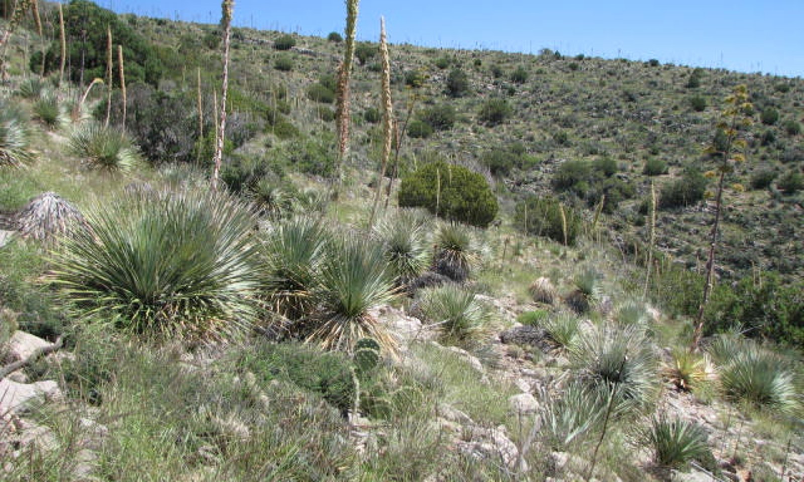
The Shrub/Grass State is the Reference Plant Community. It is a diverse mixture of perennial grasses, suffrutescent forbs, shrubs, succulents and scattered trees. A flora of native annual forbs and grasses, of both the winter and summer seasons, exist in the plant community. Periodic, naturally occurring, wildfires were important in maintaining the Reference Plant Community.
North slopes have a mixture of grass and evergreen chaparral shrubs like turbinella oak, mountain mahogany, and redberry buckthorn. Southern exposures will have a higher percentage of desert shrubs and succulents in the plant community. Shrub canopy is 35-45% on all aspects.Figure 6. Annual production by plant type (representative values) or group (midpoint values)
Table 5. Annual production by plant type
Plant type Low
(lb/acre)Representative value
(lb/acre)High
(lb/acre)Grass/Grasslike 200 400 600 Shrub/Vine 300 430 470 Tree 40 60 100 Forb 30 70 90 Total 570 960 1260 Table 6. Ground cover
Tree foliar cover 0-0% Shrub/vine/liana foliar cover 0-0% Grass/grasslike foliar cover 0-10% Forb foliar cover 0-0% Non-vascular plants 0% Biological crusts 0-0% Litter 30-50% Surface fragments >0.25" and <=3" 20-30% Surface fragments >3" 20-30% Bedrock 0% Water 0% Bare ground 0-10% Figure 7. Plant community growth curve (percent production by month). AZ3812 , 38.2 16-20" p.z. all sites. Growth begins in the spring and continues into the summer and fall..
Jan Feb Mar Apr May Jun Jul Aug Sep Oct Nov Dec J F M A M J J A S O N D 0 5 5 15 10 10 15 20 10 5 5 0 Community 1.2
Medium Canopy Shrub Community
Figure 8. 1.2 Medium Canopy Shrub Community
Shrubs increase in canopy and density to approximately 45-60% canopy in the absence of fire. Herbaceous species are present in sufficient quantity and are evenly distributed to promote fire intensities sufficient to reduce abundance of shrub species.
Community 1.3
Mixed Life Form Community
Figure 9. 1.3 Mixed Life Form Community
Juniper or pinyon germinate and are present at densities of 5-10 per acre and are still small in size. One seed or redberry juniper are the juniper species. Tree canopy is approximately 5-10%. Herbaceous production is approximately 700 lbs/ac and fires are effective at killing fire sensitive juniper and pinyon.
State 2
Non-Sprouting Shrub StateNon sprouting shrubs have increased to 60-80% canopy.
Community 2.1
Non-sprouting Shrub Community
Figure 10. 2.1 Non-sprouting Shrub Community
Non sprouting shrubs have increased to 60-80% canopy. Cooler aspects are dominated by sotol and minor amounts of turbinella oak. Warmer aspects are dominated by prickly pear, ocotillo, agave, cat claw acacia, and minor amounts of wait a bit. Herbaceous species are less than 100 lbs/ac and are not well distributed on the site.
State 3
Sprouting Shrub StateSprouting shrubs have increased to 60-80% canopy.
Community 3.1
Chaparral Community
Figure 11. 3.1 Chaparral Community
Turbinella oak has increased to 60-80% canopy in the absence of fire for extended periods of time. Herbaceous species are less than 100 lbs/ac and are not well distributed on the site.
A restoration pathway is unlikely from this state given the ability of turbinella oak to withstand substantial fire intensities (Pase 1965) and this species prolific root sprouting ability.
State 4
Juniper-pinyon StateJuniper and/or pinyon have increased to 40-50% canopy in the absence of fire for very long periods of time.
Community 4.1
Juniper-pinyon Community
Figure 12. 4.1 Juniper-pinyon Community

Figure 13. 4.1 Pinyon Community
Juniper and/or pinyon have increased to 40-50% canopy in the absence of fire for very long periods of time. The dominant juniper is one seed or redberry juniper. Herbaceous species are vigorous and evenly distributed in the interspaces of trees in areas where turbinella oak has not increased in the interspaces. These herbaceous species contribute to recovery of the site without the need for substantial inputs in the form of range planting.
Turbinella oak has increased to 20-30% canopy in some areas where pinyon has increased to 40-50% canopy. Herbaceous species are less than 100 lbs/ac and not well distributed on the site. It is unknown if this community can return to the reference plant community. This would only be likely with range planting applied after wildfire.Transition T1a
State 1 to 2Non sprouting shrubs like sotol and prickly pear germinate and in the absence of fire for prolonged periods grow to maturity and eventually dominate the site.
Transition T1b
State 1 to 3Sprouting shrubs, primarily turbinella oak that is the dominant shrub on other sites in this Land Resource Unit (16-20" precipitation zone), germinate and in the absence of fire for prolonged periods grow to maturity and eventually dominate the site.
Transition T1c
State 1 to 4Trees germinate and in the absence of fire for prolonged periods grow to maturity. High densities of perennial grasses can still occupy the interspaces of trees with tree canopy as high as 45-55%. Trees are of sufficient size that most practitioners are unlikely to apply prescribed fire.
Restoration pathway R2a
State 2 to 1It is unknown if this restoration is possible. Chemical brush management is likely the only alternative to reduce shrub species given the rocky nature of these soils. Range planting would be necessary to restore the herbaceous community if brush management is effective. Range planting would have greater success in this Land Resource Unit due to the higher rainfall this site receives.
Restoration pathway R4a
State 4 to 1Extreme wildfire is likely the only restoration pathway. Trees have reached such a large size that very high temperatures and wind speeds are needed to allow fires to burn through canopies and top kill non sprouting juniper or pinyon. Very costly mechanical brush management where soils have lower amount of cobbles or boulders and gentler slopes is possible followed by burning of tree skeletons. Perennial grass canopy in the interspaces of trees is > 50% in some areas with existing plants likely providing an adequate seed source for restoration following brush management or fires. Range planting should likely only be considered where perennial grass canopy in the interspaces of trees is less than 25%; however this threshold needs additional investigation.
Additional community tables
Table 7. Community 1.1 plant community composition
Group Common name Symbol Scientific name Annual production () Foliar cover (%) Grass/Grasslike1 Dominant Warm Season Grasses 80–435 sideoats grama BOCU Bouteloua curtipendula 50–200 – blue threeawn ARPUN Aristida purpurea var. nealleyi 5–100 – hairy grama BOHI2 Bouteloua hirsuta 15–85 – black grama BOER4 Bouteloua eriopoda 10–50 – 2 Cool Season Grasses 0–45 desert needlegrass ACSP12 Achnatherum speciosum 0–10 – squirreltail ELEL5 Elymus elymoides 0–10 – New Mexico feathergrass HENE5 Hesperostipa neomexicana 0–10 – prairie Junegrass KOMA Koeleria macrantha 0–10 – needle and thread HECO26 Hesperostipa comata 0–5 – 3 Miscellaneous grasses 5–150 bullgrass MUEM Muhlenbergia emersleyi 0–35 – Arizona threeawn ARAR6 Aristida arizonica 0–15 – curly-mesquite HIBE Hilaria belangeri 5–15 – green sprangletop LEDU Leptochloa dubia 1–10 – tanglehead HECO10 Heteropogon contortus 0–10 – cane bluestem BOBA3 Bothriochloa barbinodis 1–10 – longtongue muhly MULO Muhlenbergia longiligula 0–10 – slim tridens TRMU Tridens muticus 0–10 – slim tridens TRMUE Tridens muticus var. elongatus 0–10 – plains lovegrass ERIN Eragrostis intermedia 0–5 – hairy woollygrass ERPI5 Erioneuron pilosum 0–5 – Fendler threeawn ARPUL Aristida purpurea var. longiseta 0–5 – sand dropseed SPCR Sporobolus cryptandrus 0–5 – Arizona brome BRAR4 Bromus arizonicus 0–1 – common wolfstail LYPH Lycurus phleoides 0–1 – ring muhly MUTO2 Muhlenbergia torreyi 0–1 – Hall's panicgrass PAHA Panicum hallii 0–1 – 4 Annual grasses 0–35 sixweeks threeawn ARAD Aristida adscensionis 0–10 – sixweeks fescue VUOC Vulpia octoflora 0–10 – mucronate sprangeltop LEPAB Leptochloa panicea ssp. brachiata 0–5 – witchgrass PACA6 Panicum capillare 0–5 – Mexican panicgrass PAHI5 Panicum hirticaule 0–5 – little barley HOPU Hordeum pusillum 0–2 – delicate muhly MUFR Muhlenbergia fragilis 0–1 – Forb5 Perennial Forbs 10–125 variableleaf bushbean MAGI2 Macroptilium gibbosifolium 0–40 – desert globemallow SPAM2 Sphaeralcea ambigua 5–20 – brownfoot ACWR5 Acourtia wrightii 0–15 – white sagebrush ARLU Artemisia ludoviciana 0–10 – perennial rockcress ARPE2 Arabis perennans 1–10 – cliffbrake PELLA Pellaea 1–10 – trailing windmills ALIN Allionia incarnata 1–5 – wishbone-bush MILAV Mirabilis laevis var. villosa 0–2 – Colorado four o'clock MIMU Mirabilis multiflora 0–1 – brownplume wirelettuce STPA4 Stephanomeria pauciflora 0–1 – jewels of Opar TAPA2 Talinum paniculatum 0–1 – aster ASTER Aster 0–1 – mariposa lily CALOC Calochortus 0–1 – Indian paintbrush CASTI2 Castilleja 0–1 – bastard toadflax COUM Comandra umbellata 0–1 – bluedicks DICA14 Dichelostemma capitatum 0–1 – fleabane ERIGE2 Erigeron 0–1 – desert trumpet ERIN4 Eriogonum inflatum 0–1 – wild dwarf morning-glory EVAR Evolvulus arizonicus 0–1 – silver dwarf morning-glory EVSE Evolvulus sericeus 0–1 – southwestern mock vervain GLGO Glandularia gooddingii 0–1 – tufted globe amaranth GOCA Gomphrena caespitosa 0–1 – Gordon's bladderpod LEGO Lesquerella gordonii 0–1 – Chihuahuan flax LIVE2 Linum vernale 0–1 – dwarf Indian mallow ABPA3 Abutilon parvulum 0–1 – 6 Annual Forbs 0–50 spurge EUPHO Euphorbia 1–15 – longleaf false goldeneye HELOA2 Heliomeris longifolia var. annua 0–10 – bristly fiddleneck AMTE3 Amsinckia tessellata 0–10 – phacelia PHACE Phacelia 0–10 – desert Indianwheat PLOV Plantago ovata 0–5 – woolly plantain PLPA2 Plantago patagonica 0–5 – purslane PORTU Portulaca 0–1 – pitseed goosefoot CHBE4 Chenopodium berlandieri 0–1 – cryptantha CRYPT Cryptantha 0–1 – dodder CUSCU Cuscuta 0–1 – American wild carrot DAPU3 Daucus pusillus 0–1 – flatcrown buckwheat ERDE6 Eriogonum deflexum 0–1 – Thurber's pepperweed LETH2 Lepidium thurberi 0–1 – Arizona lupine LUAR4 Lupinus arizonicus 0–1 – New Mexico copperleaf ACNE Acalypha neomexicana 0–1 – Shrub/Vine7 Evergreen shrubs 10–145 Sonoran scrub oak QUTU2 Quercus turbinella 10–95 – alderleaf mountain mahogany CEMO2 Cercocarpus montanus 0–15 – Palmer oak QUPA10 Quercus palmeri 0–10 – redberry buckthorn RHCR Rhamnus crocea 0–8 – Mexican cliffrose PUME Purshia mexicana 0–5 – desert ceanothus CEGR Ceanothus greggii 0–5 – California buckthorn FRCAU Frangula californica ssp. ursina 0–2 – ashy silktassel GAFL2 Garrya flavescens 0–2 – Wright's silktassel GAWR3 Garrya wrightii 0–2 – red barberry MAHA4 Mahonia haematocarpa 0–1 – Apache plume FAPA Fallugia paradoxa 0–1 – 8 Large shrubs 5–50 catclaw mimosa MIACB Mimosa aculeaticarpa var. biuncifera 5–25 – mariola PAIN2 Parthenium incanum 0–10 – skunkbush sumac RHTR Rhus trilobata 0–6 – Wright's beebrush ALWR Aloysia wrightii 0–5 – stretchberry FOPUP Forestiera pubescens var. pubescens 0–2 – rockspirea HODU Holodiscus dumosus 0–1 – pale desert-thorn LYPA Lycium pallidum 0–1 – Coulter's brickellbush BRCO Brickellia coulteri 0–1 – Torrey's jointfir EPTO Ephedra torreyana 0–1 – 9 Half shrubs 55–190 fairyduster CAER Calliandra eriophylla 25–100 – featherplume DAFO Dalea formosa 30–40 – littleleaf ratany KRER Krameria erecta 0–25 – bastardsage ERWR Eriogonum wrightii 1–20 – rough menodora MESC Menodora scabra 0–5 – yerba de pasmo BAPT Baccharis pteronioides 0–2 – winterfat KRLA2 Krascheninnikovia lanata 0–1 – 10 Succulents 80–380 common sotol DAWH2 Dasylirion wheeleri 50–120 – sacahuista NOMI Nolina microcarpa 0–120 – Schott's century plant AGSC3 Agave schottii 10–60 – banana yucca YUBA Yucca baccata 20–50 – cactus apple OPEN3 Opuntia engelmannii 1–10 – ocotillo FOSP2 Fouquieria splendens 0–10 – tulip pricklypear OPPH Opuntia phaeacantha 0–5 – goldenflower century plant AGCH2 Agave chrysantha 0–1 – Parry's agave AGPA4 Agave parryi 0–1 – Arizona hedgehog cactus ECCOA Echinocereus coccineus var. arizonicus 0–1 – Engelmann's hedgehog cactus ECEN Echinocereus engelmannii 0–1 – candy barrelcactus FEWI Ferocactus wislizeni 0–1 – crucifixion thorn CAHO3 Canotia holacantha 0–1 – Christmas cactus CYLE8 Cylindropuntia leptocaulis 0–1 – walkingstick cactus CYSP8 Cylindropuntia spinosior 0–1 – Whipple cholla CYWH Cylindropuntia whipplei 0–1 – 11 Increaser half-shrubs 5–20 broom snakeweed GUSA2 Gutierrezia sarothrae 5–20 – turpentine bush ERLA12 Ericameria laricifolia 0–1 – Tree12 Trees 10–120 redberry juniper JUCO11 Juniperus coahuilensis 10–50 – oneseed juniper JUMO Juniperus monosperma 10–50 – singleleaf pinyon PIMO Pinus monophylla 0–50 – twoneedle pinyon PIED Pinus edulis 0–25 – alligator juniper JUDE2 Juniperus deppeana 0–20 – Table 8. Community 1.2 plant community composition
Group Common name Symbol Scientific name Annual production () Foliar cover (%) Table 9. Community 1.3 plant community composition
Group Common name Symbol Scientific name Annual production () Foliar cover (%) Table 10. Community 2.1 plant community composition
Group Common name Symbol Scientific name Annual production () Foliar cover (%) Table 11. Community 3.1 plant community composition
Group Common name Symbol Scientific name Annual production () Foliar cover (%) Table 12. Community 4.1 plant community composition
Group Common name Symbol Scientific name Annual production () Foliar cover (%) Interpretations
Animal community
Steep slopes, rock outcrop and surface cobbles may limit the utilization in areas of this site. Springs occur naturally on the site and their development and fenceing may be important to get effective management of the area. Also, livestock trails may be needed to aid distribution.
This site is excellent habitat for larger mammals. Natural water is present and the juxtaposition of grassy areas and brushy rockoutcrop areas make very good habitat. This site is especially important for whitetail and mule deer.Hydrological functions
This site has rough surfaces due to a high cover of gravels, cobbles, and stones which act to hold water on the site. The bedrock is very porous. When the soils are dry it produces little runoff. It produces significant runoff only when heavy rain falls on snow or moist soil.
Recreational uses
Landforms of the site are both rolling hills and rough steep mountains. Landscape view of this site is dominated by woody species with grassland openings and occasional rock outcrops. Summers are quite warm and winters are cold.
Activities well suited to this site are wildlife observation, hunting, hiking, photography and horseback riding.Wood products
The site is too remote and steep to make much use of wood products.
Other products
The harvesting of pinyon nuts is among the other uses of this site.
Supporting information
Type locality
Location 1: Gila County, AZ UTM zone N UTM northing 3667800 UTM easting 530200 General legal description Top of Mescal Mountains, Gila County Location 2: Yavapai County, AZ Township/Range/Section T16N R1E S1 General legal description Two miles north Highway 98 just inside U.S.F.S. fence. Yavapai County Other references
Pase, Charles P. 1965. Shrub seedling regeneration after controlled burning and herbicidal treatment of dense pringle manzanita chaparral. Res. Note RM-56. Fort Collins, CO: U.S. Department of Agriculture, Forest Service, Rocky Mountain Forest and Range Experiment Station. 2 p.
Contributors
Dave Womack
Larry D. Ellicott
Steve BarkerRangeland health reference sheet
Interpreting Indicators of Rangeland Health is a qualitative assessment protocol used to determine ecosystem condition based on benchmark characteristics described in the Reference Sheet. A suite of 17 (or more) indicators are typically considered in an assessment. The ecological site(s) representative of an assessment location must be known prior to applying the protocol and must be verified based on soils and climate. Current plant community cannot be used to identify the ecological site.
Author(s)/participant(s) Dave Womack, Emilio Carrillo, Katie Cline, Dan Robinett Contact for lead author UDSA NRCS, Tucson Area Office Date 03/15/2011 Approved by Approval date Composition (Indicators 10 and 12) based on Foliar Cover Indicators
-
Number and extent of rills:
None to Slight. High cover of rock fragments minimizes the formation of rills. -
Presence of water flow patterns:
Flow paths are 1 to 2 feet long, highly sinuous, and difficult to detect due to the high cover of rock fragments and vegetation. -
Number and height of erosional pedestals or terracettes:
Pedestals and terracettes do not exist on most of the site due to gravel covers and vigorous herbaceous plants producing abundant litter. -
Bare ground from Ecological Site Description or other studies (rock, litter, lichen, moss, plant canopy are not bare ground):
5-10% -
Number of gullies and erosion associated with gullies:
Infrequent but these do occur from historic and geologic erosion. -
Extent of wind scoured, blowouts and/or depositional areas:
None present on this site. -
Amount of litter movement (describe size and distance expected to travel):
Litter moves 1-2 feet in flow paths before being trapped by rock fragments or plant bases. -
Soil surface (top few mm) resistance to erosion (stability values are averages - most sites will show a range of values):
Soil surface has very high resistance to erosion due to high gravel and plant cover. Gravel cover ranges from 15-30%. Expect soil stability values of 4-6 across site. -
Soil surface structure and SOM content (include type of structure and A-horizon color and thickness):
Weak fine and medium granular, 1-2% SOM, 1.5-3 inches thick. -
Effect of community phase composition (relative proportion of different functional groups) and spatial distribution on infiltration and runoff:
Perennial grasses well distributed except in vicinity of larger clumps of evergreen shrubs promote infiltration in addition to high rock fragment cover. -
Presence and thickness of compaction layer (usually none; describe soil profile features which may be mistaken for compaction on this site):
No compaction layer exists. Bt horizon of Silverstrike soil at 1.5 inches may be mistaken for compaction layer. -
Functional/Structural Groups (list in order of descending dominance by above-ground annual-production or live foliar cover using symbols: >>, >, = to indicate much greater than, greater than, and equal to):
Dominant:
Perennial grasses > large shrubs = sub shrubsSub-dominant:
annual forbs > perennial forbs in El Nino yearsOther:
Additional:
-
Amount of plant mortality and decadence (include which functional groups are expected to show mortality or decadence):
0-5% overall mortality of all life forms except Desert buckbrush which has 80-90% mortality. Most other shrubs have 5-10% canopy mortality. -
Average percent litter cover (%) and depth ( in):
50% litter at upper elevations of the site -
Expected annual annual-production (this is TOTAL above-ground annual-production, not just forage annual-production):
570 lbs/ac below average rainfall year, 960 lbs/ac average rainfall year, 1260 lbs/ac above average rainfall. -
Potential invasive (including noxious) species (native and non-native). List species which BOTH characterize degraded states and have the potential to become a dominant or co-dominant species on the ecological site if their future establishment and growth is not actively controlled by management interventions. Species that become dominant for only one to several years (e.g., short-term response to drought or wildfire) are not invasive plants. Note that unlike other indicators, we are describing what is NOT expected in the reference state for the ecological site:
Wildoats, red brome. -
Perennial plant reproductive capability:
Not negatively affected for most species other than desert buckbrush.
Print Options
Sections
Font
AAAAOther
PrintThe Ecosystem Dynamics Interpretive Tool is an information system framework developed by the USDA-ARS Jornada Experimental Range, USDA Natural Resources Conservation Service, and New Mexico State University.
Accessibility statement


