Natural Resources
Conservation Service
Ecological site R035XY325UT
Upland Very Steep Shallow Loam (Pinyon-Utah Juniper)
Accessed: 06/17/2026
-
Search


Major Land Resource Area or ecological site by name and/or ID.
PreviousSectionsNextGeneral information
Draft. A draft ecological site description is either incomplete or has not undergone quality control and quality assurance review.
MLRA notes
Major Land Resource Area (MLRA): 035X–Colorado Plateau
Site concept: This site occurs in the upland zone of the Colorado and Green River Plateaus Region (MLRA 35) in Southern Utah. It is found at elevations between 5500 and 8000 feet on very 40-80% slopes, such as escarpment ledges, mountain slopes and dissected structural benches. Average annual precipitation is 12 to 16 inches, with much of the summer precipitation occuring as convective thunderstorms from July through October. Soils are shallow loams that formed mostly in residuum and colluvium derived from limestone, sandstone and/or shale. The soil moisture regime is aridic ustic and the soil temperature regime is mesic. Two-needle pinyon is the dominant plant, and Utah juniper is also abundant. Diverse shrubs, forbs and grasses make up a small component of the plant community. This site rarely burned under natural conditions. Non-native species have not yet been documented on this site.
Similar sites
R035XY315UT Upland Shallow Loam (Pinyon-Utah Juniper) AWC <3
This site is also shallow, loamy, and dominated by Pinyon and Juniper, but it is not as steep.
Table 1. Dominant plant species
Tree (1) Pinus edulis
(2) Juniperus osteospermaShrub (1) Cercocarpus intricatus
Herbaceous Not specified
Physiographic features
This site occurs on escarpment ledges, mountain slopes, and dissected structural benches. Runoff is very high. Slopes range from 40-80%, and elevations are generally 5500-8000ft.
Table 2. Representative physiographic features
Landforms (1) Ledge
(2) Mountain slope
(3) Structural bench
Flooding frequency None Ponding frequency None Elevation 5500 – 8000 ft Slope 40 – 80 % Climatic features
The climate is characterized by warm summers and cold winters. Large fluctuations in daily temperatures are common. Precipitation is extremely variable from month to month and from year to year but averages between 12-16 inches per year. Much of the summer precipitation occurs as convection thunderstorms. The following data is based off of information gathered from climate stations in the upland zone of MLRA 35.
Table 3 Representative climatic features
Frost-free period (average) 130 days Freeze-free period (average) 150 days Precipitation total (average) 20 in BarLineFigure 1. Monthly precipitation range
BarLineFigure 2. Monthly average minimum and maximum temperature
">Influencing water features
Due to its landscape position, this site is not typically influenced by streams or wetlands.
Soil features
The soils of this ecological site are shallow loams over sedimentary rock. They formed in colluvium and residuum and/or eolian sands derived from sandstone, limestone or shale. Textures range from clay loams to sandy loams and usually have many rock fragments on the soil surface and throughout the profile. The soil moisture regime is aridic ustic and the soil temperature regime is mesic. These soils are well drained and have available water holding capacity ranging from 0.7 to 2.4 inches.
This site has been used in the following soil surveys and has been correlated to the following components:
UT633 – Canyonlands Area, Parts of Grand and San Juan Counties – Bond
UT634 –Iron Washington Area--Menefee; Welring
UT686 –Escalante Grand Staircase National Monument-- Kydestea
UT685 - Capitol Reef National Park - Kydestea, Vessilla, MetuckTable 4. Representative soil features
Parent material (1) Colluvium – limestone, sandstone, and shale
Surface texture (1) Extremely stony loam
(2) Very stony sandy loam
(3) Loam
Family particle size (1) Loamy
Drainage class Well drained Permeability class Moderately slow to rapid Soil depth 4 – 20 in Surface fragment cover <=3" 0 – 16 % Surface fragment cover >3" 0 – 50 % Available water capacity
(0-40in)0.7 – 2.4 in Calcium carbonate equivalent
(0-40in)1 – 45 % Electrical conductivity
(0-40in)0 – 2 mmhos/cm Sodium adsorption ratio
(0-40in)Not specified Soil reaction (1:1 water)
(0-40in)7.4 – 8.4 Subsurface fragment volume <=3"
(Depth not specified)0 – 40 % Subsurface fragment volume >3"
(Depth not specified)0 – 50 % Ecological dynamics
This site developed under Colorado Plateau climatic conditions and included natural influences of herbivory, and climate; however due to the remote location, broken topography, steep slopes (40-80%), and lack of perennial water sources this area rarely served as habitat for large herds of native herbivores. This site’s plant species composition is generally dominated by Utah juniper and twoneedle pinyon.
There is no evidence to indicate that this site historically maintained a short burn frequency. Until further research indicates that fire played a role in the ecosystem processes of this site, the state and transition model will not include fire as a disturbance mechanism in the reference state. However, due to modern disturbances such as brush treatments, invasive species, and OHV use, the resilience of the plant communities may be at risk. Disturbances that reduce the presence of perennial grasses result in an opportunity for invasive annuals to enter into the system. However, to this point invasive species have not been documented on this site.
Drought and insects appear to be the main driving factors in many of the Pinyon/Juniper communities of Utah. Betancourt et al. (1993), noted that Pinyon and Juniper woodlands in the southwest appear to be more susceptible to large die offs during droughts, than in other locations. As severe droughts persist, the Pinyon trees, being more susceptible to drought and insects, seem to die out, while the Utah juniper trees survive. Large die offs of pinyons due to insects and drought have not been recorded for this ecological site. However, given the tendency for pinions to be susceptible to insect and drought kill, managers should be aware of the possibility.
As vegetation communities respond to changes in management or natural occurrences, thresholds can be crossed, which usually means that a return to the previous state may not be possible without major energy inputs. The amount of energy input needed to affect vegetative shifts depends on the present biotic and abiotic features and the desired results. The following diagram does not necessarily depict all the transition and states that this site may exhibit, but it does show some of the most common plant communities that can occur on the site and the transition pathways among the communities. These plant communities may not represent every possibility, but they are the most prevalent and repeatable. As more data is collected, some of these plant communities will be revised or removed, and new ones may be added. None of these plant communities should necessarily be thought of as the “desired plant community. The main purpose for including any description of a plant community here is to capture the current knowledge and experience at the time of this revision.State and transition model
Custom diagramStandard diagram
More interactive model formats are also available. View Interactive Models
More interactive model formats are also available. View Interactive Models
Click on state and transition labels to scroll to the respective textEcosystem states
State 1 submodel, plant communities
State 1
ReferenceThis state represents the natural range of variability that historically dominated the dynamics of this ecological site. This state includes the biotic communities that would be expressed on the ecological site if all successional sequences were completed without modern disturbances under the present environmental conditions; natural disturbances are inherent in its development. This state is dominated by two-needle pinyon and Utah juniper with a diverse understory of shrubs, perennial grasses and forbs. The primary disturbance mechanisms for this site in the reference condition include drought and insects.
Reference State: Two-needle pinyon and Utah juniper woodland
Indicators: A community dominated by twoneedle pinyon and Utah juniper, where shrubs, and native perennial grasses and forb production is variable.
Feedbacks: Disturbances that may allow for the establishment of invasive species.
At-risk Community Phase: this community is at risk when native plants are stressed and nutrients become available for invasive plants to establish.
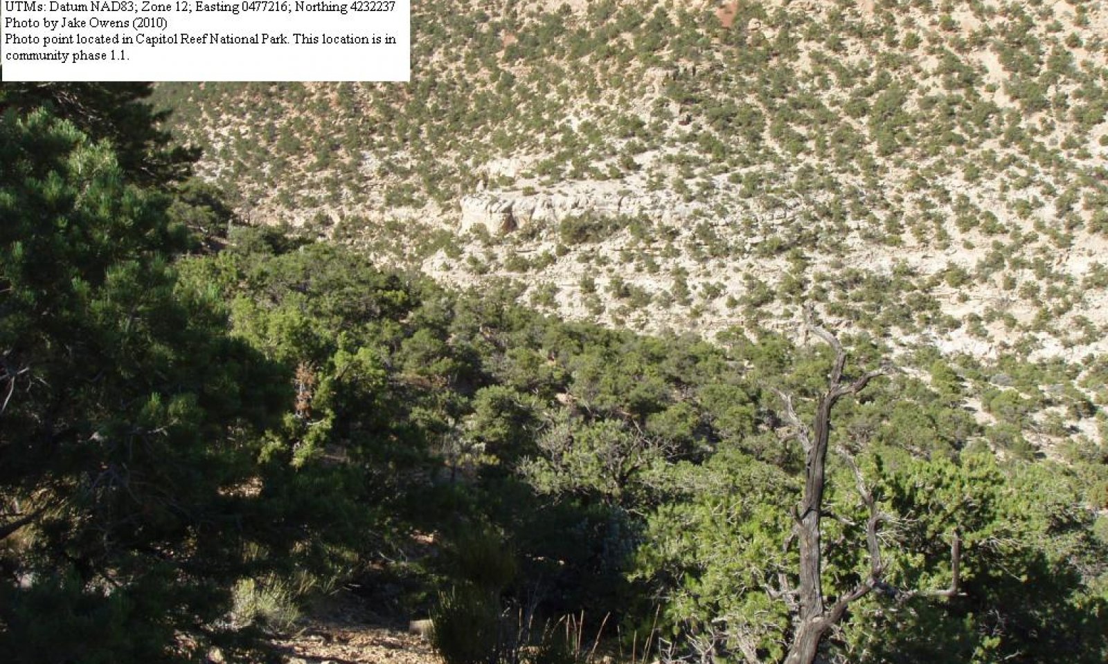
Community 1.1
Pinyon-Utah Juniper Woodland
Figure 3. Pinyon-Utah Juniper Woodland
This plant community phase is characterized by an overstory canopy of two-needle pinyon and Utah juniper, with a shrub and perennial grass understory. Shrubs commonly seen include littleleaf mountainmahogany, buffaloberry and Mormon tea. Grasses that typically inhabit this site include Indian ricegrass and Salina wildrye. Forb composition is variable. Other grasses and shrubs are present; however, species composition varies from one site to the next.
Figure 4. Annual production by plant type (representative values) or group (midpoint values)
Table 5. Annual production by plant type
Plant type Low
(lb/acre)Representative value
(lb/acre)High
(lb/acre)Tree 250 325 425 Shrub/Vine 25 75 150 Grass/Grasslike 30 45 60 Forb 0 15 30 Total 305 460 665 Table 6. Ground cover
Tree foliar cover 10-20% Shrub/vine/liana foliar cover 0-10% Grass/grasslike foliar cover 0-10% Forb foliar cover 0-0% Non-vascular plants 0% Biological crusts 0-10% Litter 10-10% Surface fragments >0.25" and <=3" 0-20% Surface fragments >3" 0-60% Bedrock 0-20% Water 0% Bare ground 10-30% Table 7. Canopy structure (% cover)
Height Above Ground (ft) Tree Shrub/Vine Grass/
GrasslikeForb <0.5 – 0-5% 2-8% 0-1% >0.5 <= 1 – 0-5% 0-8% 0-1% >1 <= 2 – 3-10% 0-8% 0-1% >2 <= 4.5 – 0-5% – – >4.5 <= 13 2-10% – – – >13 <= 40 8-18% – – – >40 <= 80 – – – – >80 <= 120 – – – – >120 – – – – Additional community tables
Table 8. Community 1.1 plant community composition
Group Common name Symbol Scientific name Annual production () Foliar cover (%) Tree0 Trees 250–425 Grass/Grasslike0 Grasses 30–60 crispleaf buckwheat ERCO14 Eriogonum corymbosum 0–20 0–2 mat rockspirea PECAE Petrophytum caespitosum var. elatius 0–10 0–1 stemless four-nerve daisy TEACA2 Tetraneuris acaulis var. acaulis 0–5 0–1 low greenthread THCA11 Thelesperma caespitosum 0–5 0–1 sulphur-flower buckwheat ERUM Eriogonum umbellatum 0–5 0–1 rayless tansyaster MAGR2 Machaeranthera grindelioides 0–5 0–1 cryptantha CRYPT Cryptantha 0–5 0–1 Forb2 Forbs 0–30 littleleaf mountain mahogany CEIN7 Cercocarpus intricatus 0–90 0–6 mormon tea EPVI Ephedra viridis 5–25 1–2 rubber rabbitbrush ERNA10 Ericameria nauseosa 0–20 0–2 Utah serviceberry AMUT Amelanchier utahensis 0–20 0–1 Bigelow sage ARBI3 Artemisia bigelovii 0–15 0–1 Fremont's mahonia MAFR3 Mahonia fremontii 0–15 0–1 currant RIBES Ribes 0–15 0–1 roundleaf buffaloberry SHRO Shepherdia rotundifolia 5–15 0–1 broom snakeweed GUSA2 Gutierrezia sarothrae 0–5 0–1 Shrub/Vine3 Shrubs 25–150 Interpretations
Animal community
--Livestock and Wildlife Grazing--
The scarcity of water on this site limits the species richness and the abundance of large mammals. This site provides thermal cover and limited forage opportunities for mule deer. Birds, Bats, lizards, snakes and rodents are more common. Birds from several families from hawks to sparrows are typical. Golden eagles are red-tailed hawks are common as well as the great horned-owl. Species typical of pinyon juniper areas including black-chinned and rufous hummingbirds, and several fly catchers, wood peckers, and corvids will use this site for nesting and foraging. Several species of rodents forage and occupy this site including desert cottontail, black tailed jack rabbit, Colorado chipmunk, white–tailed Antelope squirrel, Apache pocket mouse, several species of Peromyscus. Coyotes and kit foxes will also forage in the area. Dens are probably located in other ecological sites due to the shallow soils and/or the presence rocks or rock out crops. Bats (Myotis, Pipisturellus, and others) can be observed in this ecological site, but are likely limited to areas near water or canyons.
--Threatened and Endangered Wildlife – This site provides foraging and roosting opportunities for Bald Eagles. Peregrine Falcons will usually nest more to the edge of the cliffs, but due to the typically location of this site near cliffs, the area will provide foraging and resting opportunities. Ferruginous hawks, and Northern Goshawks are also spotted foraging and roosting in this site. When the area is open, suitable nesting habitat for ferruginous hawks exists
--Grazing Interpretations—
Due to the steep slopes associated with this site, livestock grazing is not typically a factor. This site provides fair grazing conditions for wildlife. However, this site often lacks natural perennial water sources, which can influence the suitability for wildlife grazing. Mule deer, desert bighorn sheep, pronghorn antelope, and elk may utilize this site, though in many places the populations will be small and have little grazing impact.
The plant community is primarily Utah Juniper and pinyon; and sub dominant shrubs. Such shrubs provide good winter browse for cattle, sheep, goats, pronghorn antelope, elk, mule deer, and bighorn sheep. Grasses include Indian ricegrass and salina wildrye, and when present these grasses provide good foraging conditions for many classes of livestock and wildlife. Utah juniper and pinyon pine provide good cover for livestock and wildlife; mule deer, pronghorn antelope, and goats may also graze these trees. Forb composition and annual production depends primarily on precipitation amounts and thus is challenging to use in livestock grazing management decisions. However, forb composition should be monitored for species diversity, as well as poisonous or injurious plant communities which may be detrimental to livestock if grazed. Before making specific grazing management recommendations, an onsite evaluation must be made.
--References--
Relative Forage Preference of Plants for Grazing Use by Season: Plants commonly found in Major Land Resource Area D35 --The Colorado Plateau. 2007
Stubbendieck, J., S. L. Hatch, and C. H. Butterfield. 1997. North American range plants. Lincoln, NE: University of Nebraska Press. 501p.
USDA, Forest Service. 2007. Fire effects information: plant species life form. Available at http://www.fs.fed.us/database/feis/plants/index.html. Accessed 7 August 2007.
Hydrological functions
Runoff and Soil Loss
The following runoff and soil loss data was generated using the Rangeland Hydrology and Erosion Model Web Tool (See citation below).
Soil textures range from loam to sandy loam and slope ranges from 40-80 percent on this site. There is no difference in runoff due to soil texture or slope. However, slope does have an impact on soil loss. Average runoff is typically about 1.3 inches/year, but may be as high as 2.5 inches in a single 100-year storm event. Soil loss ranges from 0.75(about 40% slope) to 1.3 (about 80% slope) tons per acre on an average year, and from 1.8 (about 40% slope) to 2.75 (about 80% slope) tons per acre during a 100-year storm event. Long-term soil loss is not a concern on this site, but rather the rare storm events (i.e. 25, 50 or 100 year storms) result in significant soil loss that are more likely to impact the soil resource. Average rainfall ranges from 13-16 inches per year, but a single 100-year storm event can generate 3.4 inches of precipitation in a 24-hour period.
Individual trees, shrubs, and grass are uniformly distributed, resulting in high tortuosity which slows down overland flow and promotes on-site infiltration. Heavy grazing does not significantly alter the hydrology since this site is not typically affected by livestock.
Soil Group Curve Number
The soil is in hydrologic group D. Hydrological groups are used in equations that estimate runoff from rainfall. These estimates are needed for solving hydrologic problems that arise in planning watershed-protection and flood-prevention projects and for designing structures for the use, control and disposal of water. (NRCS National Engineering Handbook). In areas similar to the reference state where ground cover is adequate, infiltration is increased and runoff potential is decreased. In areas where ground cover is less, infiltration is reduced and runoff potential is increased. Surface disturbance including ATV and off-road vehicles tracks, dirt roads, and heavy use by domestic livestock, can affect the hydrology. The trampling/compaction increases bulk density and breaks down soil aggregates. This results in decreased infiltration rates and increased runoff. The actual removal of the plants due to the tire tracks, or grazing can alter the hydrology by decreasing plant cover and increasing bare ground. Fire can also affect hydrology, but it is variable. Fire intensity, fuel type, soil, climate, and topography can each have different influences. Fires can increase areas of bare ground and hydrophobic layers that reduce infiltration and increase runoff. (National Range and Pasture Handbook, 2003)
--References--
National Engineering Handbook. US Department of Agriculture, Natural Resources Conservation Service. Available: http://www.info.usda.gov/CED/Default.cfm#National%20Engineering%20Handbook. Accessed February 25, 2008.
NRCS Grazing Lands Technology Institute. 2003. National Range and Pasture Handbook. Fort Worth, TX, USA: US Department of Agriculture, Natural Resources Conservation Service, 190-VI-NRPH.
Southwest Watershed Research Center. 2008. Rangeland Hydrology and Erosion Model Web Tool. Tuscon, Arizona, USA: US Department of Agriculture, Agricultural Research Service. Available at http://apps.tucson.ars.ag.gov/rhem/. Accessed on Dec, 2010.Recreational uses
Recreation activities include aesthetic value; and fair opportunities for hiking and hunting.
Wood products
Wood products are firewood and fenceposts.
Other information
--Poisonous and Toxic Plant Communities--
Toxic plants associated with this site include woolly locoweed, broom snakeweed, and wavy leaf (Havard) oak. Woolly locoweed is toxic to all classes of livestock and wildlife. Locoweed is palatable and has similar nutrient value to alfalfa, which may cause animals to consume it even when other forage is available. Locoweed contains swainsonine (indolizdine alkaloid) and is poisonous at all stages of growth. Poisoning will become evident after 2-3 weeks of continuous grazing and is associated with 4 major symptoms: 1) neurological damage, 2) emaciation, 3) reproductive failure and abortion, and 4) congestive heart failure linked with “high mountain disease”. Broom snakeweed contains steroids, terpenoids, saponins, and flavones that can cause abortions or reproductive failure in sheep and cattle, however cattle are most susceptible. These toxins are most abundant during active growth and leafing stage. Cattle and sheep generally will only graze broom snakeweed when other forage is unavailable, typically in winter when toxicity levels are at their lowest (Knight and Walter, 2001). Havard oak is thought to contain tannins that can be detrimental to cattle, sheep, and occasionally horses if grazed as more than 50% of the diet. Oak is highly toxic during the budding stage, leafing stage, and when acorns are available. Symptoms include lack of appetite, weakness, excessive thirst, edema, reluctance to follow the herd, and emaciation
--Invasive Plant Communities--
Generally as ecological conditions deteriorate and perennial vegetation decreases due to disturbance (fire, over grazing, drought, off road vehicle overuse, erosion, etc.) annual forbs and grasses will invade the site. Of particular concern in semi-arid environments are the annual invaders including cheatgrass, Russian thistle, kochia, halogeton, and annual mustards. The presence of these species will depend on soil properties and moisture availability; however, these invaders are highly adaptive and can flourish in many locations. Once established, complete removal is difficult but suppression may be possible. On well developed Utah juniper and pinyon pine communities soils are completly occupied by lateral roots, which inhibit an herbaceous understory as well as annual invasions. However once these sites are disturbed and pinyon-juniper communities begin to decline invasion is possible.
--Fire Ecology--
The ability for an ecological site to carry fire depends primarily on the present fuel load and plant moisture content—sites with small fuel loads will burn more slowly and less intensely than sites with large fuel loads. Many semi-desert communities in the Colorado Plateau may have evolved without the influence of fire. However a year of exceptionally heavy winter rains can generate fuels by producing heavy stands of annual forbs and grasses. When fires do occur, the effect on the plant community may be extreme due to the harsh environment and slow rate of recovery.
There is no evidence that this site historically maintained a short burn frequency. Only a few species in the association show fire scars and can be aged. This ecological site is comprised of scattered junipers and pinyons with bare interspaces to patchy occurrence of grasses, which is unlikely to carry a fire unless under high winds, high temperature, and low humidity. Currently, burning is not a recommended brush management tool. If annual grasses or forbs dominate the area after disturbance, re-vegetating efforts could be hampered due to several factors including an increase in fire frequency.
--References--
Knight, A. P. and R. G. Walter. 2001. A guide to plant poisoning of animals in North America. Jackson, WY: Teton NewMedia. 367p.
USDA, Forest Service. 2007. Fire effects information: plant species life form. Available at http://www.fs.fed.us/database/feis/plants/index.html. Accessed 7 August 2007.
Supporting information
Type locality
Location 1: Wayne County, UT UTM zone N UTM northing 4232237 UTM easting 0477216 General legal description Miners Mountain Other references
Betancourt, J. L., E. A. Pierson, K. A. Rylander, J. A. Fairchild-Parks, and J. S. Dean. 1993. Influence of history and climate on New Mexico pin˜on-juniper woodlands. Pages 42–62 in E. F. Aldon, and D. W. Shaw, editors. Managing pinon-juniper ecosystems for sustainability and social needs. USDA Forest Service Technical Report RM-236.
Knight, A.P. and R.G. Walter. 2001. A guide to plant poisoning of animals in North America. Teton NewMedia. Jackson, WY.
National Engineering Handbook. US Department of Agriculture, Natural Resources Conservation Service. Available: http://www.info.usda.gov/CED/Default.cfm#National%20Engineering%20Handbook. Accessed February 25, 2008.
NPS.gov. 2008. Canyonlands National Park. Nature and Science. Available: http://www.nps.gov/cany/naturescience/. Accessed on January 4, 2008.
NRCS Grazing Lands Technology Institute. 2003. National Range and Pasture Handbook. Fort Worth, TX, USA: US Department of Agriculture, Natural Resources Conservation Service, 190-VI-NRPH.
Utah Climate Summaries. 2009. Available: http://www.wrcc.dri.edu/summary/climsmut.html. Accessed on February 25, 2008.
**Utah Division of Wildlife Resources. 2007. Utah’s federally (US F&WS) listed threatened, endangered, and candidate species. Available: http://dwrcdc.nr.utah.gov/ucdc/ViewReports/te_list.pdf. Accessed on February 25, 2008.
Contributors
Jake Owens And Jamin Johanson
Rangeland health reference sheet
Interpreting Indicators of Rangeland Health is a qualitative assessment protocol used to determine ecosystem condition based on benchmark characteristics described in the Reference Sheet. A suite of 17 (or more) indicators are typically considered in an assessment. The ecological site(s) representative of an assessment location must be known prior to applying the protocol and must be verified based on soils and climate. Current plant community cannot be used to identify the ecological site.
Author(s)/participant(s) Contact for lead author Date 01/06/2011 Approved by Approval date Composition (Indicators 10 and 12) based on Annual Production Indicators
-
Number and extent of rills:
Frequent. Occur throughout the site. Rills may extend down entire slope. -
Presence of water flow patterns:
Frequent and occur throughout area. Flow patterns wind between the surface rocks. -
Number and height of erosional pedestals or terracettes:
Pedestals form at the base of plants that occur on the edge of rills and gullies. Gullies may remove soil from the base of trees exposing roots that resemble pedestals. Interspaces between well developed biological soil crusts resemble pedestals and may be up to 2 inches high. Terracettes are present. Debris dams of small to medium sized litter (up to 2 inches in diameter) may form in water flow patterns, rills, and gullies. These debris dams may accumulate smaller litter (leaves, grass and forb stems). -
Bare ground from Ecological Site Description or other studies (rock, litter, lichen, moss, plant canopy are not bare ground):
10 – 30 %. Most bare ground is associated with water flow patterns, rills, and gullies. Areas with well developed biological soil crusts should not be counted as bare ground. Poorly developed biological soil crusts that are interpreted as functioning as bare ground (therefore they would be susceptible to raindrop splash erosion) should be recorded as bare ground. Ground cover is based on first raindrop impact, and bare ground is the opposite of ground cover. -
Number of gullies and erosion associated with gullies:
Gullies may be present. Length often extends from exposed bedrock until gully reaches a stream or an area where water and sediment accumulate, but they may be wide and shallow and armored with very large rocks. Gullies may remove soil from base of trees exposing roots. -
Extent of wind scoured, blowouts and/or depositional areas:
None to very few. Trees reduce the potential for wind erosion. -
Amount of litter movement (describe size and distance expected to travel):
Fine litter is moved with even moderate precipitation events and spring runoff, accumulating down slope behind plants and rock features in the site. Woody stems may be washed from site. Gullies may remove accumulated litter from under trees. -
Soil surface (top few mm) resistance to erosion (stability values are averages - most sites will show a range of values):
This site should have a soil stability rating of 4 or 5 under the plant canopies using the soil stability kit test, and a rating of 3 to 4 in the interspaces. The average should be a 4. Vegetation cover, litter, biological soil crusts and surface rock reduce erosion. -
Soil surface structure and SOM content (include type of structure and A-horizon color and thickness):
Soil surface is 1 inch deep. There is little if any difference under canopy or in interspaces and a recognizable A horizon is expected to be present throughout. Use the specific information for the soil you are assessing found in the published soil survey to supplement this description. -
Effect of community phase composition (relative proportion of different functional groups) and spatial distribution on infiltration and runoff:
Spatial distribution of plants and/or well developed biological soil crusts (where present) intercept raindrops reducing splash erosion and provide areas of surface detention to store water allowing additional time for infiltration. Crowns of trees and accumulating litter at base of trees appear to create a micro-topography that may enhance development of water flow patterns below the drip line of the canopy. Significant increases in Pinyon-juniper canopy (beyond the reference state) reduces understory vegetation causing an associated increase in runoff. -
Presence and thickness of compaction layer (usually none; describe soil profile features which may be mistaken for compaction on this site):
None. There may be layers of calcium carbonate or other naturally occurring hard layers found in the soil subsurface. These should not be considered to be compaction layers. -
Functional/Structural Groups (list in order of descending dominance by above-ground annual-production or live foliar cover using symbols: >>, >, = to indicate much greater than, greater than, and equal to):
Dominant:
Dominance by average annual production: Perennial bunchgrasses > Shrubs > Trees (Pinion > Juniper) > forbs. Functional/structural groups may appropriately contain non-native species if their ecological function is the same as the native species in the reference state (e.g. Crested wheatgrass, Intermediate wheatgrass, etc.) Dominants— Salina Wildrye, Utah Juniper, Pinyon Pine Indian ricegrass and forbs. Perennial and annual forbs can be expected to vary widely in their expression in the plant community based upon departures from average growing conditions.Sub-dominant:
Other:
Additional:
Biological soil crust is variable in it’s expression where present on this site and is measured as a component of ground cover. Following a recent disturbance such as fire, drought, or insects that removes the woody vegetation, forbs and perennial grasses (herbaceous species) may dominate the community. If a disturbance has not occurred for an extended period of time, woody species may continue to increase crowding out the perennial herbaceous understory species. In either case, these conditions would reflect a functional community phase within the reference state. -
Amount of plant mortality and decadence (include which functional groups are expected to show mortality or decadence):
Community is made up of young, mid, and old aged juniper and pinyon trees. Several standing dead trees may be present on the site and approximately 20 % of the trees can show evidence of decadence. All age classes of perennial grasses should be present under average growing condition with a decrease in age class expression under below average conditions, or on sites with high (usually greater than 65%) similarity index (late seral to historic climax). In drought tree mortality may increase with the first sign being a yellowish to reddish leaf color. -
Average percent litter cover (%) and depth ( in):
Litter cover 5-10%. Variability may occur due to weather. -
Expected annual annual-production (this is TOTAL above-ground annual-production, not just forage annual-production):
250-410 #/acre on an average year. -
Potential invasive (including noxious) species (native and non-native). List species which BOTH characterize degraded states and have the potential to become a dominant or co-dominant species on the ecological site if their future establishment and growth is not actively controlled by management interventions. Species that become dominant for only one to several years (e.g., short-term response to drought or wildfire) are not invasive plants. Note that unlike other indicators, we are describing what is NOT expected in the reference state for the ecological site:
Cheatgrass is most likely to invade this site. -
Perennial plant reproductive capability:
All perennial plants should have the ability to reproduce sexually or asexually in most years, except in drought years.
Print Options
Sections
Font
AAAAOther
PrintThe Ecosystem Dynamics Interpretive Tool is an information system framework developed by the USDA-ARS Jornada Experimental Range, USDA Natural Resources Conservation Service, and New Mexico State University.
Accessibility statement